
Grant County International Airport is a public use airport in the northwest United States, located six miles (10 km) northwest of the central business district of Moses Lake in Grant County, Washington. Formerly a military facility, the airport is owned by the Port of Moses Lake, and its 13,500-foot (4,110 m) runway is the 17th longest in the U.S.
Taunton Municipal Airport, also known as King Field, is a public use airport located three nautical miles (6 km) east of the central business district of Taunton, a city in Bristol County, Massachusetts. It is located in the East Taunton neighborhood of the city. The city-owned airport is maintained and operated by the Taunton Airport Commission. According to the FAA's National Plan of Integrated Airport Systems for 2009–2013, it is categorized as a general aviation airport.
Shell Lake Municipal Airport is a city owned public use airport located one nautical mile (2 km) southeast of the central business district of Shell Lake, a city in Washburn County, Wisconsin, United States. It is included in the Federal Aviation Administration (FAA) National Plan of Integrated Airport Systems for 2021–2025, in which it is categorized as a basic general aviation facility.
Airlake Airport is a public use airport in Dakota County, Minnesota, United States. Owned by the Metropolitan Airports Commission, It is approximately 20 miles (32 km) south of both downtown Minneapolis and downtown St. Paul The airport is located near the Twin Cities suburbs of Lakeville and Farmington.
Fitch H. Beach Airport is a city-owned, public-use airport located two nautical miles (3.7 km) northeast of the central business district of Charlotte, a city in Eaton County, Michigan, United States. It is included in the Federal Aviation Administration (FAA) National Plan of Integrated Airport Systems for 2017–2021, in which it is categorized as a local general aviation facility.
Rice Lake Regional Airport is a city owned public use airport located five nautical miles (9 km) southwest of the central business district of Rice Lake, a city in Barron County, Wisconsin, United States. The airport is situated in the village of Cameron. It is included in the Federal Aviation Administration (FAA) National Plan of Integrated Airport Systems for 2021–2025, in which it is categorized as a local general aviation facility.
South Wood County Airport, also known as Alexander Field, is a public use airport located one nautical mile (1.85 km) south of the central business district of Wisconsin Rapids, a city in Wood County, Wisconsin, United States.
Burnett County Airport is a county-owned public use airport located three nautical miles (6 km) north of the central business district of Siren, in Burnett County, Wisconsin, United States. It is included in the Federal Aviation Administration (FAA) National Plan of Integrated Airport Systems for 2021–2025, in which it is categorized as a local general aviation facility.
Red Wing Regional Airport is a city-owned public-use airport located in Pierce County, Wisconsin, three nautical miles (6 km) northeast of the central business district of Red Wing, a city in Goodhue County, Minnesota, United States.
Delta Junction Airport is a public use airport located in and owned by Delta Junction, a city in the Southeast Fairbanks Census Area of the U.S. state of Alaska.
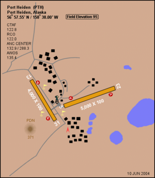
Port Heiden Airport is a state-owned public-use airport located six nautical miles northeast of the central business district of Port Heiden, in the Lake and Peninsula Borough of the U.S. state of Alaska. Scheduled airline service to King Salmon Airport is provided by Peninsula Airways (PenAir).
Port Moller Airport is a publicly owned, private-use airport located 87 nautical miles northeast of the central business district of Cold Bay, in the Aleutians East Borough of the U.S. state of Alaska. It is owned by the U.S. Department of the Interior, Bureau of Land Management. It was previously known as Port Moller Air Force Station.

Clarence E. Page Municipal Airport is a public-use airport owned by the city of Oklahoma City and located in Canadian County, Oklahoma, United States. It is 15 nautical miles (28 km) west of the central business district of Oklahoma City, but still within its city limits. This airport is included in the FAA's National Plan of Integrated Airport Systems (2009–2013), which categorizes it as a general aviation airport.
Kings Land o' Lakes Airport is a public use airport located one nautical mile (1.85 km) southeast of the central business district of the unincorporated community of Land o' Lakes in the town of Land o' Lakes, Vilas County, Wisconsin, United States. It is owned by the town of Land o' Lakes. It is included in the Federal Aviation Administration (FAA) National Plan of Integrated Airport Systems for 2021–2025, in which it is categorized as a local general aviation facility.
Marion County Airport, also known as Brown Field, is a county-owned, public-use airport located four nautical miles southeast of the central business district of Jasper, a town in Marion County, Tennessee, United States.
The Greene County Airport is a county-owned, public-use airport in Franklin Township, Greene County, Pennsylvania, United States. It is located two nautical miles (4 km) east of the central business district of Waynesburg, Pennsylvania. This airport was included in the National Plan of Integrated Airport Systems for 2009–2013, which categorized it as a general aviation facility.
Mooreland Municipal Airport is a city-owned, public-use airport located three nautical miles (6 km) north of the central business district of Mooreland, a city in Woodward County, Oklahoma, United States. It is included in the National Plan of Integrated Airport Systems for 2011–2015, which categorized it as a general aviation facility.
Sequim Valley Airport is a privately owned, public use airport located four nautical miles northwest of the central business district of Sequim, a city in Clallam County, Washington, United States.
Ferndale Airfield is a public use airport in Flathead County, Montana, United States. It is owned by the Flathead Municipal Airport Authority and located three nautical miles (6 km) northeast of the central business district of Bigfork, Montana.
Appleton Municipal Airport, is a public use airport located 2 miles (3 km) northeast of the central business district of Appleton, a city in Swift County, Minnesota, United States. The closest airport with commercial airline service is Watertown Regional Airport about 60 miles (97 km) to the southwest.


