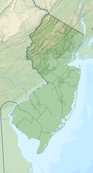
Sussex County is the northernmost county in the State of New Jersey. Its county seat is Newton. It is part of the New York metropolitan area and is part of New Jersey's Skylands Region. As of the 2020 United States Census, the county's population was enumerated at 144,221, making it the 17th-most populous of the state's 21 counties, and representing a decrease of 5,044 (3.4%) from the 149,265 counted at the 2010 U.S. Census, in turn an increase of 5,099 (3.5%) over the 144,166 persons at the 2000 Census. Based on 2010 Census data, Vernon Township was the county's largest in both population and area, with a population of 23,943 and covering an area of 70.59 square miles (182.8 km2).

Frankford Township is a township in Sussex County, New Jersey, United States. As of the 2010 United States Census, the township's population was 5,565, reflecting an increase of 145 (+2.7%) from the 5,420 counted in the 2000 Census, which had in turn increased by 306 (+6.0%) from the 5,114 counted in the 1990 Census.

Hardyston Township is a township in Sussex County, New Jersey, United States. As of the 2010 United States Census, the township's population was 8,213, reflecting an increase of 2,042 (+33.1%) from the 6,171 counted in the 2000 Census, which had in turn increased by 896 (+17.0%) from the 5,275 counted in the 1990 Census.

Vernon Township is a township in Sussex County, New Jersey, United States. It is located about one hour's drive from New York City and is part of the New York Metropolitan Area. As of the 2010 United States Census, the township's population was 23,943, reflecting a decline of 743 (-3.0%) from the 24,686 counted in the 2000 Census, which had in turn increased by 3,475 (+16.4%) from the 21,211 counted in the 1990 Census. It is both the most populous municipality and the largest in area in the county.
Wantage Township is a township in Sussex County, New Jersey, United States. As of the 2010 United States Census, the township's population was 11,358, reflecting an increase of 971 (+9.3%) from the 10,387 counted in the 2000 Census, which had in turn increased by 900 (+9.5%) from the 9,487 counted in the 1990 Census.

The Wallkill River, a tributary of the Hudson, drains Lake Mohawk in Sparta, New Jersey, flowing from there generally northeasterly 88.3 miles (142.1 km) to Rondout Creek in New York, just downstream of Sturgeon Pool, near Rosendale, with the combined flows reaching the Hudson at Kingston.

The Paulins Kill is a 41.6-mile (66.9 km) tributary of the Delaware River in northwestern New Jersey in the United States. With a long-term median flow rate of 76 cubic feet of water per second (2.15 m³/s), it is New Jersey's third-largest contributor to the Delaware River, behind the Musconetcong River and Maurice River. The river drains an area of 176.85 square miles (458.0 km2) across portions of Sussex and Warren counties and 11 municipalities. It flows north from its source near Newton, and then turns southwest. The river sits in the Ridge and Valley geophysical province.

Papakating Creek is a 20.1-mile-long (32.3 km) tributary of the Wallkill River located in Frankford and Wantage townships in Sussex County, New Jersey in the United States. The creek rises in a small swamp located beneath the eastern face of Kittatinny Mountain in Frankford and its waters join the Wallkill to the east of Sussex borough.
Clove Brook is a 12.0-mile-long (19.3 km) tributary of Papakating Creek in Sussex County, New Jersey in the United States.

Lake Swannanoa is a residential lake community located within Jefferson Township, in Morris County, New Jersey, United States. It is within the scenic Skylands Region and approximately 38 miles (61 km) by road from New York City.
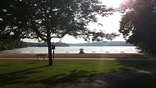
Swartswood State Park is a 3,460-acre (14.0 km2) protected area located in the Swartswood section of Stillwater and Hampton townships in Sussex County, New Jersey, in the United States. Established in 1915 by the state's Forest Park Reservation Commission, it was the first state park established by the state of New Jersey for the purposes of recreation at the state's third-largest freshwater lake. Today, Swartswood State Park is operated and maintained by the New Jersey Division of Parks and Forestry.

Fishkill Creek is a tributary of the Hudson River in Dutchess County, New York, United States. At 33.5 miles (53.9 km) it is the second longest stream in the county, after Wappinger Creek. It rises in the town of Union Vale and flows generally southwest to a small estuary on the Hudson just south of Beacon. Part of its 193-square-mile (500 km2) watershed is in Putnam County to the south. Sprout Creek, the county's third-longest creek, is its most significant tributary. Whaley and Sylvan lakes and Beacon Reservoir, its largest, deepest and highest lakes, are among the bodies of water within the watershed.

Pochuck Mountain is a ridge in the New York-New Jersey Highlands region of the Appalachian Mountains. Pochuck Mountain's summit and most of its peaks lie within Vernon Township, Sussex County, New Jersey, although the south-western portion of the ridge lies within Hardyston Township, and the north-eastern tip of the ridge extends over the New York state line into Orange County. The ridge marks the eastern edge of the Great Appalachian Valley, and it divides the watersheds of the Wallkill River and its tributary Pochuck Creek. The two rivers meet at Pochuck Neck, marking the terminus of the ridge.

The Kittatinny Valley is a section of the Great Appalachian Valley in Sussex and Warren counties in northwestern New Jersey that is bounded on the west by Kittatinny Mountain, and in the east by the Highlands region. The valley is roughly 39 miles (63 km) long, with an average breadth of 10 miles (16 km) through the center of Sussex and Warren Counties.
The Whippany River Watershed Action Committee (WRWAC) is a member-based, nonprofit 501(c)(3) organization, which identifies and implements projects to preserve and protect water and the surrounding natural areas. The Whippany River Watershed is an area of 69.3 square miles within Morris County in north central New Jersey. The 16-mile long Whippany River serves the only significant unconsolidated aquifer in northern New Jersey and is a source of drinking water for more than 1 million people.
Oley Creek is a tributary of Nescopeck Creek in Luzerne County, Pennsylvania, in the United States. It is approximately 5.2 miles (8.4 km) long. It flows through Foster Township, Dennison Township, and Butler Township. Long Hollow is a tributary of the creek. The creek's watershed has an area of 7.2 square miles (19 km2). It is a high-quality coldwater fishery in its upper reaches and a Class A Wild Trout Fishery for part of its distance. The creek is in the upper reaches of the Nescopeck Creek watershed. It is named after a community in Berks County, Pennsylvania known as Oley.

Mud Creek is a tributary of Chillisquaque Creek in Columbia County and Montour County in Pennsylvania, in the United States. It is approximately 8.3 miles (13.4 km) long and flows through Madison Township, Columbia County and Derry Township, Montour County. The main tributaries of the creek are unnamed tributaries. The creek's watershed has an area of 17.70 square miles and is in West Hemlock Township, Montour County as well as the two townships it flows through. The watershed is mostly agricultural and forested and the main developed areas are Washingtonville and Jerseytown.

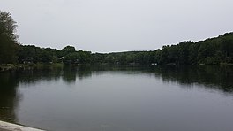
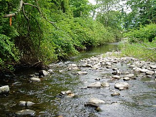
Neepaulakating Creek is a 2.4-mile long (3.8 km) tributary of Papakating Creek in Wantage Township in Sussex County, New Jersey in the United States. It is one of three streams feeding the Papakating Creek, a major contributor to the Wallkill River. Although the stream was dammed in the 1950s to create Lake Neepaulin as the focal point of a private residential development, the stream did not receive a name until 2002. Residents chose a name that combined elements of the names "Neepaulin" and "Papakating", and submitted a proposal to the United States Board of Geographic Names. The name was approved in 2004.
West Branch Papakating Creek is a tributary of Papakating Creek located in Frankford and Wantage townships in Sussex County, New Jersey, in the United States.