
Nobles County is a county in the U.S. state of Minnesota. As of the 2020 United States Census, the population was 22,290. Its county seat is Worthington.
Jackson County is a county in the U.S. state of Minnesota. As of the 2020 United States Census, the population was 9,989. Its county seat is Jackson.

Okabena is a town in Jackson County, Minnesota, United States. The population was 188 at the 2010 census. The community's name is a Dakota term meaning "the nesting place of herons."

Graham Lakes Township is a township in Nobles County, Minnesota, United States. The population was 251 at the 2000 census.
Worthington Township is a township in Nobles County, Minnesota, United States. The population was 316 at the 2000 census.

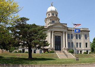
Worthington is a city in and the county seat of Nobles County, Minnesota, United States. The population was 13,947 at the 2020 census.

The Red River is a river in the north-central United States and central Canada. Originating at the confluence of the Bois de Sioux and Otter Tail rivers between the U.S. states of Minnesota and North Dakota, it flows northward through the Red River Valley, forming most of the border of Minnesota and North Dakota and continuing into Manitoba. It empties into Lake Winnipeg, whose waters join the Nelson River and ultimately flow into Hudson Bay.

The Des Moines River is a tributary of the Mississippi River in the upper Midwestern United States that is approximately 525 miles (845 km) long from its farther headwaters. The largest river flowing across the state of Iowa, it rises in southern Minnesota and flows across Iowa from northwest to southeast, passing from the glaciated plains into the unglaciated hills near the capital city of Des Moines, named after the river, in the center of the state. The river continues to flow at a southeastern direction away from Des Moines, later flowing directly into the Mississippi River.
Watershed districts are special government entities in the U.S. state of Minnesota that monitor and regulate the use of water in watersheds surrounding various lakes and rivers in the state. The districts cover the natural regions of the watersheds, rather than politically defined regions and thus may have boundaries that cross jurisdictions. They are run by a board of managers, who are appointed by commissions in the counties within the districts.

Lake Pepin is a naturally occurring lake on the Mississippi River on the border between the U.S. states of Minnesota and Wisconsin. It is located in a valley carved by the outflow of an enormous glacial lake at the end of the last Ice Age. The lake formed when the Mississippi, a successor to the glacial river, was partially dammed by a delta from a tributary stream and spread out across the ancient valley.
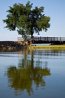
Lake Shetek is the largest lake in southwestern Minnesota, United States, and the headwaters of the Des Moines River. It is located in The Lakes, an unincorporated community in Murray County a few miles north-northwest of Currie. The name Shetek is derived from "pelican" in the Ojibwe language.
Nicollet Island/East Bank is a neighborhood in Minneapolis, Minnesota, situated just across the Mississippi River from Downtown, one of six in the University community. It comprises Nicollet Island and the portion of the eastern riverbank located between Central Avenue and the Burlington Northern-Santa Fe Railroad line. The "East Bank" portion of the neighborhood is commonly referred to as a part of Northeast or Old St. Anthony, as this area was the location of the town of St. Anthony, which was annexed by Minneapolis in 1872.
Rice Creek is a tributary of the Mississippi River in the northern suburbs of the Minneapolis–St. Paul metropolitan area of Minnesota in the United States. It is approximately 28 miles (45 km) long and drains a watershed of 201 square miles (520 km2).

The Minnesota Southern Railway was a shortline railroad in the states of Minnesota and South Dakota in the United States.
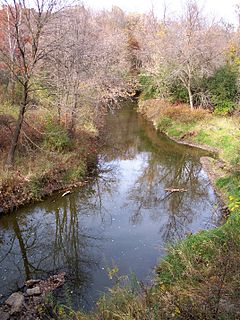
Okabena Creek is a 40-mile-long (64 km) waterway in southern Minnesota. It is a tributary, via the short Diversion Creek, of Heron Lake, the outlet of which flows to the Des Moines River. Okabena Creek begins in Worthington, Minnesota, connecting by a ditch to the outlet of Okabena Lake, then flows northeast past the towns of Brewster and Okabena to the Heron Lake/South Heron Lake system.
Org is an unincorporated community in Nobles County, Minnesota, United States.
Reading is an unincorporated community in Nobles County, Minnesota, United States.

The Burlington, Cedar Rapids and Northern Railway (BCR&N) was a railroad that operated in the United States from 1876 to 1903. It was formed to take over the operations of the bankrupt Burlington, Cedar Rapids and Minnesota Railway, which was, in turn, the result of merging several predecessor lines, the construction of which began in 1869. The corporate headquarters were in Cedar Rapids, Iowa, and it had operations in Iowa and in Minnesota. It was succeeded by the Chicago, Rock Island and Pacific Railway.

The Graham Lakes are a pair of lakes located in the northeastern corner of Nobles County, Minnesota. The lakes are known as West Graham Lake and East Graham Lake. West Graham Lake is an oval shaped body of water that extends east-to-west slightly more than one mile (1.6 km). The north-to-south width of the lake is approximately 3/4 of a mile. The area of West Graham Lake is 519.28 acres (2.1015 km2), the average depth is 5 feet (1.5 m), and the maximum depth is 8 feet (2.4 m). The elevation of West Graham Lake is 1,438.7 feet (438.5 m), or 438.52 meters. East Graham Lake is a longer, narrower lake that extends from northeast-to-southwest for 11⁄2 miles. Its width is less than 1/2 mile. The area of East Graham Lake is 511.32 acres (2.0692 km2), the average depth is 5 feet (1.5 m), and the maximum depth is 8 feet (2.4 m). The elevation of East Graham Lake is 1,435.08 feet (437.41 m), or 437.41 meters. A small creek runs from West Graham Lake and empties into East Graham Lake. Another creek runs from East Graham Lake, and eventually flows into the Des Moines River.

Hartsdale was a town in St. John Township, Lake County, Indiana, United States. It was part of the Chicago metropolitan area. Hartsdale was annexed by Schererville, Indiana, in 1911.


