Lake Ozark, Missouri

Last updated

Lake Ozark, Missouri
UserKTrimble-AP of Bagnell Dam MO 2011-03-01.jpg
Miller County Missouri Incorporated and Unincorporated areas Lake Ozark Highlighted.svg
Location in Miller County and the state of Missouri
Coordinates: 38°11′21″N92°37′47″W / 38.18917°N 92.62972°W / 38.18917; -92.62972
Country United States
State Missouri
Counties Miller, Camden
Named for Lake of the Ozarks
Government
   Mayor Dennis Newberry [1]
  City AdministratorHarrison Fry [2]
Area
[3]
  Total7.91 sq mi (20.48 km2)
  Land7.19 sq mi (18.62 km2)
  Water0.72 sq mi (1.87 km2)
Elevation
[4]
623 ft (190 m)
Population
 (2020) [5]
  Total2,077
  Density288.95/sq mi (111.57/km2)
Time zone UTC-6 (Central (CST))
  Summer (DST) UTC-5 (CDT)
ZIP code
65049
Area code 573
FIPS code 29-40034 [6]
GNIS feature ID2395596 [4]
Website cityoflakeozark.net

Lake Ozark is a city in Camden and Miller counties in the U.S. state of Missouri, near its namesake, the Lake of the Ozarks. The population was 2,077 at the 2020 census. [5]

Contents

History

A post office called Lake Ozark has been in operation since 1932. [7] The community took its name from the nearby Lake of the Ozarks. [8]

Bagnell Dam was added to the National Register of Historic Places in 2008. [9]

The segment of Bagnell Dam Boulevard from Horse Bend Parkway to the Bagnell Dam is named "Bagnell Dam Strip." There are two muffler mans named Injun Joe and another named Country Bumpkin. The latter was gone from 2013 until 2024. It unfortunately suffered damage on the shoe part from vandalism a few weeks after returning. [10]

Geography

The city is in western Miller County, with a portion crossing into eastern Camden County. The city sits at the northeast (downstream) end of the Lake of the Ozarks, with the lakeshore forming portions of the city's western border. The city is bordered to the northeast by the town of Bagnell and to the south by the city of Osage Beach. Lake Ozark encircles the smaller, inactive city of Lakeside.

U.S. Route 54 passes through the east side of the city, while Route 54 Business passes through the center. US 54 leads north 12 miles (19 km) to Eldon and northeast 41 miles (66 km) to Jefferson City, the state capital, while to the south it passes through Osage Beach and leads 12 miles (19 km) to Camdenton. The Lake of the Ozarks Community Bridge carries Highway MM across the lake from the southwest part of the city; the highway leads west 9 miles (14 km) to Sunrise Beach.

According to the U.S. Census Bureau, the city of Lake Ozark has a total area of 7.91 square miles (20.49 km2), of which 7.19 square miles (18.62 km2) are land and 0.72 square miles (1.86 km2), or 9.10%, are water. [11]

Climate

Lake Ozark has a humid subtropical climate. Summers are hot and humid, with thunderstorms and other severe weather common. Winters are generally cold with mild periods, but the temperature of the lake can alter the climate with heavy fog and milder weather than other municipalities further away from the lake. Winters also consist of occasional snowfall of about 10 inches per year.

Climate data for Lake Ozark, Missouri (1991–2020 normals, extremes 1931–present)
MonthJanFebMarAprMayJunJulAugSepOctNovDecYear
Record high °F (°C)79
(26)
81
(27)
87
(31)
94
(34)
102
(39)
106
(41)
114
(46)
110
(43)
106
(41)
95
(35)
87
(31)
79
(26)
114
(46)
Mean maximum °F (°C)65.8
(18.8)
70.8
(21.6)
78.1
(25.6)
84.4
(29.1)
88.3
(31.3)
92.1
(33.4)
96.9
(36.1)
97.2
(36.2)
91.7
(33.2)
85.9
(29.9)
75.4
(24.1)
67.7
(19.8)
98.6
(37.0)
Mean daily maximum °F (°C)44.0
(6.7)
48.7
(9.3)
59.0
(15.0)
69.1
(20.6)
76.9
(24.9)
85.0
(29.4)
89.4
(31.9)
88.3
(31.3)
81.1
(27.3)
70.5
(21.4)
58.5
(14.7)
47.9
(8.8)
68.2
(20.1)
Daily mean °F (°C)34.6
(1.4)
38.7
(3.7)
48.0
(8.9)
57.9
(14.4)
66.3
(19.1)
75.0
(23.9)
79.5
(26.4)
78.2
(25.7)
70.8
(21.6)
59.9
(15.5)
48.7
(9.3)
38.9
(3.8)
58.0
(14.4)
Mean daily minimum °F (°C)25.3
(−3.7)
28.6
(−1.9)
37.1
(2.8)
46.8
(8.2)
55.7
(13.2)
65.0
(18.3)
69.5
(20.8)
68.2
(20.1)
60.5
(15.8)
49.2
(9.6)
38.9
(3.8)
29.9
(−1.2)
47.9
(8.8)
Mean minimum °F (°C)5.5
(−14.7)
10.2
(−12.1)
18.7
(−7.4)
30.7
(−0.7)
40.5
(4.7)
53.0
(11.7)
59.2
(15.1)
58.2
(14.6)
45.7
(7.6)
33.1
(0.6)
22.3
(−5.4)
11.8
(−11.2)
2.5
(−16.4)
Record low °F (°C)−15
(−26)
−13
(−25)
−10
(−23)
18
(−8)
30
(−1)
41
(5)
45
(7)
43
(6)
33
(1)
19
(−7)
6
(−14)
−15
(−26)
−15
(−26)
Average precipitation inches (mm)2.15
(55)
2.05
(52)
2.99
(76)
4.98
(126)
5.54
(141)
4.16
(106)
3.83
(97)
4.20
(107)
4.16
(106)
3.42
(87)
2.97
(75)
2.12
(54)
42.57
(1,081)
Average snowfall inches (cm)1.7
(4.3)
0.6
(1.5)
0.3
(0.76)
0.0
(0.0)
0.0
(0.0)
0.0
(0.0)
0.0
(0.0)
0.0
(0.0)
0.0
(0.0)
0.0
(0.0)
0.0
(0.0)
1.7
(4.3)
4.3
(11)
Average precipitation days (≥ 0.01 in)6.66.39.610.411.89.47.97.97.67.77.16.598.8
Average snowy days (≥ 0.1 in)1.10.30.10.00.00.00.00.00.00.00.00.41.9
Source: NOAA [12] [13]

Demographics

Historical population
CensusPop.Note
1970 507
1980 5345.3%
1990 68127.5%
2000 1,489118.6%
2010 1,5866.5%
2020 2,07731.0%
U.S. Decennial Census [14]

2020 census

As of the 2020 census, the population was 2,077.

2010 census

As of the census [15] of 2010, there were 1,586 people, 715 households, and 455 families living in the city. The population density was 219.4 inhabitants per square mile (84.7/km2). There were 1,688 housing units at an average density of 233.5 per square mile (90.2/km2). The racial makeup of the city was 96.5% White, 0.2% African American, 0.7% Native American, 0.8% Asian, 0.2% Pacific Islander, 0.3% from other races, and 1.3% from two or more races. Hispanic or Latino of any race were 1.2% of the population.

There were 715 households, of which 25.5% had children under the age of 18 living with them, 52.9% were married couples living together, 7.6% had a female householder with no husband present, 3.2% had a male householder with no wife present, and 36.4% were non-families. 29.8% of all households were made up of individuals, and 9.4% had someone living alone who was 65 years of age or older. The average household size was 2.22 and the average family size was 2.71.

The median age in the city was 48 years. 19.2% of residents were under the age of 18; 6.5% were between the ages of 18 and 24; 19.7% were from 25 to 44; 36.9% were from 45 to 64; and 17.7% were 65 years of age or older. The gender makeup of the city was 51.3% male and 48.7% female.

2000 census

As of the census [6] of 2000, there were 1,489 people, 649 households, and 427 families living in the city. The population density was 211.6 inhabitants per square mile (81.7/km2). There were 1,143 housing units at an average density of 162.4 per square mile (62.7/km2). The racial makeup of the city was 96.24% White, 1.34% Native American, 0.47% Asian, 0.40% African American, 0.47% from other races, and 1.07% from two or more races. Hispanic or Latino of any race were 2.15% of the population.

There were 649 households, out of which 26.5% had children under the age of 18 living with them, 53.5% were married couples living together, 8.8% had a female householder with no husband present, and 34.1% were non-families. 28.4% of all households were made up of individuals, and 6.3% had someone living alone who was 65 years of age or older. The average household size was 2.29 and the average family size was 2.76.

In the city, the population was spread out, with 21.6% under the age of 18, 7.7% from 18 to 24, 26.7% from 25 to 44, 30.5% from 45 to 64, and 13.6% who were 65 years of age or older. The median age was 41 years. For every 100 females there were 103.1 males. For every 100 females age 18 and over, there were 104.4 males.

The median income for a household in the city was $37,386, and the median income for a family was $40,515. Males had a median income of $26,750 versus $21,667 for females. The per capita income for the city was $20,830. About 11.3% of families and 13.1% of the population were below the poverty line, including 19.2% of those under age 18 and 5.8% of those age 65 or over.

Infrastructure

Roads

Route 242 (MO 242), a four-lane highway which connects the Lake of the Ozarks Community Bridge to U.S. Highway 54, opened in December 2011. [16] At the junction of US 54 and Route W in the northern part of Lake Ozark, an interchange was completed in 2021 to replace a spotlight intersection. [17]

Related Research Articles

<span class="mw-page-title-main">Miller County, Missouri</span> County in Missouri, United States

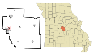
Miller County is a county located in the U.S. state of Missouri. As of the 2020 United States census, the population was 24,722. Its county seat is Tuscumbia. The county was organized February 6, 1837, and named for John Miller, former U.S. Representative and Governor of Missouri.

<span class="mw-page-title-main">Winton, Minnesota</span> City in Minnesota, United States

Winton is a city in Saint Louis County, Minnesota, United States. The population was 172 at the 2010 census. The city is home to a small hydroelectric dam on the edge of Garden Lake, one of 11 stations owned by Minnesota Power.

<span class="mw-page-title-main">Warsaw, Missouri</span> City in Missouri, United States

Warsaw is a city located in Benton County, Missouri, United States. The population was 2,209 at the 2020 census. Warsaw is the county seat of Benton County.

<span class="mw-page-title-main">Camdenton, Missouri</span> City in Missouri, US

Camdenton is a city in and the county seat of Camden County, Missouri, United States. Its population was 3,718 at the 2010 census. The city is enveloped by the Lower Niangua arm of the Lake of the Ozarks, and serves as a popular trade point for visitors to the area.

<span class="mw-page-title-main">Linn Creek, Missouri</span> City in Missouri, United States

Linn Creek is a city in Camden County, Missouri, United States. The population was 216 at the 2020 census.

<span class="mw-page-title-main">Jerico Springs, Missouri</span> Village in Missouri, United States

Jerico Springs is a village in Cedar County, Missouri, United States. The population was 160 at the 2020 census.

<span class="mw-page-title-main">Ozark, Missouri</span> City in Missouri, United States

Ozark is a city in and the county seat of Christian County, Missouri. Its population was 21,284 as of the 2020 census. Ozark is also the third largest city in the Springfield, Missouri Metropolitan Area, and is centered along a business loop of U.S. Route 65, where it intersects with Missouri Route 14.

<span class="mw-page-title-main">Buffalo, Missouri</span> City in Missouri, United States

Buffalo is a city in and the county seat of Dallas County, Missouri, United States. The population was 3,290 at the 2020 census.

<span class="mw-page-title-main">Bagnell, Missouri</span> Town in Missouri, United States

Bagnell is a town in Miller County, Missouri, United States. The population was 43 at the 2020 census, down from 93 in 2010.

<span class="mw-page-title-main">Eldon, Missouri</span> City in the state of Missouri

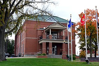
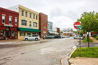
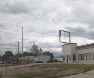
Eldon is a city in Miller County, Missouri, United States, located 30 miles (48 km) southwest of Jefferson City. The population was 4,416 as of the 2020 census.

<span class="mw-page-title-main">Iberia, Missouri</span> City in Missouri, United States

Iberia is a city in southeast Miller County, Missouri, United States. The population was 703 as of the 2020 census.

<span class="mw-page-title-main">Lakeside, Missouri</span> Inactive City in Missouri, United States

Lakeside is an inactive city in Miller County, Missouri, United States, located along the Osage River near the Bagnell Dam. The population was 37 at the 2000 census. However, as of the 2020 census, the city's population was 0, with only one housing unit.

<span class="mw-page-title-main">Laurie, Missouri</span> City in Missouri, US

Laurie is a city in southern Morgan and northern Camden counties, Missouri, United States. The population was 939 at the 2020 census.

<span class="mw-page-title-main">Gainesville, Missouri</span> City in Missouri, United States

Gainesville is a city in Ozark County, Missouri, United States. The population was 745 at the 2020 census. It is the county seat of Ozark County.

<span class="mw-page-title-main">Bowling Green, Missouri</span> City in Missouri, United States

Bowling Green is a city and the county seat of in Pike County, Missouri, United States. The population was 5,334 at the 2010 census.

<span class="mw-page-title-main">Lake Mykee Town, Missouri</span> Village in Missouri, United States

Lake Mykee Town was a village in Callaway County, Missouri, United States whose government was dissolved and land area annexed into Holts Summit, Missouri. Because of this, Lake Mykee no longer exists and the former village is now referred to as Holts Summit. The population was 350 at the 2010 census. It is part of the Jefferson City Metropolitan Statistical Area.

<span class="mw-page-title-main">Indian Point, Missouri</span> Village in Missouri, United States

Indian Point is a village in Stone County, Missouri, United States. The population was 550 at the 2020 census. It is part of the Branson, Missouri Micropolitan Statistical Area.

<span class="mw-page-title-main">Shell Knob, Missouri</span> Census-designated place in Missouri, United States

Shell Knob is a census-designated place (CDP) located within White River Township, Barry County, Missouri. The population was 1,254 at the 2020 census.

<span class="mw-page-title-main">Osage Beach, Missouri</span> City in Missouri, United States

Osage Beach is a city in Camden and Miller counties in the U.S. state of Missouri, near the Lake of the Ozarks. Most of the city is in Camden County, while a small eastern sliver is in Miller County. The population was 4,792 at the 2020 census.

<span class="mw-page-title-main">Sunrise Beach, Missouri</span> Village in Missouri, US

Sunrise Beach is a village in Camden and Morgan counties in the U.S. state of Missouri. The population was 431 at the 2020 census, unchanged from 2010.

References

  1. "Write-In Candidate Dennis Newberry Wins Lake Ozark Mayor Race". LakeExpo. April 6, 2021. Retrieved November 10, 2021.
  2. "Administration". City of Lake Ozark. Retrieved April 16, 2024.
  3. "ArcGIS REST Services Directory". United States Census Bureau. Retrieved August 28, 2022.
  4. 1 2 U.S. Geological Survey Geographic Names Information System: Lake Ozark, Missouri
  5. 1 2 "P1. Race – Lake Ozark city, Missouri: 2020 DEC Redistricting Data (PL 94-171)". U.S. Census Bureau. Retrieved April 16, 2024.
  6. 1 2 "U.S. Census website". United States Census Bureau . Retrieved January 31, 2008.
  7. "Post Offices". Jim Forte Postal History. Retrieved November 6, 2016.
  8. "Miller County Place Names, 1928–1945". The State Historical Society of Missouri. Archived from the original on June 24, 2016. Retrieved November 6, 2016.
  9. "National Register Information System". National Register of Historic Places . National Park Service. March 13, 2009.
  10. "Dimwits Damage Beloved 'Ozark Halfwit' Statue On The Bagnell Dam Strip". LakeExpo.com. May 14, 2024. Retrieved May 16, 2024.
  11. "2023 U.S. Gazetteer Files: Missouri". United States Census Bureau. Retrieved April 16, 2024.
  12. "NOWData – NOAA Online Weather Data". National Oceanic and Atmospheric Administration. Retrieved November 21, 2023.
  13. "Summary of Monthly Normals 1991–2020". National Oceanic and Atmospheric Administration. Retrieved November 21, 2023.
  14. "Census of Population and Housing". Census.gov. Retrieved November 10, 2021.
  15. "U.S. Census website". United States Census Bureau . Retrieved July 8, 2012.
  16. Staff, LakeExpo com. "Highway 242 open to traffic". LakeExpo.com. Retrieved January 12, 2023.
  17. "Route 54 Lake of the Ozarks Interchange (Complete) | Missouri Department of Transportation". www.modot.org. Retrieved January 12, 2023.