
The Purbeck Group is an Upper Jurassic to Lower Cretaceous lithostratigraphic group in south-east England. The name is derived from the district known as the Isle of Purbeck in Dorset where the strata are exposed in the cliffs west of Swanage.

The Dallas–Fort Worth Metroplex sits above Cretaceous-age strata ranging from ≈145-66 Ma. These Cretaceous-aged sediments lie above the eroded Ouachita Mountains and the Fort Worth Basin, which was formed by the Ouachita Orogeny. Going from west to east in the DFW Metroplex and down towards the Gulf of Mexico, the strata get progressively younger. The Cretaceous sediments dip very gently to the east.

The Glen Rose Formation is a shallow marine to shoreline geological formation from the lower Cretaceous period exposed over a large area from South Central to North Central Texas. The formation is most widely known for the dinosaur footprints and trackways found in the Dinosaur Valley State Park near the town of Glen Rose, Texas, southwest of Fort Worth and at other localities in Central Texas.

Terminonaris is a genus of extinct pholidosaurid crocodyliforms that lived during the Late Cretaceous epoch. The name means: “enlarged snout or nose” at the front of the skull. Terminonaris is an early crocodile, within a subgroup called Mesoeucrocodylia. Its remains have only been found in North America and Europe. Originally known under the generic name Teleorhinus, it was once believed to be a teleosaurid. Both prehistoric crocodiles such as Terminonaris, as well as modern crocodiles, belong to the same group called crocodyliformes, although modern crocodiles have specific features that indicate they are distant relatives of this species and members of the subgroup Eusuchia.

The Niobrara Formation, also called the Niobrara Chalk, is a geologic formation in North America that was deposited between 87 and 82 million years ago during the Coniacian, Santonian, and Campanian stages of the Late Cretaceous. It is composed of two structural units, the Smoky Hill Chalk Member overlying the Fort Hays Limestone Member. The chalk formed from the accumulation of coccoliths from microorganisms living in what was once the Western Interior Seaway, an inland sea that divided the continent of North America during much of the Cretaceous. It underlies much of the Great Plains of the US and Canada. Evidence of vertebrate life is common throughout the formation and includes specimens of plesiosaurs, mosasaurs, and pterosaurs as well as several primitive aquatic birds. The type locality for the Niobrara Chalk is the Niobrara River in Knox County in northeastern Nebraska. The formation gives its name to the Niobrara cycle of the Western Interior Seaway.

The Woodbine Group is a geological formation in east Texas whose strata date back to the Early to Middle Cenomanian age of the Late Cretaceous. It is the producing formation of the giant East Texas Oil Field from which over 5.42 billion barrels of oil have been produced. The Woodbine overlies the Maness Shale, Buda Limestone, or older rocks, and underlies the Eagle Ford Group or Austin Chalk. In outcrop the Woodbine Group has been subdivided into the Lewisville Sandstone, Dexter Sandstone, and/or Pepper Shale formations. Thin-bedded sands of the Woodbine and Eagle Ford are collectively referred to as the "Eaglebine" oil and gas play in the southwestern portion of the East Texas region.

The Cadomin Formation is a stratigraphic unit of Early Cretaceous age in the western part of the Western Canada Sedimentary Basin. It is extends from southeastern British Columbia through western Alberta to northeastern British Columbia, and it contains significant reservoirs of natural gas in some areas. It was named after the mining town of Cadomin, which is an acronym of "Canadian Dominion Mining".

The Tropic Shale is a Mesozoic geologic formation. Dinosaur remains are among the fossils that have been recovered from the formation, including Nothronychus graffami. The Tropic Shale is a stratigraphic unit of the Kaiparowits Plateau of south central Utah. The Tropic Shale was first named in 1931 after the town of Tropic where the Type section is located. The Tropic Shale outcrops in Kane and Garfield counties, with large sections of exposure found in the Grand Staircase-Escalante National Monument.

The Straight Cliffs Formation is a stratigraphic unit in the Kaiparowits Plateau of south central Utah. It is Late Cretaceous in age and contains fluvial, paralic, and marginal marine (shoreline) siliciclastic strata. It is well exposed around the margin of the Kaiparowits Plateau in the Grand Staircase – Escalante National Monument in south central Utah. The formation is named after the Straight Cliffs, a long band of cliffs creating the topographic feature Fiftymile Mountain.

The Carlile Shale is a Turonian age Upper/Late Cretaceous series shale geologic formation in the central-western United States, including in the Great Plains region of Colorado, Kansas, Nebraska, New Mexico, North Dakota, South Dakota, and Wyoming.
The Britton Formation is a geologic formation deposited during the Middle Cenomanian to the Early Turonian ages of the Late Cretaceous in modern-day East Texas. It forms the lower half of the Eagle Ford Group in the northern portion of East Texas. The formation was named by W. L. Moreman in 1932 for outcrops on Mountain Creek near the small town of Britton, south of Dallas. In the Dallas area it has been subdivided into the Six Flags Limestone, Turner Park Member, and Camp Wisdom Member. The Six Flags Limestone is a 3 ft thick fossiliferous calcarenite made up of pieces (prisms) of Inoceramus clams. The Turner Park and Camp Wisdom Members were subdivided based on the numerous volcanic ash beds (bentonites) found in the Turner Park, and the common occurrence of concretions in the Camp Wisdom. They are approximately 120 ft and 250 ft thick in the Dallas area. Thin sandstones known as the Templeton Member are found in Grayson County, north of Dallas, that are age equivalent to the lower part of the Turner Park Member. The Templeton Member was originally described as a part of the Woodbine, but it was recently placed in the Britton Formation of the Eagle Ford Group based on its age as derived by ammonites. Plesiosaur remains are among the vertebrate fossils that have been recovered from its strata.

The Boquillas Formation is a geologic formation deposited during the Late Cretaceous in modern-day West Texas. It is typically composed of alternating marls and limestones with thin volcanic ash beds (bentonites). It was named for outcrops near the former Boquillas post office in Big Bend National Park. The term Boquillas Formation has been used for rocks that outcrop from Del Rio, Texas to as far west as Doña Ana County, New Mexico.

The Graneros Shale is a geologic formation in the United States identified in the Great Plains as well as New Mexico that dates to the Cenomanian Age of the Cretaceous Period. It is defined as the finely sandy argillaceous or clayey near-shore/marginal-marine shale that lies above the older, non-marine Dakota sand and mud, but below the younger, chalky open-marine shale of the Greenhorn. This definition was made in Colorado by G. K. Gilbert and has been adopted in other states that use Gilbert's division of the Benton's shales into Carlile, Greenhorn, and Graneros. These states include Kansas, Texas, Oklahoma, Nebraska, and New Mexico as well as corners of Minnesota and Iowa. North Dakota, South Dakota, Wyoming, and Montana have somewhat different usages — in particular, north and west of the Black Hills, the same rock and fossil layer is named Belle Fourche Shale.

The Greenhorn Limestone or Greenhorn Formation is a geologic formation in the Great Plains Region of the United States, dating to the Cenomanian and Turonian ages of the Late Cretaceous period. The formation gives its name to the Greenhorn cycle of the Western Interior Seaway.
The Arcadia Park Shale is a geologic formation within the Eagle Ford Group that outcrops in the northern portion of East Texas. It was deposited during the Middle to Late Turonian of the Late Cretaceous. It was originally described by W. L. Moreman from outcrops near the former Arcadia Park railway station west of downtown Dallas, where it is 100 ft thick. In the type area there is an unconformity between the Arcadia Park and the underlying Britton Formation. The base of the Arcadia Park is a thin limestone termed the Kamp Ranch Limestone. The Kamp Ranch Limestone is made up of broken pieces (prisms) of Inoceramus clams, and also contains shark's teeth. The remainder of the Arcadia Park in the Dallas area is shale with concretions. Sandstones are found within the Arcadia Park north of Dallas. The sandstones have been termed the Bells Sandstone Member for outcrops in Grayson County, and the Sub-Clarksville Sandstone in the subsurface. The shale overlying the Bells Sandstone has been named the Maribel Shale
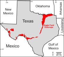
The Eagle Ford Group is a sedimentary rock formation deposited during the Cenomanian and Turonian ages of the Late Cretaceous over much of the modern-day state of Texas. The Eagle Ford is predominantly composed of organic matter-rich fossiliferous marine shales and marls with interbedded thin limestones. It derives its name from outcrops on the banks of the West Fork of the Trinity River near the old community of Eagle Ford, which is now a neighborhood within the city of Dallas. The Eagle Ford outcrop belt trends from the Oklahoma-Texas border southward to San Antonio, westward to the Rio Grande, Big Bend National Park, and the Quitman Mountains of West Texas. It also occurs in the subsurface of East Texas and South Texas, where it is the source rock for oil found in the Woodbine, Austin Chalk, and the Buda Limestone, and is produced unconventionally in South Texas and the "Eaglebine" play of East Texas. The Eagle Ford was one of the most actively drilled targets for unconventional oil and gas in the United States in 2010, but its output had dropped sharply by 2015. By the summer of 2016, Eagle Ford spending had dropped by two-thirds from $30 billion in 2014 to $10 billion, according to an analysis from the research firm Wood Mackenzie. This strike has been the hardest hit of any oil fields in the world. The spending was, however, expected to increase to $11.6 billion in 2017. A full recovery is not expected any time soon.
The Thermopolis Shale is a geologic formation which formed in west-central North America in the Albian age of the Late Cretaceous period. Surface outcroppings occur in central Canada, and the U.S. states of Montana and Wyoming. The rock formation was laid down over about 7 million years by sediment flowing into the Western Interior Seaway. The formation's boundaries and members are not well-defined by geologists, which has led to different definitions of the formation. Some geologists conclude the formation should not have a designation independent of the formations above and below it. A range of invertebrate and small and large vertebrate fossils and coprolites are found in the formation.
The Atarque Sandstone is a geologic formation in New Mexico. It preserves fossils dating back to the late Cretaceous period.

The Blood Reserve Formation, also known as the Blood Reserve Sandstone, is a geologic formation of Late Cretaceous (Campanian) age in the Western Canada Sedimentary Basin. It is present in southwestern Alberta, Canada, and was named for Blood Indian Reserve No. 148 by L.S. Russell in 1932. It is an aquifer and a source of fresh groundwater.

Juana Lopez refers to both the uppermost member of the Carlile Shale formation and to the environment that caused it to form. The Juana Lopez Member is calcareous sandstone dated to the Turonian age of the Upper Cretaceous and is exposed in the southern and western Colorado, northern and central New Mexico, and northeastern Utah. The unit has been described as "the most enigmatic" member of the Carlile Shale.