
Lake of the Woods County is a county in the northwestern part of the U.S. state of Minnesota. As of the 2020 census, the population was 3,763, making it the second-least populous county in Minnesota. Its county seat is Baudette.

Koochiching County is a county in the U.S. state of Minnesota. As of the 2020 census, the population was 12,062. Its county seat is International Falls. A portion of the Bois Forte Indian Reservation is in the county. A small part of Voyageurs National Park extends into its boundary, with Lake of the Woods County to its northwest.
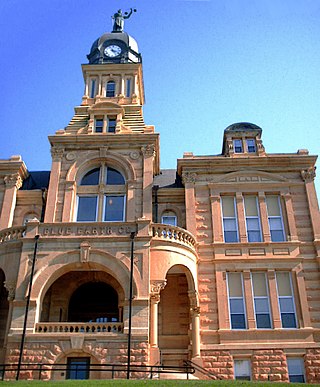
Blue Earth County is a county in the State of Minnesota. As of the 2020 census, the population was 69,112. Its county seat is Mankato. The county is named for the Blue Earth River and for the deposits of blue-green clay once evident along the banks of the Blue Earth River. Blue Earth County is part of the Mankato-North Mankato metropolitan area.

Beltrami County is a county in the northern part of the U.S. state of Minnesota. As of the 2020 census, the population was 46,228. Its county seat is Bemidji. The county's name comes from Italian adventurer Giacomo Beltrami from Bergamo, who explored the area in 1825. The county was created in 1866 and organized in 1896.

Ponemah is a census-designated place (CDP) within the Lower Red Lake unorganized territory in Beltrami County, Minnesota, United States. The population was 724 at the 2010 census.
Waskish Township is a township in Beltrami County, Minnesota, United States. The population was 116 as of the 2000 census, primarily in the community of Waskish. The community is notable as the only settlement on either Upper or Lower Red Lake not within the boundaries of Red Lake Indian Reservation.
Rulien Township is a township in Lake of the Woods County, Minnesota United States. As of the 2000 census, the township had a total population of three.

Williams is a city in Lake of the Woods County, Minnesota, United States. The population was 191 at the 2010 census.

Warroad is a city in Roseau County, Minnesota, United States, at the southwest corner of Lake of the Woods, 7.5 miles (12.1 km) south of Canada. The population was 1,781 at the 2010 census. Warroad had its own newspaper before it was incorporated in 1901.

Mahtomedi is a city in Washington County, Minnesota, United States. The population was 7,676 at the 2010 census. Mahtomedi is a suburb of St. Paul and is located between St. Paul and Stillwater.
Township 157-30 is a township in Lake of the Woods County, Minnesota, United States. The 2010 census population was one.

The Northwest Angle, known simply as the Angle by locals, and coextensive with Angle Township, is a pene-exclave of northern Lake of the Woods County, Minnesota. Except for surveying errors, it is the only place in the contiguous United States north of the 49th parallel, which forms the border between the U.S. and Canada from the Northwest Angle westward to the Strait of Georgia. The land area of the Angle is separated from the rest of Minnesota by Lake of the Woods, but shares a land border with Canada. It is one of six non-island locations in the 48 contiguous states that are practical exclaves of the U.S. It is the northernmost township in Minnesota and contains the northernmost point in the contiguous 48 states. The unincorporated community of Angle Inlet is in the Northwest Angle.

Lake of the Woods is a lake occupying parts of the Canadian provinces of Ontario and Manitoba and the U.S. state of Minnesota. Lake of the Woods is over 70 miles (110 km) long and wide, containing more than 14,552 islands and 65,000 miles (105,000 km) of shoreline. It is fed by the Rainy River, Shoal Lake, Kakagi Lake and other smaller rivers. The lake drains into the Winnipeg River and then into Lake Winnipeg. Ultimately, its outflow goes north through the Nelson River to Hudson Bay.
Oak Island, Minnesota is an island and unincorporated community in Lake of the Woods, in Lake of the Woods County, Minnesota, United States, on the Minnesota/Ontario border. It is part of Angle Township. The ZIP Code for Oak Island is 56741.

The Leech Lake Reservation is an Indian reservation located in the north-central Minnesota counties of Cass, Itasca, Beltrami, and Hubbard. The reservation forms the land base for the federally recognized Leech Lake Band of Ojibwe, one of six bands comprising the Minnesota Chippewa Tribe, organized in 1934. The Leech Lake Reservation has the second highest population of any reservation in Minnesota with White Earth Nation being the largest Minnesota Ojibwe tribe, Leech Lake Nation has a resident population of 11,388 indicated by the 2020 census.
The Baudette River is a short tributary of the Rainy River in northern Minnesota in the United States. Via the Rainy River, Lake of the Woods, the Winnipeg River, Lake Winnipeg and the Nelson River, it is part of the Hudson Bay watershed. It drains a flat region which was a prehistoric lake bed of glacial Lake Agassiz.
Crane Lake Township is a township in Saint Louis County, Minnesota, United States. The township was organized on June 18, 2002. It had a population of 82 at the 2010 census.
Pitt is a ghost town in Lake of the Woods County, Minnesota, United States.
The Baudette fire, also known as the Spooner–Baudette fire, was a large wildfire on October 7, 1910 that burned 1,200 to 1,450 square kilometres in Beltrami County, Minnesota, including nearly all of the twin towns of Spooner and Baudette. The fire also burned the villages of Graceton, Pitt, Williams, and Cedar Spur, Minnesota. Damage was horrific yet less so in the communities of Zipple, Roosevelt, Swift and Warroad in the U.S. and Stratton, Pinewood, Rainy River, and Sprague across the river in Canada, which also suffered losses. The Town of Rainy River lost its lumber mill, but saved many of the residents of Baudette and Spooner since the residential area was not affected. Their American friends were welcomed into homes where they remained for a very long time as their homes had to be rebuilt, creating a strong bond between the two communities.
Lude was an unincorporated community in Lake of the Woods County, Minnesota, United States.
