Laleston

Last updated

Laleston
Great House Hotel, Laleston. - geograph.org.uk - 1471034.jpg
Great House Hotel, Laleston
Bridgend UK location map.svg
Red pog.svg
Laleston
Location within Bridgend
Population12,586 (2011) [1]
OS grid reference SS874796
Community
  • Laleston
Principal area
Preserved county
Country Wales
Sovereign state United Kingdom
Post town BRIDGEND
Postcode district CF31
Postcode district CF32
Dialling code 01656
Police South Wales
Fire South Wales
Ambulance Welsh
UK Parliament
Senedd Cymru – Welsh Parliament
List of places
UK
Wales
Bridgend
51°30′17″N3°37′21″W / 51.504753°N 3.622590°W / 51.504753; -3.622590 Coordinates: 51°30′17″N3°37′21″W / 51.504753°N 3.622590°W / 51.504753; -3.622590

Laleston is a village and a community in Bridgend County Borough, south Wales, directly west of Bridgend town centre. The village takes its name from the Norman Lageles family who settled in the area. Buildings of note in the village include St David's Church, which still possesses features dating back to the 13th and 14th centuries, the Great House which was built in the early 16th century and Horeb Welsh Presbyterian Church (1831).

Contents

As a community, Laleston includes the areas of Bryntirion, Cefn Glas, Tythegston and Broadlands. The boundaries of the community are almost entirely set by transportation routes, with the western and north western border defined by the M4 motorway, where it then turns south-easterly at Stormy Down following the A48 back towards Bridgend town centre. It then takes in the Greenfields area, briefly following the banks of the River Ogmore, before heading north to Cefn Glas, but skirting Bridgend town centre and Newcastle. At the 2001 census, the community's population was 8,475, [2] increasing to 12,586 at the 2011 Census, a 48.5% increase.

Buildings of note

The village of Laleston has several buildings of features of note. Clustered around the church, the village has several cottages and one larger house still recognisable as 16th century design. [3] The Great House (Grade II), now a hotel, has its origins set in the 16th century, though the southern half of the building is more likely an additional 17th century build.

St David's Church is located in the centre of the village. It shows 13th and 14th century designs, though much work has been carried out since its earliest period. The church is standard in plan with a west tower, nave and lower chancel, but the tower interior is in the Perpendicular Gothic style. A restoration of 1871 saw all the original windows replaced, and this work was completed by John Prichard, more famous for his restoration of Llandaff Cathedral. There are several rustic tablets in the church from c. 1700. [3] The Church of St David is now a Grade I Listed building, while the churchyard cross is Grade II. [4]

Also of note is Horeb Welsh Presbyterian Church (Grade II), of a long-wall facade style with two tall windows in the centre, flanked by two doors, unusual for the 1831 build. While the Laleston Inn (Grade II) on Wind Street is the only building in Glamorgan from this period designed with two serving areas on the lower level. [3]

To the north of Laleston is the field of Cae'rheneglwys, where the remains of the church once dedicated to St Cewydd, who was the Welsh equivalent of St Swithin. [2]

Governance

At the local level, Laleston Community Council comprises 13 community councillors, with a Laleston/Bryntirion ward electing five of them. [5]

Prior to April 1996 Laleston was the name of an electoral ward to Ogwr Borough Council, electing three councillors. [6] It also elected a county councillor to Mid Glamorgan County Council. [7] Subsequent to the creation of Bridgend County Borough, Laleston was covered by the Laleston/Merthyr Mawr ward then, from 1999, by the Bryntirion, Laleston and Merthyr Mawr ward. Two county councillors are elected to the county borough council. [8]

Notable residents (past and present)

Related Research Articles

<span class="mw-page-title-main">Bridgend County Borough</span> County borough in Wales

Bridgend County Borough is a county borough in the south-east of Wales. The county borough has a total population of 139,200 people, and contains the town of Bridgend, after which it is named. Its members of the Senedd are Sarah Murphy MS, representing the Bridgend Constituency, and Huw Irranca-Davies MS representing the Ogmore Constituency, and its members of the UK parliament are Jamie Wallis and Chris Elmore.

<span class="mw-page-title-main">Ogwr</span> Former district of Mid Glamorgan, Wales

The Borough of Ogwr was one of six districts of Mid Glamorgan in Wales, which existed from 1974 to 1996.

<span class="mw-page-title-main">Llangynwyd</span> Village in Wales

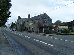
Llangynwyd is a village 2 miles to the south of Maesteg, in the county borough of Bridgend, Wales. It was part of the medieval commote of Tir Iarll.

<span class="mw-page-title-main">Bridgend (UK Parliament constituency)</span> Parliamentary constituency in the United Kingdom, 1983 onwards

Bridgend is a constituency represented in the House of Commons of the UK Parliament since 2019 by Jamie Wallis, a Conservative.

<span class="mw-page-title-main">Vaynor</span>

Vaynor is a village and community in Merthyr Tydfil County Borough in Wales, United Kingdom. The population of the community at the 2011 census was 3,551.

<span class="mw-page-title-main">St Brides Major</span> Human settlement in Wales

St. Brides Major is a village within the community also called St Brides Major in the Vale of Glamorgan in Wales.

Cefn Glas is an area on the northwestern outskirts of the town of Bridgend, Wales. It is part of the community of Laleston.

<span class="mw-page-title-main">Bridgend County Borough Council</span> Local government of Bridgend County Borough, Wales

Bridgend County Borough Council is the governing body for Bridgend County Borough, one of the Principal Areas of Wales.

<span class="mw-page-title-main">Gilfach Goch</span> Human settlement in Wales

Gilfach Goch is a community, electoral ward and small former coal mining village mostly in the Borough of Rhondda Cynon Taf, south Wales, near the larger community of Tonyrefail. Some areas in the North Western part of the village lie within Bridgend County Borough. It is situated in the Cwm Ogwr Fach between the Cwm Ogwr Fawr to the west and the Cwm Rhondda to the east.

Cornelly is a community and electoral ward in Bridgend County Borough, South Wales. As of 2011 the population of the Cornelly ward was 7,059.

Coity Higher is a community in Bridgend County Borough, south Wales. It contains the north western suburbs of Bridgend which includes the villages of Litchard and Coity. The southern boundary of the community adjoins the community of Brackla, while the northern border is defined by the M4 motorway. Notable buildings and landmarks within the community include Coity Castle, Parc Prison, the 14th century Church of St Mary, Pendre Hospital, Ty Mawr House and a burial chamber. At the 2001 census, the community's population was 835, being re-measured at 6,078 t the 2011 Census.

<span class="mw-page-title-main">Coity</span> Human settlement in Wales

Coity is a village in Bridgend County Borough, south Wales, part of Bridgend town urban area. Coity is part of the community of Coity Higher and is notable for being home to Coity Castle, one of the best preserved castles in Glamorgan. Other buildings of note in the village include St Mary, a 14th-century church, and Ty Mawr, a fine 16th-century house.

Newcastle Higher is a community in Bridgend County Borough, south Wales. Located north west of Bridgend town centre it is made up of the townships of Pen-y-fai and Aberkenfig and straddles the M4 motorway. The community is home to several notable buildings, including the Pen-y-fai Hospital, Court Coleman and All Saints Church.

<span class="mw-page-title-main">Newcastle, Bridgend</span>

Newcastle is an area and electoral ward of the town of Bridgend, Wales. The area includes the medieval Newcastle Castle. The ward elects councillors to Bridgend Town Council and Bridgend County Borough Council.

The first election to the Bridgend County Borough Council was held on 4 May 1995. It was followed by the 1999 election. On the same day there were elections to the other 21 local authorities in Wales and community councils in Wales.

Bryntirion, Laleston & Merthyr Mawr is one of the larger electoral wards of Bridgend County Borough, Wales. It covers the community of Merthyr Mawr and most of the neighbouring community of Laleston, which includes the village of the same name and the Bridgend suburb of Bryntirion. The ward elects two county councillors to the Bridgend County Borough Council.

Maesteg East is the name of an electoral ward in Bridgend County Borough, Wales. It covers part of the town of Maesteg. The ward elects two councillors to Bridgend County Borough Council.

Caerau is the name of an electoral ward in Bridgend County Borough, Wales. It covers part of the town of Maesteg. The ward elects two councillors to Bridgend County Borough Council.

References

  1. "Community population 2011" . Retrieved 7 November 2015.
  2. 1 2 Davies, John; Jenkins, Nigel; Menna, Baines; Lynch, Peredur I., eds. (2008). The Welsh Academy Encyclopaedia of Wales. Cardiff: University of Wales Press. p. 444. ISBN   978-0-7083-1953-6.
  3. 1 2 3 Newman, John (1995). Glamorgan. London: Penguin Group. pp. 369–370. ISBN   0140710566.
  4. "Buildings of Special Architectural or Historical Interest". Laleston Community Council. Archived from the original on 3 August 2012. Retrieved 14 May 2012.
  5. "Home". Laleston Community Council. Retrieved 26 July 2019.
  6. "Ogwr Welsh District Council Election Results 1973-1991" (PDF). The Elections Centre (Plymouth University). Retrieved 26 July 2019.
  7. "Mid Glamorgan County Council Election Results 1973-1993" (PDF). The Elections Centre (Plymouth University). Retrieved 26 July 2019.
  8. "Bridgend County Borough Council Election Results 1995-2012" (PDF). The Elections Centre (Plymouth University). Retrieved 26 July 2019.