Cimarron is a novel by Edna Ferber, published in April 1930 and based on development in Oklahoma after the Land Rush. The book was adapted into a critically acclaimed film of the same name, released in 1931 through RKO Pictures. The story was again adapted for the screen by Metro-Goldwyn-Mayer and was released in 1960, to meager success.

Indian Territory and the Indian Territories are terms that generally described an evolving land area set aside by the United States government for the relocation of Native Americans who held original Indian title to their land as a sovereign independent state. The concept of an Indian territory was an outcome of the U.S. federal government's 18th- and 19th-century policy of Indian removal. After the American Civil War (1861–1865), the policy of the U.S. government was one of assimilation.
Woods County is a county located in the northwestern part of the U.S. state of Oklahoma. As of the 2020 census, the population was 8,624. Its county seat is Alva. The county is named after Samuel Newitt Wood, a renowned Kansas populist.

Noble County is located in the north central part of Oklahoma. As of the 2020 census, the population was 10,924. Its county seat is Perry. It was part of the Cherokee Outlet in Indian Territory until Oklahoma Territory was created in 1890, and the present county land was designated as County P. After the U. S. government opened the area to non-Indian settlement in 1893, it was renamed Noble County for John Willock Noble, then the United States Secretary of the Interior.

Newkirk is a city and county seat of Kay County, Oklahoma, United States. The population was 2,172 at the 2020 census.
A land run or land rush was an event in which previously restricted land of the United States was opened to homestead on a first-arrival basis. Lands were opened and sold first-come or by bid, or won by lottery, or by means other than a run. The settlers, no matter how they acquired occupancy, purchased the land from the United States Land Office. For former Indian lands, the Land Office distributed the sales funds to the various tribal entities, according to previously negotiated terms. The Oklahoma Land Rush of 1889 was the most prominent of the land runs while the Land Run of 1893 was the largest. The opening of the former Kickapoo area in 1895 was the last use of a land run in the present area of Oklahoma.

The Territory of Oklahoma was an organized incorporated territory of the United States that existed from May 2, 1890, until November 16, 1907, when it was joined with the Indian Territory under a new constitution and admitted to the Union as the state of Oklahoma.
Sooners is the name given to settlers who entered the Unassigned Lands in what is now the state of Oklahoma before the official start of the Land Rush of 1889. The Unassigned Lands were a part of Indian Territory that, after a lobbying campaign, were to be opened to American settlement in 1889. President Benjamin Harrison officially proclaimed the Unassigned Lands open to settlement on April 22, 1889. As people lined up around the borders of the Oklahoma District, they waited for the official opening. It was not until noon that it officially was opened to settlement. The name derived from the "sooner clause" of Proclamation 288 — Opening to Settlement Certain Lands in the Indian Territory, which stated that anyone who entered and occupied the land prior to the opening time would be denied the right to claim land.
The American Dawes Commission, named for its first chairman Henry L. Dawes, was authorized under a rider to an Indian Office appropriation bill, March 3, 1893. Its purpose was to convince the Five Civilized Tribes to agree to cede tribal title of Indian lands, and adopt the policy of dividing tribal lands into individual allotments that was enacted for other tribes as the Dawes Act of 1887. In November 1893, President Grover Cleveland appointed Dawes as chairman, and Meridith H. Kidd and Archibald S. McKennon as members.

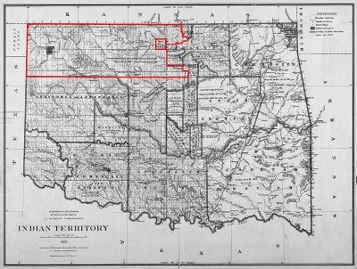
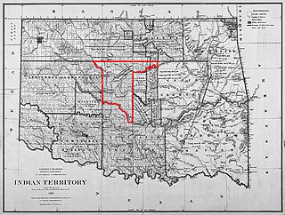
The Cherokee Outlet, or Cherokee Strip, was located in what is now the state of Oklahoma in the United States. It was a 60-mile-wide (97 km) parcel of land south of the Oklahoma-Kansas border between 96 and 100°W. The Cherokee Outlet was created in 1836. The United States forced the Cherokee Nation of Indians to cede to the United States all lands east of the Mississippi River in exchange for a reservation and an "outlet" in Indian Territory. At the time of its creation, the Cherokee Outlet was about 225 miles (360 km) long. The cities of Enid, Woodward, Ponca City, and Perry were later founded within the boundaries of what had been the Cherokee Outlet.
The Unassigned Lands in Oklahoma were in the center of the lands ceded to the United States by the Creek (Muskogee) and Seminole Indians following the Civil War and on which no other tribes had been settled. By 1883, it was bounded by the Cherokee Outlet on the north, several relocated Indian reservations on the east, the Chickasaw lands on the south, and the Cheyenne-Arapaho reserve on the west. The area amounted to 1,887,796.47 acres.
The Oklahoma Panhandle is a salient in the extreme northwestern region of the U.S. state of Oklahoma, consisting of Cimarron County, Texas County and Beaver County, from west to east. As with other salients in the United States, its name comes from the similarity of its shape to the handle of a pan.
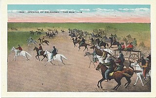
The Oklahoma Land Rush of 1889 was the first land run into the Unassigned Lands of former Indian Territory, which had earlier been assigned to the Creek and Seminole peoples. The area that was opened to settlement included all or part of Canadian, Cleveland, Kingfisher, Logan, Oklahoma, and Payne counties of the present-day US state of Oklahoma.

Tumbleweeds is a 1925 American silent Western film starring and produced by William S. Hart. It depicts the Cherokee Strip land rush of 1893. The film is said to have influenced the Oscar-winning 1931 Western Cimarron, which also depicts the land rush. The 1939 Astor Pictures' re-release of Tumbleweeds includes an 8-minute introduction by the then 75-year-old Hart as he talks about his career and the "glories of the old west." Tumbleweeds was Hart's last movie.
The Land Run of 1891 was a set of horse races to settle land acquired by the federal government through the opening of several small Indian reservations in Oklahoma Territory. The race involved approximately 20,000 homesteaders, who gathered to stake their claims on 6,097 plots, of 160 acres (0.65 km2) each, of former reservation land.

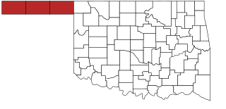
Northwestern Oklahoma is the geographical region of the state of Oklahoma which includes the Oklahoma Panhandle and a majority of the Cherokee Outlet, stretching to an eastern extent along Interstate 35, and its southern extent along the Canadian River to Noble County. Northwest Oklahoma is also known by its Oklahoma Department of Tourism designation, Red Carpet Country, which is named after the region's red soil and alludes to the metaphor that the panhandle is a "red carpet" into Oklahoma. The region consists of Cimarron, Texas, Beaver, Harper, Woods, Alfalfa, Grant, Kay, Ellis, Woodward, Major, Garfield, Noble, Dewey, Blaine, and Kingfisher counties.

The Cherokee Strip Regional Heritage Center (CSRHC) is a museum in Enid, Oklahoma, that focuses on the history of the Cherokee Outlet and the Land Run of September 16, 1893. Previously named the Museum of the Cherokee Strip, the museum has undergone renovations expanding the museum space to 24,000 square feet. The Cherokee Strip Regional Heritage Center is home to permanent and temporary exhibit galleries, a research center, and the Humphrey Heritage Village.

William Lewis Couch, a native of North Carolina and later a resident of Kansas, was best known as a leader of the Boomer Movement and as the first provisional mayor of what became Oklahoma City, Oklahoma. He joined the Boomer Movement in 1880 and became the sole leader of the movement after David L. Payne's death on November 28, 1884. He participated in the Oklahoma Land Run on April 22, 1889, and was elected provisional mayor soon thereafter on April 26, 1889. He remained mayor until November 11, 1889. On April 4, 1890, he was shot by J. C. Adams in a dispute over his homestead claim, and died on April 21, 1890.

An Organic Act is a generic name for a statute used by the United States Congress to describe a territory, in anticipation of being admitted to the Union as a state. Because of Oklahoma's unique history an explanation of the Oklahoma Organic Act needs a historic perspective. In general, the Oklahoma Organic Act may be viewed as one of a series of legislative acts, from the time of Reconstruction, enacted by Congress in preparation for the creation of a united State of Oklahoma. The Organic Act created Oklahoma Territory, and Indian Territory that were Organized incorporated territories of the United States out of the old "unorganized" Indian Territory. The Oklahoma Organic Act was one of several acts whose intent was the assimilation of the tribes in Oklahoma and Indian Territories through the elimination of tribes' communal ownership of property.

Alva is a city in and the county seat of Woods County, Oklahoma, United States, along the Salt Fork Arkansas River. The population was 4,945 at the 2010 census. Northwestern Oklahoma State University is located in Alva.