Because Cyprus has no working railway system, various other methods of transport are needed to ensure the proper delivery of any cargo, be it human or freight. Since the last railway was dismantled in 1952, the only remaining modes of transport are by road, by sea, and by air.

The Gulf of Saint Lawrence is the outlet of the North American Great Lakes via the Saint Lawrence River into the Atlantic Ocean. The gulf is a semi-enclosed sea, covering an area of about 226,000 square kilometres (87,000 sq mi) and containing about 34,500 cubic kilometres (8,300 cu mi) of water, which results in an average depth of 152 metres (499 ft).
This is a list of the extreme points of Ireland – the points that are farthest north, south, east or west in Ireland. It includes the Republic of Ireland and Northern Ireland.
Trenčín District is a district in the Trenčín Region of northwestern Slovakia. It borders the districts of Bánovce nad Bebravou, Nové Mesto nad Váhom, and Ilava. In the northwest, the Slovak state border also forms the border of the Trenčín district.
Walfisch is an uninhabited German island, in the Bay of Mecklenburg in the Baltic Sea.

Bogø is a Danish island in the Baltic Sea, just west of Møn. The population is 1,176 with 937 living in the only town on the island, Bogø By. The island is approximately 7 km long by 3 km wide at the largest points, with a total area of 13 km². Maximum height above sea level is 32 metres.
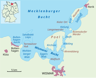
The Bay of Wismar or more commonly Wismar Bay or Wismarbucht is a well sheltered multi-sectioned bay in the southwestern Baltic Sea, in Mecklenburg-Vorpommern, Germany, and is considered the south-central part of the much larger arm of the Baltic known as the Mecklenburg Bay —a long fingerlike gulf oriented to the west-southwest (WSW) from the (central) Baltic proper. Wismar bay is considered one of the finest natural harbors on the Baltic, and served as the destination for much seaborne shipping until circa the 1910s when its minimum depths of 5 meters (16 ft) became too shallow for larger more modern ships. Today, because of the shallow sheltered waters the bay is the subject of much research via underwater archeology
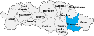
Vyšné Ladičkovce is a village and municipality in Humenné District in the Prešov Region of north-east Slovakia.

This is a list of the extreme points of the Philippines, the points that are farther north, south, east or west than any other location in the country. According to Republic Act 9522 of 2009, which defined the archipelagic baselines of the Philippines, identifies the extreme points of the Philippines under Section 1.
Ainley Peak is a prominent peak, 1,240 metres (4,070 ft) high, located 3 miles (5 km) southwest of Post Office Hill in east Ross Island. Named after David G. Ainley, Point Reyes Bird Observatory, Stinson Beach, California, a United States Antarctic Program ornithologist who studied penguin and skua populations at Cape Crozier and McMurdo Sound in six seasons, 1969–70 to 1983–84.

The Zeppelin LZ 13 Hansa was a German civilian rigid airship first flown in 1912. It was built for DELAG to carry passengers and post and flew the first international passenger flight, visiting Denmark and Sweden in September 1912. In 1913 it was hired to the Imperial German Navy as a training craft, and at the outbreak of World War I it was requisitioned by the German military who used it for bombing, reconnaissance, and finally as a training airship.
The Kyle Hills are a prominent group of volcanic cones, hills, ridges, and peaks that occupy the eastern part of Ross Island, Antarctica, between Mount Terror and Cape Crozier. The hills extend east–west for 8 nautical miles (15 km), rising from sea level at Cape Crozier to about 2,600 metres (8,500 ft) in Mount McIntosh at the western end of the group. Local relief of features is on the order of 200 metres (660 ft).

The borders of the oceans are the limits of Earth's oceanic waters. The definition and number of oceans can vary depending on the adopted criteria.

Jubilee Peak is a peak rising to about 500 metres (1,600 ft) at the north end of Clarence Island, west of Cape Lloyd, in the South Shetland Islands. Following the ascent of the peak by a JSEEIG party, February 2, 1977, it was named by the UK Antarctic Place-Names Committee in honor of the Silver Jubilee year of Her Majesty Queen Elizabeth II.
The Breitling is a narrow strait in the Baltic Sea between the island of Poel and the mainland in the northeast of the district of Nordwestmecklenburg. It links the sheltered part of the Bay of Wismar, beginning south of Poeldamm, with the Salzhaff.
Kehdingen was a fishing trawler that was built in 1929 as Volkswohl. She was renamed Kehdingen in 1938 and was requisitioned by the Kriegsmarine in 1939. She served until 1944 when she was scuttled of the east coast of Greenland.

Yediadalar is the name of a group of small islands of Turkey. They are Aegean islands in the Gökova bay. Administratevly, they are a part of Marmaris ilçe (district) of Muğla Province at 36°52′N28°02′E. They are uninhabited.

