Las Tunas Province

Last updated
Las Tunas Province
Coat of Arms of the city of Las Tunas, Cuba.svg
Las Tunas in Cuba.svg
Country Cuba
Capital Las Tunas
Government
  PresidentJaime Ernesto Chiang Vega
Area
[1]
  Total6,595.25 km2 (2,546.44 sq mi)
Population
 (2021-12-31)
  Total528,853
  Density80/km2 (210/sq mi)
Time zone UTC-5 (EST)
Area code +53-31
HDI (2019)0.755 [2]
high · 16th of 16
Website https://www.lastunas.gob.cu/es/

Las Tunas is one of the provinces of Cuba. Major towns include Puerto Padre, Amancio, and the capital city, Las Tunas (historically Victoria de Las Tunas). [3]

Contents

Climate and agriculture

The southern coast, which opens onto the Gulf of Guacanayabo, is marshy and characterised by mangroves. This wet area is used to grow sugarcane, as the wet climate is well suited for the crop.

Cattle are also grazed in the province.

History

Las Tunas was part of the Oriente province, until that province was divided into five smaller provinces in 1975.

In the same year, a large development program was started to modernize the town of Las Tunas and connect it by road to Havana.[ citation needed ]

Municipalities

Municipality Population
(2022) [4]
Area
(km²)
LocationRemarks
Amancio 36,132857 20°49′11″N77°35′3″W / 20.81972°N 77.58417°W / 20.81972; -77.58417 (Amancio)
Colombia 31,482563 20°59′27″N77°24′57″W / 20.99083°N 77.41583°W / 20.99083; -77.41583 (Colombia)
Jesús Menéndez 46,729638 21°09′49″N76°28′38″W / 21.16361°N 76.47722°W / 21.16361; -76.47722 (Jesús Menéndez)
Jobabo 40,345884 20°54′29″N77°16′59″W / 20.90806°N 77.28306°W / 20.90806; -77.28306 (Jobabo)
Las Tunas 214,939891 20°57′36″N76°57′16″W / 20.96000°N 76.95444°W / 20.96000; -76.95444 (Las Tunas) Provincial capital
Majibacoa 40,235621 20°55′2″N76°52′34″W / 20.91722°N 76.87611°W / 20.91722; -76.87611 (Calixto) Calixto
Manatí 28,773953 21°18′53″N76°56′15″W / 21.31472°N 76.93750°W / 21.31472; -76.93750 (Manatí)
Puerto Padre 90,2181,178 21°11′43″N76°36′5″W / 21.19528°N 76.60139°W / 21.19528; -76.60139 (Puerto Padre)
Sources: Population from 2004 Census. [5] Area from 1976 municipal re-distribution. [6]
Map all coordinates using: OpenStreetMap

Demographics

In 2004, the province of Las Tunas had a population of 529,850. [5] With a total area of 6,587.75 km2 (2,543.54 sq mi), [7] the province had a population density of 80.4/km2 (208/sq mi).

See also

Related Research Articles

<span class="mw-page-title-main">Provinces of Cuba</span> Administrative divisions of Cuba

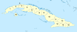
Administratively, Cuba is divided into 15 provinces and one special municipality. The current structure has been in place since August 2010, when the then-La Habana Province was divided into Artemisa Province and Mayabeque Province.

<span class="mw-page-title-main">Santiago de Cuba Province</span> Province of Cuba

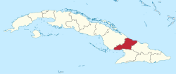
Santiago de Cuba Province is the second most populated province in the island of Cuba. The largest city Santiago de Cuba is the main administrative center. Other large cities include Palma Soriano, Contramaestre, San Luis and Songo-la Maya.

<span class="mw-page-title-main">Villa Clara Province</span> Province of Cuba

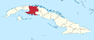
Villa Clara is one of the provinces of Cuba. It is located in the central region of the island bordering on the Atlantic Ocean to the north, Matanzas Province to the west, Sancti Spiritus Province to the east, and Cienfuegos Province to the South. Villa Clara shares with Cienfuegos and Sancti Spiritus on the south the Escambray Mountain Range. Its main cities are Santa Clara, Remedios, Sagua La Grande, Camajuani, Caibarién, Ranchuelo, Placetas, and Manicaragua.

<span class="mw-page-title-main">Pinar del Río Province</span> Province of Cuba

The Pinar del Río Province is one of the 15 provinces of Cuba. It is at the western end of the island of Cuba. The capital and largest city is Pinar del Río.

<span class="mw-page-title-main">Matanzas Province</span> Province of Cuba

Matanzas is one of the provinces of Cuba. Major towns in the province include Cárdenas, Colón, Jovellanos and the capital of the same name, Matanzas. The resort town of Varadero is also located in this province.

<span class="mw-page-title-main">Cienfuegos Province</span> Province of Cuba

Cienfuegos is one of the provinces of Cuba. The capital city of the province is also called Cienfuegos and was founded by French settlers in 1819.

<span class="mw-page-title-main">Sancti Spíritus Province</span> Province of Cuba

Sancti Spíritus is one of the provinces of Cuba. Its capital is the identically named Sancti Spíritus. Another major city is Trinidad.

<span class="mw-page-title-main">Ciego de Ávila Province</span> Province of Cuba

Ciego de Ávila is one of the provinces of Cuba, and was previously part of Camagüey Province. Its capital is Ciego de Ávila, which lies on the Carretera Central, and the second city is Morón, further north.

<span class="mw-page-title-main">Holguín Province</span> Province of Cuba

Holguín is one of the provinces of Cuba, the third most populous after Havana and Santiago de Cuba. It lies in the southeast of the country. Its major cities include Holguín, Banes, Antilla, Mayarí, and Moa.

<span class="mw-page-title-main">Granma Province</span> Province of Cuba

Granma is one of the provinces of Cuba. Its capital is Bayamo. Other towns include Manzanillo and Pilón.

<span class="mw-page-title-main">Manzanillo, Cuba</span> Municipality in Granma, Cuba

Manzanillo is a municipality and city in the Granma Province of Cuba. By population, it is the 14th-largest Cuban city and the most populated one not being a provincial seat.

<span class="mw-page-title-main">Las Tunas (city)</span> Municipality in Las Tunas, Cuba

Las Tunas is a city and municipality in central-eastern Cuba. It is the capital of the Las Tunas Province and was named Victoria de Las Tunas from 1869 to 1976.

<span class="mw-page-title-main">Guáimaro</span> Municipality in Camagüey, Cuba

Guáimaro is a town and municipality in the southern part of Camagüey Province in Cuba. It is located between the cities of Camagüey and Las Tunas.

<span class="mw-page-title-main">Campechuela</span> Municipality in Granma, Cuba

Campechuela is a municipality and town in Granma Province of Cuba. It is located on the southern shore of the Gulf of Guacanayabo.

<span class="mw-page-title-main">Guamá, Cuba</span> Municipality in Santiago de Cuba, Cuba

Guamá is a municipality in the Santiago de Cuba Province of Cuba. The municipal seat is located in the town of Chivirico. It was named after Guamá, the Taíno cacique who led a rebellion against the Spanish 1530s.

<span class="mw-page-title-main">Niquero</span> Municipality in Granma, Cuba

Niquero is a municipality and town in the Granma Province of Cuba. It is located in the coastal region of the province, bordering the Gulf of Guacanayabo. Cape Cruz, the westernmost point of the province is located in this municipality.

<span class="mw-page-title-main">Amancio, Cuba</span> Municipality in Las Tunas, Cuba

Amancio is a municipality and town in the Las Tunas Province of Cuba. It is located in the south-western part of the province, and opens to the Gulf of Guacanayabo to the south.

<span class="mw-page-title-main">Jobabo</span> Municipality in Las Tunas, Cuba

Jobabo is a municipality and town in the Las Tunas Province of Cuba. It is located in the southern part of the province, 34 km (21 mi) south of Las Tunas, the provincial capital.

<span class="mw-page-title-main">Majibacoa</span> Municipality in Las Tunas, Cuba

Majibacoa is a municipality and town in the Las Tunas Province of Cuba. The municipal seat is located in the town of Calixto, immediately east of Las Tunas, the provincial capital.

<span class="mw-page-title-main">La Habana Province (1976–2010)</span> Province in Cuba

Havana Province was one of the provinces of Cuba from 1976, when the nation's provincial structure was revised, through the end of 2010. On January 1, 2011, the province was divided into two new provinces, Artemisa and Mayabeque. La Habana Province had 711,066 people in the 2002 census. The largest city was Artemisa (81,209), as the much larger city of Havana was structured in a different province, Ciudad de La Habana Province.

References

  1. "Lugar que ocupa el territorio según la superficie y la población" (PDF). Una MIRADA a Cuba (in Spanish). Oficina Nacional de Estadísticas. Cuba. 2010.
  2. "Sub-national HDI - Area Database - Global Data Lab". hdi.globaldatalab.org. Retrieved 2022-01-24.
  3. (in Spanish) Historical site of the city of Las Tunas Archived 2012-11-16 at the Wayback Machine
  4. "Las Tunas (Province, Cuba) - Population Statistics, Charts, Map and Location". www.citypopulation.de. Retrieved 2024-02-03.
  5. 1 2 Atenas.cu (2004). "2004 Population trends, by Province and Municipality" (in Spanish). Archived from the original on 2007-09-27. Retrieved 2007-10-06.
  6. Statoids (July 2003). "Municipios of Cuba" . Retrieved 2007-10-06.
  7. Government of Cuba (2002). "Population by Province" (in Spanish). Archived from the original on 2007-09-28. Retrieved 2007-10-02.