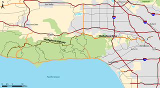
Mulholland Drive is a street and road in the eastern Santa Monica Mountains of Southern California. It is named after pioneering Los Angeles civil engineer William Mulholland. The western rural portion in Los Angeles and Ventura Counties is named Mulholland Highway. The road is featured in a significant number of films, songs, and novels. David Lynch, who wrote and directed a film named after Mulholland Drive, has said that one can feel "the history of Hollywood" on it. Jack Nicholson has lived on Mulholland Drive for many years, and still did so as of 2009.

The Santa Monica Mountains are a coastal mountain range in Southern California, next to the Pacific Ocean. It is part of the Transverse Ranges. The Santa Monica Mountains National Recreation Area encompasses this mountain range. Because of its proximity to densely populated regions, it is one of the most visited natural areas in California.

Pacific Palisades is a neighborhood in the Westside region of Los Angeles, California, situated about 20 miles (32 km) west of Downtown Los Angeles.

Topanga is an unincorporated community in western Los Angeles County, California, United States. Located in the Santa Monica Mountains, the community exists in Topanga Canyon and the surrounding hills. The narrow southern portion of Topanga at the coast is between the city of Malibu and the Los Angeles neighborhood of Pacific Palisades. As of the 2020 census the population of the Topanga CDP was 8,560. For statistical purposes, the United States Census Bureau has defined Topanga as a census-designated place (CDP). The ZIP code is 90290 and the area code is primarily 310, with 818 only at the north end of the canyon. It is in the 3rd County Supervisorial district.

The Simi Hills are a low rocky mountain range of the Transverse Ranges in eastern Ventura County and western Los Angeles County, of southern California, United States.

Ballona Creek is an 8.5-mile (13.7 km) channelized stream in southwestern Los Angeles County, California, United States, that was once a "year-round river lined with sycamores and willows". The urban watercourse begins in the Mid-City neighborhood of Los Angeles, flows through Culver City and Del Rey, and passes the Ballona Wetlands Ecological Preserve, the sailboat harbor Marina del Rey, and the small beachside community of Playa del Rey before draining into Santa Monica Bay. The Ballona Creek drainage basin carries water from the Santa Monica Mountains on the north, from the Baldwin Hills to the south, and as far as the Harbor Freeway (I-110) to the east.

Topanga State Park is a California state park located in the Santa Monica Mountains, within Los Angeles County, California. It is part of the Santa Monica Mountains National Recreation Area.
Laurel Canyon is a mountainous neighborhood in the Hollywood Hills region of the Santa Monica Mountains, within the Hollywood Hills West district of Los Angeles, California. The main thoroughfare of Laurel Canyon Boulevard connects the neighborhood with the more urbanized parts of Los Angeles to the north and south, between Ventura Boulevard and Hollywood Boulevard.
KUSC is a listener-supported classical music radio station broadcasting from downtown Los Angeles, California, United States. KUSC is owned and operated by the University of Southern California, which also operates student-run Internet station KXSC (AM) and San Francisco's classical station KDFC. It is the largest non-profit classical music station in the country and one of the two classical music stations in the Greater Los Angeles Area, KUSC and KMZT.

The Upper Las Virgenes Canyon Open Space Preserve is a large open space nature preserve owned and operated by the Santa Monica Mountains Conservancy spanning nearly 3,000 acres (1,200 ha) in the Simi Hills of western Los Angeles County and eastern Ventura County.
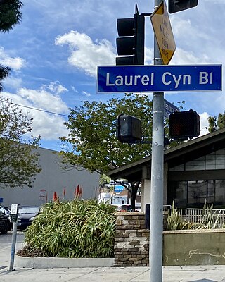
Laurel Canyon Boulevard is a major street in the city of Los Angeles. It starts off at Polk Street in Sylmar in the northern San Fernando Valley near the junction of the San Diego and the Golden State (I-5)) freeways. Laurel Canyon Boulevard bypasses the city of San Fernando to the west, running parallel to I-5 in the vicinity of Pacoima and Arleta. The portion through Sun Valley passes through rock quarries and a great deal of open space.
The western border of Santa Monica, California, is the 3-mile (4.8 km) stretch of Santa Monica Bay. On its other sides, the city is bordered by various districts of Los Angeles: the northwestern border is Pacific Palisades, the eastern border is Brentwood north of Wilshire Boulevard and West Los Angeles south of Wilshire, the northeastern border is generally San Vicente Boulevard up to the Riviera Country Club, the southwestern border is Venice Beach and the southern border is with West Los Angeles and Mar Vista.

Malibu Creek is a year-round stream in western Los Angeles County, California. It drains the southern Conejo Valley and Simi Hills, flowing south through the Santa Monica Mountains, and enters Santa Monica Bay in Malibu. The Malibu Creek watershed drains 109 square miles (280 km2) and its tributary creeks reach as high as 3,000 feet (910 m) into Ventura County. The creek's mainstem begins south of Westlake Village at the confluence of Triunfo Creek and Lobo Canyon Creek, and flows 13.4 miles (21.6 km) to Malibu Lagoon.

Mt. Olympus is a neighborhood in the Hollywood Hills area of the city of Los Angeles, California. Considered a subdistrict of Laurel Canyon, the 300-acre (120 ha) neighborhood is known for its upscale housing and wide streets. Mt. Olympus can be reached by taking Laurel Canyon Blvd. to Mt. Olympus Drive.

The Tongva Sacred Springs are a group of springs located on the campus of University High School in Los Angeles, California. The springs, called Koruuvanga by the native Gabrieleno Tongva people, were used as a source of natural fresh water by the Tongva people since at least the 5th century BC and continue to produce 22,000–25,000 US gallons (83,000–95,000 L) of water a day. The springs are also sometimes referred to as the Gabrieleno-Tongva Springs, the Tongva Holy Springs, and the Sacred Springs.

Coldwater Canyon is a canyon running perpendicular to and over the central Santa Monica Mountains, in Los Angeles County, California, United States.
Robert Lee Byrd was an architect in Los Angeles, California. Most of his buildings and residences are from the 1920s to the 1970s. In his later years he worked together with his architect son Gary Byrd. He was known for his modern "indoor–outdoor" style – along with his use of bird houses embedded in the actual structure. He also designed and built furniture.
Franklin Canyon Park is a public municipal park located near Benedict Canyon, at the eastern end of the Santa Monica Mountains, in Los Angeles, California. The park comprises 605 acres (245 ha), and is located near the geographical center of the city of Los Angeles. Franklin Canyon is also the name of the canyon and surrounding neighborhood.

The Wallis Annenberg Wildlife Crossing is a vegetated overpass spanning the Ventura Freeway and Agoura Road under construction at Liberty Canyon in Agoura Hills, California. The bridge will be one of the largest urban wildlife crossings in the world, connecting the Simi Hills and the Santa Monica Mountains over a busy freeway with ten traffic lanes, when including exit lanes.

The Old Santa Monica Forestry Station is the nation's first experimental forestry station, built in 1887. The Old Santa Monica Forestry Station was designated a California Historic Landmark (No.840) on March 20, 1970. Old Santa Monica Forestry Station is located at Rustic Canyon in Los Angeles in the Santa Monica Mountains of Southern California in Los Angeles County. The site is south of what is now called Santa Monica Mountains National Recreation Area. In 1971 the state placed a marker near the entrance of the Rustic Canyon Recreation Center at the NW corner of Latimer and Hilltree Roads, at 601 Latimer Road, Los Angeles, CA 90402. This location is in what is now called Pacific Palisades. The hills and canyons around the Santa Monica Canyon were a land boom in the late 1880s.


