Laurentian Mountains

Last updated
Laurentian Mountains
Jacques-Cartier National Park, Quebec, Canada. 004.jpg
Highest point
Peak Mont Raoul Blanchard
Elevation 1,166 m (3,825 ft)
Coordinates 47°19′N70°50′W / 47.317°N 70.833°W / 47.317; -70.833
Dimensions
Length1,448 km (900 mi)
Geography
LaurentianMountains-Range.svg
CountryCanada
Province
Range coordinates 50°28′49.17″N68°20′11.13″W / 50.4803250°N 68.3364250°W / 50.4803250; -68.3364250
Geology
Orogeny Grenville orogeny
Age of rock Precambrian
Type of rock

The Laurentian Mountains, also known as the Laurentians or Laurentides, are a mountain range in Canada. The range is 1,448 km (900 mi) long and ranges in height from 500 m (1,640 ft) with peaks over 1,000 m (3,280 ft). The Laurentian Mountains extend across Labrador and Quebec within the Laurentian Upland, which contains foothills in northeastern Ontario. The range is located near the rivers of Ottawa, St. Lawrence, and Saguenay. The Laurentian Mountains primarily stretch across multiple regions in Quebec, with geologic formations such as the Jacques-Cartier Massif located within the range.

Contents

The Laurentians Mountains are one of the oldest mountain ranges on earth. The range formed around one billion years ago during the Grenville orogeny, in which the Grenville Province formed, a subdivision of the Canadian Shield. During that time, Laurentia, the geologic core of the Canadian Shield, collided with other continents and formed Precambrian rocks which extend across the range. The mountain range is located around other related geographic features, such as the Monteregian Hills and the Adirondack Mountains.

The Laurentian Mountains are home to vast extents of boreal ecosystems and mixed forests. The southern areas of the range are dominated by black spruce and balsam fir, with areas of white birch. The range is home to various wildlife species. The Laurentian Mountains are an important part of the economy of Quebec, as they have been historically been used for forestry and provide access to tourism and outdoor recreation for people in the region.

Etymology

The namesake of the mountains is derived from the term "Laurentide" or "Laurentian", which is itself derived from the St. Lawrence River. François-Xavier Garneau, author of Histoire de Canada, was first to use the term "Laurentien" when he coined the name of the mountains in 1845. Early geologists adopted the name for the complex of metamorphic and igneous rocks in this area, with the terms further being applied to the Laurentide Ice Sheet and the Laurentian Shield (Canadian Shield). [1] [2] Garneau applied the new term to the whole range north of the St. Lawrence River. While the region has been popularly referred to as the Laurentians and Les Laurentides, it was officially adopted in 1987 as the territory was defined. [1]

Geography

View of the range from Grands-Jardins National Park Parc national des Grands-Jardins, Canada (47713652892).jpg
View of the range from Grands-Jardins National Park

The Laurentian Mountains extend from Quebec to Labrador over a distance of 1,448 kilometers (900 miles). [3] They are partially bounded by the Ottawa, St. Lawrence, and Saguenay River. The Laurentian Mountains reside in the Laurentian Upland, [4] which extends as far west as Lake Huron, [3] with foothills extending into northeastern Ontario. [3] [5] Sub-ranges in the upland are the Opeongo Hills, Misquah Hills, Huron Mountains, and the Porcupine Mountains. This region is extensively forested and contains nearly untouched wilderness, with it not being suited for agriculture. [5]

One of Quebec's official regions is called Laurentides. The mountain range runs through four other regions; Capitale-Nationale, Outaouais, Lanaudière, and Mauricie. The elevation generally ranges from around 500 m (1,640 ft) to 1,000 m (3,280 ft) with Mont Raoul-Blanchard being its highest peak, at 1,166 m (3,825 ft). Mont Tremblant, Mont Bleu, and Mont des Conscrits are other prominent peaks in the mountain range. [5] Jacques-Cartier National Park is located in this mountain range, which is north of Quebec City, residing in the Jacques-Cartier Massif. [6] The Adirondack Mountains, which are located in northeastern New York, have great similarity to the Laurentian Mountains, consisting of the same type of rocks that are part of the Canadian Shield. [7]

Geology

Laurentian Mountains, Route 138, Quebec, Canada Route 138 002.jpg
Laurentian Mountains, Route 138, Quebec, Canada

The Laurentian Mountains [8] are one of the oldest mountain ranges in the world, being of Precambrian age, with some regions dating to over one billion years old. [9] The mountain range is between other related geologic features, such as the Monteregian Hills and the older Oka Hills. [10] The mountain range is located within the Grenville orogeny. [11] The rocks of the Laurentian Mountains contain deformation and metamorphic structures that show long periods of tectonic activity occurred. The Grenville Province is a subdivision of the Canadian Shield, and in this area, the oldest rocks of this geologic region are found. These rocks represent a chain of mountains that formed between 1,500 and 900 million years ago. During that time, Laurentia, the geologic core of the Canadian Shield, collided with other continents that were dragged by moving tectonic plates. [10]

Ecology

Female moose at Jacques-Cartier National Park Alces alces PJC3.jpg
Female moose at Jacques-Cartier National Park

The Laurentian Mountains contain dense boreal forests. It is home to some deciduous trees, such as sugar maple, beech, but are rarely found past the northern boundary of the range. [12] The Laurentian region is also rich in walnut, ash, cherry, linden, and oak. [13] The range also contains bogs. The boreal ecosystem is represented by mixed forests, dominated by black spruce and balsam fir to the south, including areas of white birch. [14] Laurentides Wildlife Reserve, which is located in the range, contains mammals such as black bears, bobcats, raccoons, grey wolves, otters, moose, white-tailed deer and caribou, with birds such as the barred owl, American kestrel, and osprey. [15]

Economy

Mont-Tremblant in 2015 Mont Tremblant village.jpeg
Mont-Tremblant in 2015

Tourism

The Laurentian Mountains are a popular recreational destination in Quebec. [13] The first ski lift in North America was built in the mountain range in 1931, and by the late 1930s, "snow trains" had brought tens of thousands of skiers to the range. In the area, there is skiing, snowboarding, dog sledding, ice climbing, and snowmobiling during winter at Mont-Tremblant, with rafting, kayaking, hiking, camping, and golf through the region during spring, summer, and fall. [16]

Forestry

The Laurentian Mountains have been historically used for logging. During the European colonization of North America, colonists were met with a woodland that stretched from the East Coast to the Great Lakes. The forests reached heights of 30 to 85 meters high. While the exports of logging grew, it eventually became a wasteful practice, with the felling of trees leaving huge portions of land vulnerable to erosion. [17] Intensive forestry has not entirely ceased in the region. Public and private forests in Quebec have now been entirely mapped, with information such as the soil, terrain, and waterways, and the species and the age of the trees available. With this data, the chief forester calculates the amount of wood that can be harvested, ensuring the forest is not cut down faster than it can grow back. [13]

See also

Related Research Articles

<span class="mw-page-title-main">Canadian Shield</span> Geographic and geologic area of North America

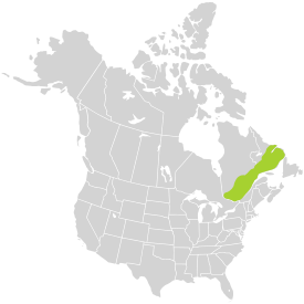
The Canadian Shield, also called the Laurentian Shield or the Laurentian Plateau, is a geologic shield, a large area of exposed Precambrian igneous and high-grade metamorphic rocks. It forms the North American Craton, the ancient geologic core of the North American continent. Glaciation has left the area with only a thin layer of soil, through which exposures of igneous bedrock resulting from its long volcanic history are frequently visible. As a deep, common, joined bedrock region in eastern and central Canada, the shield stretches north from the Great Lakes to the Arctic Ocean, covering over half of Canada and most of Greenland; it also extends south into the northern reaches of the United States.

<span class="mw-page-title-main">La Mauricie National Park</span> National park in Quebec, Canada

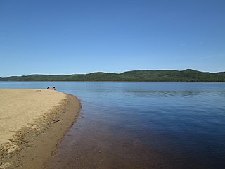
La Mauricie National Park is a national park located near Shawinigan in the Laurentian mountains, in the Mauricie region of Quebec, Canada. It covers 536 km2 (207 sq mi) in the southern Canadian Shield region bordering the Saint Lawrence lowlands. The park contains 150 lakes and many ponds.

<span class="mw-page-title-main">Torngat Mountains</span> Mountain range in eastern Canada

The Torngat Mountains are a mountain range on the Labrador Peninsula at the northern tip of Newfoundland and Labrador and eastern Quebec. They are part of the Arctic Cordillera. The mountains form a peninsula that separates Ungava Bay from the Atlantic Ocean.

<span class="mw-page-title-main">Lanaudière</span> Administrative region in Quebec, Canada

Lanaudière is one of the seventeen administrative regions of Quebec, Canada, situated immediately to the northeast of Montreal. It has a total population of 494,796 inhabitants, an increase of 4.9% over the 2011 census.

<span class="mw-page-title-main">Monteregian Hills</span> Linear chain of monadnocks in Quebec, Canada

The Monteregian Hills is a linear chain of isolated mountains in Montreal and Montérégie, between the Laurentians and the Appalachians.

<span class="mw-page-title-main">Jacques-Cartier River</span> River of Capitale-Nationale (Québec, Canada)

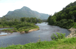
The Jacques-Cartier River is a river in the province of Quebec, Canada. It is 161 km long and its source is Jacques-Cartier Lake in Laurentides Wildlife Reserve, and flows in a predominantly southern direction before ending in the Saint Lawrence River at Donnacona, about 30 km upstream from Quebec City.

<span class="mw-page-title-main">Mont-Tremblant National Park</span> Provincial park in Quebec, Canada

Mont-Tremblant National Park is a provincial park in Canada located north of the town of Mont-Tremblant, and the village of Saint-Donat and Saint-Côme, in the administrative regions of Laurentides and Lanaudière, in Quebec, in Canada.

<span class="mw-page-title-main">Laurentian Upland</span> Province of the larger Canadian Shield physiographic division

The Laurentian Upland is a physiographic region which, when referred to as the "Laurentian Region" or the Grenville geological province, is recognized by Natural Resources Canada as one of five provinces of the larger Canadian Shield physiographic division. The United States Geological Survey recognizes the Laurentian Upland as the larger general upland area of the Canadian Shield.

<span class="mw-page-title-main">Jacques-Cartier National Park</span>

Jacques-Cartier National Park is a provincial park located 50 kilometres (31 mi) north of Quebec City. The park aims to protect wildlife in the Laurentian massif. It lies within the Eastern forest-boreal transition ecoregion.

<span class="mw-page-title-main">Laurentides Wildlife Reserve</span> Wildlife reserve in Quebec, Canada

Réserve faunique des Laurentides, also known by its former name of parc des Laurentides, is a wildlife reserve in Quebec, Canada, located between Quebec City and the Saguenay–Lac-Saint-Jean region. This reserve is part of the network of wildlife reserves of Quebec (Canada) managed by the Ministry of Energy and Natural Resources (Quebec) and the Société des établissements de plein air du Québec. It is located halfway between Saguenay and Quebec.

The zec de la Rivière-Jacques-Cartier is a "zone d'exploitation contrôlée" (zec) in the municipality of Donnacona, in the Portneuf Regional County Municipality, in the administrative area of the Capitale-Nationale, in Quebec, in Canada.

<span class="mw-page-title-main">Ecological regions of Quebec</span>

The Ecological regions of Quebec are regions with specific types of vegetation and climates as defined by the Quebec Ministry of Forests, Wildlife and Parks. Given the size of this huge province, there is wide variation from the temperate deciduous forests of the southwest to the arctic tundra of the extreme north.

<span class="mw-page-title-main">Uapishka Biodiversity Reserve</span> Protected area in Quebec, Canada

The Uapishka Biodiversity Reserve is a protected area in the Côte-Nord region of Quebec. It is one of five biodiversity reserves in the province. It is to the east of the Manicouagan Reservoir and includes a large part of the Monts Groulx. It is also part of the central area of the Manicouagan Uapishka Biosphere Reserve.

<span class="mw-page-title-main">Jacques-Cartier Lake</span>

The lac Jacques-Cartier, main source of the Jacques-Cartier River, is a glacial lake located in the Laurentides Wildlife Reserve, about 90 km to the north of the city of Quebec, in the unorganized territory of Lac-Jacques-Cartier, in the La Côte-de-Beaupré Regional County Municipality, in the administrative region of Capitale-Nationale, in the province of Quebec, in Canada.

<span class="mw-page-title-main">Sautauriski Mountain</span>

The Sautauriski mountain culminates at 727 metres (2,385 ft) in the southern part of Jacques-Cartier National Park, in the municipality of Stoneham-et-Tewkesbury, in the regional county municipality (MRC) of La Jacques-Cartier, in the administrative region of Capitale-Nationale, in Quebec, Canada.

<span class="mw-page-title-main">Andante Mount</span>

The Mont Andante culminates at 810 metres (2,660 ft) in the western part of Jacques-Cartier National Park, in the unorganized territory of Lac-Croche, in the La Jacques-Cartier Regional County Municipality, in the administrative region of Capitale-Nationale, in Quebec, Canada.

<span class="mw-page-title-main">Jacques-Cartier Massif</span>

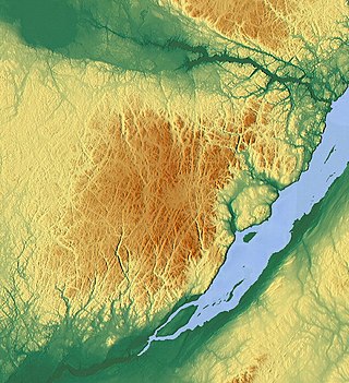
The Lac Jacques-Cartier massif is a massif and the highest mountain range of the Laurentian Mountains, in the Canadian province of Quebec. Located between the St. Lawrence River and the Saguenay Graben, the altitude of its plateau varies between 800 and 900 meters while its highest point, Mount Raoul Blanchard, reaches 1,181 metres (3,875 ft) of altitude.

The Mont Belle Fontaine, culminating at 1,151 metres (3,776 ft) of altitude, is the highest summit of the Laurentides Wildlife Reserve.

<span class="mw-page-title-main">Mont du Lac des Cygnes</span>

Mont du Lac des Cygnes is a mountain of the Jacques-Cartier Massif, located within the Grands-Jardins National Park in Quebec, Canada. Its summit culminating at 980 metres (3,220 ft) above sea level and overlooking the valley of the Rivière du Gouffre is one of the main attractions of the park.

References

  1. 1 2 Graham, Joseph (2005-11-14). Naming the Laurentians: A History of Place Names 'up North'. Les Editions Main Street. pp. 15–17. ISBN   9780973958607.
  2. Parry, John (2019-10-19) [1963-03-01]. "The Laurentians: A Study In Geomorphological Development". McGill University. McGill University. p. 5. Retrieved 2023-04-10.
  3. 1 2 3 Adams, Frank (1893). "On the Typical Laurentian Area of Canada". The Journal of Geology . 1 (4): 325–340. Bibcode:1893JG......1..325A. doi: 10.1086/606191 . JSTOR   30054299. S2CID   129323630.
  4. Government of Canada, Natural Resources Canada (2016-09-12). "Natural Resources Canada. The Atlas of Canada. Physiographic Regions of Canada". atlas.gc.ca. Retrieved 2023-04-11.
  5. 1 2 3 Walla, Rebecca; DeVo, Karinjo; Lifton-Zoline, Pamela; Lifton-Zoline, John (2012). "Sustainable Mountain Development North America Report" (PDF). Utah Valley University. Retrieved 2023-04-10.
  6. Guide de reconnaissance des types écologiques des régions écologiques 5e – Massif du lac Jacques-Cartier et 5f – Massif du mont Valin (PDF). Publications du Québec. 2004. ISBN   2-551-22455-1 . Retrieved 2023-04-10.{{cite book}}: |website= ignored (help)
  7. Farmer, G. Thomas; Cook, John (2013). Climate Change Science: A Modern Synthesis (PDF). Vol. 1: The Physical Climate. Springer. p. 335. ISBN   978-94-007-5756-1.
  8. Laurentian Mountains | Flore laurentienne, Marie-Victorin, 1935, Gallica, BNF, Fr
  9. Farmer & Cook 2013, p. 337.
  10. 1 2 "Montreal-Heritage". CGEN Archive. Retrieved 2023-04-10.
  11. Willey, Lisabeth; Jones, Michael (2012). "Ten Peaks in the Great Eastern Alpine Zone: A List of Great Mountains Expands Old Ideas of Boundaries". Dartmouth College. pp. 22–24. Retrieved 2023-04-10.
  12. "Forest sustainability in East Canada Quebec" (PDF). Laborelec . 2018. p. 17. Retrieved 2023-04-10.
  13. 1 2 3 "Sustainable Forestry Is Taking Root in Québec". beside.media. Retrieved 2023-04-11.
  14. Cross, L. D. (2004-03-01). "The Land Of The Laurentians". Legion Magazine. Retrieved 2023-04-10.
  15. "Reserve des Laurentides wildlife location in Canada, North America | Wildlife Worldwide". www.wildlifeworldwide.com. Retrieved 2023-04-10.
  16. "Laurentian Mountains". Travel. 2013-09-30. Archived from the original on April 10, 2021. Retrieved 2023-04-10.
  17. Graham 2005, pp. 118–220.