Laxton, Nottinghamshire

Last updated

Laxton
Laxton Nottinghamshire.jpg
Nottinghamshire UK location map.svg
Red pog.svg
Laxton
Location within Nottinghamshire
Population251 (2021 - parish including Moorhouse)
OS grid reference SK717673
Civil parish
District
Shire county
Region
Country England
Sovereign state United Kingdom
Post town NEWARK
Postcode district NG22
Police Nottinghamshire
Fire Nottinghamshire
Ambulance East Midlands
UK Parliament
List of places
UK
England
Nottinghamshire
53°11′46″N0°55′12″W / 53.196°N 0.920°W / 53.196; -0.920

Laxton is a small village in the civil parish of Laxton and Moorhouse in the English county of Nottinghamshire, situated about 25 miles northeast of Nottingham city centre. The population of the civil parish (including Moorhouse) at the 2021 census was 251. [1] [2] Laxton is best known for having the last remaining working open field system in the United Kingdom. Its name is recorded first in the Domesday Book of 1086 as Laxintone, and may come from Anglo-Saxon Leaxingatūn, meaning the 'farmstead or estate of the people of a man called Leaxa. It is possibly the namesake of the town of Lexington, Massachusetts, and thus ultimately of all the other communities named Lexington in the United States, directly or indirectly. [3]

Contents

Features

The village has the remains of a Norman motte and bailey castle (Laxton Castle) and is also the site of the Beth Shalom Holocaust Centre. In addition, there are the remnants of a substantial system of fish-ponds, presumed to have belonged to the castle or to the manor house built later on the site of it, two mediæval mill mounds, and ridge-and-furrow earthworks. St Michael the Archangel's Church, Laxton, mostly dates back to the 12th century; after this, the earliest known standing structure is a farmhouse dating from 1703. Most of the village's architecture sits firmly in the local vernacular tradition, with nearly a fifth of the buildings dating from the 18th century, and around 40% from each of the 19th and 20th.

Conservation Status of Laxton

'Laxton Fields' has been designated a target area for Higher Level Stewardship by Natural England to promote conservation of the historic landscape and biodiversity.

Open fields

1635 map of Laxton- Owld Park (south of Kneesall) showing the agricultural entitlements and situation by numbers that would correspond to entries in the Estate Terrier to indicate ownership. Bodleian Libraries, Map of Laxton- Owld Park (south of Kneesall).jpg
1635 map of Laxton- Owld Park (south of Kneesall) showing the agricultural entitlements and situation by numbers that would correspond to entries in the Estate Terrier to indicate ownership.

Laxton parish today has much conventionally farmed land but retains also a significant part of the mediaeval open field system. Fields, divided into strips, are farmed in common among the landowners of the village. [4] Today, there are three open fields remaining; the Mill Field, the South Field and the West Field. A 1635 survey of the parish carried out by Mark Pierce (still extant and held in the Bodleian Library) shows that these three fields were in use at that date, but that they were significantly larger than their current size. There was also a fourth field, the East Field, which was considerably smaller than the others, and farmed as part of the West Field. [5] This was fully enclosed, and today is a number of small fields.

Terrier ledger to be correlated to the Laxton maps. Parcel numbers seen on the maps are linked to the owner's name. Bodleian Libraries, A booke of survaye of the whole mannor and lordshipp of Laxton with Laxton Moorehouse in the county of Nottingham Image 90.jpg
Terrier ledger to be correlated to the Laxton maps. Parcel numbers seen on the maps are linked to the owner's name.

The strips within the fields have also changed significantly, with changes in technology. Originally, a single strip would have represented approximately a single day of ploughing; such a strip today would be far too small to be really practical for a tractor-drawn plough. Instead, over time, strips have been consolidated to provide workable parcels of land; the result today is that the average strip size has increased significantly over mediaeval times. However, the practical aspects of open field farming are still very much what they would have been 500 years ago.

Laxton is unique because the open field system is still alive and in daily use. [6] Although the village is now recognised as an important heritage site, it is home to working farmers, who rely on the land for their income. While modern expectations and needs mean that all the farmers own land outside the open fields, the open fields are not part of a museum or showcase but a living part of the agricultural landscape. The system is protected today by a Parliamentary undertaking given by the Thoresby Estate on their 2020 repurchase of the Laxton estate from the Crown Estate and by a Countryside Stewardship agreement held between the Court Leet and the then-Countryside Commission. The sykes, four areas of grassland, are also protected by SSSI status.

Laxton's strip fields were depicted on a postage stamp designed by David Tress that was issued in 1999 by the Royal Mail as part of their Millennium stamp series; the stamp also doubled as Royal Mail's contribution to that year's Europa postage stamp issue with the theme of Parks and Reserves.

Moorhouse

Moorhouse is a hamlet 2 miles east of Laxton, but within the wider parish area, Previously known as Laxton Morehouse, [7] it is a scattering of farms, farmhouses and cottages amongst a wider rural setting. These are grouped around three roads meeting by a single junction: Green Lane, Moorhouse Lane, and Ossington Lane. It maintains a notable Grade II* Anglican chapel.

Beth Shalom

Opened in September 1995, Beth Shalom Holocaust Memorial Centre was the first venue in Britain dedicated to the Holocaust as its primary purpose. [8] The venue is based around an old farm house (grid reference SK700670 ) which has a purpose-built exhibition centre with lecture theatre, and a Memorial Garden. A feature of the garden is a black stone on which are inscribed the names of the Nazi death camps.

The vision for the centre came when James and Stephen Smith visited Israel with their parents. Some time later, on another visit, they saw Yad Vashem in Jerusalem, and were inspired to build a memorial in Britain.

The centre is also home to the Aegis Trust, an all-party group working for genocide prevention. One of their interests is in Kigali, Rwanda.

In the media

The village was featured in an episode of Terry Jones' Medieval Lives in 2004, which recorded part of the proceedings of the yearly court leet.

Laxton featured again in the second episode of Michael Wood's Story of England in 2010, which filmed the working of the open field system.

See also

Related Research Articles

<span class="mw-page-title-main">Wingrave</span> Human settlement in England

Wingrave is a village in Buckinghamshire, England, about four miles north east of Aylesbury and three miles south west of Wing.

<span class="mw-page-title-main">Frisby on the Wreake</span> Human settlement in England

Frisby on the Wreake is a village and civil parish on the River Wreake about 3.5 miles (5.6 km) west of Melton Mowbray, Leicestershire, England. The 2011 Census recorded the parish's population as 557.

The court leet was a historical court baron of England and Wales and Ireland that exercised the "view of frankpledge" and its attendant police jurisdiction, which was normally restricted to the hundred courts.

<span class="mw-page-title-main">Mountsorrel</span> Human settlement in England

Mountsorrel is a village in Leicestershire on the River Soar, just south of Loughborough with a population in 2001 of 6,662 inhabitants, increasing to 8,223 at the 2011 census.

<span class="mw-page-title-main">Gleadless</span> Human settlement in England

Gleadless is a suburb and parish within the City of Sheffield, it lies five km south east of the city centre. It is bordered by the adjoining suburbs of Gleadless Valley to the west, Frecheville to the east and Intake to the north. The land to the south is the rural area of North East Derbyshire district which is outside the city boundary. Gleadless was formerly a country hamlet, then village before becoming part of the expanding city of Sheffield in 1921. The word Gleadless comes from the Old English language and means either "forest clearings haunted by a kite" or "bright clearing".

<span class="mw-page-title-main">Ruddington</span> Village in Nottinghamshire, England

Ruddington is a large village in the Borough of Rushcliffe in Nottinghamshire, England. The village is 5 miles (8 km) south of Nottingham and 11 miles (18 km) northwest of Loughborough. It had a population of 6,441 at the 2001 Census, increasing to 7,216 at the 2011 Census and 7,674 in 2021. Ruddington is twinned with Grenay, France.

<span class="mw-page-title-main">Frampton Cotterell</span> Human settlement in England

Frampton Cotterell is a large village and parish, in South Gloucestershire, South West England, on the River Frome. The village is contiguous with Winterbourne to the south-west and Coalpit Heath to the east. The parish borders Iron Acton to the north and Westerleigh to the south-east, the large town of Yate is 2.1 miles (3.4 km) away. The village is 7.5 miles (12 km) north-east of the city of Bristol.

Beth Shalom, also named the National Holocaust Centre and Museum, is a Holocaust memorial centre near Laxton in Nottinghamshire in England. Opened in 1995, it is England's only dedicated Holocaust museum, though there is also a permanent exhibition at London's Imperial War Museum and another in Huddersfield, the Holocaust Exhibition and Learning Centre, which was opened in 2018. The centre was founded by brothers James and Stephen Smith following a 1991 visit to Israel during which a trip to Yad Vashem changed the way they looked at history and the Holocaust.

<span class="mw-page-title-main">South Marston</span> Village in Wiltshire, England

South Marston is a village and civil parish in the Borough of Swindon, Wiltshire, England. The village is about 3 miles (5 km) north-east of Swindon town centre.

<span class="mw-page-title-main">Wilford</span> Village and suburb in England

Wilford is a village and former civil parish in the Nottingham district, in the ceremonial county of Nottinghamshire, England. The village is to the northeast of Clifton, southwest of West Bridgford, northwest of Ruddington and southwest of Nottingham city centre. It is at a meander of the River Trent.

The Aegis Trust, founded in 2000, is the British NGO which campaigns to prevent genocide worldwide. Based at the United Kingdom's Holocaust Centre, which opened in 1995, the Aegis Trust coordinates the UK Genocide Prevention All-Party Parliamentary Group, funds the Genocide Prevention Group (Canada) and is responsible for the Kigali Genocide Memorial Centre in Rwanda, which commemorates the 1994 genocide and is central to education of a new generation about the dangers of ethnic division.

<span class="mw-page-title-main">Ossington</span> Village in Nottinghamshire, England

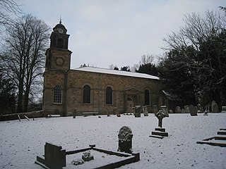
Ossington is a village in the county of Nottinghamshire, England 7 miles north of Newark-on-Trent. It is in the civil parish of Ossington, but for census purposes its population count is included with the civil parishes of Ompton and Laxton and Moorhouse. It was centred on Ossington Hall, the ancestral home of the Denison family, but the house was demolished in 1964 and all that remains are a few outbuildings and a private chapel that now serves the parish as Holy Rood Church, Ossington. This is a Grade I listed building, originally 12th century and rebuilt in 1782–1783 by the architect John Carr, with minor 19th-century alterations and additions. It includes earlier monuments and stained glass. There is a barrel organ built by Thomas Robson in 1840.

Stephen D. Smith MBE is a Holocaust and genocide specialist who has designed, operated and consulted for many different Holocaust memorial centres. He currently holds the UNESCO Chair on Genocide Education.

Kneesall is a village and civil parish in the East Midlands of England in the county of Nottinghamshire. The population of the civil parish at the 2011 census was 221. Forming part of the Newark and Sherwood district, Kneesall is situated on the A616 between Newark-on-Trent and Ollerton. The village is three miles from neighbouring Eakring and four miles from Laxton.

<span class="mw-page-title-main">Trysull</span> Human settlement in England

Trysull is a rural village in the county of Staffordshire, England approximately five miles south-west of Wolverhampton. With the adjacent village of Seisdon, it forms the civil parish of Trysull and Seisdon, within the South Staffordshire non-metropolitan district. Until 1974 it formed part of Seisdon Rural District. The 2011 census recorded a usually resident population for the parish of Trysull & Seisdon of 1,150 persons in 455 households.

<span class="mw-page-title-main">Langwith, Derbyshire</span> Collection of villages in Derbyshire, England

Langwith is a close group of six villages crossing the Derbyshire-Nottinghamshire border, on the River Poulter about 2 miles (3.2 km) from Warsop, and about 4 miles (6.4 km) from Bolsover on the A632 road, south of Whaley Thorns. The population is listed under the Derbyshire civil parish of Langwith and the Nottinghamshire civil parish of Nether Langwith.

<span class="mw-page-title-main">Laxton Castle</span>

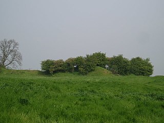
Laxton Castle is a late 11th- or early 12th-century medieval castle located north of the village of Laxton in Nottinghamshire, England. According to an early 20th-century report by the British Archaeological Association, the site is notable not only as "the most striking specimen of a mount and court stronghold" in the area, but also for "the nearly perfect condition of its two courts", which made of it a valuable resource for study.

<span class="mw-page-title-main">Moorhouse, Nottinghamshire</span> Human settlement in England

Moorhouse or Laxton Moorhouse is a hamlet within the Laxton and Moorhouse parish, in the Newark and Sherwood district of central Nottinghamshire, England.

<span class="mw-page-title-main">Laxton and Moorhouse</span> Civil parish in England

Laxton and Moorhouse is a civil parish in the Newark and Sherwood district, within the county of Nottinghamshire, England.

<span class="mw-page-title-main">Moorgreen</span> Settlement in England

Moorgreen is a hamlet in the Broxtowe district of Nottinghamshire, England. It is 115 miles (185 km) north west of London, 7 miles (11 km) north west of the city of Nottingham, and 1+14 miles (2 km) north east of the nearest town Eastwood. It is a linear settlement within the civil parish of Greasley.

References

  1. UK Census (2021). "2021 Census Area Profile – Laxton and Moorhouse (E04007923)". Nomis. Office for National Statistics . Retrieved 12 January 2024.
  2. "Civil parish population 2011". Neighbourhood Statistics. Office for National Statistics. Retrieved 12 April 2016.
  3. Gannett, Henry (1905). The Origin of Certain Place Names in the United States. U.S. Government Printing Office. p.  186.
  4. Beckett, J.V. (1989) A history of Laxton : England's last open-field village, Oxford : Basil Blackwell, ISBN   0-631-15972-X
  5. Orwin, C.S. and Orwin, C.S. (1938) The open fields, Oxford : Clarendon Press, 332 p.
  6. "Laxton Heritage". University of Nottingham. Retrieved 11 February 2023.
  7. "Laxton and Morehouse | British History Online". www.british-history.ac.uk. Retrieved 10 November 2020.
  8. Beth Shalom web site, About Us [ permanent dead link ]