A beacon is an intentionally conspicuous device designed to attract attention to a specific location. A common example is the lighthouse, which draws attention to a fixed point that can be used to navigate around obstacles or into port. More modern examples include a variety of radio beacons that can be read on radio direction finders in all weather, and radar transponders that appear on radar displays.
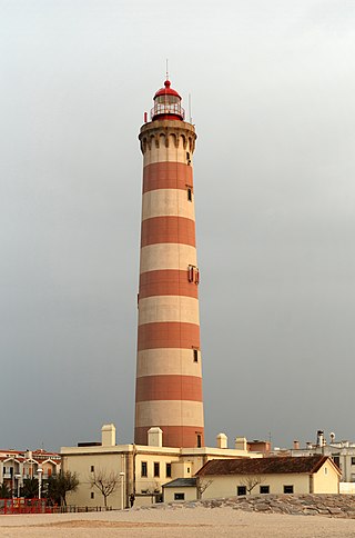
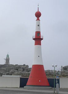
A lighthouse is a tower, building, or other type of physical structure designed to emit light from a system of lamps and lenses and to serve as a beacon for navigational aid, for maritime pilots at sea or on inland waterways.

A lightvessel, or lightship, is a ship that acts as a lighthouse. They are used in waters that are too deep or otherwise unsuitable for lighthouse construction. Although some records exist of fire beacons being placed on ships in Roman times, the first modern lightvessel was off the Nore sandbank at the mouth of the River Thames in London, England, placed there by its inventor Robert Hamblin in 1734. The type has become largely obsolete; lighthouses replaced some stations as the construction techniques for lighthouses advanced, while large, automated buoys replaced others.
Piloting or pilotage is the process of navigating on water or in the air using fixed points of reference on the sea or on land, usually with reference to a nautical chart or aeronautical chart to obtain a fix of the position of the vessel or aircraft with respect to a desired course or location. Horizontal fixes of position from known reference points may be obtained by sight or by radar. Vertical position may be obtained by depth sounder to determine depth of the water body below a vessel or by altimeter to determine an aircraft's altitude, from which its distance above the ground can be deduced. Piloting a vessel is usually practiced close to shore or on inland waterways. Pilotage of an aircraft is practiced under visual meteorological conditions for flight.
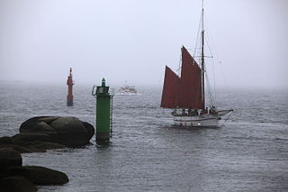
A sea mark, also seamark and navigation mark, is a form of aid to navigation and pilotage that identifies the approximate position of a maritime channel, hazard, or administrative area to allow boats, ships, and seaplanes to navigate safely.
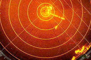
Radar beacon is – according to article 1.103 of the International Telecommunication Union's (ITU) ITU Radio Regulations (RR) – defined as "A transmitter-receiver associated with a fixed navigational mark which, when triggered by a radar, automatically returns a distinctive signal which can appear on the display of the triggering radar, providing range, bearing and identification information." Each station shall be classified by the service in which it operates permanently or temporarily.

A day beacon is an unlighted nautical sea mark. A signboard identifying it is called a day mark. Day beacons typically mark channels whose key points are marked by lighted buoys. They may also mark smaller navigable routes in their entirety. They are the most common navigation aid in shallow water, as they are relatively inexpensive to install and maintain. Navigation around them is similar to that around other navigation aids.

The Gasparilla Island Lights are on Gasparilla Island in Boca Grande, Florida. The Port Boca Grande Lighthouse is on the southern tip of Gasparilla Island, and marked the Boca Grande Pass entrance to Charlotte Harbor.

A navigational aid (NAVAID), also known as aid to navigation (ATON), is any sort of signal, markers or guidance equipment which aids the traveler in navigation, usually nautical or aviation travel. Common types of such aids include lighthouses, buoys, fog signals, and day beacons.

The first Saginaw River lighthouse was constructed from 1839 to 1841, in a period when large quantities of lumber were being harvested and shipped from the heart of Michigan via river and the Great Lakes to the East Coast of the United States via the Erie Canal and Hudson River. This connection to major eastern markets was critical to the development of central Michigan.

United States lightship Nantucket (LV-112) is a National Historic Landmark lightship that served at the Lightship Nantucket position. She was the last serving lightship and at time of its application as a landmark, one of only two capable of moving under their own power. She served as the lightship for such notable vessels as the liners United States, Queen Mary, and Normandie.

Winterton Lighthouse is located in Winterton-on-Sea in the English county of Norfolk. In 1845 Winterton Ness was described as being 'well known to the mariner as the most fatal headland between Scotland and London'. As well as marking the headland, the lighthouse was intended to help guide vessels into the Cockle Gat, which provided the northern entry into the safe water of Yarmouth Roads. The lighthouse was known to Daniel Defoe and is mentioned in his novel Robinson Crusoe.

The Newburyport Harbor Front Range Light is one of two historic range lights in Newburyport, Massachusetts. When it was built in 1873, it was located at Bayley's Wharf, and provided, in combination with the Rear Range Light, a critical aid for navigating into Newburyport's harbor. In 1964 the light was moved to its present location on the grounds of the Merrimack River Coast Guard Station. The stations are no longer in service, but serves as a daymark for arriving mariners.

The Newburyport Harbor Rear Range Light is a historic lighthouse at 61½ Water St. near the Merrimack River in Newburyport, Massachusetts. It was built in 1873 as one of a pair of range lights for guiding ships up the river to the city's harbor.

Hospital Point Range Front Light is a historic lighthouse at the end of Bayview Avenue in Beverly, Massachusetts. It forms the front half of a range which guides vessels toward Salem Harbor. The tower was added to the National Register of Historic Places as Hospital Point Light Station on September 28, 1987.

The Wood Islands Lighthouse is a historic lighthouse built by Donald MacMillan situated on the southeastern shore of Prince Edward Island, located in the community of Wood Islands. The lighthouse is a well-preserved three storey tower with an adjoining 1+1⁄2-storey keeper's residence. The white shingled tower is topped by a red iron lantern, which is enclosed by a white railing on the observation deck. The red roof of the dwelling provides a striking contrast to the white shingled exterior of the dwelling.
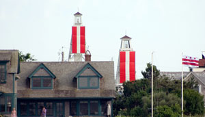
The Nantucket Harbor Range Lights are range lights that were built in 1908 to guide vessels through the narrow channel to Nantucket Harbor. They replaced an older arrangement involving the Nantucket Beacon and the Brant Point Light, which became unusable when the latter was replaced with a new tower.

The Nantucket Beacon formed a range with the Brant Point Light to guide vessels into Nantucket harbor. Operated at various times in the 19th century, it was deactivated sometime after 1870. This range was eventually succeeded by the Nantucket Harbor Range Lights, which are still in operation.
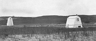
The Nantucket Cliff Lights, also known as the Nantucket Cliff Range Lights were a set of range lights on Nantucket. Over the years, there were several sets of range lights to lead ships into Nantucket Harbor. The first were built in 1838. The second, a pair of conical white towers which still exist-owned by the Gilbreth family of "Cheaper by the Dozen" Fame-although not on the same site, were discontinued in 1912. The Gilbreth Family purchased the two latter range lights in 1921.
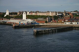
The High and Low Lights of North Shields are decommissioned leading lights in North Shields, Tyne and Wear in the United Kingdom. Two pairs of lights survive: the older pair date from 1727 and were operational until 1810; the newer pair then took over, remaining in use until 1999. All four are listed buildings. They were sometimes known as the Fish Quay High and Low Lights, or as 'Fish Quay ' and 'Dockwray Square '.