Related Research Articles

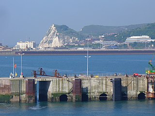
Dover is a town and major ferry port in Kent, South East England. It faces France across the Strait of Dover, the narrowest part of the English Channel at 33 kilometres (21 mi) from Cap Gris Nez in France. It lies south-east of Canterbury and east of Maidstone. The town is the administrative centre of the Dover District and home of the Port of Dover.
Dover is a local government district in Kent, England. It is named after its largest town, the port town of Dover. The council is based in Whitfield on the outskirts of Dover. The district also covers the towns of Deal, Sandwich and Walmer as well as the surrounding rural areas.
The Knott family of lighthouse keepers is credited with the longest period of continuous service in the history of staffed lighthouses, commencing in 1730 at South Foreland, Kent, with William Knott and ending in 1906 at Skerries with Henry Thomas Knott who died in 1910 having retired to Crewe. There are three famous lighthouse-keeping families in England, the other two being the Darling and the Hall families. The three families are inter-related.

Dover Priory railway station is the southern terminus of the South Eastern Main Line in England, and is the main station serving the town of Dover, Kent, the other open station being Kearsney, on the outskirts. It is 77 miles 26 chains (124.4 km) down the line from London Victoria. The station and all trains that serve the station are operated by Southeastern. This station is a 25 min walk away from the Ferry Port.

Martin Mill railway station serves the small village of Martin Mill in East Kent. The station and all trains serving it are operated by Southeastern. The booking office is open only on weekday mornings however a ticket machine on the Dover-bound platform caters for out-of-hours ticketing. For many years the ticket office acted as a Post Office for the local community.
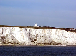
South Foreland is a chalk headland on the Kent coast of southeast England. It presents a bold cliff to the sea, and commands views over the Strait of Dover. It is centred 3 miles (4.8 km) northeast of Dover and 15 miles south of North Foreland. It includes the closest point on the Island of Britain to the European mainland at a distance of 20.6 miles (33.2 km).

Dover is a constituency represented in the House of Commons of the UK Parliament since 2019 by Natalie Elphicke, a Conservative.

The Saxon Shore Way is a long-distance footpath in England. It starts at Gravesend, Kent, and traces the coast of South-East England as it was in Roman times as far as Hastings, East Sussex, 163 miles (262 km) in total. This means that around Romney Marsh the route runs significantly inland from the modern coastline.
Dover District Council is the local authority for the Dover District in Kent, England. The council is elected every four years.
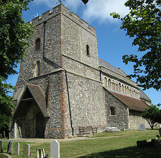
St. Margaret's at Cliffe is a three-part village situated just off the coast road between Deal and Dover in Kent, England. The centre of the village is about ¾ mile (1 km) from the sea, with the residential area of Nelson Park further inland, and St Margaret's Bay situated along and below the cliffs north of South Foreland. The parish church, dedicated to St Margaret of Antioch, is a Grade I listed building.

The A258 road is an A road in England, running through East Kent from Dover to Sandwich.
The Dover Patrol and later known as the Dover Patrol Force was a Royal Navy command of the First World War, notable for its involvement in the Zeebrugge Raid on 22 April 1918. The Dover Patrol formed a discrete unit of the Royal Navy based at Dover and Dunkirk for the duration of the First World War. Its primary task was to prevent enemy German shipping—chiefly submarines—from entering the English Channel en route to the Atlantic Ocean, thereby obliging the Imperial German Navy to travel via the much longer route around Scotland which was itself covered by the Northern Patrol.

West Cliffe or Westcliffe is a village and former civil parish, now in the parish of St. Margaret's At Cliffe, in the Dover district, in east Kent, England, near Dover. In 1931 the parish had a population of 88.
St Margaret's Bay Windmill is a Grade II listed Smock mill on South Foreland, the southeasternmost point of England. It was built in 1929 to generate electricity for the attached house, high on the White Cliffs of Dover.

SS Maloja was an M-class passenger steamship of the Peninsular and Oriental Steam Navigation Company. She was completed in 1911 and worked a regular route between Great Britain and India. In 1916 in the First World War she was sunk by a mine in the English Channel off Dover with the loss of 155 lives.
St Edmund's Catholic School is a co-educational Roman Catholic secondary school located in Dover, Kent, England. The school is named after Edmund of Abingdon, and is under the jurisdiction of the Roman Catholic Archdiocese of Southwark.
These awards were created to celebrate design excellence in Kent and were first staged in 2003 and are usually held every two years. They were then renamed 'Kent Design and Development Awards' in 2012. Then have stayed as the 'Kent Design and Development Awards' in 2014.

Cliffe is a village and former civil parish, now in the parish of Cliffe and Cliffe Woods, in the borough of Medway in the ceremonial county of Kent, England. It is on the Hoo Peninsula, reached from the Medway Towns by a three-mile (4.8 km) journey along the B2000 road. Situated upon a low chalk escarpment overlooking the Thames marshes, Cliffe offers views of Southend-on-Sea and London. In 774 Offa, King of Mercia, built a rustic wooden church dedicated to St Helen, a popular Mercian saint who was by legend the daughter of Coel of Colchester. Cliffe is cited in early records as having been called Clive and Cliffe-at-Hoo. In 1961 the parish had a population of 2239. On 1 April 1997 the parish was abolished to form "Cliffe & Cliiffe Woods", part also went to and Frindsbury Extra.

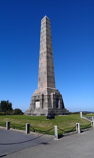
The Dover Patrol Monuments are a trio of war memorials designed by Sir Aston Webb to commemorate the Royal Navy's Dover Patrol of the First World War. Two identical granite memorial obelisks, 75 feet (23 m) high, were erected near Dover and on the Cap Blanc-Nez near Calais in 1921 and 1922. A third was erected in Brooklyn, New York, in 1931. The UK monument became a Grade II listed building in August 1966, promoted to Grade II* in August 2015.
Leathercoat may refer to:
References
- ↑ "The Dover Patrol Monument (War Memorial) and associated railed surround, steps and concrete posts". Archived from the original on 16 September 2023. Retrieved 16 September 2023.
- ↑ "Leathercoat Point, St Margaret's at Cliffe, Kent :: The British Place Names Website". Archived from the original on 16 September 2023. Retrieved 16 September 2023.
51°09′24″N1°23′39″E / 51.1566°N 1.3941°E
| | This United Kingdom location article is a stub. You can help Wikipedia by expanding it. |