Lena (river)

Last updated
Lena
Lone-maiden-formation.jpg
The Lena Pillars along the river near Yakutsk
Lena River basin.png
Lena watershed
Native name
Location
Country Russia
Physical characteristics
Source Baikal Mountains
  location Kachugsky District, Irkutsk Oblast
  coordinates 53°58′3″N107°52′56″E / 53.96750°N 107.88222°E / 53.96750; 107.88222 (approximately)
  elevation1,640 m (5,380 ft)
Mouth Lena Delta
  location
Arctic Ocean, Laptev Sea
  coordinates
72°24′31″N126°41′05″E / 72.4087°N 126.6847°E / 72.4087; 126.6847
  elevation
0 m (0 ft)
Length4,294 km (2,668 mi)
Basin size2,460,742 km2 (950,098 sq mi) to 2,490,000 km2 (960,000 sq mi)
Width 
  maximum10,000 m (33,000 ft)
Depth 
  maximum28 m (92 ft)
Discharge 
  location Kyusyur, Russia (Basin size: 2,440,000 km2 (940,000 sq mi) to 2,418,974 km2 (933,971 sq mi) [1]
  average(Period of data: 1971-2015)17,773 m3/s (627,600 cu ft/s) [1]

(Period of data: 1970-1999)17,067 m3/s (602,700 cu ft/s) [2]

15,500

Contents

 m3/s (550,000 cu ft/s) [3]
  minimum366 m3/s (12,900 cu ft/s)
  maximum241,000 m3/s (8,500,000 cu ft/s)

Lena Delta, Laptev Sea, Russia (Period of data: 1984-2018)577 km3/a (18,300 m3/s) [1]

(Period of data: 1940-2019) 545.7 km3/a (17,290 m3/s) [4]
Discharge 
  location Vilyuy
  average12,100 m3/s (430,000 cu ft/s)

Tabaga, Yakutsk (Basin size: 987,000 km2 (381,000 sq mi)

(Period of data: 1967-2017) 7,453.2 m3/s (263,210 cu ft/s) [5] (max. 51,600 m3/s (1,820,000 cu ft/s)) [5]
Discharge 
  location Olyokminsk
  average4,500 m3/s (160,000 cu ft/s)
Discharge 
  location Vitim
  average1,700 m3/s (60,000 cu ft/s)
Discharge 
  location Kirensk
  average480 m3/s (17,000 cu ft/s)
Basin features
Tributaries 
  left Vilyuy
  right Kirenga, Vitim, Olyokma, Aldan

The Lena [note 1] is a river in the Russian Far East, and is the easternmost of the three great Siberian rivers that flow into the Arctic Ocean (the other two being the Ob and the Yenisey). The Lena is the eleventh-longest river in the world, and the longest river entirely within Russia, with a length of 4,294 km (2,668 mi) and a drainage basin of 2,490,000 km2 (960,000 sq mi). [6] Permafrost underlies most of the catchment, 77% of which is continuous.

Course

Map including the lower course of the Lena Operational Navigation Chart C-6, 3rd edition.jpg
Map including the lower course of the Lena
Map including the upper reaches of the Lena Operational Navigation Chart D-7, 6th edition.jpg
Map including the upper reaches of the Lena

Originating at an elevation of 1,640 meters (5,381 ft) at its source in the Baikal Mountains south of the Central Siberian Plateau, 7 kilometres (4 mi) west of Lake Baikal, the Lena flows northeast across the Lena-Angara Plateau, being joined by the Kirenga, Vitim and Olyokma. From Yakutsk it enters the Central Yakutian Lowland and flows north until joined by its right-hand tributary the Aldan and its most important left-hand tributary, the Vilyuy. After that, it bends westward and northward, flowing between the Kharaulakh Range, part of the Verkhoyansk Range, in the east and the Chekanovsky Ridge in the west. Making its way nearly due north it expands into a large delta and ends in the Laptev Sea, a division of the Arctic Ocean, south-west of the New Siberian Islands. The Lena Delta is 30,000 square kilometres (12,000 sq mi) in area, [7] being traversed by seven main branches, the most important being the Bykovsky channel, farthest east.

Basin

The area of the Lena river basin is calculated at 2,490,000 square kilometres (960,000 sq mi) and the mean annual discharge is 489 cubic kilometers per year. Gold is washed out of the sands of the Vitim and the Olyokma, and mammoth tusks have been dug out of the delta. There are numerous lakes in the floodplain of the river. Lakes Nedzheli and Ulakhan-Kyuel are the largest in the basin of the Lena.

Tributaries

The Kirenga flows north between the upper Lena River and Lake Baikal. The Vitim drains the area northeast of Lake Baikal. The Olyokma flows north. The Amga makes a long curve southeast and parallel to the Lena and flows into the Aldan. The Aldan also curves roughly parallel to the Lena until it turns east and flows into the Lena north of Yakutsk. The Maya, a tributary of the Aldan, drains an area almost to the Sea of Okhotsk. The T-shaped Chona-Vilyuy system drains most of the area to the west.

The main tributaries of the Lena are, from source to mouth:

History

Lena River from a source to Kachug
BSicon uexDOCKS.svg
unnamed lake
Tyrka
BSicon gKHSTaq.svg
BSicon gSTRq.svg
BSicon gSTRq.svg
BSicon uexnSTR.svg
BSicon gSTRq.svg
BSicon gSTR+r.svg
Uhta 2nd
BSicon uexnSTRq.svg
BSicon uexSTR+r.svg
BSicon uexnSTR.svg
BSicon gSTR.svg
Uhta 1st
BSicon uexnSTRq.svg
BSicon uexSTR+r.svg
BSicon uexnSTR.svg
BSicon uexnSTR+l.svg
BSicon uexnSTRq.svg
BSicon gSTR.svg
Pankukcha
Shevukan
BSicon gKHSTaq.svg
BSicon gFABZq+lr.svg
BSicon gSTRq.svg
BSicon uexnSTR.svg
BSicon gSTRq.svg
BSicon uexnSTR.svg
BSicon gSTRr.svg
BSicon gSTR.svg
BSicon uexnSTR+l.svg
BSicon uexnSTR.svg
BSicon uexSTRr.svg
Negnedai
BSicon uexnSTRq.svg
BSicon gSTR.svg
BSicon uexnSTRq.svg
BSicon uexSTR+r.svg
BSicon uexnSTR.svg
BSicon gSTR+l.svg
BSicon gSTRr.svg
BSicon uexnSTR+l.svg
BSicon uexnSTR.svg
BSicon uexnSTRq.svg
Anai River
BSicon gSTR.svg
BSicon uexnSTR.svg
BSicon gSTR+l.svg
BSicon gKHSTeq.svg
Anai
BSicon gSTR.svg
BSicon uexnSTR+l.svg
BSicon uexnSTR.svg
BSicon gSTR.svg
BSicon uexnSTRq.svg
Alilei
BSicon gSTR.svg
BSicon uexnSTR+l.svg
BSicon uexnSTR.svg
BSicon gSTR.svg
BSicon uexnSTRq.svg
Chanchur River
BSicon gSTR.svg
BSicon uexnSTR.svg
BSicon gHST.svg
Chanchur
BSicon gSTRl.svg
BSicon gFABZq+lr.svg
BSicon gSTRq.svg
BSicon uexnSTR.svg
BSicon gSTRr.svg
Kurungui
BSicon gHST.svg
BSicon uexnSTR.svg
BSicon uexnSTR+l.svg
BSicon uexnSTRq.svg
Ilikta
Kurungui River
BSicon uexnSTRq.svg
BSicon gSTR.svg
BSicon uexnSTRq.svg
BSicon uexSTR+r.svg
BSicon uexnSTR.svg
BSicon uexnSTR.svg
BSicon gKBHFe.svg
BSicon RM.svg
Maliy Tarel
Birulka
BSicon gKBHFe.svg
BSicon RM+l.svg
BSicon RMq.svg
BSicon uxmKRZu.svg
BSicon RMq.svg
BSicon uexnSTR.svg
BSicon RM.svg
BSicon RMr.svg
Ice bridge
BSicon RM.svg
BSicon uexABZg+l.svg
BSicon uexSTRr.svg
BSicon RM.svg
Birulka River
BSicon uexnSTRq.svg
BSicon RM.svg
BSicon uexnSTRq.svg
BSicon uexABZg+r.svg
BSicon RM+l.svg
BSicon RMr.svg
Ushina
BSicon RMCONTgq.svg
BSicon gKBHFa.svg
BSicon RMr.svg
BSicon uexnSTR+l.svg
BSicon uexSTR.svg
BSicon uexnSTRq.svg
BSicon RM.svg
BSicon uexnSTRq.svg
Zhuya
BSicon gSTR.svg
BSicon uexSTR.svg
BSicon gKHSTaq.svg
BSicon RM.svg
Bolshoi Kosogol
BSicon gSTR.svg
BSicon uexnSTR+l.svg
BSicon uexSTR.svg
BSicon uexnSTRq.svg
BSicon RM.svg
BSicon uexnSTRq.svg
Manzurka
Khalsk
BSicon gSTR.svg
BSicon uexSTR.svg
BSicon RMl.svg
BSicon gKBHFe.svg
BSicon RMCONTfq.svg
Bolshiye Goly
BSicon gFABZgl+l.svg
BSicon gBHF.svg
BSicon BOOT2.svg
BSicon uexSTR.svg
BSicon RM+l.svg
BSicon gKHSTeq.svg
BSicon RMCONTfq.svg
Iset

It is commonly believed that the Lena derives its name from the original Even-Evenk name Elyu-Ene, which means "the Large River".

The river around 1890 Parokhod na Lene.jpg
The river around 1890

According to folktales related a century later, in the years 1620–1623 a party of Russian fur hunters under the leadership of Demid Pyanda sailed up Nizhnyaya Tunguska, discovered the Lena, and either carried their boats there or built new ones. In 1623 Pyanda explored some 2,400 kilometres (1,500 mi) of the river from its upper reaches to the central Yakutia. [8] In 1628 Vasily Bugor and 10 men reached the Lena, collected 'yasak' (tribute) from the 'natives' and then founded Kirinsk in 1632. In 1631 the voyevoda of Yeniseysk sent Pyotr Beketov and 20 men to construct a fortress at Yakutsk (founded in 1632). From Yakutsk other expeditions spread out to the south and east. The Lena delta was reached in 1633.

Two of the three groups of survivors of the ill-fated Jeannette expedition reached Lena Delta in September, 1881. The one led by engineer George W. Melville was rescued by native Tungus huntsmen. Of the group led by Captain George W. De Long, only two of the men survived; the others died of starvation.

Baron Eduard Von Toll, accompanied by Alexander von Bunge, led an expedition that explored the Lena delta and the islands of New Siberia on behalf of the Russian Imperial Academy of Sciences in 1885. In 1886 they investigated the New Siberian Islands and the Yana River and its tributaries. During one year and two days the expedition covered 25,000 kilometres (16,000 mi), of which 4,200 kilometres (2,600 mi) were up rivers, carrying out geodesic surveys en route.

The Lena massacre was the name given to the 1912 shooting-down of striking goldminers and local citizens who protested at the working conditions in the mine near Bodaybo in northern Irkutsk. The incident was reported in the Duma (parliament) by Kerensky and is credited with stimulating revolutionary feeling in Russia.

Vladimir Ilyich Ulyanov may have taken his alias, Lenin, from the river Lena, when he was exiled to the Central Siberian Plateau.

Delta

Lena River Delta in Autumn 2014 Lena River Delta IMG 20140908 201936.jpg
Lena River Delta in Autumn 2014
Lena river Delta by Landsat, February 2000 Lena River Delta - Landsat 2000.jpg
Lena river Delta by Landsat, February 2000

At the end of the Lena River there is a large delta that extends 100 kilometres (62 mi) into the Laptev Sea and is about 400 km (250 mi) wide. The delta is frozen tundra for about seven months of the year, but in May the region is transformed into a lush wetland for a few months. Part of the area is protected as the Lena Delta Wildlife Reserve.

The Lena delta divides into a multitude of flat islands. The most important are (from west to east): Chychas Aryta, Petrushka, Sagastyr, Samakh Ary Diyete, Turkan Bel'keydere, Sasyllakh Ary, Kolkhoztakh Bel'keydere, Grigoriy Diyelyakh Bel'kee (Grigoriy Islands), Nerpa Uolun Aryta, Misha Bel'keydere, Atakhtay Bel'kedere, Arangastakh, Urdiuk Pastakh Bel'key, Agys Past' Aryta, Dallalakh Island, Otto Ary, Ullakhan Ary and Orto Ues Aryta.

Turukannakh-Kumaga is a long and narrow island off the Lena delta's western shore.

One of the Lena delta islands, Ostrov Amerika-Kuba-Aryta or Ostrov Kuba-Aryta, was named after the island of Cuba during Soviet times. It is on the northern edge of the delta. [9]

Fish

As Lena is located at remote and undeveloped regions of the Russian Far East, its fish resrouce is very well perserved. Some of the species found in the river include: Siberian taimen, Siberian sturgeon, Upper Yenisei grayling. [10] [11]


Further reading

See also

Notes

  1. Russian: Ле́на, IPA: [ˈlʲɛnə] ; Evenki: Елюенэ, Eljujene; Yakut: Өлүөнэ, Ölüöne; Buryat: Зүлхэ, Zülkhe; Mongolian: Зүлгэ, Zülge

Related Research Articles

<span class="mw-page-title-main">Sakha Republic</span> First-level administrative division of Russia

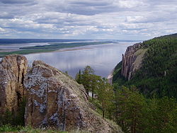
Sakha, officially the Republic of Sakha (Yakutia), is the largest republic of Russia, located in the Russian Far East, along the Arctic Ocean, with a population of one million. Sakha comprises half of the area of its governing Far Eastern Federal District, and is the world's largest country subdivision, covering over 3,083,523 square kilometers (1,190,555 sq mi). Yakutsk, which is the world's coldest major city, is its capital and largest city.

<span class="mw-page-title-main">Laptev Sea</span> Marginal sea in the Arctic Ocean north of Siberia between the Kara Sea and the East Siberian Sea

The Laptev Sea is a marginal sea of the Arctic Ocean. It is located between the northern coast of Siberia, the Taimyr Peninsula, Severnaya Zemlya and the New Siberian Islands. Its northern boundary passes from the Arctic Cape to a point with co-ordinates of 79°N and 139°E, and ends at the Anisiy Cape. The Kara Sea lies to the west, the East Siberian Sea to the east.

<span class="mw-page-title-main">Yerofey Khabarov</span> 17th-century Russian explorer

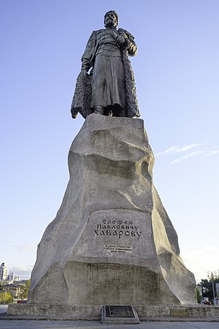
Yerofey Pavlovich Khabarov-Svyatitsky, was a Russian entrepreneur and adventurer, best known for his exploring the Amur river region and his attempts to colonize the area for Russia. For background, see Russian–Manchu border conflicts.

<span class="mw-page-title-main">Yana (river)</span> River in Sakha, Russia

The Yana is a river in Sakha in Russia, located between the Lena to the west and the Indigirka to the east.

<span class="mw-page-title-main">Vilyuy</span> River in Yakutia, Russia

The Vilyuy is a river in Russia, the longest tributary of the Lena. About 2,650 kilometres (1,650 mi) long, it flows mostly within the Sakha Republic. Its basin covers about 454,000 square kilometres (175,000 sq mi).

<span class="mw-page-title-main">Olyokma</span> River in Yakutia, Russia

The Olyokma is a tributary of the Lena in eastern Siberia.

<span class="mw-page-title-main">Vitim (river)</span> River in Russia

The Vitim is a major tributary of the Lena. Its source is east of Lake Baikal, at the confluence of rivers Vitimkan from the west and China from the east. The Vitim flows first south, bends eastwards and then northward in the Vitim Plateau. Then it flows north through the Stanovoy Highlands and the town of Bodaybo. Including river Vitimkan, its western source, it is 1,978 kilometres (1,229 mi) long, and has a drainage basin of 225,000 square kilometres (87,000 sq mi).

<span class="mw-page-title-main">Olenyok (river)</span> River in Yakutia, Russia

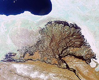
The Olenyok is a major river in northern Siberian Russia, west of the lower Lena and east of the Anabar. It is 2,292 kilometres (1,424 mi) long, of which around 1,000 kilometres (620 mi) is navigable. Average water discharge is 1,210 cubic metres per second (43,000 cu ft/s).

<span class="mw-page-title-main">Siberian River Routes</span> Main ways of communication in the Russian Siberia before the 1730s

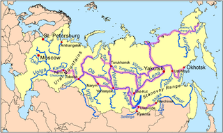
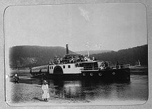
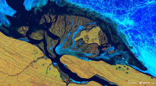
Siberian River Routes were the main ways of communication in Russian Siberia before the 1730s, when roads began to be built. The rivers were also of primary importance in the process of Russian conquest and exploration of vast Siberian territories eastwards. Since the three great Siberian rivers, the Ob, the Yenisey, and the Lena all flow into the Arctic Ocean, the aim was to find parts or branches of these rivers that flow approximately east-west and find short portages between them. Since Siberia is relatively flat, portages were usually short. Despite resistance from the Siberian tribes, Russian Cossacks were able to expand from the Urals to the Pacific in only 57 years (1582-1639). These river routes were crucial in the first years of the Siberian fur trade as the furs were easier to transport over water than land. The rivers connected the major fur gathering centers and provided for relatively quick transport between them.

Demid Sofonovich Pyanda or, according to some sources, Panteley Demidovich Pyanda, also spelled Penda (Пенда) was among the first and most important Russian explorers of Siberia. According to few historical documents and later reconstructions based on them, Pyanda, in 1620–1623, while leading a party which was hunting for Siberian furs and buying them from the locals, became the first known Russian to ascend the Lower Tunguska River and reach the proximity of the Lena, one of the world's greatest rivers. According to later legendary accounts, collected a century after his journey, Pyanda allegedly discovered the Lena River, explored much of its length, and via the Angara River returned to the Yenisey, whence he came.

<span class="mw-page-title-main">Kodar Mountains</span> Mountain range in Siberia

The Kodar Mountains are a mountain range in the Transbaikal region of Siberia, Russia. The name Kodar is derived from "khada", an Evenki word for rock.

<span class="mw-page-title-main">Central Yakutian Lowland</span> Low alluvial plain in Siberia, Russia

The Central Yakutian Lowland or Central Yakutian Lowlands, also known as Central Yakut Plain or Vilyuy Lowland, is a low alluvial plain in Siberia, Russia.

<span class="mw-page-title-main">South Siberian Mountains</span> Series of mountain ranges in Russia and Mongolia

The South Siberian Mountains are one of the largest mountain systems of the Russian Federation. The total area of the system of mountain ranges is more than 1.5 million km². The South Siberian Mountains are located in the Siberian and Far Eastern Federal Districts of Russia, as well as partly in Mongolia. The territory of the mountain system is one of the Great Russian Regions.

<span class="mw-page-title-main">Patom Highlands</span>

The Patom Highlands are a mountainous area in Eastern Siberia, Russia. Administratively most of the territory of the uplands is part of Irkutsk Oblast, with a smaller section in northern Zabaykalsky Krai.

<span class="mw-page-title-main">Kalar Range</span>

The Kalar Range is a mountain range in Zabaykalsky Krai and the NW end of Amur Oblast, Russian Federation. The highest point of the range is 2,520 m (8,270 ft) high Skalisty Golets.

<span class="mw-page-title-main">North Baikal Highlands</span> Mountainous area in Russia

The North Baikal Highlands are a mountainous area in Eastern Siberia, Russia. Administratively the territory of the uplands is part of Buryatia and Irkutsk Oblast.

<span class="mw-page-title-main">Chekanovsky Ridge</span> Mountain range in Yakutia, Russia

The Chekanovsky Ridge is a range of mountains in the Bulunsky District, Yakutia, Russian Federation. The area of the range is uninhabited.

<span class="mw-page-title-main">Akitkan Range</span> Mountain range in Buryatia

The Akitkan Range is a mountain range in Irkutsk Oblast and Buryatia, Russian Federation.

<span class="mw-page-title-main">Kelimyar</span> River in Yakutia (Sakha Republic), Russia

The Kelimyar is a river in Yakutia, Russia. It is a tributary of the Olenyok with a length of 254 kilometres (158 mi) and a drainage basin area of 4,050 square kilometres (1,560 sq mi).

<span class="mw-page-title-main">Chirkuo</span> River in Yakutia, Russia

The Chirkuo is a river in Yakutia, Russia. It is a right hand tributary of the Vilyuy, and is 118 kilometres (73 mi) long —206 kilometres (128 mi) including the Duikhta at its head, with a drainage basin of 7,710 square kilometres (2,980 sq mi).

References

  1. 1 2 3 Stadnyk, Tricia A.; Tefs, A.; Broesky, M.; Déry, S. J.; Myers, P. G.; Ridenour, N. A.; Koenig, K.; Vonderbank, L.; Gustafsson, D. (2021). "Changing freshwater contributions to the Arctic". Elementa: Science of the Anthropocene. 9 (1): 00098. Bibcode:2021EleSA...9...98S. doi: 10.1525/elementa.2020.00098 . S2CID   236682638.
  2. "Variations of the Present-Day Annual and Seasonal Runoff in the Far East and Siberia with the Use of Regional Hydrological and Global Climate Models" (PDF). 2018.
  3. http://www.abratsev.narod.ru/biblio/sokolov/p1ch23b.html, Sokolov, Eastern Siberia // Hydrography of USSR. (in russian)
  4. "River Discharge".
  5. 1 2 Gautier, Emmanuèle; Dépret, Thomas; Cavero, Julien; Costard, François; Virmoux, Clément; Fedorov, Alexander; Konstantinov, Pavel; Jammet, Maël; Brunstein, Daniel (2021). "HAL". Science of the Total Environment. 783: 147020. doi: 10.1016/j.scitotenv.2021.147020 . PMID   34088165. S2CID   234836524.
  6. "Река Ленаin the State Water Register of Russia". textual.ru (in Russian).
  7. "Lena River Delta - A Global Ecoregion". World Wide Fund for Nature. 2006-07-06. Archived from the original on 2007-06-30. Retrieved 2008-05-23.
  8. "Открытие русскими Средней и Восточной Сибири". www.randewy.ru. Retrieved 4 April 2018.
  9. "Google Maps". Google Maps. Retrieved 4 April 2018.
  10. Rose-Innes, Keith (12 May 2020). "The Taimen of Russia's Tugur River". Fly Fisherman. Retrieved 22 March 2024.
  11. Kirillov, A. F.; Knizhin, I. B. (August 2014). "Ichthyofauna of the Lena River (Laptev Sea Basin): Modern composition and historical formation". Journal of Ichthyology. 54 (7): 433–445. doi:10.1134/S0032945214040031 . Retrieved 22 March 2024.