The history of Guernsey stretches back with evidence of Neolithic occupation, followed by Roman occupation. Christianity was brought to Guernsey by St Sampson.

Alderney is the northernmost of the inhabited Channel Islands. It is part of the Bailiwick of Guernsey, a British Crown dependency. It is 3 miles (5 km) long and 1+1⁄2 miles (2.4 km) wide.

Fort Grey, colloquially known as the "cup and saucer", is a Martello tower located on a tidal rock in Rocquaine Bay in Saint Peter, Guernsey on the west coast of the island.

Saint Peter Port Harbour is located in Saint Peter Port, Guernsey. It was a natural anchorage used by the Romans which has been changed into an artificial harbour that is now the island's main port for passengers. Loose cargo, liquids and gas are shipped to and from St Sampson's harbour.

Toilers of the Sea is a novel by Victor Hugo published in 1866. The book is dedicated to the island of Guernsey, where Hugo spent 15 years in exile. Hugo uses the setting of a small island community to transmute seemingly mundane events into drama of the highest calibre. Les Travailleurs de la Mer is set just after the Napoleonic Wars and deals with the impact of the Industrial Revolution upon the island.

HMS Victory was a 100-gun first-rate ship of the line of the Royal Navy, built to the dimensions of the 1733 proposals of the 1719 Establishment at Portsmouth Dockyard, and launched on 23 February 1737.

Les Casquets or (The) Casquets is a group of rocks eight miles (13 km) northwest of Alderney in the Channel Islands; they are administered by the Bailiwick of Guernsey. The rocks are part of an underwater sandstone ridge. Other parts which emerge above the water are the islets of Burhou and Ortac. Little vegetation grows on them.

Castle Cornet is a large island castle in Guernsey, and former tidal island, also known as Cornet Rock or Castle Rock. Its importance was as a defence not only of the island, but of the roadstead. In 1859 it became part of one of the breakwaters of the Guernsey's main harbour, St Peter Port's harbour.
La Corbière is the extreme south-western point of Jersey in St. Brélade. The name means "a place where crows gather", deriving from the word corbîn meaning crow. However, seagulls have long since displaced the crows from their coastal nesting sites.

Godrevy Lighthouse was built in 1858–1859 on Godrevy Island in St Ives Bay, Cornwall. Standing approximately 300 metres (980 ft) off Godrevy Head, it marks the Stones reef, which has been a hazard to shipping for centuries.

Stella was a passenger ferry in service with the London and South Western Railway (LSWR). She was built in Glasgow in 1890, and wrecked in 1899 off the Casquets during a crossing from Southampton to Guernsey.

Bombay Reef is an atoll of the Paracel Islands. In Chinese, the reef is alternatively known as "Pengbojiao", or "Qilianyu" along with six other islands close by.

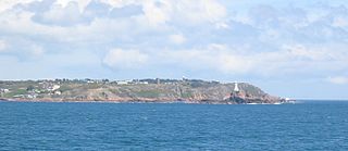
Jerbourg Point or the Jerbourg Peninsula is the southeastern point of the Bailiwick of Guernsey in the English Channel off the coast of Normandy, lying within St Martin Parish. It marks the end of the east coast cliffs and beginning of the south coast cliffs. It provides scenic views of the Little Russel and the various islands.

HMS Boreas was a Laurel-class 22-gun post ship launched in 1806. She was wrecked off Guernsey in the Channel Islands on 28 November 1807 with the loss of most of her crew of 154 men.
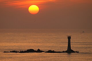
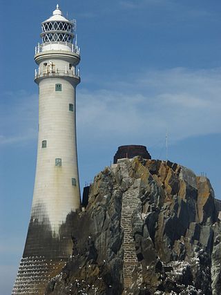
Les Hanois Lighthouse was constructed between 1860 and 1862 to a design by James Walker, and was first lit on 8 December 1862. It is sited on the rock known as Le Biseau, or Le Bisé, part of the reef Les Hanois one mile north west of Pleinmont where the Trinity House cottages were built. It was erected in response to an increasing number of shipwrecks on the treacherous rocks off the western coast of Guernsey.

The SS Nile was an iron-hulled cargo steamship. She is best remembered for her sinking in bad weather on 30 November 1854 with the loss of all hands, most likely after colliding with The Stones, a notoriously dangerous reef off Godrevy Head in Cornwall.
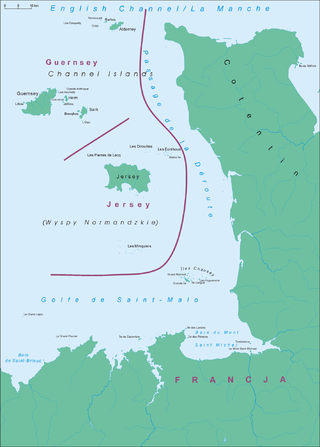
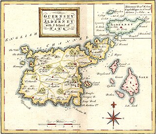
The Channel Islands are a group of islands off the coast of France. The largest island is Jersey, followed by Guernsey, Alderney, Sark, and a number of smaller islands, islets and rocky outcrops. The islands were separated from mainland Europe with rising sea levels in the Neolithic period; thereafter maritime activity commenced.
William Douglass was for twenty-six years an engineer for Trinity House and engineer-in-chief to the Commissioners of Irish Lights from 1878 to 1900. He built a number of offshore lighthouses and was responsible for the design of the second Fastnet Rock lighthouse.

Margaret Brock Reef is a reef in the Australian state of South Australia located in the state's coastal waters on its south-east coast about 7 kilometres (4.3 mi) west of the headland of Cape Jaffa and about 27.2 kilometres (16.9 mi) south-west of the town of Kingston SE. It is the site of both a navigation aid which operated as a staffed lighthouse from 1872 to 1973 and as an automatic beacon onward to the present day, and a rock lobster sanctuary declared under state law in 1973. It is named after the barque Margaret Brock which was wrecked there in 1852.