
Saint Helena is an island in the South Atlantic Ocean, about midway between South America and Africa. St Helena has a land area of 122 square kilometres and is part of the territory of Saint Helena, Ascension and Tristan da Cunha which includes Ascension Island and the island group of Tristan da Cunha.
This article is about the demographics of Saint Helena, Ascension and Tristan da Cunha, a British overseas territory in the south Atlantic Ocean.
The economy of Saint Helena is based on export income from coffee, tourism, fishing, and sales of alcoholic liqueurs. Unemployment is very low in Saint Helena; the February 2016 Census stated that 76 people declared that they were unemployed compared to an economically active population of 2,539 and a total population of 4,534. Saint Helena is one of two countries which depend on financial assistance from the United Kingdom, which amounted to about £22.5 million in 2016/17. This supplements the £12.6 million raised from local tax revenues.
Tristan da Cunha, colloquially Tristan, is both a remote group of volcanic islands in the south Atlantic Ocean and the main island of that group. It is the most remote inhabited archipelago in the world, lying approximately 1,511 miles (2,432 km) off the coast of Cape Town in South Africa, 1,343 miles (2,161 km) from Saint Helena and 2,166 miles (3,486 km) off the coast from the Falkland Islands. The territory consists of the main island, Tristan da Cunha, which has a diameter of roughly 11 kilometres (6.8 mi) and an area of 98 square kilometres (38 sq mi), the smaller, uninhabited Nightingale Islands, and the wildlife reserves of Inaccessible Island and Gough Island. As of October 2018, the main island has 250 permanent inhabitants who all carry British Overseas Territories citizenship. The other islands are uninhabited, except for the personnel of a weather station on Gough Island.

Helena is the eastern portion of Helena-West Helena, Arkansas, a city in Phillips County, Arkansas. As of the 2000 census, this portion of the city population was 6,323. Helena was the county seat of Phillips County until January 1, 2006, when it merged its government and city limits with neighboring West Helena.

St. Helena is a city in Napa County, in California's Wine Country, part of the North Bay region of the San Francisco Bay Area. The population was 5,814 at the 2010 census.
Jamestown is the capital of the British Overseas Territory of Saint Helena, Ascension and Tristan da Cunha, located on the island of Saint Helena in the South Atlantic Ocean. It is also the historic main settlement of the island and is on its north-western coast. It is the island's only port and the centre of the island's road and communications network. It was founded when colonists from the English East India Company settled on the island in 1659 and was briefly occupied by the Dutch East India Company in 1673 before being recaptured. Many of the buildings built by the East India Company in the 1700s survive and give the town its distinctive Georgian flavour.

Longwood is a settlement and a district of the British island of Saint Helena in the South Atlantic.

Half Tree Hollow is the smallest of the eight districts of the island of Saint Helena, part of the British Overseas Territory of Saint Helena, Ascension and Tristan da Cunha in the South Atlantic Ocean. It is a suburb of Jamestown and is situated at the top of Ladder Hill which forms the southern side of the James Valley, at the base of which sits Jamestown. The hill was fortified in the late 1700s and Ladder Hill Fort was subsequently built. The village grew during the 1960s because the James Valley lacked any room for expansion.

Longwood House is a mansion in St. Helena and the final residence of Napoleon Bonaparte, during his exile on the island of Saint Helena, from 10 December 1815 until his death on 5 May 1821. It lies on a windswept plain some 6 km (3.7 mi) from Jamestown.
Blue Hill is one of eight districts of the island of Saint Helena, part of the British Overseas Territory of Saint Helena, Ascension and Tristan da Cunha in the South Atlantic Ocean. It is sparsely populated and comprises the western third of the island. The district is entirely agricultural with no industrial activity.

Prosperous Bay Plain is an area on the eastern coast of Saint Helena, a British island territory in the South Atlantic Ocean. It is the site of the new Saint Helena Airport, and is notable for its high invertebrate biodiversity.
Alarm Forest is the newest of the eight districts of the island of Saint Helena, part of the British Overseas Territory of Saint Helena, Ascension and Tristan da Cunha in the South Atlantic Ocean. It is located southeast of Jamestown, in the interior of the island, and is the only district to lack a coastline.
St. Paul's is one of eight districts of the island of Saint Helena, part of the British Overseas Territory of Saint Helena, Ascension and Tristan da Cunha in the South Atlantic Ocean. It is the second-most heavily populated district on the island and is located on its northwestern coast.
Sandy Bay is one of eight districts of the island of Saint Helena, part of the British Overseas Territory of Saint Helena, Ascension and Tristan da Cunha in the South Atlantic Ocean. Located on the island's southeastern coast, it is sparsely populated and is a popular recreation site.
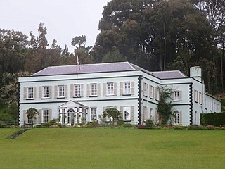
Plantation House is the official residence of the Governor of Saint Helena. It is located 3.6 km (2.2 mi) to the south of the capital, Jamestown, on the island of Saint Helena.

The Castle is the main government building of the British Overseas Territory of Saint Helena, Ascension and Tristan da Cunha, located in Jamestown on the island of Saint Helena. A Grade I-listed building, the oldest parts of the complex date to 1708, but it was largely reconstructed in the 1860s because of termite damage. It does not have the appearance of a typical castle, though historically the site was part of the East India Company fortifications of Jamestown.

German submarine U-975 was a Type VIIC U-boat of Nazi Germany's Kriegsmarine during World War II.


