Lilienthal, Lower Saxony

Last updated
Lilienthal
Wappen Lilienthal.png
Location of Lilienthal within Osterholz district
Lilienthal in OHZ.svgLilienthal
Germany adm location map.svg
Red pog.svg
Lilienthal
Lower Saxony location map.svg
Red pog.svg
Lilienthal
Coordinates: 53°8′N08°55′E / 53.133°N 8.917°E / 53.133; 8.917
Country Germany
State Lower Saxony
District Osterholz
Government
   Mayor (202227) Kim Fürwentsches [1] (Greens)
Area
  Total72.03 km2 (27.81 sq mi)
Highest elevation
12 m (39 ft)
Lowest elevation
0 m (0 ft)
Population
 (2021-12-31) [2]
  Total19,922
  Density280/km2 (720/sq mi)
Time zone UTC+01:00 (CET)
  Summer (DST) UTC+02:00 (CEST)
Postal codes
28865
Dialling codes 04298
Vehicle registration OHZ
Website www.lilienthal.de

Lilienthal is a municipality in the administrative district of Osterholz, Lower Saxony, Germany. It borders Bremen (Free Hanseatic City of Bremen).

Contents

History

Lilienthal belonged to the Prince-Archbishopric of Bremen.

Lilienthal monastery

The history of the small town (without Town privileges) of Lilienthal goes back to its founding as a nunnery by the prince-archbishop Gerhard II. In 1232 construction was begun on a convent of the Order of the Cistercians under the name of Vallis Liliorum (St. Mary's Nunnery in the Valley of Lilies  [ de ]), and the finished building was sanctified in 1264. During the 15th century, the cloister enjoyed a time of prosperity. After the Reformation and the conversion of the Cistercian nuns, it became a Lutheran Women's Convent, and until the end of the Thirty Years' War in 1648 it remained in deplorable conditions. In 1650, the city went through secularization. The land once belonging to the convent, which had become fragmented, developed into the small town of Lilienthal.

Sweden and Hanover

In 1648, according to the terms of the peace treaty that ended the Thirty Years' War (The Peace of Westphalia), the Prince-Archbishopric was transformed into the Duchy of Bremen, ruled together with the Principality of Verden, which were first ruled in personal union by the Swedish Crown. Queen Christina sent one of her commanders over, Graf Friedrich von Hessen-Eschwege, to the newly created barony (Herrschaft) of Osterholz, in which the charge of both Lilienthal and Osterholz were combined. After his early death in 1655, his wife Eleonora took over the government of the barony, with her seat in Osterholz, where she took an active role in the improvement of economic and sanitary conditions for the rural population. After her death in 1692, the barony fell back into the hands of the Swedish Royalty. Lilienthal remained a part of Swedish Bremen-Verden until 1712 (which is why the coat of arms contains the blue and yellow of the Swedish Flag), at which time it came under Danish occupation, and then in 1719 it fell under the sovereignty of the Electorate of Hanover, which ruled Bremen-Verden in personal union.

In 1740, the buildings of the convent except of the church were dismantled.

Astronomy in Lilienthal

In 1782, Johann Hieronymus Schröter became chief magistrate (or bailiff, Amtmann ). In addition to this administrative office, he also played a large part in the advancement of astronomy during his lifetime. On the grounds of his office in Lilienthal, he constructed an observatory. In the following years, the Lilienthal Observatory would become the best equipped observatory in the world. One of its technological advances was the "Riesenteleskop" (giant telescope), a telescope with a 50.8 cm (20 inch) aperture and an 8.25 m focal length. Due to the telescope, Lilienthal became well-known and was sought out in matters of astronomy by government and military officials. Schröter remained in contact with many of the important astronomers of the time. Together with Wilhelm Olbers and other scholars, he founded the "celestial police" in Lilienthal in 1800. The asteroid 3 Juno was discovered September 1, 1804, by Karl Ludwig Harding at the observatory. After Schröter's death in 1816, the observatory fell into disrepair. In 1850 the remaining structure was destroyed. A large part of the observatory was sent to the University of Göttingen before the demolition.

19th century

The Befreiungskrieg (a series of battles fought between 1813 and 1815 that ended the Napoleonic Wars) hit Lilienthal hard. After an incident during a retreat, French troops set the entire village on fire. Only the church, a few houses, and the observatory escaped the flames (but the observatory was looted, and important records were destroyed). [3]

After the reconstruction, the then-municipality grew steadily. In 1939 there were 3,100 inhabitants, in 1974 12,500. After the incorporation of a neighbouring town in the same year, the population grew to 17,000.

In 1823 Bremen-Verden was united in a real union with the Kingdom of Hanover and its territory became part of the Stade Region. In 1866, the kingdom of Hannover lost its independence. Lilienthal became Prussian, in 1885 the bailiwick of Lilienthal was dissolved and combined with that in Osterholz to form the new district of Osterholz.

20th and 21st century

From 1900 to 1956, Lilienthal was connected to Bremen and to the moorland region north of the town by a narrow-gauge railway. Nowadays, its alignment is used as a bikeway.

Since 1 August 2014, public transport in Lilienthal has been upgraded by a line of Bremen Tramway, passing through its main street.

Today, in Lilienthal there are 6 wind turbines, producing 6.013.246,00 kWh, annually.

Schools

Localities

Today, many former independent villages have been merged into Lilienthal.

Some of them had been founded as late as in the moorland cultivation of the 18th century, organized by Jürgen Christian Findorff: Lüningsee (1763), Lüninghausen (1764), Westerwede (1764), Moorende (1778), Mooringen (1778), Schrötersdorf (1805, named after J. H. Schröter) and Neu Mooringen (1808).

There were several dates of merging:

Twinned cities

Related Research Articles

Osterholz is a district (Landkreis) in Lower Saxony, Germany. It is bounded by the districts of Wesermarsch, Cuxhaven, Rotenburg and Verden, and by the city of Bremen.

<span class="mw-page-title-main">Prince-Archbishopric of Bremen</span> Ecclesiastical principality of the Holy Roman Empire

The Prince-Archbishopric of Bremen — not to be confused with the modern Archdiocese of Hamburg, founded in 1994 — was an ecclesiastical principality (787–1566/1648) of the Holy Roman Empire and the Catholic Church that after its definitive secularization in 1648 became the hereditary Duchy of Bremen. The prince-archbishopric, which was under the secular rule of the archbishop, consisted of about a third of the diocesan territory. The city of Bremen was de facto and de jure not part of the prince-archbishopric. Most of the prince-archbishopric lay rather in the area to the north of the city of Bremen, between the Weser and Elbe rivers. Even more confusingly, parts of the prince-archbishopric belonged in religious respect to the neighbouring Diocese of Verden, making up 10% of its diocesan territory.

<span class="mw-page-title-main">Bremen-Verden</span> Territories and immediate fiefs of the Holy Roman Empire

Bremen-Verden, formally the Duchies of Bremen and Verden, were two territories and immediate fiefs of the Holy Roman Empire, which emerged and gained imperial immediacy in 1180. By their original constitution they were prince-bishoprics of the Archdiocese of Bremen and Bishopric of Verden.

<span class="mw-page-title-main">Osterholz-Scharmbeck</span> Town in Lower Saxony, Germany

Osterholz-Scharmbeck is a town and the capital of the district of Osterholz, in Lower Saxony, Germany. Osterholz-Scharmbeck is situated in between the cities of Bremen and Bremerhaven.

<span class="mw-page-title-main">Bouches-du-Weser</span>

Bouches-du-Weser was a department of the First French Empire in present-day Germany. It was formed in 1811, when the region was annexed by France. Prior to the Napoleonic occupation, its territory had been divided between the Free Hanseatic City of Bremen, the duchy of Oldenburg, and the Hanoverian duchies of Bremen and Verden, the latter of which had intermittently been incorporated into the Kingdom of Westphalia in 1807. Its territory is part of the current German states of Lower Saxony and Bremen. Its capital was Bremen.

<span class="mw-page-title-main">Himmelpforten</span> Municipality in Lower Saxony, Germany

Himmelpforten is a municipality west of Hamburg (Germany) in the district of Stade in Lower Saxony. It is located on the Horsterbeck creek. Himmelpforten is also part and the seat of the Samtgemeinde Oldendorf-Himmelpforten.

<span class="mw-page-title-main">Zeven</span> Town in Lower Saxony, Germany

Zeven [] is a town in the district of Rotenburg, in Lower Saxony, Germany. It has a population of around 14,000. The nearest large towns are Bremerhaven, Bremen and Hamburg. It is situated approximately 22 km northwest of Rotenburg, and 40 km northeast of Bremen. Zeven is also the seat of the Samtgemeinde Zeven.

<span class="mw-page-title-main">Land Wursten</span> Samtgemeinde in Lower Saxony, Germany

Land Wursten is a former Samtgemeinde in the district of Cuxhaven, in Lower Saxony, Germany. It was situated approximately 20 km (12 mi) southwest of Cuxhaven, and 15 km (9.3 mi) north of Bremerhaven. Its seat was in the village Dorum. It was disbanded in January 2015, when its member municipalities merged into the new municipality Wurster Nordseeküste.

<span class="mw-page-title-main">Grasberg</span> Municipality in Lower Saxony, Germany

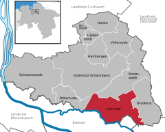
Grasberg is a municipality in the district of Osterholz, in Lower Saxony, Germany. It is situated approximately 13 km southeast of Osterholz-Scharmbeck, and 20 km northeast of Bremen.

<span class="mw-page-title-main">Achim</span> Town in Lower Saxony, Germany

Achim, commonly Achim bei Bremen, is a municipality and the largest town in the district of Verden, in Lower Saxony, Germany. It is situated on the right bank of the Weser, approx. 17 km northwest of Verden, and 16 km southeast of Bremen.

<span class="mw-page-title-main">Oyten</span> Municipality in Lower Saxony, Germany

Oyten is a municipality in the district of Verden, in Lower Saxony, Germany. It is situated approximately 20 km northwest of Verden, and 15 km east of Bremen.

<span class="mw-page-title-main">Flögeln</span> Ortsteil of Geestland in Lower Saxony, Germany

Flögeln is a village and a former municipality in the district of Cuxhaven, in Lower Saxony, Germany. Since 1 January 2015 it is part of the town Geestland.

<span class="mw-page-title-main">Midlum, Lower Saxony</span> Ortsteil of Wurster Nordseeküste in Lower Saxony, Germany

Midlum is a village and a former municipality in the district of Cuxhaven, in Lower Saxony, Germany. Since 1 January 2015 it is part of the municipality Wurster Nordseeküste.

<span class="mw-page-title-main">Rhade</span> Municipality in Lower Saxony, Germany

Rhade is a municipality in the district of Rotenburg, in Lower Saxony, Germany.

The Stade Region emerged in 1823 by an administrative reorganisation of the dominions of the Kingdom of Hanover, a sovereign state, whose then territory is almost completely part of today's German federal state of Lower Saxony. Until 1837 the Kingdom of Hanover was ruled in personal union by the Kings of the United Kingdom of Great Britain and Ireland.

<span class="mw-page-title-main">John Frederick of Holstein-Gottorp</span>

John Frederick of Schleswig-Holstein-Gottorp was the Lutheran Administrator of the Prince-Archbishopric of Bremen, the Prince-Bishopric of Lübeck and the Prince-Bishopric of Verden.

<span class="mw-page-title-main">Elbe–Weser triangle</span> Region in Germany

The region between the Elbe and Weser rivers forms the Elbe–Weser triangle, also rendered Elbe-Weser Triangle, in northern Germany. It is also colloquially referred to as the Nasses Dreieck or "wet triangle".

Himmelpforten Convent was founded as a monastery of nuns following the Cistercian Rule during the 13th century in Himmelpforten, in today's Lower Saxony, Germany. During the 16th century, it was converted into use as a Lutheran Damsels' Convent. The Himmelpforten Convent was founded before 1255 and finally dissolved in 1647. The convent complex was built between 1300 and 1330. After 1645 the buildings, including the abbey, increasingly decayed, until they were little by little demolished. The dilapidated abbey was demolished in 1737 and replaced by today's St. Mary's Church which partially covers the foundations of the former abbey.

<span class="mw-page-title-main">St. Mary's Church, Himmelpforten</span> Church in Himmelpforten, Germany

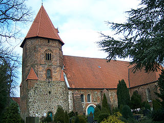
The Saint Mary's Church is a Lutheran parish church used and owned by the Lutheran parish in Himmelpforten, Lower Saxony, Germany. The Himmelpforten parish forms part of the Stade deanery (Kirchenkreis) within the Stade diocese of the Lutheran Church of Hanover. The church was completed in 1738 and covers the eastern half of the foundations of the demolished abbey church of the former Himmelpforten Convent.

<span class="mw-page-title-main">Neuenwalde Convent</span> Lutheran convent in Lower Saxony, Germany

The Neuenwalde Convent is a Lutheran damsels' convent in Neuenwalde, a locality of Geestland, Lower Saxony, Germany.

References

  1. Kim Fürwentsches wird neuer Bürgermeister in Lilienthal, Weser Kurier, 9 October 2022.
  2. "LSN-Online Regionaldatenbank, Tabelle A100001G: Fortschreibung des Bevölkerungsstandes, Stand 31. Dezember 2021" (in German). Landesamt für Statistik Niedersachsen.
  3. Staff (2002). "Astronomical Serendipity". NASA JPL. Archived from the original on February 6, 2012. Retrieved May 20, 2011.
  4. "Home". ganztagsschule-lilienthal.de.
  5. "Home". gymnasium-lilienthal.de.
  6. "Christoph-Tornée-Schule, Lilienthal - CTS". Archived from the original on 2015-08-01. Retrieved 2015-05-03.
  7. http://www.verwaltungsgeschichte.de/osterholz.html
  8. Statistisches Bundesamt (Hrsg.): Historisches Gemeindeverzeichnis für die Bundesrepublik Deutschland. Namens-, Grenz- und Schlüsselnummernänderungen bei Gemeinden, Kreisen und Regierungsbezirken vom 27. 5. 1970 bis 31. 12. 1982. W. Kohlhammer, Stuttgart und Mainz 1983, ISBN   3-17-003263-1, S. 244.