Lincoln (proposed Northwestern state)

Last updated

Lincoln's proposed location in the United States Lincoln in United States.svg
Lincoln's proposed location in the United States

Lincoln is the name for several proposals to create a new state in the Northwest United States. The proposed State has been defined in multiple ways, but can generally be said to be coterminous with the region known as the Inland Northwest. The proposed state was named in honor of Abraham Lincoln, who was president during the American Civil War. His name had also been proposed for the states that were eventually named North Dakota and Wyoming.

Contents

Lincoln in the Northwest

Proposed flag Flag of Lincoln State.svg
Proposed flag

The State of Lincoln has been proposed to consist of the Panhandle of Idaho and Eastern Washington (that is, east of the Cascade Mountains). Other than Lincoln, the names "Columbia" and "Eastern (or East) Washington" were proposed to be used for the state. [1] It was first proposed by Idaho in 1865, when the capital was moved from Lewiston in December 1864 to its present-day location of Boise in January 1865, in an Idaho greatly reduced in land area. The original Idaho Territory, from a bill signed by President Lincoln in March 1863, was declared by Governor William H. Wallace in Lewiston, July 4, 1863, and included present-day Idaho, and virtually all of present-day Montana and Wyoming, making it larger in land area than Texas.

Montana was made a territory in May 1864 and the Panhandle was specifically excluded in order to prevent Lewiston, west of both the Continental Divide along the crest of the Rockies and of the Bitterroot Range, from remaining the capital. The reasoning was that Lewiston sits on the western edge, across the Snake River from Washington, whereas Montana stretches to North Dakota.

In the mid and late 1860s, there was a proposal centered on Lewiston in northern Idaho for a Columbia Territory to be formed in the Inland Northwest from parts of what is now eastern Washington, northern Idaho and western Montana. [2] In 1901 another proposal was made, this time to combine the Idaho Panhandle with Eastern Washington to create the state of Lincoln. A third proposal was popularized in the late 1920s to consist of eastern Washington, northern Idaho and western Montana to the Continental Divide. From the Washington end, proposals have been made as recently as 1996, 1999 and 2005. Idaho saw a corresponding campaign for North Idaho, financed by the sale of T-shirts reading "North Idaho – A State of Mind".

Areas proposed for inclusion

North Idaho

While the disconnection between Western Washington and Eastern Washington is well known and documented, North Idaho has a similar dynamic in which its residents often feel disconnected from the state's political center in Boise. The Idaho Panhandle is most often considered to be the ten northernmost counties in the state—Boundary, Bonner, Benewah, Clearwater, Idaho, Kootenai, Latah, Lewis, Nez Perce, and Shoshone. These counties are separated from Southern Idaho by the Salmon River and observe Pacific Time, unlike the rest of the state, which uses Mountain Time.

Parallel suggestions of a "State of Kootenai" have been made, referring to a proposed union of the six northernmost counties of Idaho, and the six westernmost counties of Montana, creating a geographically, politically, and ecologically connected state of 524,888 residents, putting it ahead of other states such as Wyoming. [1]

Eastern Washington and eastern Oregon

Other conceptions of a potential "State of Lincoln" have been rendered, specifically a possible combination of eastern Washington and eastern Oregon.

The people of Eastern Oregon also often express the same frustration with being coupled with Portland and the region west of the Cascades that Eastern Washingtonians do with respect to Seattle. This proposed coupling would create one of the largest states by area in the country, stretching all the way from the eastern foothills of the Cascade Mountain Range to the border with Idaho in the east.

Proposals

The state legislatures for Idaho and Washington have seen bills proposing secession or splintering. Idaho would not go along as at the time the Panhandle generated more tax revenue per capita than the south. If combined with the proposed State of Jefferson, which overlaps a proposed Oregon-Washington "State of Lincoln" in southeastern Oregon and is proposed for many of the same reasons, it would create a state that is even larger.

The Inland Northwest region roughly corresponds to the area that might comprise such a State of Lincoln. The largest city would be Spokane, Washington, which is presently Washington's second largest and the greater Spokane area is the third largest population base in the northwestern US behind Seattle and Portland.

A Spokane proposal in 1907 called for a new state "Lincoln" to be created from eastern Washington, northeastern Oregon, and northern Idaho. Oregon and Washington's eastern boundary would have been shifted westward to 120° W, aligning with California's eastern boundary. Idaho's northern boundary would have been shifted southward to 45° N, aligning with Wyoming's northern boundary. [3]

Alternative name for current states

North Dakota

It was proposed to split Dakota Territory into northern and southern halves while being considered for statehood in the 1880s. Republicans in the Senate suggested the name "Lincoln" for the northern half, despite objections from residents from the territory, which drew strong objection from the Democrats. [4] Ultimately the territory was admitted in 1889 as two states, North Dakota and South Dakota.

Wyoming

When the 1868 bill [5] to form Wyoming Territory was first discussed in the U.S. Senate, an amendment was proposed that would have changed its name to Lincoln Territory after the assassinated U.S. president Abraham Lincoln. [1] The new name was supported by the Senate Committee on Territories, however it started a debate that scrutinized both "Lincoln" and "Wyoming", with several members preferring local and Indian names. Multiple senators objected to naming a territory after a single man, acknowledging Washington Territory (named in 1853 for George Washington) as the sole exception. [1] "Wyoming" was the simple English transliteration of the Lenape Indian tribe's word for "large plains", [6] which was considered descriptive of the land but undesirable due to its distant origin in Pennsylvania. The bill eventually passed both houses of Congress with the name "Wyoming Territory", and the Wyoming name was retained when statehood was achieved in 1890.

See also

Related Research Articles

<span class="mw-page-title-main">Idaho</span> U.S. state

Idaho is a landlocked state in the Mountain West subregion of the United States. It shares a small portion of the Canada–United States border to the north, with the province of British Columbia. It borders Montana and Wyoming to the east, Nevada and Utah to the south, and Washington and Oregon to the west. The state's capital and largest city is Boise. With an area of 83,570 square miles (216,400 km2), Idaho is the 14th largest state by land area. With a population of approximately 1.8 million, it ranks as the 13th least populous and the 7th least densely populated of the 50 U.S. states.

<span class="mw-page-title-main">Big Sky Conference</span> American collegiate athletic conference

The Big Sky Conference is a collegiate athletic conference affiliated with the NCAA's Division I with football competing in the Football Championship Subdivision. As of 2023, full member institutions are located in the states of Arizona, California, Colorado, Idaho, Montana, Oregon, Utah, and Washington. Two affiliate members from California are football–only participants.

<span class="mw-page-title-main">Scouting in Idaho</span>

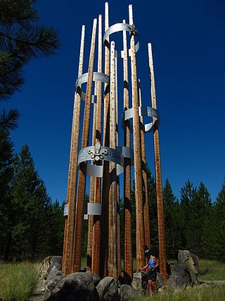
Scouting in Idaho has a long history, from the 1910s to the present day, serving thousands of youth in programs that suit the environment in which they live.

<span class="mw-page-title-main">Scouting in Washington (state)</span> Overview of the Scouting programs in the state of Washington

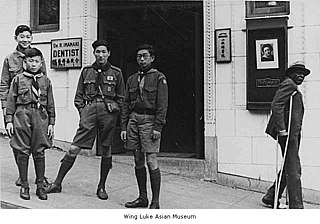
Scouting in Washington has a long history, from the 1910s to the present day, serving thousands of youth in programs that suit the environment in which they live.

<span class="mw-page-title-main">Great Northern Railway (U.S.)</span> Defunct American Class I railroad

The Great Northern Railway was an American Class I railroad. Running from Saint Paul, Minnesota, to Seattle, Washington, it was the creation of 19th-century railroad entrepreneur James J. Hill and was developed from the Saint Paul & Pacific Railroad. The Great Northern's route was the northernmost transcontinental railroad route in the U.S.

<span class="mw-page-title-main">Inland Northwest</span> Region

The Inland Northwest, historically and alternatively known as the Inland Empire, is a region of the American Northwest centered on the Greater Spokane, Washington Area, encompassing all of Eastern Washington and North Idaho. Under broader definitions, Northeastern Oregon and Western Montana may be included in the Inland Northwest. Alternatively, stricter definitions may exclude Central Washington and Idaho County, Idaho.

The Territory of Washington was an organized incorporated territory of the United States that existed from March 2, 1853, until November 11, 1889, when the territory was admitted to the Union as the State of Washington. It was created from the portion of the Oregon Territory north of the lower Columbia River and north of the 46th parallel east of the Columbia. At its largest extent, it also included the entirety of modern Idaho and parts of Montana and Wyoming, before attaining its final boundaries in 1863.

<span class="mw-page-title-main">Wyoming Territory</span> Former organized incorporated territory of the United States (1868–1890)

The Territory of Wyoming was an organized incorporated territory of the United States that existed from July 25, 1868, until July 10, 1890, when it was admitted to the Union as the State of Wyoming. Cheyenne was the territorial capital. The boundaries of the Wyoming Territory were identical to those of the modern State of Wyoming.

<span class="mw-page-title-main">Idaho Territory</span> Territory of the U.S. between 1863–1890

The Territory of Idaho was an organized incorporated territory of the United States that existed from March 3, 1863, until July 3, 1890, when the final extent of the territory was admitted to the Union as Idaho.

<span class="mw-page-title-main">Eastern Washington</span> Geographic region in Washington, United States

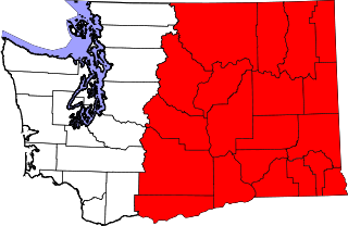
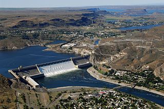
Eastern Washington is the region of the U.S. state of Washington located east of the Cascade Range. It contains the city of Spokane, the Tri-Cities, the Columbia River and the Grand Coulee Dam, the Hanford Nuclear Reservation and the fertile farmlands of the Yakima Valley and the Palouse. Unlike in Western Washington, the climate is dry, including some desert environments.
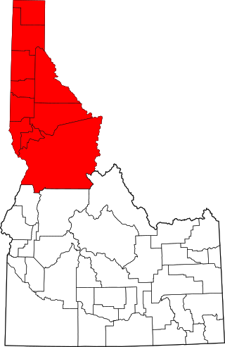
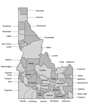
<span class="mw-page-title-main">Idaho panhandle</span> Region of the U.S. state of Idaho

The Idaho panhandlelocally known as North Idahoor Northern Idaho—is a salient region of the U.S. state of Idaho encompassing the state's 10 northernmost counties: Benewah, Bonner, Boundary, Clearwater, Idaho, Kootenai, Latah, Lewis, Nez Perce, and Shoshone. The panhandle is bordered by the state of Washington to the west, Montana to the east, and the Canadian province of British Columbia to the north. The Idaho panhandle, along with Eastern Washington, makes up the region known as the Inland Northwest, headed by its largest city, Spokane, Washington.

<span class="mw-page-title-main">Northwestern United States</span> Geographical region of the United States

The Northwestern United States, also known as the American Northwest or simply the Northwest, is an informal geographic region of the United States. The region consistently includes the states of Oregon, Washington, Idaho, Montana and Wyoming. Some sources include Southeast Alaska in the Northwest. The related but distinct term "Pacific Northwest" generally excludes areas from the Rockies eastward, whereas the term "Inland Northwest" excludes areas west of the Cascades.

<span class="mw-page-title-main">Mullan Road</span> United States historic place

Mullan Road was the first wagon road to cross the Rocky Mountains to the Inland of the Pacific Northwest. It was built by U.S. Army troops under the command of Lt. John Mullan, between the spring of 1859 and summer 1860. It led from Fort Benton, which at the time was in the Dakota Territory, then Idaho Territory from July 1863, and into Montana Territory beginning in May 1864. The road eventually stretched all the way from Fort Walla Walla, Washington Territory, near the Columbia River to the navigational head of the Missouri River, which at the time was the farthest inland port in the world). The road previewed the route approximately followed by modern-day Interstate 15 and Interstate 90 through present-day Montana, Idaho, and Washington.

<span class="mw-page-title-main">Cascadia (bioregion)</span> Bioregion in North America

The concept of Cascadian bioregionalism is closely identified with the environmental movement. In the early 1970s, the contemporary vision of bioregionalism began to be formed through collaboration between natural scientists, social and environmental activists, artists and writers, community leaders, and back-to-the-landers who worked directly with natural resources. A bioregion is defined in terms of the unique overall pattern of natural characteristics that are found in a specific place. The main features are generally obvious throughout a continuous geographic terrain and include a particular climate, local aspects of seasons, landforms, watersheds, soils, and native plants and animals. People are also counted as an integral aspect of a locale's life, as can be seen in the ecologically adaptive cultures of early inhabitants, and in the activities of present-day reinhabitants who attempt to harmonize in a sustainable way with the place where they live.

<span class="mw-page-title-main">Northern Transcon</span> Railroad route in the United States

The Northern Transcon, a route operated by the BNSF Railway, traverses the most northerly route of any railroad in the western United States. This route was originally part of the Chicago, Burlington and Quincy Railroad, Northern Pacific Railway, Great Northern Railway and Spokane, Portland and Seattle Railway systems, merged into the Burlington Northern Railroad system in 1970.

<span class="mw-page-title-main">Geography of Idaho</span> Overview of the Geograpny of Idaho

The U.S. state of Idaho borders six other U.S. states and one Canadian province. The states of Washington and Oregon are to the west, Nevada and Utah are to the south, and Montana and Wyoming are to the east. Idaho also shares a short border with the Canadian province of British Columbia to the north.

<span class="mw-page-title-main">U.S. Route 95 in Idaho</span> Section of U.S. Highway in Idaho, United States

In the U.S. state of Idaho, U.S. Route 95 (US-95) is a north–south highway near the western border of the state, stretching from Oregon to British Columbia for over 538 miles (866 km); it was earlier known in the state as the North and South Highway.

<span class="mw-page-title-main">Time in Idaho</span> Time zones in North America

The U.S. state of Idaho is covered by two time zones, as described below. All locations observe daylight saving time.

References

  1. 1 2 3 4 The Congressional Globe: Senate, 40th Congress, 2nd Session. pp. 2792–2794.
  2. Merle W. Wells. "Territorial Government in the Inland Empire: The Movement to Create Columbia Territory, 1864-69." The Pacific Northwest Quarterly. Vol. 44, No. 2 (April 1953), pp. 80-87.
  3. "Spokane People Demand Brand New Western State". The Washington Times. Washington, DC. April 22, 1907. p. 3.
  4. Louis Arthur Coolidge (1910). An old-fashioned senator: Orville H. Platt, of Connecticut. G.P. Putnam's Sons. p.  140.
  5. To provide a temporary government for the Territory of Wyoming". S. 357. 40th Congress, 2nd Session. 1868. p.  15. To provide a temporary government for the Territory of Wyoming.
  6. Urbanek, Mae. Wyoming Place Names. Missoula, Montana: Mountain Press Publishing Company, 1988.