Linton-on-Ouse

Last updated

Linton-on-Ouse
Linton on Ouse - geograph.org.uk - 186503.jpg
Linton on Ouse
North Yorkshire UK location map (2023).svg
Red pog.svg
Linton-on-Ouse
Location within North Yorkshire
Population1,201 (2011 census) [1]
OS grid reference SE493607
Civil parish
  • Linton-on-Ouse [2]
Unitary authority
Ceremonial county
Region
Country England
Sovereign state United Kingdom
Post town YORK
Postcode district YO30
Police North Yorkshire
Fire North Yorkshire
Ambulance Yorkshire
UK Parliament
List of places
UK
England
Yorkshire
54°02′26″N1°14′54″W / 54.0405°N 1.2483°W / 54.0405; -1.2483

Linton-on-Ouse is a village and civil parish in the Hambleton District of North Yorkshire, England, about eight miles north-west of York. It lies on the north bank of the River Ouse.

Contents

History

The village is mentioned in the Domesday Book as Luctone in the Bulford Hundred. The manor at this time was split between Thorfin of Ravensworth and Thorn of Linton. Afterwards, the manor was granted to Robert of Mortain. [3] The manor passed to Thomas de Ros, 4th Baron de Ros, in the 14th century and remained in the family until the mid-16th century. In the early 18th century, the manorial rights were sold to University College, Oxford. The university built a school in the village in 1871. [4] [5]

In the mid-18th century, Acts of Parliament were passed to make the River Ouse navigable that included the building of a lock at Linton-on-Ouse, which is now a Grade II listed building. [6]

There was a Catholic chapel in the village between 1700 and 1855. [4]

Since 1937, Linton-on-Ouse has been home to a Royal Air Force station, RAF Linton-on-Ouse. Since 1957, the main role of the airfield has been the training of pilots, and with the main flying training ceasing from 2019, [7] the Military Air Traffic Zone was rescinded in December 2020. [8]

In the summer of 1960 and 1961, the perimeter track of the airfield was used to form the 1.7-mile (2.7 km) Linton-on-Ouse Motor Racing circuit. [9]

In April 2022, the government announced its intention to convert the former RAF base into a reception, accommodation and processing centre for asylum seekers as a way of defraying the £4.7 million per day cost of hotels being used. [10]

Asylum reception centre

On 14 April 2022, the Home Office announced that the disused RAF station at Linton-on-Ouse would be converted to house 1,500 asylum-seekers, creating the first in a series of new ‘Greek-style' asylum reception centres designed to cut the cost of placing asylum-seekers in hotels. The announcement came as part of a wider plan centred around a £120 million agreement with the government of Rwanda whereby asylum-seekers arriving in the UK could be flown 4,000 miles away to have their asylum claims processed there. [11]

Local residents set up a campaign group [12] with the slogan “Wrong plan, Wrong place”. [13] They said that there had been no prior consultation and that their opposition was being met with silence from the Home office. [14] They were supported by Kevin Hollinrake, Conservative MP for Thirsk and Malton, who said the Home Office had “failed to follow its own guidance on the location of such a facility, which said that asylum-seekers should be placed in urban areas".

He also said that the government had not consulted with the local council. [15] Within two weeks of the Home Office's announcement, Hambleton District Council had instructed lawyers to mount a legal challenge to the plans. [16] The council served a Planning Contravention Notice (PCN) to determine whether the Home Office’s plans breached planning control. [17] On 19 May 2022, Conservative-led North Yorkshire County Council overwhelmingly passed a vote of no confidence in the Home Office, based on its “cack-handed” handling of the plans. [18]

On 9 August 2022, defence secretary Ben Wallace announced that the Ministry of Defence was withdrawing its offer of the land from the Home Office, ending the plans for an asylum reception centre. [19] The future of the disused RAF station remains uncertain.

Governance

The village lies within the Thirsk and Malton Parliamentary constituency. It also lies within the Shipton ward of Hambleton District Council and the Stillington electoral division of North Yorkshire County Council. [20]

Geography

The nearest settlements are Newton-on-Ouse 1.2 miles (1.9 km) to the south-east, Aldwark 2.5 miles (4.0 km) to the north-west and Thorpe Underwood 2.1 miles (3.4 km) to the south-west. Sandwath Beck joins Shorn Dike to the north-east of the village before flowing into the River Kyle just to the east of the school. [20]

The 1881 UK Census recorded the population as 296. [4] The 2001 UK Census recorded the population as 1,024, of which 723 were over the age of sixteen years. There were 388 dwellings, of which 134 were detached. [21]

Climate

Climate data for Linton on Ouse (14 m elevation) 1981–2010
MonthJanFebMarAprMayJunJulAugSepOctNovDecYear
Mean daily maximum °C (°F)6.9
(44.4)
7.5
(45.5)
10.0
(50.0)
12.6
(54.7)
16.0
(60.8)
18.8
(65.8)
21.2
(70.2)
20.8
(69.4)
18.0
(64.4)
13.9
(57.0)
9.7
(49.5)
6.9
(44.4)
13.6
(56.5)
Mean daily minimum °C (°F)0.8
(33.4)
0.9
(33.6)
2.4
(36.3)
3.9
(39.0)
6.7
(44.1)
9.7
(49.5)
11.8
(53.2)
11.6
(52.9)
9.5
(49.1)
6.6
(43.9)
3.3
(37.9)
0.9
(33.6)
5.7
(42.3)
Average rainfall mm (inches)52.7
(2.07)
39.9
(1.57)
44.9
(1.77)
50.1
(1.97)
43.8
(1.72)
58.0
(2.28)
53.2
(2.09)
62.4
(2.46)
49.6
(1.95)
57.7
(2.27)
57.8
(2.28)
55.8
(2.20)
626.0
(24.65)
Average rainy days (≥ 1.0 mm)11.19.19.59.39.19.38.910.08.610.411.310.7117.2
Source: metoffice.gov.uk [22]

Public services

College Arms, Linton on Ouse College Arms, Linton on Ouse - geograph.org.uk - 1655389.jpg
College Arms, Linton on Ouse

Education is provided at Linton-on-Ouse Primary School. The school is within the catchment area of Easingwold School for secondary education. [23]

There is a village store, public house and several local businesses. The village is served by the bus service that runs between York and Easingwold. [24]

Twinning

In 2012 the village started formal twinning procedures with Montcony in France. This is linked to the loss of a Halifax Bomber and crew, stationed here during World War II, in the French village and the respect shown by those villagers to the remains of the crew. [25]

Related Research Articles

<span class="mw-page-title-main">Sowerby, North Yorkshire</span> Village and civil parish in North Yorkshire, England

Sowerby is a village, electoral ward and civil parish in the Hambleton District of North Yorkshire, England immediately south of the neighbouring market town of Thirsk. Although the boundary between the two parishes runs very close to Thirsk town centre, the village retains its own identity and has a separate Parish Council. The author James Herriot lived in the village.

<span class="mw-page-title-main">Easingwold</span> Market town and civil parish in North Yorkshire, England

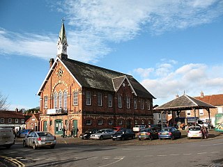
Easingwold is a market town and civil parish in North Yorkshire, England. Historically, part of the North Riding of Yorkshire, it had a population of 4,233 at the 2001 census, increasing to 4,627 at the 2011 Census. It is located about 12 miles (19 km) north of York, at the foot of the Howardian Hills.

<span class="mw-page-title-main">Hambleton District</span> Former local government district in England

Hambleton was a local government district in North Yorkshire, England. The administrative centre was Northallerton, and the district included the outlying towns and villages of Bedale, Thirsk, Great Ayton, Stokesley, and Easingwold.

<span class="mw-page-title-main">Thirsk</span> Market town and civil parish in North Yorkshire, England

Thirsk is a market town and civil parish in North Yorkshire, England; it is known for its racecourse, quirky yarn bombing displays and depiction as local author James Herriot's fictional Darrowby.

<span class="mw-page-title-main">RAF Linton-on-Ouse</span> Royal Air Force base in Yorkshire, England

Royal Air Force Linton-on-Ouse or more simply RAF Linton-on-Ouse is a former Royal Air Force station at Linton-on-Ouse in North Yorkshire, England, 10 miles (16 km) north-west of York. It had satellite stations at RAF Topcliffe and Dishforth Airfield.

<span class="mw-page-title-main">Sutton-on-the-Forest</span> Village and civil parish in North Yorkshire, England

Sutton-on-the-Forest is a village and civil parish in North Yorkshire, England. It is 8 miles (13 km) north of York and 4.4 miles (7 km) south-east of Easingwold.

<span class="mw-page-title-main">Youlton</span> Village and civil parish in North Yorkshire, England

Youlton is a village and civil parish in Hambleton District of North Yorkshire, England. It is situated approximately 5 miles (8 km) south-west of Easingwold and 11 miles (18 km) from York. The population of the civil parish at the 2011 census was fewer than 100. Details are included in the civil parish of Aldwark.

<span class="mw-page-title-main">Aldwark, Hambleton</span> Village and civil parish in North Yorkshire, England

Aldwark is a village and civil parish in the Hambleton District of North Yorkshire, England. It is situated on the River Ouse about 14 miles from York. The village lies within a conservation area. At the 2001 census it had a population of 116 increasing to 308 at the 2011 Census.

<span class="mw-page-title-main">Alne, North Yorkshire</span> Village and civil parish in North Yorkshire, England

Alne is a village and civil parish in the Hambleton District of North Yorkshire, England, about twelve miles north-west of York and four miles from Easingwold. The parish has a population of 711, increasing to 756 at the 2011 census.

<span class="mw-page-title-main">Newton-on-Ouse</span> Village and civil parish in North Yorkshire, England

Newton-on-Ouse is a village and civil parish in the Hambleton District of North Yorkshire, England, about 7 miles (11 km) north-west of York. It lies on the east bank of the River Ouse

<span class="mw-page-title-main">Crayke</span> Village and civil parish in North Yorkshire, England

Crayke is a village and civil parish in North Yorkshire, England, about 2 miles (3.2 km) east of Easingwold.

<span class="mw-page-title-main">Raskelf</span> Village and civil parish in North Yorkshire, England

Raskelf is a village and civil parish in North Yorkshire, England. The electoral roll has a population of around 400 measured at 519 in the 2011 census.

<span class="mw-page-title-main">Oulston</span> Village and civil parish in North Yorkshire, England

Oulston is a village and civil parish in Hambleton district of North Yorkshire, England. It lies about 3 miles (5 km) north-east of Easingwold. Remains of a Roman villa have been found in the area. The village is within the Howardian Hills Area of Outstanding Natural Beauty

<span class="mw-page-title-main">Husthwaite</span> Village and civil parish in North Yorkshire, England

Husthwaite is a village and civil parish in Hambleton district of North Yorkshire, England. It is situated approximately 2.5 miles (4 km) north from Easingwold.

<span class="mw-page-title-main">Tholthorpe</span> Village and civil parish in North Yorkshire, England

Tholthorpe is a village and civil parish in the Hambleton district of North Yorkshire, England. It is situated approximately 4 miles (6 km) south-west of Easingwold and 12 miles (19 km) north-west of York.

<span class="mw-page-title-main">River Kyle</span> River in North Yorkshire, England

The River Kyle is a small river in North Yorkshire, England. At just under 6 miles (9.7 km) long, it is one of the shortest classified main rivers in the country.

<span class="mw-page-title-main">Tollerton, North Yorkshire</span> Village and civil parish in North Yorkshire, England

Tollerton is a village and civil parish in the Hambleton District of North Yorkshire, England. Tollerton is situated close to both the A19 and the River Kyle about 4 miles (6 km) south of Easingwold and 10 miles (16 km) north of York.

<span class="mw-page-title-main">Hutton Sessay</span> Village and civil parish in North Yorkshire, England

Hutton Sessay is a village and civil parish in the Hambleton district of North Yorkshire, England. In 2013 the population of the civil parish was estimated at 100. The village is situated just west of the A19 between Thirsk and Easingwold.

<span class="mw-page-title-main">Thirsk and Malton (UK Parliament constituency)</span> Parliamentary constituency in the United Kingdom

Thirsk and Malton is a constituency in North Yorkshire represented in the House of Commons of the UK Parliament since 2015 by Kevin Hollinrake, a Conservative.

<span class="mw-page-title-main">Ebberston</span> Village in North Yorkshire, England

Ebberston is a village and former civil parish, now in the parish of Ebberston and Yedingham in North Yorkshire, England, and is 34 miles (55 km) east from the county town of Northallerton. In 1961 the parish had a population of 466.

References

  1. UK Census (2011). "Local Area Report – Linton-on-Ouse Parish (1170216881)". Nomis. Office for National Statistics . Retrieved 30 April 2018.
  2. "Parish Council | Linton-on-Ouse". lintononouse.com. Retrieved 11 July 2021.
  3. Linton-upon-Ouse in the Domesday Book . Retrieved 5 January 2013.
  4. 1 2 3 Bulmer's Topography, History and Directory (Private and Commercial) of North Yorkshire 1890. S&N Publishing. 1890. pp. 767, 768. ISBN   1-86150-299-0.
  5. "History" . Retrieved 5 January 2013.
  6. "Lock Listing" . Retrieved 5 January 2013.
  7. "Final flights as RAF base prepares for closure". The Northern Echo. 29 October 2019. Retrieved 11 July 2021.
  8. "Removal of RAF Linton on Ouse MATZ/ATZ | Civil Aviation Authority" . Retrieved 11 July 2021.
  9. Peter Swinger (2008). Motor Racing Circuits in England : Then & Now. Ian Allan Publishing. ISBN   978-0-7110-3104-3.
  10. Former RAF Linton-on-Ouse to become asylum centre BBC News , 14 April 2022. Retrieved 14 April 2022
  11. "Quiet Yorkshire village split as hundreds of refugees about to arrive at new asylum centre". Yorkshire Live. 14 April 2022. Retrieved 19 January 2023.
  12. "Linton-on-Ouse: Meet the villagers fighting plans for asylum centre in North Yorkshire". The Yorkshire Post. 15 June 2022. Retrieved 19 January 2023.
  13. "Linton on Ouse asylum centre: 'wrong plan in wrong place'". The Northern Echo. 13 May 2022. Retrieved 19 January 2023.
  14. "Tiny Yorkshire village where 70% of residents will be asylum seekers met with 'silence' over complaints". Examiner Live. 13 May 2022. Retrieved 19 January 2023.
  15. "Tory MP asks government to halt North Yorkshire asylum centre plan". BBC News. 21 April 2022. Retrieved 19 January 2023.
  16. "Statement in response to Government plans for an Asylum seekers centre at Linton-on-Ouse". Hambleton District Council. 27 April 2022. Retrieved 19 January 2023.
  17. "Council sends pre legal action letter to Home Office over Linton Asylum plan". YorkMix. 5 May 2022. Retrieved 19 January 2023.
  18. "North Yorkshire County Council slams Home Office". York Press. 19 May 2022. Retrieved 19 January 2023.
  19. "Controversial Yorkshire village asylum centre 'withdrawn' as locals say they are 'delighted". YorkshireLive. 9 August 2022. Retrieved 19 January 2023.
  20. 1 2 "OpenData support | OS Tools & Support".
  21. UK Census (2001). "Local Area Report – Linton-on-Ouse Parish (36UC093)". Nomis. Office for National Statistics . Retrieved 11 July 2021.
  22. "Climate Normals 1981–2010". Met Office. Retrieved 23 February 2021.
  23. "Secondary admission arrangements for the Northallerton area". North Yorkshire County Council. North Yorkshire County Council. Retrieved 12 December 2017.
  24. "Services" . Retrieved 5 January 2013.
  25. "Local History" . Retrieved 5 January 2013.