Lion Rock Tunnel

Last updated

Lion Rock Tunnel
獅子山隧道
Lion Rock Tunnel 201605.jpg
Entrance of the Lion Rock Tunnel in Sha Tin, Hong Kong
Overview
LocationThrough Lion Rock, connecting Kowloon Tong to Tai Wai in Hong Kong
Coordinates 22°21′21″N114°10′22″E / 22.35583°N 114.17278°E / 22.35583; 114.17278 Coordinates: 22°21′21″N114°10′22″E / 22.35583°N 114.17278°E / 22.35583; 114.17278
StatusActive
RouteHK Route1.svg Route 1
Start Kowloon Tong
End Hin Tin
Operation
Work begunJanuary 1962;59 years ago (1962-01)
Opened14 November 1967;53 years ago (1967-11-14) (Lion Rock Tunnel)
18 January 1978;43 years ago (1978-01-18) (Second Lion Rock Tunnel)
Owner Hong Kong Government
OperatorGreater Lucky (H.K.) Co., Ltd
TrafficVehicular
TollYes (HK$8)
Vehicles per day90,608
Technical
Design engineerYoung Au Young
Length1.4 kilometres (0.87 mi)
No. of lanes 4 lanes (2 lanes per direction)
Operating speed70 kilometres per hour (43 mph)
Chinese name
Traditional Chinese 獅子山隧道
Simplified Chinese 狮子山隧道
Lion Rock Tunnel toll plaza, on the Sha Tin side. Lion Rock Tunnel Toll Plaza.jpg
Lion Rock Tunnel toll plaza, on the Sha Tin side.
New Kowloon side. The Second Lion Rock Tunnel is on the left, the "old" tunnel is on the right. Lion Rock is visible in the top right corner. HK Lion Rock Tunnel Kowloon Section.jpg
New Kowloon side. The Second Lion Rock Tunnel is on the left, the "old" tunnel is on the right. Lion Rock is visible in the top right corner.

The Lion Rock Tunnel, the first major road tunnel in Hong Kong, is a twin-bored toll tunnel, connecting Hin Tin, Sha Tin in the New Territories and New Kowloon near Kowloon Tong. It has two southbound lanes, and there are two northbound lanes in the Second Lion Rock Tunnel, with the toll booths located at the Sha Tin end. They are vital components of Route 1.

Contents

History

The construction of Lion Rock Tunnel started in January 1962. [1] The tunnel was opened on 14 November 1967, as a 1.43 km dual-one single bore tunnel. This tunnel is often described as a by-product of the Plover Cove Scheme, which was a project to build a water supply tunnel through the range of hills separating New Kowloon and the rest of the New Territories. [2] The tunnel was designed by Young Au Young, a graduate of Lingnan and civil engineer [3] [4] from Shunde.[ citation needed ]

The government later saw the need for another road link between New Kowloon and Sha Tin when it decided to develop the latter as a new town. The Second Lion Rock Tunnel, which is 1.41 km long and situated to the west of, and lying parallel to, the old tunnel, was opened to traffic on 18 January 1978.

The new tunnel serves northbound traffic towards Sha Tin, while the old one serves southbound traffic towards Kowloon. Traffic in both directions share one of the tunnels when the other undergoes maintenance.

Management

Since 1993, Serco has been contracted to manage, operate and maintain the tunnel, having successfully retained the contract in 1996 and 2000. [5]

The Tunnel has achieved both ISO 9001 and OHASA18001 in 2004. The toll to traverse the Lion Rock Tunnel is HK$8 each way.

On 23 April 2012, Greater Lucky (H.K.) Company Limited successfully bid the contract and took over the management with effect from 1 August 2012.

Renovation of the tunnel

As the facilities within the tubes of Lion Rock Tunnel suffered from serious deterioration due to ageing, as well as broken concrete on the road surface which caused bumping when vehicles pass through, the Highways Department decided to undergo renovation works upon the tunnels in 2008. It will extend the lives of the tunnels for around 80 years more.

However, the renovation may cause even more serious congestion of the tunnels and may change the starting time for one-tube-two-way traffic (using one tube only for both direction of traffic) from 12 am to 9 or 10 pm. The fire-resisting shields on the wall of the tunnels and the ceilings would be renovated, while the words "LION ROCK TUNNEL" and its Chinese counterparts would be retained on the sides of the entrances and exits of the tunnels.

Current usage

With the rapid development of the new towns, the tunnels have already reached its saturation flow just like Cross-Harbour Tunnel. The flow was eased by other tunnels being put into service later, such as Shing Mun Tunnels, Tate's Cairn Tunnel, Tsing Sha Highway. Nonetheless the convenience of its connection and directness, with a lower fee than the Tate's Cairn Tunnel, Lion Rock Tunnel contributes to the highest daily average vehicles flow of all non-harbour-crossing tunnels. 90,608 vehicles used the tunnels everyday on average in 2014. [6]

See also

Related Research Articles

Kowloon Area of Hong Kong

Kowloon is an urban area in Hong Kong comprising the Kowloon Peninsula and New Kowloon. With a population of 2,019,533 and a population density of 43,033/km2 in 2006, it is the most populous urban area in Hong Kong. The peninsula's area is about 47 km2 (18 sq mi).

Sha Tin District District in New Territories, Hong Kong

Sha Tin District is one of the 18 districts of Hong Kong. As one of the 9 districts located in the New Territories, it covers the areas of Sha Tin, Tai Wai, Ma On Shan, Fo Tan, Siu Lek Yuen and Ma Liu Shui. The district is the most populous district in Hong Kong, with a population of 659,794 as per 2016 by-census, having a larger population than many countries or dependencies including Iceland, Malta, Montenegro and Brunei.

Eastern Harbour Crossing Tunnel crossing Victoria Harbour, Hong Kong

The Eastern Harbour Crossing, abbreviated as "EHC", is a combined road-rail tunnel that crosses beneath Victoria Harbour in Hong Kong. Opened on 21 September 1989, it connects Quarry Bay, Hong Kong Island and Cha Kwo Ling, Kowloon East.

Tates Cairn Highway Road in Hong Kong

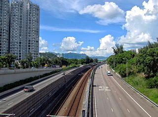
Tate's Cairn Highway, opened on 26 June 1991, is a dual 3-lane expressway in Hong Kong. It links Tate's Cairn Tunnel and Ma Liu Shui Interchange, forming a part of Route 2.

Sha Tin Road

Sha Tin Road, opened on 6 November 1984, is a dual-2 lane expressway in Hong Kong. It links Lion Rock Tunnel Road and Tai Po Road — Sha Tin, forming a part of Route 1.

City One Housing estate in Sha Tin, New Territories

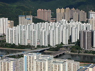
City One Shatin is a residential precinct in Sha Tin, New Territories, Hong Kong. The estate occupies approximately 1,800,000 square feet of land. The estate was named City One as it is on Lot 1, Shatin Town. It has a census area population of 24,758 people. City One is the largest private residential estate in Sha Tin District. There are a total of 52 blocks of residential buildings with 10,642 units. Each tower is about 30 storeys with units ranging from 389 square feet (36.1 m2) to an area of 1,018 square feet (94.6 m2), offering different floor plans.

Route 2 (Hong Kong) Road in Hong Kong

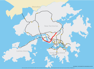
Route 2 of Hong Kong is a series of expressways that runs from Quarry Bay of Hong Kong Island to Ma Liu Shui of the New Territories East, formerly known as route 6, and renamed as route 2 in 2004 under the route numbering scheme proposed in the same year. Route 2 consists of 4 parts, from South to North:

Route 1 (Hong Kong) Major road in Hong Kong

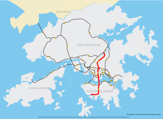
Route 1 is a major artery in Hong Kong that runs in a generally north-south direction, connecting Aberdeen with Sha Tin.

Sha Tin Neighbourhood in New Territories, Hong Kong, China

Sha Tin, also spelt Shatin, is a neighbourhood along Shing Mun River in the eastern New Territories, Hong Kong. Administratively, it is part of the Sha Tin District. Sha Tin is one of the neighbourhoods of the Sha Tin New Town project.

Sha Tin New Town satellite town in Hong Kong, China

Sha Tin New Town, or known as Sha Tin-Ma On Shan New Town or Sha Tin Town is one of the satellite towns and new towns of Hong Kong. It is within the Sha Tin District, the New Territories. The New Town covers the neighbourhoods such as Sha Tin, Tai Wai, Fo Tan, Tai Shui Hang, Ma On Shan. The Shing Mun River runs through the middle of the town.

The Kwun Tong Bypass is an elevated expressway between Lam Tin and Kowloon Bay in Kwun Tong District, Kowloon East, Hong Kong, with three lanes in each direction and a posted speed limit of 70-80 kilometres per hour. It is part of Route 2 and has links to Route 5 and Route 7. It bypasses the industrial township of Kwun Tong and passes next to the boundary of the Kai Tak Airport.

Tates Cairn Tunnel Road tunnel in Hong Kong

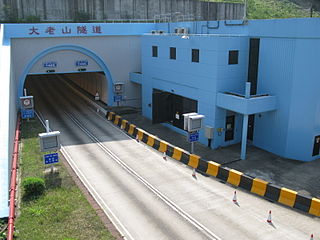
Tate's Cairn Tunnel is a four-lane road tunnel in Hong Kong. Constructed as part of Route 2, it links Diamond Hill, New Kowloon with Siu Lek Yuen, Sha Tin, New Territories East. It opened on 26 June 1991.

Tai Lam Tunnel Tunnel in New Territories, Hong Kong

Tai Lam Tunnel, running along Tsing Long Highway, is part of Route 3 Country Park Section (R3CPS) and is a transport link between the western New Territories in Ting Kau and Yuen Long.

Temple Hill (Hong Kong)

Temple Hill, also known as Tsz Wan Shan, is a hill between New Kowloon and the New Territories, Hong Kong. It peaks at 488 m. Beneath its south side is the residential area of Tsz Wan Shan and Buddhist temples. Sha Tin Pass runs between the hill and Unicorn Ridge.

Hong Kong Strategic Route and Exit Number System Trunk road numbering system in Hong Kong

The Hong Kong Strategic Route and Exit Number System is a system adopted by the Transport Department of the Hong Kong Government to organise the major roads in the territory into routes 1 to 10 for the convenience of drivers. When the system was implemented in 2004, the government promoted it with a major public campaign, including the slogan "Remember the Numbers; Make Driving Easier".

Autotoll

Autotoll Limited (Autotoll) provides Electronic Toll Collection (ETC) service in Hong Kong.

New towns of Hong Kong Newly developed towns in the 20th century

The Hong Kong government started developing new towns in the 1950s to accommodate Hong Kong's booming population. During the first phase of development, the newly developed towns were called "satellite towns", a concept borrowed from the United Kingdom, of which Hong Kong was a colony. Kwun Tong, located in eastern Kowloon, and Tsuen Wan, located in the south-west of the New Territories, were designated as the first satellite towns, when the urban area in Hong Kong was still relatively small, restricted to the central and western parts of Kowloon Peninsula and the northern side of Hong Kong Island. Wah Fu Estate was also built in a remote corner on the southern side of Hong Kong Island, with similar concepts but at a smaller scale.

Tsing Sha Highway

Tsing Sha Highway is a major expressway in Hong Kong, which links the island of Tsing Yi to Sha Tin. The road is part of Route 8, which starts in Sha Tin and terminates in Tung Chung. It was opened in March 2008 and extended in December 2009.

References

  1. "Lion Rock Tunnel: Breakthrough This Afternoon". South China Morning Post. Hong Kong. 20 November 1963. p. 6.
  2. Siu, Phila and Chan, Candy "More tunnel chaos ahead" Archived 25 November 2015 at the Wayback Machine The Standard . 9 March 2012. Retrieved 9 March 2012
  3. https://archives.ln.edu.hk/repositories/2/resources/12
  4. https://commons.ln.edu.hk/lingnan_history_bks/18/
  5. "TransportLion Rock Tunnel" Archived 2 July 2012 at the Wayback Machine
  6. "Traffic Statistics – Lion Rock Tunnel". Transport Department. Hong Kong. 2015.
Preceded by
Waterloo Road
Hong Kong Route 1
HK Route1.svg
Lion Rock Tunnel
Succeeded by
Lion Rock Tunnel Road