Related Research Articles

Burkina Faso is a landlocked country in West Africa with an area of 274,223 km2 (105,878 sq mi), bordered by Mali to the northwest, Niger to the northeast, Benin to the southeast, Togo and Ghana to the south, and Ivory Coast to the southwest. As of 2021, the country had an estimated population of 20,321,378. Previously called Republic of Upper Volta (1958–1984), it was renamed Burkina Faso by President Thomas Sankara. Its citizens are known as Burkinabè, and its capital and largest city is Ouagadougou.
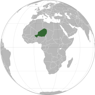
Niger or the Niger, officially the Republic of the Niger, is a landlocked country in West Africa. It is a unitary state bordered by Libya to the northeast, Chad to the east, Nigeria to the south, Benin and Burkina Faso to the southwest, Mali to the west, and Algeria to the northwest. It covers a land area of almost 1,270,000 km2 (490,000 sq mi), making it the largest landlocked country in West Africa and the second largest landlocked nation in Africa behind Chad. Over 80% of its land area lies in the Sahara. Its predominantly Muslim population of about 25 million lives mostly in clusters in the south and west of the country. The capital Niamey is located in Niger's southwest corner.
The history of Burkina Faso includes the history of various kingdoms within the country, such as the Mossi kingdoms, as well as the later French colonisation of the territory and its independence as the Republic of Upper Volta in 1960.
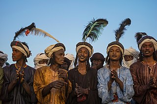
The Fula, Fulani, or Fulɓe people is an ethnic group in Sahara, Sahel and West Africa, widely dispersed across the region. Inhabiting many countries, they live mainly in West Africa and northern parts of Central Africa, South Sudan, Darfur, and regions near the Red Sea coast in Sudan. The approximate number of Fula people is unknown, due to clashing definitions regarding Fula ethnicity. Various estimates put the figure between 25 and 40 million people worldwide.
Tillabéri is one of the seven Regions of Niger; the capital of the Region is Tillabéri. Tillabéri Region was created in 1992, when Niamey Region was split, with Niamey and its immediate hinterland becoming a new capital district enclaved within Tillabéri Region.
The Liptako–Gourma Authority is a regional organization seeking to develop the contiguous areas of Mali, Niger, and Burkina Faso.

Kouroussa is a prefecture located in the Kankan Region of Guinea. The capital is Kouroussa. The prefecture covers an area of 14,050 km.² and has a population of 268,630. With Kouroussa town by far the largest in the Prefecture numbering only 10,000, the vast majority of the Prefecture's population live in small rural communities, making their living from subsistence and small scale cash crop agriculture, as well as small scale trade and mining. The majority of the population are members of the Malinke ethnic group or related Mande speakers. The eastern portion of the prefecture is formed from the Niger River valley, while most of the area characterized by low rolling hills and dry savanna grasslands or scrub-like forest.

The individual member states of the African Union (AU) coordinate foreign policy through this agency, in addition to conducting their own international relations on a state-by-state basis. The AU represents the interests of African peoples at large in intergovernmental organizations (IGO's); for instance, it is a permanent observer at the United Nations' General Assembly.
Téra is a city in the Tillabéri Region, Tera Department of Niger. It is situated 175 km north-west of the capital Niamey, close to the border with Burkina Faso. It is mainly inhabited by Songhai, Fulani, Gourmantche and Buzu ethnic groups. The majority of the population are farmers.

Dori is a town in northeastern Burkina Faso, near the border of Niger. It is located at around 14.03°N 0.03°W. It is the capital of Sahel Region and has a population of 46,512 (2019). The main ethnic group is the Fula (Fulani) but Tuaregs, Songhaiare often present. It is a town known for its herders and popular livestock markets.
Articles related to Burkina Faso include:

Say is a department of the Tillabéri Region in Niger. Its capital city is Say, and includes the towns of Guéladjo, Tamou, and Torodi. It abuts the urban Region of Niamey, and lies across the Niger River to the southwest of the capital. It extends to the Burkina Faso border over 60 km to the west, and the northernmost border with Benin in the south. The Say area is today divided between the riverine valley in the east of the Department, and the more sparsely populated areas to the west, which are intercut with a series of eastward flowing tributaries. The Niger river, a broad shallow channel at Niamey and at Say, passes through a series of gorges and cataracts, called the "W" bend for the shape the river takes, in the south of the Say Department. To the west of these rapids lies what is now the W Regional Park, a sparsely populated area historically plagued by insect borne diseases of both humans and cattle. Now a park and tourist attraction, its history as a "no mans land" has made it a refuge for remaining wild animals, as well as several undisturbed archeological sites. From at least the 16th century CE, the Songhai proper moved south into this area from the north around what is now Tera. The inhabitants at the time were related to the Gourma people, who form most of the population of the northwestern part of the Department today. In the 18th and 19th century, the town of Say was founded by Fulani migrants from the Gao region of modern Mali, with others expanding from what is now northeast Burkina Faso. Between 1810 and the arrival of European writer Heinrich Barth in 1854, Fulani Muslims led by Alfa Mohamed Diobo of Djenné had established the Emirate of Say. The reputation for piety and learning of Mohamed Diobo and his followers helped turn Say from a small river village into a town of 30,000, famed across West Africa as a center of learning.
Téra is a department of the Tillabéri Region in Niger. Its capital lies at the city of Téra. As of 2011, the department had a total population of 579,658 people.
The Kurtey people are a small ethnic group found along the Niger River valley in parts of the West African nations of Niger, Benin, Mali, and Nigeria. They are also found in considerable numbers in Ghana, Togo, Ivory Coast, and Burkina Faso.
Bankilaré is a village and rural commune in Niger. Bankilaré commune, centered on the town of the same name, is in Téra Department, Tillabéri Region, in the northwestern corner of the country. The town lies 60 km north of Departmental capital Téra, and around the same distance from the Burkina Faso border and the Mali border. As of 2012, it had a population of 84,893.
Torodi is a small town and a rural commune in Niger. As of 2012, it had a population of 109,342. As a rural center, Torodi hosts a large weekly market and the seat of local tribal authority (canton). Torodi is in the Say Department of the Tillaberi Region, which surrounds the national capital, Niamey. Say Department, with its capital at the large Niger River town of Say, abuts Niamey to the southwest and across the river to the west. The town of Torodi lies about 60 km due west of the city of Say and 50 km east of the border with Burkina Faso. Torodi itself lies on a tributary of the Niger, the Gourbi river.
The geology of Niger comprises very ancient igneous and metamorphic crystalline basement rocks in the west, more than 2.2 billion years old formed in the late Archean and Proterozoic eons of the Precambrian. The Volta Basin, Air Massif and the Iullemeden Basin began to form in the Neoproterozoic and Paleozoic, along with numerous ring complexes, as the region experienced events such as glaciation and the Pan-African orogeny. Today, Niger has extensive mineral resources due to complex mineralization and laterite weathering including uranium, molybdenum, iron, coal, silver, nickel, cobalt and other resources.
The Niger gold mine collapse occurred on 7 November 2021 when a manually dug well collapsed at the Garin-Liman mining area of Maradi region, Niger. The day of the mine disaster left 18 people dead on the spot, 7 injured and hospitalised, and dozens of miners buried underground waiting to be rescued. However, equipment limitations have slowed the rescue process. On 9 November 2021, two days after the mine disaster, rescuers found more bodies in the collapsed mine. Eventually, the number of people killed in the accident rose to 32. Since the incident took place on the border between Niger and Nigeria, a large number of Nigerians work in the area. According to reports, among the victims, 13 were Nigerians.

The Alliance of Sahel States (AES) is a mutual defense pact created between Mali, Niger, and Burkina Faso on 16 September 2023. The pact was created during the 2023 Nigerien crisis, in which the West African political bloc ECOWAS threatened to intervene militarily to restore civilian rule after a coup in Niger earlier that year.
References
- ↑ J. F. Ade Ajayi, Unesco. International Scientific Committee for the Drafting of a General History of Africa (eds). Africa in the nineteenth century until the 1880s. UNESCO, University of California Press, (1998) ISBN 0-520-06701-0 pp. 269-71, 275, 276
- ↑ The Liptako Fula. Jamtan, Fulfulde encyclopedia. Accessed 2009-05-20.
- ↑ "Daily Herald - Suburban Chicago's Information Source". Daily Herald. Retrieved 2023-06-17.
- ↑ "Burkina Faso president Roch Marc Christian Kabore re-elected". The Times of India. 2020-11-26. ISSN 0971-8257 . Retrieved 2023-06-17.
- ↑ Gold and Base Metal Exploration on the Tialkam Exploration Licence, Liptako Region, Niger, West Africa. Summary of: 'Tialkam Permit, Liptako/Niger - Final Report'.- 20 pp, 14 maps and 19 annexes. GeoServices Int/Barrick/ Anglo-American. Accessed 2009-05-20
- ↑ Martin B.Klien (reviewer) Irwin, Paul. - Liptako Speaks. History from Oral Tradition in Africa. Cahiers d'études africaines, 1984, Volume 24, Issue 96, pp. 511-512