Line 1
Line 1 | ||||||||||||||||||||||||||||||||||||||||||||||||||||||||||||||||||||||||||||||||||||||||||||||||||||||||||||||||||||||||||||||||||||||||||||||||||||||||||||||||||||||||||||||||||||||||||||||||||||||||||||||||||||||||
|---|---|---|---|---|---|---|---|---|---|---|---|---|---|---|---|---|---|---|---|---|---|---|---|---|---|---|---|---|---|---|---|---|---|---|---|---|---|---|---|---|---|---|---|---|---|---|---|---|---|---|---|---|---|---|---|---|---|---|---|---|---|---|---|---|---|---|---|---|---|---|---|---|---|---|---|---|---|---|---|---|---|---|---|---|---|---|---|---|---|---|---|---|---|---|---|---|---|---|---|---|---|---|---|---|---|---|---|---|---|---|---|---|---|---|---|---|---|---|---|---|---|---|---|---|---|---|---|---|---|---|---|---|---|---|---|---|---|---|---|---|---|---|---|---|---|---|---|---|---|---|---|---|---|---|---|---|---|---|---|---|---|---|---|---|---|---|---|---|---|---|---|---|---|---|---|---|---|---|---|---|---|---|---|---|---|---|---|---|---|---|---|---|---|---|---|---|---|---|---|---|---|---|---|---|---|---|---|---|---|---|---|---|---|---|---|---|
| ||||||||||||||||||||||||||||||||||||||||||||||||||||||||||||||||||||||||||||||||||||||||||||||||||||||||||||||||||||||||||||||||||||||||||||||||||||||||||||||||||||||||||||||||||||||||||||||||||||||||||||||||||||||||
Key | ||||||||||||||||||||||||||||||||||||||||||||||||||||||||||||||||||||||||||||||||||||||||||||||||||||||||||||||||||||||||||||||||||||||||||||||||||||||||||||||||||||||||||||||||||||||||||||||||||||||||||||||||||||||||
| ||||||||||||||||||||||||||||||||||||||||||||||||||||||||||||||||||||||||||||||||||||||||||||||||||||||||||||||||||||||||||||||||||||||||||||||||||||||||||||||||||||||||||||||||||||||||||||||||||||||||||||||||||||||||
Line 1 replaces former Line 1B since 4 April 2009. Line 1 does not service though the stations between Erasme/Erasmus and Jacques Brel, which are now serviced by Line 5.
This list of Brussels metro and premetro stations includes all the underground stations in the Brussels metro and premetro network, arranged by line. The premetro refers to sections of the Brussels tramway network which run underground and at metro frequency.
Line 1 | ||||||||||||||||||||||||||||||||||||||||||||||||||||||||||||||||||||||||||||||||||||||||||||||||||||||||||||||||||||||||||||||||||||||||||||||||||||||||||||||||||||||||||||||||||||||||||||||||||||||||||||||||||||||||
|---|---|---|---|---|---|---|---|---|---|---|---|---|---|---|---|---|---|---|---|---|---|---|---|---|---|---|---|---|---|---|---|---|---|---|---|---|---|---|---|---|---|---|---|---|---|---|---|---|---|---|---|---|---|---|---|---|---|---|---|---|---|---|---|---|---|---|---|---|---|---|---|---|---|---|---|---|---|---|---|---|---|---|---|---|---|---|---|---|---|---|---|---|---|---|---|---|---|---|---|---|---|---|---|---|---|---|---|---|---|---|---|---|---|---|---|---|---|---|---|---|---|---|---|---|---|---|---|---|---|---|---|---|---|---|---|---|---|---|---|---|---|---|---|---|---|---|---|---|---|---|---|---|---|---|---|---|---|---|---|---|---|---|---|---|---|---|---|---|---|---|---|---|---|---|---|---|---|---|---|---|---|---|---|---|---|---|---|---|---|---|---|---|---|---|---|---|---|---|---|---|---|---|---|---|---|---|---|---|---|---|---|---|---|---|---|---|
| ||||||||||||||||||||||||||||||||||||||||||||||||||||||||||||||||||||||||||||||||||||||||||||||||||||||||||||||||||||||||||||||||||||||||||||||||||||||||||||||||||||||||||||||||||||||||||||||||||||||||||||||||||||||||
Key | ||||||||||||||||||||||||||||||||||||||||||||||||||||||||||||||||||||||||||||||||||||||||||||||||||||||||||||||||||||||||||||||||||||||||||||||||||||||||||||||||||||||||||||||||||||||||||||||||||||||||||||||||||||||||
| ||||||||||||||||||||||||||||||||||||||||||||||||||||||||||||||||||||||||||||||||||||||||||||||||||||||||||||||||||||||||||||||||||||||||||||||||||||||||||||||||||||||||||||||||||||||||||||||||||||||||||||||||||||||||
Line 1 replaces former Line 1B since 4 April 2009. Line 1 does not service though the stations between Erasme/Erasmus and Jacques Brel, which are now serviced by Line 5.
Line 2 | |||||||||||||||||||||||||||||||||||||||||||||||||||||||||||||||||||||||||||||||||||||||||||||||||||||||||||||||||||||||||||||||||||||||||||||||||||||||||||||||||||||||||||||||||||||||||
|---|---|---|---|---|---|---|---|---|---|---|---|---|---|---|---|---|---|---|---|---|---|---|---|---|---|---|---|---|---|---|---|---|---|---|---|---|---|---|---|---|---|---|---|---|---|---|---|---|---|---|---|---|---|---|---|---|---|---|---|---|---|---|---|---|---|---|---|---|---|---|---|---|---|---|---|---|---|---|---|---|---|---|---|---|---|---|---|---|---|---|---|---|---|---|---|---|---|---|---|---|---|---|---|---|---|---|---|---|---|---|---|---|---|---|---|---|---|---|---|---|---|---|---|---|---|---|---|---|---|---|---|---|---|---|---|---|---|---|---|---|---|---|---|---|---|---|---|---|---|---|---|---|---|---|---|---|---|---|---|---|---|---|---|---|---|---|---|---|---|---|---|---|---|---|---|---|---|---|---|---|---|---|---|---|---|
| |||||||||||||||||||||||||||||||||||||||||||||||||||||||||||||||||||||||||||||||||||||||||||||||||||||||||||||||||||||||||||||||||||||||||||||||||||||||||||||||||||||||||||||||||||||||||
Line 2 was expanded in April 2009 in order to connect the stations Delacroix and Gare de l'Ouest/Weststation. In this way the line now forms a loop between starting and ending in the Simonis/Elisabeth station complex, known as Simonis on its upper level and Elisabeth on its lower level. Most of this line (between Yser/IJzer and Brussels-South railway station) runs under the Brussels small ring.
Line 5 | |||||||||||||||||||||||||||||||||||||||||||||||||||||||||||||||||||||||||||||||||||||||||||||||||||||||||||||||||||||||||||||||||||||||||||||||||||||||||||||||||||||||||||||||||||||||||||||||||||||||||||||||||||||||||||||||||||||||||||||||||||||||||||||||||||||||||||||||||||||||||||||||||||||||||||||||||||||
|---|---|---|---|---|---|---|---|---|---|---|---|---|---|---|---|---|---|---|---|---|---|---|---|---|---|---|---|---|---|---|---|---|---|---|---|---|---|---|---|---|---|---|---|---|---|---|---|---|---|---|---|---|---|---|---|---|---|---|---|---|---|---|---|---|---|---|---|---|---|---|---|---|---|---|---|---|---|---|---|---|---|---|---|---|---|---|---|---|---|---|---|---|---|---|---|---|---|---|---|---|---|---|---|---|---|---|---|---|---|---|---|---|---|---|---|---|---|---|---|---|---|---|---|---|---|---|---|---|---|---|---|---|---|---|---|---|---|---|---|---|---|---|---|---|---|---|---|---|---|---|---|---|---|---|---|---|---|---|---|---|---|---|---|---|---|---|---|---|---|---|---|---|---|---|---|---|---|---|---|---|---|---|---|---|---|---|---|---|---|---|---|---|---|---|---|---|---|---|---|---|---|---|---|---|---|---|---|---|---|---|---|---|---|---|---|---|---|---|---|---|---|---|---|---|---|---|---|---|---|---|---|---|---|---|---|---|---|---|---|---|---|---|---|---|---|---|---|---|---|---|---|---|---|---|---|---|---|---|---|---|---|---|---|---|---|---|---|---|---|---|---|---|---|---|---|---|---|---|---|---|---|---|---|---|---|---|---|---|---|---|---|---|---|---|---|---|---|---|---|---|---|---|---|---|---|---|---|---|---|
| |||||||||||||||||||||||||||||||||||||||||||||||||||||||||||||||||||||||||||||||||||||||||||||||||||||||||||||||||||||||||||||||||||||||||||||||||||||||||||||||||||||||||||||||||||||||||||||||||||||||||||||||||||||||||||||||||||||||||||||||||||||||||||||||||||||||||||||||||||||||||||||||||||||||||||||||||||||
The Line 5 replaces the former Line 1A since 4 April 2009 between Herrmann-Debroux and Beekkant. The section of former Line 1A between Beekkant and King Baudouin is now serviced by Line 6. The section of Line 5 between Beekkant and Erasme/Erasmus was formerly serviced by Line 1B.
Line 6 | |||||||||||||||||||||||||||||||||||||||||||||||||||||||||||||||||||||||||||||||||||||||||||||||||||||||||||||||||||||||||||||||||||||||||||||||||||||||||||||||||||||||||||||||||||||||||||||||||||||||||||||||||||||||||||||||||||
|---|---|---|---|---|---|---|---|---|---|---|---|---|---|---|---|---|---|---|---|---|---|---|---|---|---|---|---|---|---|---|---|---|---|---|---|---|---|---|---|---|---|---|---|---|---|---|---|---|---|---|---|---|---|---|---|---|---|---|---|---|---|---|---|---|---|---|---|---|---|---|---|---|---|---|---|---|---|---|---|---|---|---|---|---|---|---|---|---|---|---|---|---|---|---|---|---|---|---|---|---|---|---|---|---|---|---|---|---|---|---|---|---|---|---|---|---|---|---|---|---|---|---|---|---|---|---|---|---|---|---|---|---|---|---|---|---|---|---|---|---|---|---|---|---|---|---|---|---|---|---|---|---|---|---|---|---|---|---|---|---|---|---|---|---|---|---|---|---|---|---|---|---|---|---|---|---|---|---|---|---|---|---|---|---|---|---|---|---|---|---|---|---|---|---|---|---|---|---|---|---|---|---|---|---|---|---|---|---|---|---|---|---|---|---|---|---|---|---|---|---|---|---|---|---|---|---|---|
| |||||||||||||||||||||||||||||||||||||||||||||||||||||||||||||||||||||||||||||||||||||||||||||||||||||||||||||||||||||||||||||||||||||||||||||||||||||||||||||||||||||||||||||||||||||||||||||||||||||||||||||||||||||||||||||||||||
Line 6 replaces the former Line 1A between Beekkant and King Baudouin since 4 April 2009. It also runs under the Brussels small ring as does Line 2.
Brussels Premetro North-South Axis | ||||||||||||||||||||||||||||||||||||||||||||||||||||||||||||||||||||||||||||||||||||||||||||||||||||||||||||||||||||||||||||||||||||
|---|---|---|---|---|---|---|---|---|---|---|---|---|---|---|---|---|---|---|---|---|---|---|---|---|---|---|---|---|---|---|---|---|---|---|---|---|---|---|---|---|---|---|---|---|---|---|---|---|---|---|---|---|---|---|---|---|---|---|---|---|---|---|---|---|---|---|---|---|---|---|---|---|---|---|---|---|---|---|---|---|---|---|---|---|---|---|---|---|---|---|---|---|---|---|---|---|---|---|---|---|---|---|---|---|---|---|---|---|---|---|---|---|---|---|---|---|---|---|---|---|---|---|---|---|---|---|---|---|---|---|---|---|
| ||||||||||||||||||||||||||||||||||||||||||||||||||||||||||||||||||||||||||||||||||||||||||||||||||||||||||||||||||||||||||||||||||||
The Brussels tram routes 3 and 4 use the North-South Axis and run on surface outside the city centre. The common section offers a high service frequency during daytime hours between Vanderkindere in the municipality of Uccle and the Brussels-North railway station. It shares 4 connections with metro lines and also links two major train stations with access to Thalys and Eurostar trains at Brussels-South railway station.
| # | Name in French | Name in Dutch | Opened | Interchange | Coordinates |
|---|---|---|---|---|---|
| 1 | Gare du Nord | Noordstation | 1976 | NMBS/SNCB | |
| 2 | Rogier | Rogier | 1976 | Line 2, Line 6 | 50°51′13″N4°21′57″E / 50.85361°N 4.36583°E |
| 3 | De Brouckère | De Brouckère | 1976 | Line 1, Line 5 | 50°51′03″N4°21′08″E / 50.85083°N 4.35222°E |
| 4 | Bourse | Beurs | 1976 | None | |
| 5 | Anneessens | Anneessens | 1976 | None | |
| 6 | Lemonnier | Lemonnier | 1976 | None | |
| 7 | Gare du Midi | Zuidstation | 1988 | NMBS/SNCB, Thalys, Eurostar, ICE, Line 2, Line 6 | 50°50′07″N4°20′07″E / 50.835161°N 4.335222°E |
| 8 | Porte de Hal | Hallepoort | 1988 | Line 2, Line 6 | 50°50′1″N4°20′36″E / 50.83361°N 4.34333°E |
| 9 | Parvis de Saint-Gilles | Sint-Gillis Voorplein | 1993 | None | |
| 10 | Horta | Horta | 1993 | None | |
| 11 | Albert | Albert | 1993 | None |
Brussels Premetro Greater Ring | |||||||||||||||||||||||||||||||||||||||||||||||||||||||||||||||
|---|---|---|---|---|---|---|---|---|---|---|---|---|---|---|---|---|---|---|---|---|---|---|---|---|---|---|---|---|---|---|---|---|---|---|---|---|---|---|---|---|---|---|---|---|---|---|---|---|---|---|---|---|---|---|---|---|---|---|---|---|---|---|---|
| |||||||||||||||||||||||||||||||||||||||||||||||||||||||||||||||
The Greater Ring Axis is an underground section under the greater ring of Brussels used by tram routes 7, and 25.
| # | Name in French | Name in Dutch | Opened | Interchange | Coordinates |
|---|---|---|---|---|---|
| 1 | Diamant | Diamant | 1972 | None | |
| 2 | Georges Henri | Georges Henri | 1975 | None | |
| 3 | Montgomery | Montgomery | 1975 | Line 1 | |
| 4 | Boileau | Boileau | 1975 | None |
  Brussels Metro —— Line 1 —— Line 2 —— Line 5 —— Line 6 —— PREMETRO (3 & 4) |
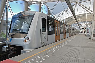
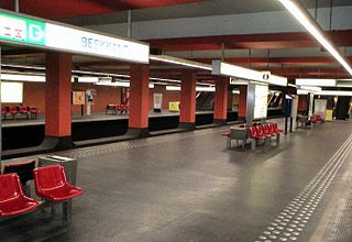
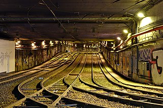
The Brussels Metro is a rapid transit system serving a large part of the Brussels-Capital Region of Belgium. It consists of four conventional metro lines and three premetro lines. The metro-grade lines are M1, M2, M5, and M6 with some shared sections, covering a total of 39.9 kilometres (24.8 mi), with 59 metro-only stations. The premetro network consists of three tram lines that partly travel over underground sections that were intended to be eventually converted into metro lines. Underground stations in the premetro network use the same design as metro stations. A few short underground tramway sections exist, so there is a total of 52.0 kilometres (32.3 mi) of underground metro and tram network. There are a total of 69 metro and premetro stations as of 2011.

The Brussels tramway network is a tram system serving a large part of the Brussels-Capital Region of Belgium. It is the 16th largest tram system in the world by route length, in 2017 providing 149.1 million journeys over routes 140.6 km (87.4 mi) in length. In 2018, it consisted of 18 tram lines. Brussels trams are operated by STIB/MIVB, the local public transport company.

De Brouckère is a rapid transit station located beneath the Place de Brouckère/De Brouckèreplein in central Brussels, Belgium. It consists of both a metro station and a premetro station.

Brussels-Schuman railway station, officially Brussels-Schuman, is a railway station in the City of Brussels, Belgium, serving the European Quarter. It received its name from the area around the Robert Schuman Roundabout, itself named after Robert Schuman.

Sainte-Catherine (French) or Sint-Katelijne (Dutch) is a Brussels Metro station. It is located at the Place Sainte-Catherine/Sint-Katelijneplein, between the Quai aux Briques/Baksteenkaai and the Quai au Bois à Brûler/Brandhoutkaai, in the municipality of the City of Brussels, Belgium. It is also situated near Saint Catherine's Church, which gives the station its name.
The Antwerp Premetro is a network consisting of lines 2, 3, 5, 6, 8, 9, 10 and 15 of the Antwerp Tram system. It is a metre gauge system which runs underground in the city centre and further out on surface lines, which are mostly separated from motor vehicle traffic. The network is operated by De Lijn.

The Premetro is a 7.4-kilometer long (4.6 mi) light rail line that runs along the outskirts of Buenos Aires, connecting with the Buenos Aires Underground line E, at Plaza de los Virreyes station and then to General Savio, with a short branch to Centro Cívico. It opened in 1987 and is operated by Metrovías. Originally, the Premetro was to include many more lines, but shortly after the privatisation of the railways the projects were postponed and never materialised and only "Premetro E2" was built.

Simonis and Elisabeth are two interconnected stations on the Brussels Metro serving line 2 and line 6 on two different levels. Additionally Simonis is a railway station operated by the National Railway Company of Belgium (NMBS/SNCB) and a tram stop.
Beekkant is a Brussels Metro station located in the municipality of Molenbeek-Saint-Jean, in the western part of Brussels, Belgium. It opened on 8 May 1981 as part of the Sainte-Catherine/Sint-Katelijne–Beekkant extension of former line 1, and was for a year, until 6 October 1982, the western terminus of the metro. Following the reorganisation of the Brussels Metro on 4 April 2009, it is served by lines 1, 2, 5 and 6.
Brussels-West Station is a multimodal transport hub located in the municipality of Molenbeek-Saint-Jean, in the western part of Brussels, Belgium. The metro station opened on 6 October 1982 as part of the Beekkant–Saint Guidon/Sint-Guido extension of former line 1B. Following the reorganisation of the Brussels Metro on 4 April 2009, it is served by lines 1, 2, 5 and 6.

Porte de Hal or Hallepoort (Dutch) is a rapid transit station in Brussels, Belgium, consisting of both a metro station and a premetro station. The metro station opened on 2 October 1988 and the premetro station opened on 3 December 1993.

Rogier is a rapid transit station in Brussels, Belgium, consisting of both a metro station and a premetro station. It is located under the Small Ring at the Place Charles Rogier/Karel Rogierplein in the municipality of the Saint-Josse-ten-Noode, north of the City of Brussels.

The tram route 51 in Brussels, Belgium is a tram route operated by the STIB/MIVB, which connects the Heysel metro station in the City of Brussels to the Van Haelen stop in the municipality of Uccle. The route runs North-South, crossing the municipalities of the City of Brussels, Jette, Molenbeek-Saint-Jean, the City of Brussels again, Saint-Gilles, Forest and Uccle. Currently, service is interrupted between Gare du Midi/Zuidstation and Altitude Cent/Hoogt Hondred due to construction work at Albert station.
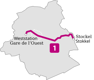
Line 1 is a line on the Brussels Metro in Belgium operated by STIB/MIVB. It has existed in its current form since 4 April 2009, when the former line 1B, which ran between Stockel/Stokkel and Erasme/Erasmus, was shortened to Gare de l'Ouest/Weststation. The section between West station and Erasme is now served by line 5. The line serves 21 metro stations, and has a common section with line 5 between West station and Mérode station, and with lines 2 and 6 between West station and Beekkant. At Arts-Loi/Kunst-Wet the line also connects with lines 2 and 6. Railway connections are possible at Brussels-Central railway station, Schuman station, Mérode and West stations. The line crosses the municipalities of Molenbeek-Saint-Jean, Koekelberg, City of Brussels, Etterbeek, Woluwe-Saint-Pierre and Woluwe-Saint-Lambert.

Line 2 on the Brussels Metro is a rapid transit line in Brussels, Belgium operated by STIB/MIVB. It exists in its current form since April 4, 2009, when the section between Delacroix metro station and Gare de l'Ouest/Weststation was opened, which allowed to close the loop from and to Simonis/Elisabeth. The configuration of the Simonis/Elisabeth metro station though does not allow trains on the line 2 to be able to perform the loop several consecutive times in the same direction, i.e. a train running clockwise from Elisabeth will have to run counterclockwise from Simonis. The two termini of line 2 have thus received different names: originally Simonis (Elisabeth) and Simonis , changed in November 2013 to Elisabeth and Simonis. Between the Yser/IJzer metro station and the Porte de Hal/Hallepoort station, the line runs under the small ring road of Brussels, which is itself built on the former Second walls of Brussels.

Line 5 on the Brussels Metro is a rapid transit line operated by STIB/MIVB, which connects Herrmann-Debroux at the south-east of Brussels, Belgium to Erasme/Erasmus at the south-west via the city center. It exists in its current form since April 4, 2009, when the section of former line 1A between Beekkant and King Baudouin was replaced by the section of former line 1B between Beekkant and Erasme. Starting from Herrmann-Debroux, the line crosses the municipalities of Auderghem, Etterbeek, City of Brussels, Molenbeek-Saint-Jean, Koekelberg and Anderlecht. It serves 28 metro stations and has a common section with line 1 between Gare de l'Ouest/Weststation and Mérode station, and with lines 2 and 6 between West station and Beekkant. At Arts-Loi/Kunst-Wet the line also connects with lines 2 and 6. Railway connections are possible at Brussels-Central railway station, Schuman station, Mérode and West station.
Line 6 of the Brussels Metro is a rapid transit line operated by STIB/MIVB, which connects King Baudouin metro station at the north-west of Brussels, Belgium to Simonis metro station at the north-west of the city center, then performing a counterclockwise loop around the center up to Simonis again. During this loop, the line runs under the small ring road of Brussels from Porte de Hal/Hallepoort station to Yser/IJzer metro station. It serves 25 metro stations and has 26 stops, metros on that line stopping twice at Simonis. It exists in its current form since 4 April 2009, when it replaced the former Line 1A between King Baudouin and Beekkant. The loop Simonis-Simonis is also served by line 2. The line has also a common section with lines 1 and line 5 between Gare de l'Ouest/Weststation and Beekkant. A connection with those lines is also possible at Arts-Loi/Kunst-Wet. Starting from King Baudouin, the line crosses the municipalities of the City of Brussels, Jette, Koekelberg, Molenbeek-Saint-Jean, Anderlecht and Saint-Gilles.
The North–South Axis is a tram tunnel in Brussels, Belgium, which crosses the city centre from North to South between Brussels-North railway station and Albert premetro station.
Lemonnier premetro station is a premetro station in central Brussels, Belgium, located near the crossroads between the Boulevard Maurice Lemonnier/Maurice Lemonnierlaan and the Small Ring.

The Brussels premetro and tramline 7 connects the Vanderkindere stop in Uccle with the Heizel/Heysel stop in Laeken, where connecting services of tram 51, metro 6, bus 84 and bus 88 depart. The colour of the signage for this line is bright yellow.
