Related Research Articles
The Northeastern coastal forests are a temperate broadleaf and mixed forests ecoregion of the northeast and middle Atlantic region of the United States. The ecoregion covers an area of 34,630 sq miles (89,691 km2) encompassing the Piedmont and coastal plain of seven states, extending from coastal southwestern Maine, southeastern New Hampshire, eastern Massachusetts, and Rhode Island, southward through Connecticut, New York State, New Jersey, southeast Pennsylvania, Delaware and Maryland.

The Chavez Ravine Arboretum, in Elysian Park, just north of Dodger Stadium, at 1025 Elysian Park Dr, Los Angeles, California, contains more than 100 varieties of trees from around the world, including what are believed to be the oldest and largest Cape Chestnut, Kauri, and Tipu trees in the United States. Admission to the arboretum is free.
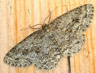
The engrailed and small engrailed are moths of the family Geometridae found from the British Isles through central and eastern Europe to the Russian Far East and Kazakhstan. The western Mediterranean and Asia Minor and the Caucasus represent the southern limit of the distribution. In the north, the distribution area ends at the Arctic Circle. It also occurs in North America. Debate exists as to whether they make up one species, or whether E. crepuscularia actually refers only to the small engrailed, with the engrailed proper being separable as E. bistortata.

The Donald E. Davis Arboretum, in Auburn, Alabama, United States, is a public native plants museum, and botanical arboretum with educational facilities, event spaces, and a conservation program. Its grounds, covering 13.5 acres of Auburn University's campus, include cataloged living collections of associated tree and plant communities representative of Alabama's ecosystems, among which is mixed oak forest, carnivorous bog, and longleaf pine savanna. The living collections include more than 1,000 plant types, including 500 different plant species, with over 3,000 cataloged specimens. The Arboretum contains over a mile (2 km) of interwoven walking trails that meander through various southeastern biotopes.

Nichols Arboretum, locally known as the Arb, is an arboretum operated by the Matthaei Botanical Gardens and Nichols Arboretum (MBGNA) at the University of Michigan. Located on the eastern edge of its Central Campus at 1610 Washington Heights in Ann Arbor, Michigan, the Arboretum is a mosaic of University and City properties operated as one unit. The arboretum is open daily from sunrise to sunset with no charge for admission. The Huron River separates a northern section of the arboretum's floodplain woods; the railroad marks the northern border.

The Appalachian mixed mesophytic forests is an ecoregion of the temperate broadleaf and mixed forests biome, as defined by the World Wildlife Fund. It consists of mesophytic plants west of the Appalachian Mountains in the Southeastern United States.

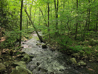
The Appalachian–Blue Ridge forests are an ecoregion in the Temperate broadleaf and mixed forests Biome, in the Eastern United States. The ecoregion is located in the central and southern Appalachian Mountains, including the Ridge-and-Valley Appalachians and the Blue Ridge Mountains. It covers an area of about 61,500 square miles (159,000 km2) in: northeast Alabama and Georgia, northwest South Carolina, eastern Tennessee, western North Carolina, Virginia, Maryland, and central West Virginia and Pennsylvania; and small extensions into Kentucky, New Jersey, and New York.

The New England-Acadian forests are a temperate broadleaf and mixed forest ecoregion in North America that includes a variety of habitats on the hills, mountains and plateaus of New England and New York State in the Northeastern United States, and Quebec and the Maritime Provinces of Eastern Canada.

Weeping trees are trees characterized by soft, limp twigs. This characterization may lead to a bent crown and pendulous branches that can cascade to the ground. While weepyness occurs in nature, most weeping trees are cultivars. Because of their shape, weeping trees are popular in landscaping; generally they need a lot of space and are solitary so that their effect is more pronounced. There are over a hundred different types of weeping trees. Some trees, such as the cherry, have a variety of weeping cultivars. There are currently around 550 weeping cultivars in 75 different genera, although many have now disappeared from cultivation.

The Gulf of St. Lawrence lowland forests are a temperate broadleaf and mixed forest ecoregion of Eastern Canada, as defined by the World Wildlife Fund (WWF) categorization system.

The Ecological regions of Quebec are regions with specific types of vegetation and climates as defined by the Quebec Ministry of Forests, Wildlife and Parks. Given the size of this huge province, there is wide variation from the temperate deciduous forests of the southwest to the arctic tundra of the extreme north.
References
- ↑ Sherman-Broyles, Susan L. (1997). "Ulmus glabra". In Flora of North America Editorial Committee (ed.). Flora of North America North of Mexico (FNA). Vol. 3. New York and Oxford: Oxford University Press – via eFloras.org, Missouri Botanical Garden, St. Louis, MO & Harvard University Herbaria, Cambridge, MA.
- ↑ "Ulmus glabra". County-level distribution map from the North American Plant Atlas (NAPA). Biota of North America Program (BONAP). 2014.
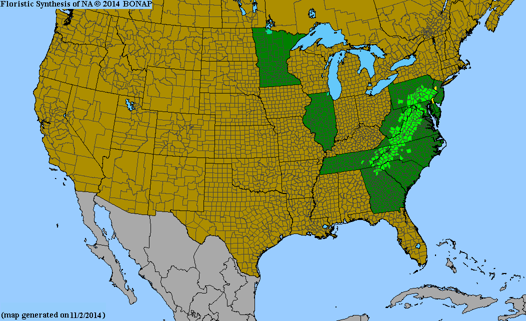
- ↑ "Pinus pungens". County-level distribution map from the North American Plant Atlas (NAPA). Biota of North America Program (BONAP). 2014.
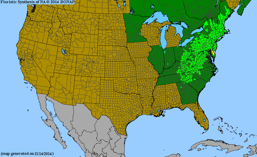
- ↑ "Pinus rigida". County-level distribution map from the North American Plant Atlas (NAPA). Biota of North America Program (BONAP). 2014.