List of Ramsar sites in Scotland

Last updated

This list includes all Ramsar sites in Scotland. Ramsar sites are internationally recognised wetland sites, protected under the terms of the Ramsar Convention, which was developed and adopted by participating nations at a meeting in Ramsar, Iran, on 2 February 1971. At the end of 2010, 160 states were contracting parties to the convention, and the worldwide total of sites was 1,920. The United Kingdom was one of 18 original signatories to the convention, and has since designated 168 Ramsar sites. 51 of these sites are within Scotland, including one site, the Upper Solway Flats and Marshes, which covers parts of both Scotland and England in the Solway Firth. The total area of all Ramsar sites in Scotland is approximately 313,500 hectares (775,000 acres). [1] All of Scotland's Ramsar sites form part of the European Natura 2000 network as either Special Protection Areas or Special Areas of Conservation, and many sites are further protected as Sites of Special Scientific Interest under UK legislation.

Contents

Map all coordinates using: OpenStreetMap

List of Ramsar sites in Scotland

Name [1] Council area DesignatedArea (hectares)CoordinatesSite codeImage
Bridgend Flats, Islay Argyll and Bute 1988-07-14331 55°46′0″N6°16′0″W / 55.76667°N 6.26667°W / 55.76667; -6.26667 (Bridgend Flats) UK13001
Cairngorm Lochs Aberdeenshire / Highland / Moray 1981-07-24173 57°4′0″N3°47′0″W / 57.06667°N 3.78333°W / 57.06667; -3.78333 (Cairngorm Lochs) UK13002 Loch Avon - geograph.org.uk - 886066.jpg
Caithness and Sutherland Peatlands Highland 1999-02-02143,503 58°20′0″N3°56′0″W / 58.33333°N 3.93333°W / 58.33333; -3.93333 (Caithness and Sutherland Peatlands) UK13003 Sutherland Flow Country.jpg
Caithness Lochs Highland 1998-02-021,379 58°29′0″N3°20′0″W / 58.48333°N 3.33333°W / 58.48333; -3.33333 (Caithness Lochs) UK13004 Loch Watten.jpg
Cameron Reservoir Fife 1994-03-1469 56°18′0″N2°51′0″W / 56.30000°N 2.85000°W / 56.30000; -2.85000 (Cameron Reservoir) UK13005 Cameron Reservoir, East dam - geograph.org.uk - 152846.jpg
Castle Loch, Lochmaben Dumfries and Galloway 1996-03-15108 55°7′0″N3°26′0″W / 55.11667°N 3.43333°W / 55.11667; -3.43333 (Castle Loch) UK13006 Castle Loch - geograph.org.uk - 812536.jpg
Claish Moss Highland 1981-07-24568 56°44′0″N5°44′0″W / 56.73333°N 5.73333°W / 56.73333; -5.73333 (Claish Moss) UK13007
Coll Argyll and Bute 1995-03-312,209 56°39′0″N6°30′0″W / 56.65000°N 6.50000°W / 56.65000; -6.50000 (Coll) UK13008 Traigh Feall - Isle of Coll.jpg
Cromarty Firth Highland 1999-07-223,747 57°41′0″N4°12′0″W / 57.68333°N 4.20000°W / 57.68333; -4.20000 (Cromarty Firth) UK13009 Cromarty Firth entrance.jpg
Din Moss - Hoselaw Loch Scottish Borders 1988-07-1451 55°35′0″N2°18′0″W / 55.58333°N 2.30000°W / 55.58333; -2.30000 (Din Moss - Hoselaw Loch) UK13010
Dornoch Firth and Loch Fleet Highland 1997-03-247,837 57°51′0″N4°2′0″W / 57.85000°N 4.03333°W / 57.85000; -4.03333 (Dornoch Firth andLoch Fleet) UK13011 Shoreline looking across Dornoch Firth - geograph.org.uk - 687442.jpg
East Sanday Coast Orkney 1997-08-111,515 59°16′0″N2°34′0″W / 59.26667°N 2.56667°W / 59.26667; -2.56667 (East Sanday Coast) UK13013
Eilean na Muice Duibhe (Duich Moss), Islay Argyll and Bute 1988-07-14576 55°43′0″N6°15′0″W / 55.71667°N 6.25000°W / 55.71667; -6.25000 (Eilean na Muice Duibhe) UK13014
Fala Flow Midlothian 1990-04-25318 55°49′0″N2°54′0″W / 55.81667°N 2.90000°W / 55.81667; -2.90000 (Fala Flow) UK13015
Firth of Forth Clackmannanshire / East Lothian / Edinburgh / Falkirk / Fife /Stirling / West Lothian 2001-10-306,314 56°1′0″N2°53′0″W / 56.01667°N 2.88333°W / 56.01667; -2.88333 (Firth of Forth) UK13017 The Forth bridges from the air (geograph 5835049).jpg
Firth of Tay & Eden Estuary Angus / Dundee / Fife / Perth and Kinross 2000-07-286,918 56°24′0″N3°5′0″W / 56.40000°N 3.08333°W / 56.40000; -3.08333 (Firth of Tay and Eden Estuary) UK13018 Black Earnside looking west towards Mugdrun Island - geograph.org.uk - 20458.jpg
Gladhouse Reservoir Midlothian 1988-07-14186 55°47′0″N3°6′0″W / 55.78333°N 3.10000°W / 55.78333; -3.10000 (Gladhouse Reservoir) UK13021 A tranquil day at Gladhouse Reservoir - geograph.org.uk - 1713019.jpg
Greenlaw Moor Scottish Borders 1996-03-15248 55°44′0″N2°27′0″W / 55.73333°N 2.45000°W / 55.73333; -2.45000 (Greenlaw Moor) UK13022
Gruinart Flats, Islay Argyll and Bute 1988-07-143,261 55°51′0″N6°20′0″W / 55.85000°N 6.33333°W / 55.85000; -6.33333 (Gruinart Flats) UK13023 Gruinartflatssedge.jpg
Inner Clyde Estuary East Dunbartonshire / Inverclyde / Renfrewshire / West Dunbartonshire 2000-09-051,825 55°57′0″N4°38′0″W / 55.95000°N 4.63333°W / 55.95000; -4.63333 (Inner Clyde Estuary) UK13024
Inner Moray Firth Highland 1999-07-222,339 56°50′0″N4°21′0″W / 56.83333°N 4.35000°W / 56.83333; -4.35000 (Inner Moray Firth) UK13025 Moray Firth from Findhorn Beach - geograph.org.uk - 602485.jpg
Kintyre Goose Roosts Argyll and Bute 1998-10-28312 55°31′0″N5°37′0″W / 55.51667°N 5.61667°W / 55.51667; -5.61667 (Kintyre Goose Roosts) UK13027 Western shore of Lussa Loch. - geograph.org.uk - 105354.jpg
Lewis Peatlands Na h-Eileanan Siar 2000-12-2258,984 58°15′0″N6°35′0″W / 58.25000°N 6.58333°W / 58.25000; -6.58333 (Lewis Peatlands) UK13028
Loch an Duin Na h-Eileanan Siar 1990-04-252,621 57°38′0″N7°9′0″W / 57.63333°N 7.15000°W / 57.63333; -7.15000 (Loch an Dùin) UK13029
Loch Eye Highland 1986-10-01205 57°47′0″N3°58′0″W / 57.78333°N 3.96667°W / 57.78333; -3.96667 (Loch Eye) UK13031 Boat at Loch Eye - geograph.org.uk - 907077.jpg
Loch Ken and River Dee Marshes Dumfries and Galloway 1992-08-31769 54°59′0″N4°1′0″W / 54.98333°N 4.01667°W / 54.98333; -4.01667 (Loch Ken and River Dee Marshes) UK13032 Loch Ken.jpg
Loch Leven Perth and Kinross 1976-01-051,612 56°12′0″N3°23′0″W / 56.20000°N 3.38333°W / 56.20000; -3.38333 (Loch Leven) UK13033 Loch Leven Kinross.jpg
Loch Lomond Stirling / West Dunbartonshire 1976-01-05237 56°4′0″N4°30′0″W / 56.06667°N 4.50000°W / 56.06667; -4.50000 (Loch Lomond) UK13034 LochLomond(wfmillar)Jan2000.jpg
Loch Maree Highland 1994-09-193,174 57°41′0″N5°28′0″W / 57.68333°N 5.46667°W / 57.68333; -5.46667 (Loch Maree) UK13035 Slioch from Loch Maree.jpg
Loch of Inch and Torrs Warren Dumfries and Galloway 1999-02-022,111 54°50′0″N4°52′0″W / 54.83333°N 4.86667°W / 54.83333; -4.86667 (Loch of Inch and Torrs Warren) UK13037
Loch of Kinnordy Angus 1994-03-2985 56°40′0″N3°3′0″W / 56.66667°N 3.05000°W / 56.66667; -3.05000 (Loch of Kinnordy) UK13038 Sunset over Loch of Kinnordy - geograph.org.uk - 1745789.jpg
Loch of Lintrathen Angus 1981-07-24217 56°41′0″N3°11′0″W / 56.68333°N 3.18333°W / 56.68333; -3.18333 (Loch of Lintrathen) UK13039
Loch of Skene Aberdeenshire 1986-10-01121 57°9′0″N2°21′0″W / 57.15000°N 2.35000°W / 57.15000; -2.35000 (Loch of Skene) UK13040 Loch of Skene - geograph.org.uk - 259667.jpg
Loch of Strathbeg Aberdeenshire 1995-11-27616 57°37′0″N1°53′0″W / 57.61667°N 1.88333°W / 57.61667; -1.88333 (Loch of Strathbeg) UK13041 Lochofstrathbeg2.jpg
Loch Ruthven Highland 1996-08-16201 57°20′0″N4°17′0″W / 57.33333°N 4.28333°W / 57.33333; -4.28333 (Loch Ruthven) UK13042 Loch Ruthven from N.E., Tullich - geograph.org.uk - 908082.jpg
Loch Spynie Moray 1992-08-3194 57°41′0″N3°17′0″W / 57.68333°N 3.28333°W / 57.68333; -3.28333 (Loch Spynie) UK13043 Bird Watchers Hut on Loch Spynie. - geograph.org.uk - 175832.jpg
Montrose Basin Angus 1995-02-03985 56°43′0″N2°30′0″W / 56.71667°N 2.50000°W / 56.71667; -2.50000 (Montrose Basin) UK13046 Montrose Basin.jpg
Moray and Nairn Coast Highland / Moray 1997-02-022,412 57°39′0″N3°44′0″W / 57.65000°N 3.73333°W / 57.65000; -3.73333 (Moray and Nairn Coast) UK13048
Muir of Dinnet Aberdeenshire 1999-07-22158 57°5′0″N2°55′0″W / 57.08333°N 2.91667°W / 57.08333; -2.91667 (Muir of Dinnet) UK13049 Loch Kinord - geograph.org.uk - 7242.jpg
North Uist Machair and Islands Na h-Eileanan Siar 1999-07-22 (extended 2000-11-03)4,705 57°32′0″N7°23′0″W / 57.53333°N 7.38333°W / 57.53333; -7.38333 (North Uist Machair and Islands) UK13050
Rannoch Moor Perth and Kinross 1976-01-051,519 56°39′0″N4°36′0″W / 56.65000°N 4.60000°W / 56.65000; -4.60000 (Rannoch Moor) UK13051 Rannoch Moor.jpg
Rinns of Islay Argyll and Bute 1990-04-253,571 55°51′0″N6°23′0″W / 55.85000°N 6.38333°W / 55.85000; -6.38333 (Rinns of Islay) UK13052 Beinn Tart A' Mhill summit.jpg
River SpeyInsh Marshes Highland 1997-02-021,159 57°5′0″N4°0′0″W / 57.08333°N 4.00000°W / 57.08333; -4.00000 (River Spey - Insh Marshes) UK13053 River Spey.jpg
Ronas HillNorth Roe and Tingon Shetland 1997-08-115,470 60°33′0″N1°25′0″W / 60.55000°N 1.41667°W / 60.55000; -1.41667 (Ronas Hill – North Roe and Tingon) UK13054 Ayre at North Roe (geograph 2076946).jpg
Silver Flowe Dumfries and Galloway 1981-07-24620 55°7′0″N4°24′0″W / 55.11667°N 4.40000°W / 55.11667; -4.40000 (Silver Flowe) UK13055 Silver Flowe from Dungeon Hill.jpg
Sléibhtean agus Cladach Thiriodh (Tiree Wetlands and Coast) Argyll and Bute 2001-11-161,939 56°30′0″N6°52′0″W / 56.50000°N 6.86667°W / 56.50000; -6.86667 (Sléibhtean agus Cladach Thiriodh) UK13056
South Tayside Goose Roosts Perth and Kinross 1993-04-22331 56°16′0″N3°50′0″W / 56.26667°N 3.83333°W / 56.26667; -3.83333 (South Tayside Goose Roosts) UK13057
South Uist Machair and Lochs Na h-Eileanan Siar 1976-01-055,019 57°19′0″N7°20′0″W / 57.31667°N 7.33333°W / 57.31667; -7.33333 (South Uist Machair and Lochs) UK13058
Upper Solway Flats and Marshes Dumfries and Galloway / Cumbria 1986-10-0143,637 54°54′0″N3°25′0″W / 54.90000°N 3.41667°W / 54.90000; -3.41667 (Upper Solway Flats and Marshes) UK11079
Westwater Scottish Borders 1995-11-2750 55°45′0″N3°24′0″W / 55.75000°N 3.40000°W / 55.75000; -3.40000 (Westwater Reservoir) UK13060 The West Water Reservoir dam - geograph.org.uk - 1012032.jpg
Ythan Estuary and Meikle Loch Aberdeenshire 1998-03-30314 57°20′0″N1°57′0″W / 57.33333°N 1.95000°W / 57.33333; -1.95000 (Ythan Estuary and Meikle Loch) UK13061 Mid to upper reach of Ythan Estuary looking west, Aberdeenshire.jpg

See also

Related Research Articles

A special protection area (SPA) is a designation under the European Union Directive on the Conservation of Wild Birds. Under the Directive, Member States of the European Union (EU) have a duty to safeguard the habitats of migratory birds and certain particularly threatened birds. Together with special areas of conservation (SACs), the SPAs form a network of protected sites across the EU, called Natura 2000. Each SPA has an EU code – for example the North Norfolk Coast SPA has the code UK9009031.

<span class="mw-page-title-main">Protected areas of the United Kingdom</span> Designated area for protection in the United Kingdom

Protected areas of the United Kingdom are areas in the United Kingdom which need and /or receive protection because of their environmental, historical or cultural value to the nation. Methods and aims of protection vary depending on the nature and importance of the resource. Protection operates at local, regional, national and international levels, and may be backed by legislation and international treaty, or less formally by planning policy.

<span class="mw-page-title-main">Caerlaverock National Nature Reserve</span>

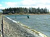
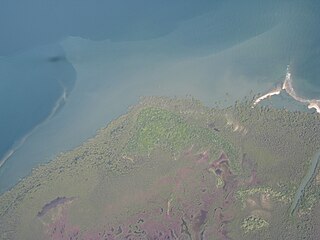
Caerlaverock is a national nature reserve (NNR) covering parts of the mudflats and shoreline of the Solway Firth about 10 km south of Dumfries, in Dumfries and Galloway, Scotland. It lies between the River Nith and the Lochar Water, and consists of a variety of wetland habitats including bare mud and sand, merse and marshes, and is fringed by neutral grassland on the landward side. A nature reserve was designated in 1957 at the instigation of the Duke of Norfolk. The NNR covers an area of 82 square kilometres (32 sq mi) and is an internationally important wintering site for waterfowl and wading birds.

<span class="mw-page-title-main">Insh Marshes</span>

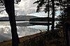
Insh Marshes are an area of floodplain of the River Spey between Kingussie and Kincraig in Badenoch and Strathspey, Highland, Scotland. The marshes are said to be one of the most important wetlands in Europe. They lie at altitude of approximately 240 to 220 m above sea level, and form one of the largest areas of floodplain mire and fen vegetation in Scotland.

<span class="mw-page-title-main">Important Bird Area</span> Area recognized as a habitat for bird population conservation

An Important Bird and Biodiversity Area (IBA) is an area identified using an internationally agreed set of criteria as being globally important for the conservation of bird populations.

<span class="mw-page-title-main">North Roe</span> Human settlement in Scotland

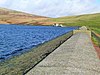
North Roe is a village, and protected area at the northern tip in the large Northmavine peninsula of the Mainland of Shetland, Scotland. It is a small village, with a school with less than a dozen pupils in 2011. The moorland plateau to the south-west of the settlement is part of the Ronas Hill-North Roe and Tingon internationally recognised wetland site, protected under the terms of the Ramsar Convention on Wetlands, and also a Special Protection Area under the Birds Directive. The village is served by the A970 road which runs the length of the Shetland mainland from south to north and is a single-carriageway for the final nine miles.

<span class="mw-page-title-main">Protected areas of Poland</span>

Protected areas of Poland include the following categories, as defined by the Act on Protection of Nature of 16 April 2004, by the Polish Parliament:

<span class="mw-page-title-main">Moreton Bay Marine Park</span> Protected area in Queensland, Australia

The Moreton Bay Marine Park was established in 1993 to protect ecologically significant habitats in Moreton Bay. The marine park extends from Caloundra south to the southern tip of South Stradbroke Island. The marine park's border extends up to the highest tidal mark and covers a total of 3,400 km2.

The Port Phillip Bay and Bellarine Peninsula Ramsar Site is one of the Australian sites listed under the Ramsar Convention as a wetland of international importance. It was designated on 15 December 1982, and is listed as Ramsar Site No.266. Much of the site is also part of either the Swan Bay and Port Phillip Bay Islands Important Bird Area or the Werribee and Avalon Important Bird Area, identified as such by BirdLife International because of their importance for wetland and waterbirds as well as for orange-bellied parrots. It comprises some six disjunct, largely coastal, areas of land, totalling 229 km2, along the western shore of Port Phillip and on the Bellarine Peninsula, in the state of Victoria. Wetland types protected include shallow marine waters, estuaries, freshwater lakes, seasonal swamps, intertidal mudflats and seagrass beds.

The Forrestdale and Thomsons Lakes Ramsar Site comprises two separate nature reserves, totalling 754 ha in area, protecting two shallow fresh to brackish, seasonal lakes in a suburban and agricultural landscape in south-western Western Australia. It lies in the Swan Coastal Plain bioregion and is used mainly for birdwatching and walking. The site is recognised as being of international importance under the Ramsar Convention on Wetlands, under which it was designated Ramsar Site 481 on 7 June 1990.

<span class="mw-page-title-main">Protected areas of Scotland</span> Designated area for protection in Scotland

Many parts of Scotland are protected in accordance with a number of national and international designations because of their environmental, historical or cultural value. Protected areas can be divided according to the type of resource which each seeks to protect. NatureScot has various roles in the delivery of many environmental designations in Scotland, i.e. those aimed at protecting flora and fauna, scenic qualities and geological features. Historic Environment Scotland is responsible for designations that protect sites of historic and cultural importance. Some international designations, such as World Heritage Sites, can cover both categories of site.

<span class="mw-page-title-main">Caithness Lochs</span> Series of lochs in northern Scotland

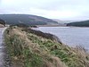
Caithness Lochs is a protected wetland area in the historic county of Caithness in the far north of Scotland. With a total area of 1,379 hectares, it covers six freshwater lochs and a complex area of fen and swamp, and has been protected as a Ramsar Site since 1998.

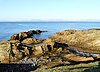
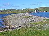
The East Sanday Coast is a protected wetland area on and around the island of Sanday, the third-largest of the Orkney islands off the north coast of Scotland. With a total protected area of 1,515 hectares, the 55 kilometre stretch of coast includes rocky and sandy sections, sand dunes, machair habitats, intertidal flats, and saltmarsh. It has been protected as a Ramsar Site since 1997.

<span class="mw-page-title-main">South Tayside Goose Roosts</span> Series of lochs in central Scotland

South Tayside Goose Roosts is a composite wetland site to the west of Perth in central Scotland, covering a total of 331 hectares, which has been protected as a Ramsar Site since 1993. Incorporating three disconnected sections, separated by several kilometres, the site contains seven freshwater lochs along with other wetland habitats, including one of the largest raised bogs in the region.

References

  1. 1 2 "Ramsar List" (PDF). Ramsar.org. Retrieved 31 March 2013.