List of West Virginia wildlife management areas

Last updated

This is a list of wildlife management areas in West Virginia.

Contents

West Virginia wildlife management areas

West Virginia Wildlife Management Areas

Wildlife Management Area

County

Area

Accommodations [1]

Lakes

Shooting
Ranges [2]

Acres

Hectares

Cabins

Camping

Allegheny Mineral 5,8842,381
HometownWVPark-square.jpg Amherst-Plymouth Putnam 7,0612,857
Anawalt Lake-square.jpg Anawalt Lake McDowell 2,097849 Yes check.svg
Bear Rock Lakes WMA - Bear Lake-square.jpg Bear Rock Lakes Ohio 24298 Yes check.svg
Becky Creek Randolph 1,930781
Beech Fork State Park Lake-square.jpg Beech Fork Lake Cabell
Wayne
7,5313,048 Yes check.svg Yes check.svg
Berwind Lake WMA-square.jpg Berwind Lake McDowell 93388 Yes check.svg
Beury Mountain Fayette 9,232 [3] [4] 3,736
Big Ditch WMA - Big Ditch Lake-square.jpg Big Ditch Webster 388157 Yes check.svg
Big Ugly Lincoln 5,3002,145 Yes check.svg
Bluestone Wildlife Management Area - Sign-square.jpg Bluestone Lake Summers
Mercer
Monroe
18,0197,292330 Yes check.svg Yes check.svg
Burches Run WMA - Sign-square.jpg Burches Run Marshall 5522
Falls Mill (Burnsville Lake)-square.jpg Burnsville Lake Braxton 12,5795,091 Yes check.svg
Castleman Run Lake WMA-square.jpg Castleman Run Lake Brooke
Ohio
486197 Yes check.svg
Cecil H Underwood WMA - Sign-square.jpg Cecil H. Underwood Marshall 2,115856
Center Branch Wildlife Management Area - Wetlands in Winter-square.jpg Center Branch Harrison 974394
Cheat Canyon Preston 3,836 [5] 1,552
Chief Cornstalk Mason 11,7724,764 Yes check.svg Yes check.svg
Conaway Run Lake Tyler 630255 Yes check.svg Yes check.svg
Cross Creek Brooke 2,080842 Yes check.svg
Dents Run Marion 1,226496 Yes check.svg
Dunkard Fork WMA - Dunkard Fork Lake-square.jpg Dunkard Fork Marshall 470190 Yes check.svg
East Lynn Lake - View from Dam-square.jpg East Lynn Lake Wayne 22,9289,279 Yes check.svg
Edwards Run at Edwards Run WMA.jpg Edwards Run Hampshire 397153 Yes check.svg
Elk Creek Logan
Mingo
6,0042,430
Elk River Braxton 18,2257,375 Yes check.svg
Fairfax Pond-Rehe Preston 638258
Fort Mill Ridge Civil War Trenches Romney WV 2008 10 30 09-square.JPG Fort Mill Ridge Hampshire 21788
Frozen Camp Jackson 2,7351,107 Yes check.svg Yes check.svg
Green Bottom WMA - Sign-square.jpg Green Bottom Cabell
Mason
1,096444
Handley Pocahontas 784317
Hilbert Lincoln 289117
Hillcrest Hancock 2,212895 Yes check.svg
Horse Creek Wyoming 4819
Hughes River Ritchie
Wirt
10,0004,047
Huttonsville State Farm WMA - Sign-square.jpg Huttonsville State Farm Randolph 2,7201,101
Lantz Farm-square.jpg Lantz Farm and Nature Preserve Wetzel 548222
Laurel Lake WMA - Laurel Lake-square.jpg Laurel Lake Mingo 12,8545,202 Yes check.svg
Lewis Wetzel WMA - Sign-square.jpg Lewis Wetzel Wetzel 13,5905,500 Yes check.svg
Little Indian Creek WMA - Wooded Area-square.jpg Little Indian Creek Monongalia 1,036419
McClintic Mason 3,6551,479 Yes check.svg Yes check.svg
Meadow River Greenbrier 2,5041,013
Mill Creek Cabell 1,470595
Moncove Lake-square.jpg Moncove Lake Monroe 898363 Yes check.svg
Morris Creek Clay
Kanawha
9,8743,996
Nathaniel Mountain Hampshire 10,6754,320
Panther State Forest-square.jpg Panther McDowell 7,8203,1478 Yes check.svg
Pedlar WMA-Mason Lake-square.jpg Pedlar Monongalia 766310 Yes check.svg Yes check.svg
Tygart Lake - Winter-square.jpg Pleasant Creek Barbour
Taylor
3,0301,226 Yes check.svg Yes check.svg
Plum Orchard Lake Fayette 3,2011,29538 Yes check.svg Yes check.svg
Pruntytown State Farm Taylor 1,764714
R.D. Bailey Lake - Intake Tower-square.jpg R.D. Bailey Lake Mingo
Wyoming
17,2806,993 Yes check.svg Yes check.svg
Ritchie Mines Ritchie 2,300931
Sand Hill Ritchie
Wood
967391
Shannondale Springs Jefferson 1,566634
Short Mountain Hampshire 8,0053,240
Slatyfork Pocahontas
Randolph
4920
Sleepy Creek Berkeley
Morgan
22,9289,279 Yes check.svg
Smoke Camp Lewis 252102
Snake Hill WMA-square.jpg Snake Hill Monongalia 3,0921,251
South Branch Hampshire
Hardy
1,097444
Stonecoal Lake-square.jpg Stonecoal Lake Lewis
Upshur
3,0001,214 Yes check.svg
Stonewall Jackson Lake-square.jpg Stonewall Jackson Lake Lewis 18,2897,401 Yes check.svg Yes check.svg
Stumptown Calhoun
Gilmer
1,674677
Summersville Lake-27527-square.jpg Summersville Lake Nicholas 5,9742,418 Yes check.svg
Tate Lohr Mercer 576233
Teter Creek Lake WMA-square.jpg Teter Creek Lake Barbour 13655
The Jug Tyler 2,065836
Thorn Creek Pendleton 528214
Tug Fork McDowell 2,165876
Turkey Run Jackson 6426 Yes check.svg
Upper Deckers Creek WMA-square.jpg Upper Deckers Creek Preston 5623
Upper Mud River Lincoln 1,725698
Valley Bend Wetlands Randolph 3113
Wallback WMA-square.jpg Wallback Clay
Kanawha
Roane
11,7574,758 Yes check.svg
Widmeyer Morgan 422171
Woodrum Lake Jackson 1,700688 Yes check.svg
Former West Virginia Wildlife Management Areas
Briery Mountain Wildlife Management Area – Closed in 2011. [6]
Fork Creek Wildlife Management Area – Closed in 2008. [7]
Springfield Wildlife Management Area – Closed in 2004. [8]

Related Research Articles

<span class="mw-page-title-main">Monongahela National Forest</span> National forest in West Virginia, United States

The Monongahela National Forest is a national forest located in the Allegheny Mountains of eastern West Virginia, USA. It protects over 921,000 acres of federally managed land within a 1,700,000 acres proclamation boundary that includes much of the Potomac Highlands Region and portions of 10 counties.

Nathaniel Mountain Wildlife Management Area is located on 10,675 acres (43.20 km2) south of Romney in Hampshire County, West Virginia. The wildlife management area's principle access road is off Grassy Lick Road. Nathaniel Mountain is owned by the West Virginia Division of Natural Resources (WVDNR), and is one of West Virginia's largest wildlife management areas. The WMA was expanded in November 2003 after the WVDNR purchased 1,800 acres (7.3 km2) from the MeadWestvaco Corporation.

Short Mountain Wildlife Management Area is located on 8,005 acres (32.40 km2) eight miles (13 km) south of Augusta off Augusta-Ford Hill Road in Hampshire County, West Virginia. Short Mountain WMA is owned by the West Virginia Division of Natural Resources.

The Jug — formerly known as the Jug Handle — is a jug-shaped island formed by a horseshoe bend on Middle Island Creek near Middlebourne in Tyler County, West Virginia, USA. It is maintained by the state of West Virginia as The Jug Wildlife Management Area.

<span class="mw-page-title-main">Minnesota Department of Natural Resources</span> State government agency in Minnesota, United States

The Minnesota Department of Natural Resources, or Minnesota DNR, is the agency of the U.S. state of Minnesota charged with conserving and managing the state's natural resources. The agency maintains areas such as state parks, state forests, recreational trails, and recreation areas as well as managing minerals, wildlife, and forestry throughout the state. The agency is divided into six divisions - Ecological & Water Resources, Enforcement, Fish & Wildlife, Forestry, Lands & Minerals, and Parks & Trails.

<span class="mw-page-title-main">Canaan Valley Resort State Park</span> State park in Tucker County, West Virginia

Canaan Valley Resort State Park is a state park in the eastern United States, within Canaan Valley in Tucker County, West Virginia. Located in the highest valley east of the Mississippi River, the park contains the second-largest inland wetland area in the United States. The valley featured the first commercial ski development in West Virginia.

The Recreational Demonstration Area program was a National Park Service program during the 1930s and early 1940s that built forty-six public parks in twenty-four states on 397,000 acres (1,606.6 km2), chiefly near urban areas in the United States. The NPS used labor from a variety of Great Depression federal relief programs, chiefly the Civilian Conservation Corps and Works Progress Administration, to build recreational demonstration areas. By the end of World War II, the recreational demonstration areas had all either become National Park Service units or been given to their states for use as state parks.

<span class="mw-page-title-main">Conservation officer</span> Law enforcement officers responsible for protecting wildlife

A conservation officer is a law enforcement officer who protects wildlife and the environment. A conservation officer may also be referred to as an environmental technician/technologist, game warden, park ranger, forest watcher, forest guard, forester, gamekeeper, investigator, wildernessofficer, wildlifeofficer, or wildlife trooper.

The West Virginia Division of Natural Resources (WVDNR) is an agency of the government of the U.S. state of West Virginia. While formerly known as the cabinet-level Department of Natural Resources, it is now part of the West Virginia Department of Commerce. The WVDNR is responsible for wildlife management, hunting and fishing regulations, and boater safety and also oversees state parks and resorts. It also operates the West Virginia State Wildlife Center, a zoo in French Creek that exhibits West Virginian wildlife.

<span class="mw-page-title-main">Berwind Lake Wildlife Management Area</span> State Wildlife Management Area in McDowell County, West Virginia

Berwind Lake Wildlife Management Area is located on 85 acres (340,000 m2) near War in McDowell County, West Virginia. The wildlife management area is centered on 20-acre (81,000 m2) Berwind Lake.

<span class="mw-page-title-main">Geography of Utah</span> Overview of the Geography of Utah

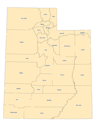
The landlocked U.S. state of Utah is known for its natural diversity and is home to features ranging from arid deserts with sand dunes to thriving pine forests in mountain valleys. It is a rugged and geographically diverse state at the convergence of three distinct geological regions: the Rocky Mountains, the Great Basin, and the Colorado Plateau.

<span class="mw-page-title-main">Beury Mountain Wildlife Management Area</span> State Wildlife Management Area in Fayette County, West Virginia

Beury Mountain Wildlife Management Area is located on 9,232 acres (3,736 ha) near Babcock State Park and New River Gorge National River in Fayette County, West Virginia. Beury Mountain's sloping terrain is covered with mixed hardwoods and oak-hickory second growth woodlands overlooking New River Gorge. Camping is not allowed at Beury Mountain WMA, but is available at nearby Babcock State Park.

The former Briery Mountain Wildlife Management Area was located on 1,162 acres (470 ha) near Kingwood in Preston County, West Virginia. The wildlife management area was part of the Camp Dawson Army Training Center, owned by the West Virginia State Armory Board. Briery Mountain WMA was sited on Briery Mountain, overlooking Camp Dawson and the Cheat River valley. The land had been cooperatively managed by the WV State Armory Board and the WV Division of Natural Resources. Construction of a live-fire range forced the permanent closure of the WMA.

<span class="mw-page-title-main">Burches Run Wildlife Management Area</span> State Wildlife Management Area in Marshall County, West Virginia

Burches Run Wildlife Management Area, formerly Burches Run Lake WMA, is located on 55 acres (22 ha) near Wheeling in Marshall County, West Virginia. Until 2005 the wildlife management area contained a lake impounded by a dam at risk of failure. The name change occurred after the dam was removed. The terrain climbs gently above Burches Run and is covered by a mature oak-hickory second-growth forest.

<span class="mw-page-title-main">Bluestone Wildlife Management Area</span> State Wildlife Management Area in Mercer, Monroe, and Summers counties, West Virginia

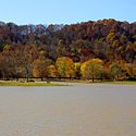
Bluestone Wildlife Management Area is a wildlife management area in southern West Virginia surrounding Bluestone Lake and the New River. The section of the lake from just upstream of the Bluestone River to Bluestone Dam is in Bluestone State Park; the rest of the lake in West Virginia basin comprises Bluestone WMA. All together, the WMA comprises 18,019 acres (72.92 km2) of land and water.

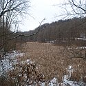
The former Fork Creek Wildlife Management Area was located on 7,000 acres (2,800 ha) in Boone County near Nellis, West Virginia. The steep terrain and narrow valleys are mostly covered with second-growth mixed hardwoods.

<span class="mw-page-title-main">Laurel Lake Wildlife Management Area</span>

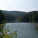
Laurel Lake Wildlife Management Area is located between Dingess and Lenore in Mingo County, West Virginia. Located on 12,856 acres (5,203 ha) of steep terrain with narrow valleys and ridgetops, the WMA contains second growth mixed hardwoods and hemlock with thick understory of mountain laurel and rhododendron.

The former Springfield Wildlife Management Area was located on approximately 1,700 acres (690 ha) in Hampshire County near Springfield, West Virginia. Created during the 1970s, the land was owned by MeadWestvaco.

References

  1. "West Virginia State Parks Facilities Grid" (PDF). West Virginia State Parks. Archived from the original (PDF) on 2009-03-26. Retrieved 2009-03-14.
  2. "Public Shooting Ranges in West Virginia". West Virginia Division of Natural Resources. Archived from the original on 2009-03-15. Retrieved 2009-03-14.
  3. "Beury Mountain WMA in Fayette County Extended; National Wild Turkey Federation Supports Land Acquisition". West Virginia Division of Natural Resources. 2008-10-17. Archived from the original on 2012-02-13. Retrieved 2009-03-14.
  4. "New River Gorge land to be added to preserve". Charleston Gazette . February 2, 2010. Archived from the original on July 27, 2011. Retrieved February 3, 2010.
  5. "DNR Acquires Two New Wildlife Management Areas in Preston County". West Virginia Division of Natural Resources. October 9, 2014. Archived from the original on December 3, 2014. Retrieved November 16, 2014.
  6. Wolford, Michelle (September 28, 2011). "Hunting Banned at Briery Mountain". The Dominion Post . Morgantown, West Virginia. Archived from the original on January 21, 2013. Retrieved September 28, 2011.
  7. "Fork Creek Wildlife Management Area Closes". West Virginia Division of Natural Resources. Archived from the original on 2008-12-12. Retrieved 2009-03-14.
  8. "Springfield Wildlife Management Area Lease Agreement Will Not Be Renewed". West Virginia Division of Natural Resources. Archived from the original on April 17, 2015. Retrieved April 12, 2015.

See also