Related Research Articles

Gaping Gill is a natural cave in North Yorkshire, England. It is one of the unmistakable landmarks on the southern slopes of Ingleborough – a 98-metre (322 ft) deep pothole with the stream Fell Beck flowing into it. After falling through one of the largest known underground chambers in Britain, the water disappears into the bouldery floor and eventually resurges adjacent to Ingleborough Cave.

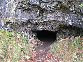
Ogof Craig a Ffynnon is a cave in Wales. The cave is about 7 km in length and is located at the base of a quarried rockface in the Clydach Gorge. Water flowing out of the cave is a resurgence of water draining off Llangatock Mountain above.

The Cave Diving Group (CDG) is a United Kingdom-based diver training organisation specialising in cave diving.
Ogof Ffynnon Ddu, also known informally as OFD, is a cave under a hillside in the area surrounding Penwyllt in the Upper Swansea Valley in South Wales. It is the second longest cave in Wales and the deepest in the United Kingdom.

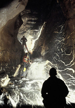
A pit cave, shaft cave or vertical cave—or often simply called a pit and pothole or pot ; jama in Slavic languages scientific and colloquial vocabulary —is a type of cave which contains one or more significant vertical shafts rather than being predominantly a conventional horizontal cave passage. Pits typically form in limestone as a result of long-term erosion by water. They can be open to the surface or found deep within horizontal caves. Among cavers, a pit is a vertical drop of any depth that cannot be negotiated safely without the use of ropes or ladders.

Eastwater Cavern is a cave near Priddy in the limestone of the Mendip Hills, in Somerset, England. It is also known as Eastwater Swallet. It was first excavated in April 1902 by a team led by Herbert E. Balch composed of paid labourers and volunteers from the Wells Natural History Society. Progress was initially slow, but by February 1903 Balch and Willcox had discovered substantial passage, following the streamway down to the bottom of the cave. Dolphin Pot was dug in 1940 by the Wessex Cave Club, with Primrose Pot following in 1950. West End series was the most recent significant discovery, in 1983.

St Cuthbert's Swallet is the second longest, and most complex, cave on the Mendip Hills, in Somerset, England. It forms a major part of the Priddy Caves system and water entering this swallet re-emerges at Wookey Hole. St Cuthbert's Swallet is part of, and lies underneath, the Priddy Pools Site of Special Scientific Interest.

Great Douk Cave is a shallow cave system lying beneath the limestone bench of Ingleborough in Chapel-le-Dale, North Yorkshire, England. It is popular with beginners and escorted groups, as it offers straightforward caving, and it is possible to follow the cave from where a stream emerges at a small waterfall to a second entrance close to where it sinks 600 yards (549 m) further up the hill. It lies within the Ingleborough Site of Special Scientific Interest.
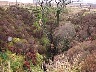
Rumbling Hole is a cave on Leck Fell, in Lancashire, England. Its entrance is a 50-metre (160 ft) deep fenced shaft, and it rapidly descends a series of pitches to a low aqueous passage that has been connected to Lost Johns' Cave. It is part of the Three Counties System, an 87-kilometre (54 mi) cave system that spans the borders of Cumbria, Lancashire, and North Yorkshire.

Leck Fell is a Site of Special Scientific Interest in Lancashire, England. An area of typically heavily grazed open moorland of rough grass and remnant patches of heather with little or no tree cover, it is characterised by the virtual absence of surface drainage and an extensive subterranean drainage network resulting in cave systems and numerous sinkholes. It surrounds the high point of Gragareth 627 metres (2,057 ft) between Leck Beck and Kingsdale.
Langcliffe Pot is a cave system on the slopes of Great Whernside in Upper Wharfedale, about 3 kilometres (1.9 mi) SSE of Kettlewell in North Yorkshire. It is part of the Black Keld Site of Special Scientific Interest where the "underground drainage system which feeds the stream resurgence at Black Keld is one of the largest and deepest in Britain, although only a small proportion of its cave passages are accessible at present." Mossdale Caverns is also part of the Black Keld SSSI. Although a considerable length of passage has been explored in Langcliffe Pot, the current end is over 170 metres (560 ft) above the resurgence, and over 4 kilometres (2.5 mi) in distance. A trip to the far end has been described as "one of the most serious undertakings in British caving".

Carreg Cadno is a hill five miles northeast of Abercraf in the county of Powys, south Wales. It lies within the Brecon Beacons National Park and Fforest Fawr Geopark. Its summit at OS grid ref SN 874161 reaches a height of 538m / 1763 ft above sea level. The hill is within the Ogof Ffynnon Ddu National Nature Reserve which is owned and managed by the Countryside Council for Wales.
The Nidderdale Caves are a series of caves in Upper Nidderdale in North Yorkshire, England. There are two cave systems and most of the caves are in some way linked with one or the other. The smaller system is the Eglin cave system in the valley of How Stean Beck, a tributary of the River Nidd, associated with How Stean Gorge. The larger system is the Goyden cave system under the valley of the River Nidd, which flows east from Scar House Reservoir, then south, and shortly after disappears underground down several sinkholes to reappear at the rising just beyond the village of Lofthouse. Cavers can access several sections of this system via the different entrances.

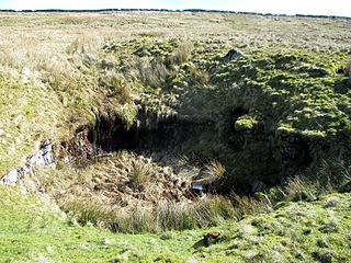
Short Drop Cave and Gavel Pot are different entrances into the same cave system on Leck Fell, in Lancashire, England. The main top entrance, Short Drop Cave, is a small hole in a fenced off shakehole near the main stream sink; Gavel Pot, a window into the system, is a large fenced shakehole some 40-metre (130 ft) deep requiring tackle to descend. There are two other smaller entrances into Short Drop Cave. At its base the system links via a sump with Lost Johns' Cave, and is part of the Three Counties System, an 87 kilometres (54 mi) cave system which spans the borders of Cumbria, Lancashire, and North Yorkshire.
Flood Entrance Pot is one of the entrances to the Gaping Gill cave system located about 300 metres (330 yd) south of Gaping Gill Main Shaft. It was the first alternative entrance into the main system to be explored, and it is now a popular entrance into the system, with a fine 38-metre (125 ft) pitch landing in Gaping Gill's South-East Passage. It lies within the designated Ingleborough Site of Special Scientific Interest.
Yordas Cave is a solutional cave in Kingsdale, North Yorkshire, England. It has been renowned since the eighteenth century as a natural curiosity, and was a show cave during the nineteenth century. It is now a popular destination for cavers, walkers, and outdoor activity groups.

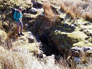
Death's Head Hole is a cave on Leck Fell, in Lancashire, England. Its entrance is a 64-metre (210 ft) deep shaft. It leads into Lost Johns' Cave and is part of the Three Counties System, an 87-kilometre (54 mi) cave system which spans the borders of Cumbria, Lancashire, and North Yorkshire.

The Three Counties System is a set of inter-connected limestone solutional cave systems spanning the borders of Cumbria, Lancashire and North Yorkshire in the north of England. The possibility of connecting a number of discrete cave systems in the area to create a single super-system that spans the county borders was first proposed by Dave Brook in 1968, and it was achieved in 2011. The system is currently over 86 kilometres (53 mi) long, making it the longest in the UK and the thirtieth longest in the world, and there continues to be scope for considerably extending the system.

Niggly/Growling Swallet cave system (JF-237), Tasmania is the deepest cave in Australia.
References
- ↑ Allen, Tim (Oct–Nov 2014). "The Longest Cave". Descent (240). Wild Places Publishing: 36.
- ↑ "Ogof Ffynnon Ddu - Surveys". South Wales Caving Club. Retrieved 21 September 2015.
- ↑ "Scottish Cave and Mine Database. Grampian Speleological Group
- ↑ " 'Biggest cave' is Calders Geo in Shetland at Esha Ness". BBC News. Retrieved 28 August 2014.
- ↑ "Esha Ness sea cave is 'largest in Britain'". BBC News. Retrieved 28 August 2014.
- ↑ "Cheddar cave 'biggest in Mendip Hills'". BBC News online. 7 September 2012. Retrieved 16 September 2012.