List of cities and towns in Angola

Last updated

Contents

This is a list of cities and towns in Angola .

Name of town or city Coordinates Pop. 2014/18 Province
Alto Cauale 9°8′S14°46′E / 9.133°S 14.767°E / -9.133; 14.767 (Alto Cauale) 104,000 Uíge
Alto Zambeze 11°54′21″S22°55′18″E / 11.90583°S 22.92167°E / -11.90583; 22.92167 (Alto Zambeze) 20,000 Moxico
Ambaca 8°11′S15°22′E / 8.183°S 15.367°E / -8.183; 15.367 (Ambaca) 61,769 Cuanza Norte
Ambriz 7°52′S13°07′E / 7.86°S 13.12°E / -7.86; 13.12 (Ambriz) 22,712 Bengo
Ambuila 7°26′S14°39′E / 7.433°S 14.650°E / -7.433; 14.650 (Ambuila) 18,118 Uíge
Andulo 11°29′S16°41′E / 11.48°S 16.69°E / -11.48; 16.69 (Andulo) 258,161 Bié
Baía Farta 12°37′S13°11′E / 12.61°S 13.19°E / -12.61; 13.19 (Baía Farta) 107,841 Benguela
Bailundo 12°11′S15°52′E / 12.19°S 15.86°E / -12.19; 15.86 (Bailundo) 294,494 Huambo
Balombo 12°22′S14°46′E / 12.36°S 14.77°E / -12.36; 14.77 (Balombo) 108,965 Benguela
Benguela 12°35′S13°24′E / 12.58°S 13.40°E / -12.58; 13.40 (Benguela) 131,281 Benguela
Bibala (Vila Arriaga) 14°46′S13°21′E / 14.76°S 13.35°E / -14.76; 13.35 (Bibala) 5,165 Namibe
Biula 11°11′S20°13′E / 11.18°S 20.22°E / -11.18; 20.22 (Biula) 4,381 Lunda Sul
Bungo 7°26′S15°23′E / 7.44°S 15.39°E / -7.44; 15.39 (Bungo) 3,461 Uíge
Cabamba 8°21′S17°31′E / 8.35°S 17.51°E / -8.35; 17.51 (Cabamba) 4,109 Malanje
Cabinda (Kabinda) 5°34′S12°11′E / 5.56°S 12.19°E / -5.56; 12.19 (Cabinda) 377,931 Cabinda
Caboledo 9°40′S13°14′E / 9.66°S 13.24°E / -9.66; 13.24 (Caboledo) 3,966 Bengo
Cacolo 10°09′S19°16′E / 10.15°S 19.26°E / -10.15; 19.26 (Cacolo) 4,521 Lunda Sul
Caconda 13°44′S15°04′E / 13.73°S 15.06°E / -13.73; 15.06 (Caconda) 3,497 Huíla
Cacondá 12°52′S15°35′E / 12.87°S 15.58°E / -12.87; 15.58 (Cacondá) Huambo
Caculama 9°29′S16°51′E / 9.48°S 16.85°E / -9.48; 16.85 (Caculama) 3,897 Malanje
Cacuso 9°26′S15°44′E / 9.43°S 15.74°E / -9.43; 15.74 (Cacuso) 5,020 Malanje
Cafunfo 8°46′S18°00′E / 8.77°S 18.00°E / -8.77; 18.00 (Cafunfo) 23,066 Lunda Norte
Cahama 16°17′S14°18′E / 16.29°S 14.30°E / -16.29; 14.30 (Cahama) 4,282 Cunene
Caiengue 12°26′S15°43′E / 12.43°S 15.71°E / -12.43; 15.71 (Caiengue) 3,883 Huambo
Caimbambo 13°02′S14°01′E / 13.03°S 14.01°E / -13.03; 14.01 (Caimbambo) 14,806 Benguela
Calandala 9°13′S17°59′E / 9.21°S 17.98°E / -9.21; 17.98 (Calandala) 5,386 Lunda Norte
Calenga (Kalenga) 12°51′S15°28′E / 12.85°S 15.47°E / -12.85; 15.47 (Calenga) 13,082 Huambo
Calonda 8°28′S20°33′E / 8.47°S 20.55°E / -8.47; 20.55 (Calonda) 3,944 Lunda Norte
Calucinga 11°19′S16°12′E / 11.32°S 16.20°E / -11.32; 16.20 (Calucinga) 4,106 Bié
Calulo 10°00′S14°54′E / 10.00°S 14.90°E / -10.00; 14.90 (Calulo) 5,656 Cuanza Sul
Caluquembe (Kalukembe) 13°47′S14°47′E / 13.78°S 14.78°E / -13.78; 14.78 (Caluquembe) 25,348 Huíla
Camabatela 8°11′S15°22′E / 8.19°S 15.37°E / -8.19; 15.37 (Camabatela) 8,691 Cuanza Norte
Camacupa (General Machado, Vila General Machado) 12°01′S17°28′E / 12.02°S 17.47°E / -12.02; 17.47 (Camacupa) 12,463 Bié
Camanongue (Buçaco, Kamenongue) 11°26′S20°10′E / 11.44°S 20.16°E / -11.44; 20.16 (Camanongue) 4,114 Moxico
Camaxilo 8°20′S18°55′E / 8.34°S 18.91°E / -8.34; 18.91 (Camaxilo) 4,639 Lunda Norte
Cambambe 8°22′S17°40′E / 8.37°S 17.67°E / -8.37; 17.67 (Cambambe) 4,302 Lunda Norte
Cambongue 15°09′S12°10′E / 15.15°S 12.17°E / -15.15; 12.17 (Cambongue) 3,638 Namibe
Cambundi (Nova Gaia, Catembo) 10°05′S17°33′E / 10.08°S 17.55°E / -10.08; 17.55 (Cambundi) 5,043 Malanje
Camissombo (Veríssimo Sarmento) 8°10′S20°40′E / 8.16°S 20.66°E / -8.16; 20.66 (Camissombo) 3,649 Lunda Norte
Candjimbe 12°16′S15°14′E / 12.27°S 15.23°E / -12.27; 15.23 (Candjimbe) 6,401 Huambo
Cangamba (Vila de Aljustrel) 13°42′S19°52′E / 13.70°S 19.86°E / -13.70; 19.86 (Cangamba) 3,414 Moxico
Cangandala 9°47′S16°26′E / 9.79°S 16.43°E / -9.79; 16.43 (Cangandala) 4,048 Malanje
Cangumbe 11°58′S19°12′E / 11.96°S 19.20°E / -11.96; 19.20 (Cangumbe) 4,849 Moxico
Capelongo (Cubango, Kuvango) 14°28′S16°17′E / 14.47°S 16.29°E / -14.47; 16.29 (Capelongo) 11,098 Huíla
Capenda Camulemba 9°25′S18°26′E / 9.42°S 18.43°E / -9.42; 18.43 (Capenda Camulemba) 3,562 Lunda Norte
Capulo 7°57′S13°10′E / 7.95°S 13.17°E / -7.95; 13.17 (Capulo) 13,157 Bengo
Cassanguide (Cassanguidi) 7°29′S21°18′E / 7.49°S 21.30°E / -7.49; 21.30 (Cassanguide) 3,615 Lunda Norte
Cassongue 11°51′S15°03′E / 11.85°S 15.05°E / -11.85; 15.05 (Cassongue) 4,682 Cuanza Sul
Catabola (Katabola, Chissamba, Nova Sintra) 12°09′S17°17′E / 12.15°S 17.28°E / -12.15; 17.28 (Catabola) 22,790 Bié
Catacanha 8°04′S13°14′E / 8.06°S 13.23°E / -8.06; 13.23 (Catacanha) 5,635 Bengo
Catchiungo (Katchiungo, Katchungo, Cantchiungo) 12°34′S16°13′E / 12.56°S 16.22°E / -12.56; 16.22 (Catchiungo) 15,566 Huambo
Catumbela 12°26′S13°33′E / 12.43°S 13.55°E / -12.43; 13.55 (Catumbela) 14,862 Benguela
Caungula 8°05′S19°05′E / 8.08°S 19.08°E / -8.08; 19.08 (Caungula)   Lunda Norte
Caxita Cameia 8°25′S17°27′E / 8.42°S 17.45°E / -8.42; 17.45 (Caxita Cameia) 11,013 Malanje
Caxito 8°35′S13°40′E / 8.58°S 13.66°E / -8.58; 13.66 (Caxito) 11,749 Bengo
Cazaje (Cazage) 11°04′S20°43′E / 11.07°S 20.71°E / -11.07; 20.71 (Cazaje) 6,539 Lunda Sul
Cazombo 11°53′S22°54′E / 11.89°S 22.90°E / -11.89; 22.90 (Cazombo) 13,318 Moxico
Caála (Kaala, Kahala, Robert Williams, Vila Robert Williams) 12°51′S15°34′E / 12.85°S 15.56°E / -12.85; 15.56 (Caála) 41,181 Huambo
Cela 11°25′S15°07′E / 11.42°S 15.12°E / -11.42; 15.12 (Cela) 3,603 Cuanza Sul
Chiange (Gambos) 15°44′S13°53′E / 15.74°S 13.89°E / -15.74; 13.89 (Chiange) 4,152 Huíla
Chibanda 12°10′S16°45′E / 12.16°S 16.75°E / -12.16; 16.75 (Chibanda) 4,846 Bié
Chibemba 15°45′S14°05′E / 15.75°S 14.08°E / -15.75; 14.08 (Chibemba) 3,741 Huíla
Chibia 15°11′S13°41′E / 15.19°S 13.69°E / -15.19; 13.69 (Chibia) 3,678 Huíla
Chicala 11°56′S19°38′E / 11.94°S 19.63°E / -11.94; 19.63 (Chicala) 3,523 Moxico
Chingufo 7°37′S20°32′E / 7.62°S 20.53°E / -7.62; 20.53 (Chingufo) 3,903 Lunda Norte
Chipindo 13°50′S15°48′E / 13.83°S 15.80°E / -13.83; 15.80 (Chipindo) 13,723 Huíla
Chissamba 12°09′54″S17°19′19″E / 12.165°S 17.322°E / -12.165; 17.322 (Chissamba)   Bié
Chitado 17°19′S13°55′E / 17.32°S 13.92°E / -17.32; 13.92 (Chitado) 3,656 Cunene
Chitembo 13°31′S16°45′E / 13.52°S 16.75°E / -13.52; 16.75 (Chitembo) 3,971 Bié
Coemba 12°09′S18°05′E / 12.15°S 18.09°E / -12.15; 18.09 (Coemba) 4,608 Bié
Colui (Candingo) 14°31′S16°00′E / 14.52°S 16.00°E / -14.52; 16.00 (Colui) 5,093 Huíla
Conda 11°07′S14°20′E / 11.11°S 14.34°E / -11.11; 14.34 (Conda) 7,315 Cuanza Sul
Cota 9°16′S16°06′E / 9.27°S 16.10°E / -9.27; 16.10 (Cota) 4,677 Malanje
Coutada 17°01′S21°18′E / 17.02°S 21.30°E / -17.02; 21.30 (Coutada) 3,821 Cuando Cubango
Cuangar 17°37′S18°37′E / 17.61°S 18.62°E / -17.61; 18.62 (Cuangar) 3,897 Cuando Cubango
Cuango-Luzamba (Kwango, Luzamba, Cuango) 9°07′S18°02′E / 9.12°S 18.04°E / -9.12; 18.04 (Cuango-Luzamba) 11,709 Lunda Norte
Cuasa 11°21′S21°49′E / 11.35°S 21.82°E / -11.35; 21.82 (Cuasa) 3,518 Moxico
Cubal 13°02′S14°14′E / 13.04°S 14.24°E / -13.04; 14.24 (Cubal) 41,142 Benguela
Cuchi 14°40′S16°53′E / 14.66°S 16.89°E / -14.66; 16.89 (Cuchi) 16,274 Cuando Cubango
Cuilo 8°14′S19°31′E / 8.24°S 19.52°E / -8.24; 19.52 (Cuilo) 3,890 Lunda Norte
Cuima 13°14′S15°38′E / 13.24°S 15.64°E / -13.24; 15.64 (Cuima) 6,546 Huambo
Cuimba 6°07′S14°37′E / 6.12°S 14.62°E / -6.12; 14.62 (Cuimba) 13,927 Zaire
Cuito Cuanavale 15°10′S19°10′E / 15.16°S 19.17°E / -15.16; 19.17 (Cuito Cuanavale) 8,702 Cuando Cubango
Cuvelai 15°40′S15°48′E / 15.66°S 15.80°E / -15.66; 15.80 (Cuvelai) 5,737 Cunene
Dala 11°02′S20°12′E / 11.03°S 20.20°E / -11.03; 20.20 (Dala) 4,168 Lunda Sul
Damba 6°41′S15°08′E / 6.68°S 15.13°E / -6.68; 15.13 (Damba) 3,827 Uíge
Didimbo 17°30′S21°45′E / 17.500°S 21.750°E / -17.500; 21.750 (Didimbo)
Dombe Grande 12°57′S13°06′E / 12.95°S 13.10°E / -12.95; 13.10 (Dombe Grande) 18,208 Benguela
Dondo 9°41′S14°26′E / 9.69°S 14.43°E / -9.69; 14.43 (Dondo) 30,338 Cuanza Norte
Dongo 14°35′S15°44′E / 14.59°S 15.73°E / -14.59; 15.73 (Dongo) 9,134 Huíla
Dundo (Chitato) 7°23′S20°50′E / 7.38°S 20.83°E / -7.38; 20.83 (Dundo) 40,055 Lunda Norte
Ekunha (Vila Flor) 12°41′S15°31′E / 12.68°S 15.51°E / -12.68; 15.51 (Ekunha) 5,948 Cunene
Folgares 14°53′S15°05′E / 14.89°S 15.08°E / -14.89; 15.08 (Folgares) 6,380 Huíla
Funda 8°51′S13°33′E / 8.85°S 13.55°E / -8.85; 13.55 (Funda) 3,479 Bengo
Gabela 10°51′S14°22′E / 10.85°S 14.37°E / -10.85; 14.37 (Gabela) 4,442 Cuanza Sul
Galo 11°21′S14°20′E / 11.35°S 14.34°E / -11.35; 14.34 (Galo) 5,241 Cuanza Sul
Ganda 13°02′S14°38′E / 13.03°S 14.63°E / -13.03; 14.63 (Ganda) 26,118 Benguela
Golungo Alto 9°08′S14°46′E / 9.14°S 14.77°E / -9.14; 14.77 (Golungo Alto) 7,142 Cuanza Norte
Guri 8°23′S17°41′E / 8.39°S 17.69°E / -8.39; 17.69 (Guri) 3,583 Lunda Norte
Huambo (Nova Lisboa) 12°46′S15°44′E / 12.77°S 15.74°E / -12.77; 15.74 (Huambo) 333,387 Huambo
Humpata 15°01′S13°22′E / 15.01°S 13.37°E / -15.01; 13.37 (Humpata) 4,122 Huíla
Jamba 17°28′S22°37′E / 17.46°S 22.61°E / -17.46; 22.61 (Jamba, Cuando Cubango)   Cuando Cubango
Jamba 14°41′S16°04′E / 14.69°S 16.06°E / -14.69; 16.06 (Jamba, Huíla)   Huíla
Kuito (Bié, Silva Porto) 12°23′S16°56′E / 12.38°S 16.94°E / -12.38; 16.94 (Kuito) 180,764 Bié
Leúa 11°39′S20°26′E / 11.65°S 20.44°E / -11.65; 20.44 (Leúa) 5,411 Moxico
Lobito 12°22′S13°32′E / 12.36°S 13.53°E / -12.36; 13.53 (Lobito) 145,652 Benguela
Lombe 9°29′S16°09′E / 9.49°S 16.15°E / -9.49; 16.15 (Lombe) 3,619 Malanje
Longa 14°37′S18°29′E / 14.61°S 18.48°E / -14.61; 18.48 (Longa) 3,403 Cuando Cubango
Longonjo 12°55′S15°15′E / 12.91°S 15.25°E / -12.91; 15.25 (Longonjo) 5,259 Huambo
Luacano (Dilolo) 11°13′S21°39′E / 11.22°S 21.65°E / -11.22; 21.65 (Luacano) 7,179 Moxico
Luanda (Loanda, São Paulo de Loanda) 8°49′S13°14′E / 8.82°S 13.24°E / -8.82; 13.24 (Luanda) 2,583,981 Luanda
Luau 10°37′S14°58′E / 10.62°S 14.97°E / -10.62; 14.97 (Luau, Cuanza Sul)   Cuanza Sul
Luau (Vila Teixeira de Sousa) 10°43′S22°14′E / 10.71°S 22.23°E / -10.71; 22.23 (Luau, Moxico) 7,951 Moxico
Lubango (Sá da Bandeira) 14°55′S13°29′E / 14.91°S 13.49°E / -14.91; 13.49 (Lubango) 250,921 Huíla
Lucala 9°16′S15°14′E / 9.27°S 15.24°E / -9.27; 15.24 (Lucala) 3,849 Cuanza Norte
Lucapa (Lukapa) 8°25′S20°44′E / 8.42°S 20.74°E / -8.42; 20.74 (Lucapa) 27,236 Lunda Norte
Lucusse 12°32′S20°49′E / 12.53°S 20.81°E / -12.53; 20.81 (Lucusse) 3,542 Moxico
Luena (Lwena, Luso, Vila Luso) 11°47′S19°54′E / 11.79°S 19.90°E / -11.79; 19.90 (Luena) 84,619 Moxico
Luiana 17°22′S23°00′E / 17.37°S 23.00°E / -17.37; 23.00 (Luiana) 3,577 Cuando Cubango
Luimbale (Londuimbali) 12°14′S15°19′E / 12.24°S 15.31°E / -12.24; 15.31 (Luimbale) 5,390 Huambo
Luma Cassao 11°14′S19°46′E / 11.24°S 19.76°E / -11.24; 19.76 (Luma Cassao) 3,597 Lunda Sul
Lumbala N'guimbo (Lumbala) 14°06′S21°26′E / 14.10°S 21.44°E / -14.10; 21.44 (Lumbala) 3,936 Moxico
Lumeje 11°34′S20°47′E / 11.56°S 20.78°E / -11.56; 20.78 (Lumeje) 3,591 Moxico
Luremo 8°31′S17°50′E / 8.52°S 17.83°E / -8.52; 17.83 (Luremo) 3,890 Lunda Norte
Luxanraigoto 56,612
Luxilo 7°35′S21°21′E / 7.59°S 21.35°E / -7.59; 21.35 (Luxilo) 3,785 Lunda Norte
Lândana (Cacongo) 5°14′S12°08′E / 5.23°S 12.14°E / -5.23; 12.14 (Lândana) 16,783 Cabinda
M'Bimbi (Bimbe) 11°49′S15°49′E / 11.82°S 15.82°E / -11.82; 15.82 (Bimbe) 3,463 Huambo
Malanje (Malange) 9°32′S16°20′E / 9.54°S 16.34°E / -9.54; 16.34 (Malanje) 156,829 Malanje
Malembo 5°20′S12°11′E / 5.34°S 12.19°E / -5.34; 12.19 (Malembo) 7,382 Cabinda
Maludi 8°01′S21°17′E / 8.02°S 21.29°E / -8.02; 21.29 (Maludi) 5,918 Lunda Norte
Marimba 8°22′S17°01′E / 8.36°S 17.02°E / -8.36; 17.02 (Marimba) 4,691 Malanje
Marimbanguengo 8°10′S17°29′E / 8.17°S 17.49°E / -8.17; 17.49 (Marimbanguengo) 4,371 Malanje
Massango 8°02′S16°20′E / 8.04°S 16.34°E / -8.04; 16.34 (Massango) 4,302 Malanje
Matala 14°44′S15°02′E / 14.74°S 15.03°E / -14.74; 15.03 (Matala) 33,231 Huíla
Mavinga 15°47′S20°22′E / 15.79°S 20.36°E / -15.79; 20.36 (Mavinga) 4,442 Cuando Cubango
Mbanza-Congo (M'banza-Kongo, São Salvador, São Salvador do Congo) 6°16′S14°14′E / 6.27°S 14.24°E / -6.27; 14.24 (Mbanza-Congo) 30,768 Zaire
Menongue (Vila Serpa, Pinto, Serpa Pinto) 14°40′S17°41′E / 14.66°S 17.69°E / -14.66; 17.69 (Menongue) 31,445 Cuando Cubango
Muchinda 9°20′S18°11′E / 9.33°S 18.19°E / -9.33; 18.19 (Muchinda) 3,695 Lunda Norte
Muconda (Nova Chaves) 10°36′S21°19′E / 10.60°S 21.32°E / -10.60; 21.32 (Muconda) 3,506 Lunda Sul
Mucumbo 7°23′S21°08′E / 7.39°S 21.14°E / -7.39; 21.14 (Mucumbo) 4,846 Lunda Norte
Mucusso 18°01′S21°26′E / 18.02°S 21.43°E / -18.02; 21.43 (Mucusso) 3,959 Cuando Cubango
Mucussueje 11°02′S21°56′E / 11.03°S 21.94°E / -11.03; 21.94 (Mucussueje) 5,643 Moxico
Muginga 8°21′S17°36′E / 8.35°S 17.60°E / -8.35; 17.60 (Muginga) 10,063 Lunda Norte
Mulondo 15°39′S15°12′E / 15.65°S 15.20°E / -15.65; 15.20 (Mulondo) 5,065 Huíla
Mungo 11°50′S16°13′E / 11.84°S 16.22°E / -11.84; 16.22 (Mungo) 6,643 Huambo
Munhango 12°10′S18°33′E / 12.16°S 18.55°E / -12.16; 18.55 (Munhango) 4,022 Moxico
Mussende 10°31′S16°01′E / 10.51°S 16.01°E / -10.51; 16.01 (Mussende) 12,372 Cuanza Sul
Musserra (Mafuca) 7°32′S13°01′E / 7.54°S 13.01°E / -7.54; 13.01 (Musserra) 4,060 Zaire
Mussuco 8°24′S17°43′E / 8.40°S 17.72°E / -8.40; 17.72 (Mussuco) 9,467 Lunda Norte
N'dalatando (Vila Salazar) 9°18′S14°55′E / 9.30°S 14.91°E / -9.30; 14.91 (N'dalatando) 45,295 Cuanza Norte
N'zeto (Nzeto, Ambrizete) 7°14′S12°52′E / 7.23°S 12.86°E / -7.23; 12.86 (N'zeto) 10,479 Zaire
Namacunde (Santa Clara) 17°18′S15°50′E / 17.30°S 15.84°E / -17.30; 15.84 (Namacunde) 3,479 Cunene
Moçâmedes 15°11′S12°10′E / 15.19°S 12.16°E / -15.19; 12.16 (Moçâmedes) 89,442 Namibe
Negage 7°46′S15°16′E / 7.76°S 15.27°E / -7.76; 15.27 (Negage) 37,622 Uíge
Nharea 11°29′S16°58′E / 11.48°S 16.97°E / -11.48; 16.97 (Nharea) 9,496 Bié
Nóqui 5°53′S13°26′E / 5.88°S 13.43°E / -5.88; 13.43 (Nóqui) 3,741 Zaire
Nzagi (Andrada) 7°41′S21°22′E / 7.69°S 21.37°E / -7.69; 21.37 (Nzagi) 22,981 Lunda Norte
Ondjiva 17°04′S15°44′E / 17.07°S 15.73°E / -17.07; 15.73 (Ondjiva) 19,099 Cunene
Pinheiro 12°48′S15°38′E / 12.80°S 15.64°E / -12.80; 15.64 (Pinheiro) 4,713 Huambo
Porto Amboim (Gunza) 10°44′S13°46′E / 10.73°S 13.76°E / -10.73; 13.76 (Porto Amboim) 8,755 Cuanza Sul
Quela 9°16′S17°04′E / 9.27°S 17.07°E / -9.27; 17.07 (Quela) 3,543 Malanje
Quibala (Kibala) 10°44′S14°59′E / 10.73°S 14.98°E / -10.73; 14.98 (Quibala) 4,406 Cuanza Sul
Quibaxe 8°30′S14°35′E / 8.50°S 14.59°E / -8.50; 14.59 (Quibaxe) 4,261 Cuanza Norte
Quicombo (Kikombo) 11°19′S13°49′E / 11.32°S 13.82°E / -11.32; 13.82 (Quicombo) 4,847 Cuanza Sul
Quilengues 14°05′S14°05′E / 14.08°S 14.08°E / -14.08; 14.08 (Quilengues) 6,427 Huíla
Quimavongo 7°37′S13°02′E / 7.62°S 13.03°E / -7.62; 13.03 (Quimavongo) 15,741 Zaire
Quimbango 10°58′S17°34′E / 10.96°S 17.57°E / -10.96; 17.57 (Quimbango) 4,004 Malanje
Quimbele 6°31′S16°13′E / 6.52°S 16.22°E / -6.52; 16.22 (Quimbele) 8,055 Uíge
Quipungo (Gambos) 14°50′S14°33′E / 14.83°S 14.55°E / -14.83; 14.55 (Quipungo) 6,817 Huíla
Quirima 10°54′S18°05′E / 10.90°S 18.08°E / -10.90; 18.08 (Quirima) 6,427 Huíla
Sacomar, (Saco-Mar, Saco Mar) 15°07′S12°12′E / 15.12°S 12.20°E / -15.12; 12.20 (Saco) 5,988 Namibe
Samunona 8°33′S20°30′E / 8.55°S 20.50°E / -8.55; 20.50 (Samunona) 3,910 Lunda Norte
Saurimo(Henrique de Carvalho) 9°40′S20°23′E / 9.66°S 20.39°E / -9.66; 20.39 (Saurimo) 78,417 Lunda Sul
Savate (Candingo) 16°51′S17°59′E / 16.85°S 17.98°E / -16.85; 17.98 (Savate) 4,371 Cuando Cubango
Savungo 10°25′S18°43′E / 10.41°S 18.72°E / -10.41; 18.72 (Savungo) 4,094 Lunda Sul
Songo 7°21′S14°51′E / 7.35°S 14.85°E / -7.35; 14.85 (Songo) 7,633 Uíge
Soyo (Santo António do Zaire) 6°08′S12°22′E / 6.13°S 12.37°E / -6.13; 12.37 (Soyo) 75,224 Zaire
Sumbe (Novo Redondo) 11°13′S13°51′E / 11.21°S 13.85°E / -11.21; 13.85 (Sumbe) 50,458 Cuanza Sul
Tchindjenje (Quingenge) 12°49′S14°56′E / 12.82°S 14.93°E / -12.82; 14.93 (Tchindjenje) 6,304 Huambo
Tchipelongo 16°29′S14°37′E / 16.49°S 14.62°E / -16.49; 14.62 (Tchipelongo) 3,733 Cunene
Techamutete (Chamutete) 15°15′S16°04′E / 15.25°S 16.07°E / -15.25; 16.07 (Techamutete) 4,348 Huíla
Tentativa 8°36′S13°36′E / 8.60°S 13.60°E / -8.60; 13.60 (Tentativa) 3,760 Bengo
Tombua (Tomboa, Tombwa, Tombwe, Porto Alexandre) 15°48′S11°52′E / 15.80°S 11.86°E / -15.80; 11.86 (Tombua) 7,256 Namibe
Tumba 7°25′S21°02′E / 7.42°S 21.03°E / -7.42; 21.03 (Tumba) 4,737 Lunda Norte
Uku (Vila Nova do Seles) 11°24′S14°19′E / 11.40°S 14.31°E / -11.40; 14.31 (Uku) 28,466 Cuanza Sul
Ukuma (Cuma) 12°51′S15°04′E / 12.85°S 15.07°E / -12.85; 15.07 (Ukuma) 11,533 Huambo
Uíge (Uije, Carmona, Vila Marechal Carmona) 7°37′S15°03′E / 7.62°S 15.05°E / -7.62; 15.05 (Uíge) 116,751 Uíge
Viana 8°54′S13°22′E / 8.90°S 13.37°E / -8.90; 13.37 (Viana)   Luanda
Waku Kungo (Waku Kundo, Santa Comba, Buandangue, Uaco Cungo) 11°22′S15°07′E / 11.36°S 15.12°E / -11.36; 15.12 (Waku Kungo) 26,948 Cuanza Sul
Xangongo (Vila Roçades) 16°44′S14°58′E / 16.74°S 14.97°E / -16.74; 14.97 (Xangongo) 8,125 Cunene
Xá-Muteba 9°31′S17°49′E / 9.52°S 17.82°E / -9.52; 17.82 (Xá-Muteba) 3,447 Lunda Norte

Images

Related Research Articles

<span class="mw-page-title-main">Angola</span> Country on the west coast of Southern Africa

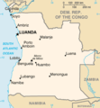
Angola, officially the Republic of Angola, is a country located on the west-central coast of Southern Africa. It is the second-largest Lusophone (Portuguese-speaking) country in both total area and population, and is the seventh-largest country in Africa. It is bordered by Namibia to the south, the Democratic Republic of the Congo to the north, Zambia to the east, and the Atlantic Ocean to the west. Angola has an exclave province, the province of Cabinda, that borders the Republic of the Congo and the Democratic Republic of the Congo. The capital and most populous city is Luanda.

<span class="mw-page-title-main">Luanda</span> Capital of Angola

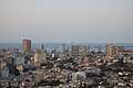
Luanda is the capital and largest city in Angola. It is Angola's primary port, and its major industrial, cultural and urban centre. Located on Angola's northern Atlantic coast, Luanda is Angola's administrative centre, its chief seaport, and also the capital of the Luanda Province. Luanda and its metropolitan area is the most populous Portuguese-speaking capital city in the world and the most populous Lusophone city outside Brazil, with over 8.3 million inhabitants in 2020.

<span class="mw-page-title-main">MPLA</span> Political party in Angola

The People's Movement for the Liberation of Angola, for some years called the People's Movement for the Liberation of Angola – Labour Party, is an Angolan left-wing, social democratic political party. The MPLA fought against the Portuguese army in the Angolan War of Independence from 1961 to 1974, and defeated the National Union for the Total Independence of Angola (UNITA) and the National Liberation Front of Angola (FNLA) in the Angolan Civil War. The party has ruled Angola since the country's independence from Portugal in 1975, being the de facto government throughout the civil war and continuing to rule afterwards.

<span class="mw-page-title-main">Zaire Province</span> Province of Angola

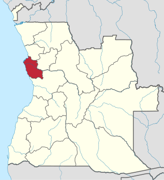
Zaire is one of the 18 provinces of Angola. It occupies 40,130 square kilometres (15,490 sq mi) in the north west of the country and had a population of 594,428 inhabitants in 2014. It is bordered on the west by the Atlantic Ocean, on the north by the Democratic Republic of Congo, on the east by the Uíge Province, and on the south by the Bengo Province.

<span class="mw-page-title-main">Luanda Province</span> Province of Angola

Luanda is a province of Angola. It covers an area of 18,835 km2, and had a population of 6,945,386 at the Census of 16 May 2014. The latest official estimate is 8,247,688.

<span class="mw-page-title-main">Malanje</span> Municipality in Malanje Province, Angola

Malanje is the capital city of Malanje Province in Angola, with a population of 455,000, and a municipality, with a population of 506,847. Projected to be the thirteenth fastest growing city on the African continent between 2020 and 2025, with a 5.17% growth. It is located 380 kilometres (240 mi) east of Angola's capital Luanda. Near it are the spectacular Calandula waterfalls, the rock formations of Pungo Andongo, and the Capanda Dam. The climate is mainly humid, with average temperatures between 20 and 24 °C and rainfall 900 to 130 millimetres in the rainy season.

<span class="mw-page-title-main">Lubango</span> Municipality in Huila, Angola

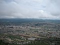
Lubango, formerly known as Sá da Bandeira, is a municipality in Angola, capital of the Huíla Province, with a population of 914,456 in 2022. The city center had a population of 600,751 in 2014 making it the second-most populous city in Angola after the capital city Luanda.

<span class="mw-page-title-main">Lobito</span> Municipality in Benguela Province, Angola

Lobito is a municipality in Angola. It is located in Benguela Province, on the Atlantic Coast north of the Catumbela Estuary. The Lobito municipality had a population of 393,079 in 2014.

<span class="mw-page-title-main">Uíge</span> Municipality and town in Uíge Province, Angola

Uíge, formerly Carmona, is a provincial capital city in northwestern Angola, with a population of 322,531, and a municipality, with a population of 519,196, located in the province of the same name. It grew from a small market centre in 1945 to become a city in 1956.

<span class="mw-page-title-main">Cuíto</span> Municipality in Bié Province, Angola

Cuíto, formerly known as Silva Porto, is a city and municipality in central Angola, capital of Bié Province. The municipality had a population of 450,881 in 2014. Projected to be the tenth fastest growing city on the African continent between 2020 and 2025, with a 5.56% growth.

<span class="mw-page-title-main">N'dalatando</span> Commune in Cuanza Norte, Angola

N'dalatando, formerly Vila Salazar, is a town, with a population of 161,584 (2014), and a commune in the municipality of Cazengo, province of Cuanza Norte, Angola.

<span class="mw-page-title-main">Cabinda (city)</span> Municipality and city in Cabinda province, Angola

Cabinda, also known as Chioua, is a city and a municipality located in the Cabinda Province, an exclave of Angola. Angolan sovereignty over Cabinda is disputed by the secessionist Republic of Cabinda. The city of Cabinda had a population of 550,000 and the municipality a population of 624,646, at the 2014 Census. The residents of the city are known as Cabindas or Fiotes. Cabinda, due to its proximity to rich oil reserves, serves as one of Angola's main oil ports.

<span class="mw-page-title-main">Girabola</span> Football league

Girabola, or Campeonato Nacional de Futebol em Séniores Masculinos, is the top division of Angolan football. It is organized by the Angolan Football Federation.

<span class="mw-page-title-main">Catumbela</span> Municipality and town in Benguela Province, Angola

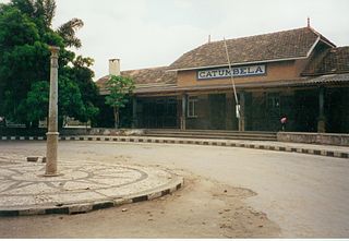
Catumbela is a city and municipality of the Benguela province in Angola. The municipality had a population of 175,805 in 2014.

<span class="mw-page-title-main">Tômbua</span> Municipality in Namibe, Angola

Tômbua, formerly known as Porto Alexandre, is a city and municipality in Angola, in Namibe Province. The municipality has a population of 55,494 and the city has a population of 46,573 in 2014. It is located on the shore of Porto Alexandre, an important harbor on the South Atlantic Ocean for oil production and fishing.

Bula Atumba is a town and municipality in Bengo Province, Angola.

Sanza Pombo is a town and a municipality in Uíge Province in Angola. The municipality had a population of 68,391 in 2014.

<span class="mw-page-title-main">Portuguese Angola</span> 1575–1975 Portuguese possession in West Africa

Portuguese Angola refers to Angola during the historic period when it was a territory under Portuguese rule in southwestern Africa. In the same context, it was known until 1951 as Portuguese West Africa.

The Arquivo Histórico Nacional is the national archive of Angola. Overseen by the Ministry of Culture, it is headquartered in the city of Luanda on Rua Pedro Felix Machado. As of 2016 a new archives building was under construction in Camama. The Arquivo Histórico Nacional originated in the Centro Nacional de Documentação e Investigação Histórica.

References

Bibliography