List of closes on the Royal Mile

Last updated

Part of a model showing the layout of closes off the Royal Mile Model of High Street closes.jpg
Part of a model showing the layout of closes off the Royal Mile
Anchor Close Anchor Close.jpg
Anchor Close

The Old Town of Edinburgh, Scotland, consisted originally of the main street, now known as the Royal Mile, and the small alleyways and courtyards that led off it to the north and south. These were usually named after a memorable occupant of one of the apartments reached by the common entrance, or a trade plied by one or more residents. Generically such an alleyway is termed a close /ˈkls/ , a Scots term for alleyway, although it may be individually named close, entry, court, or wynd. A close is private property, hence gated and closed to the public, whereas a wynd is an open thoroughfare, usually wide enough for a horse and cart [ citation needed ]. Most slope steeply down from the Royal Mile creating the impression of a herring-bone pattern formed by the main street and side streets when viewed on a map. Many have steps and long flights of stairs.

Contents

Because of the need for security within its town walls against English attacks in past wars, Edinburgh experienced a pronounced density in housing. Closes tend to be narrow with tall buildings on both sides, giving them a canyon-like appearance and atmosphere.

The Royal Mile comprises five linear, conjoined streets: Castle Hill; Lawnmarket; High Street; Canongate and Abbey Strand. Closes are listed below from west to east, divided between the south and north sides of the street.

This list names closes currently in existence. Since the Council encourages recreation of closes in new developments the list is not static. New buildings traditionally incorporate the name of the close that historically existed on the same site.

Castlehill

Semple's Close off Castlehill Sempill's Close.JPG
Semple's Close off Castlehill

Castlehill forms the western end of the Royal Mile, running from the Castle Esplanade to the junction of Johnston Terrace.

South

North

Lawnmarket

Fisher's Close off the Lawnmarket Fisher's Close.JPG
Fisher's Close off the Lawnmarket

The Lawnmarket is the section between Johnstone Terrace and George IV Bridge/Bank Street.

South

North

High Street

The High Street runs from St Giles Street to St Mary's Street, the location of the Netherbow Port, and the limit of the pre-19th century burgh of Edinburgh.

Borthwick's Close off the High Street Borthwick's Close.JPG
Borthwick's Close off the High Street
The surface of Marlin's Wynd, one of the suppressed closes of the Royal Mile. It was concealed when built over and rediscovered after excavation in 1974 Marlin's Wynd under the Tron Kirk.JPG
The surface of Marlin's Wynd, one of the suppressed closes of the Royal Mile. It was concealed when built over and rediscovered after excavation in 1974
Head of Advocates Close in the High Street Advocates Close in Edinburgh.jpg
Head of Advocates Close in the High Street
Anchor Close in twilight. Anchor-close.jpg
Anchor Close in twilight.

South

Trunk's Close off the High Street Trunk's Close.JPG
Trunk's Close off the High Street

North

Canongate

The Canongate is the section from St Mary's Street to the foot of the Royal Mile, and connects to Abbey Strand at Holyrood, which ran through the former Burgh of Canongate.

Bakehouse Close off the Canongate Bakehouse Close.JPG
Bakehouse Close off the Canongate

South

White Horse Close off the Canongate, named after the inn from which the Edinburgh-London stagecoach departed. The spacious courtyard allowed the coach to turn. White Horse Close.JPG
White Horse Close off the Canongate, named after the inn from which the Edinburgh-London stagecoach departed. The spacious courtyard allowed the coach to turn.

North

Related Research Articles

<span class="mw-page-title-main">Royal Mile</span> Tourist attraction in Edinburgh

The Royal Mile is a succession of streets forming the main thoroughfare of the Old Town of the city of Edinburgh in Scotland. The term was first used descriptively in W. M. Gilbert's Edinburgh in the Nineteenth Century (1901), describing the city "with its Castle and Palace and the royal mile between", and was further popularised as the title of a guidebook by R. T. Skinner published in 1920, "The Royal Mile (Edinburgh) Castle to Holyrood(house)".

<span class="mw-page-title-main">Alley</span> Narrow street that usually runs between, behind, or within buildings

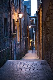
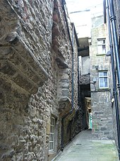
An alley or alleyway is a narrow lane, path, or passageway, often reserved for pedestrians, which usually runs between, behind, or within buildings in the older parts of towns and cities. It is also a rear access or service road, or a path, walk, or avenue in a park or garden.

<span class="mw-page-title-main">Thomas Hamilton (architect)</span> Scottish architect (1784-1858)

Thomas Hamilton was a Scottish architect, based in Edinburgh where he designed many of that city's prominent buildings. Born in Glasgow, his works include: the Burns Monument in Alloway; the Royal High School on the south side of Calton Hill ; the Royal College of Physicians of Edinburgh; the George IV Bridge, which spans the Cowgate; the Dean Orphan Hospital, now the Dean Gallery; the New North Road Free Church, now the Bedlam Theatre; Cumstoun, a private house in Dumfries and Galloway; and the Scottish Political Martyrs' Monument in Old Calton Cemetery, Edinburgh.

<span class="mw-page-title-main">Calton Hill</span> Hill in central Edinburgh, Scotland

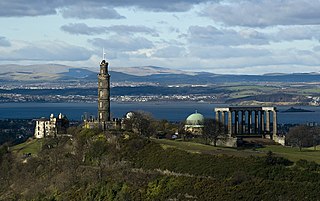
Calton Hill is a hill in central Edinburgh, Scotland, situated beyond the east end of Princes Street and included in the city's UNESCO World Heritage Site. Views of, and from, the hill are often used in photographs and paintings of the city.

<span class="mw-page-title-main">Cowgate</span> Street in Edinburgh, Scotland, UK

The Cowgate is a street in Edinburgh, Scotland, located about 550 yards (500 m) southeast of Edinburgh Castle, within the city's World Heritage Site. The street is part of the lower level of Edinburgh's Old Town, which lies below the elevated streets of South Bridge and George IV Bridge. It meets the Grassmarket at its west end and Holyrood Road to the east.

<span class="mw-page-title-main">Timeline of Edinburgh history</span> Timeline of history in Edinburgh, Scotland

This article is a timeline of the history of Edinburgh, Scotland, up to the present day. It traces its rise from an early hill fort and later royal residence to the bustling city and capital of Scotland that it is today.

Edinburgh, the capital of Scotland, is traditionally said to have been "built on Seven Hills", in an allusion to the seven hills of Rome. While there is considerable room for debate as to which hills are included and excluded from the seven, seven possibilities are listed in an old rhyme:

<span class="mw-page-title-main">Old Town, Edinburgh</span> The oldest part of Edinburgh

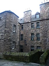
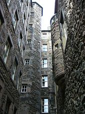
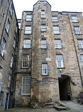
The Old Town is the name popularly given to the oldest part of Scotland's capital city of Edinburgh. The area has preserved much of its medieval street plan and many Reformation-era buildings. Together with the 18th/19th-century New Town, and West End, it forms part of a protected UNESCO World Heritage Site.

<span class="mw-page-title-main">George IV Bridge</span> Road bridge in Edinburgh, Scotland

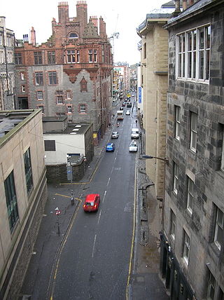
George IV Bridge is an elevated street in Edinburgh, Scotland, and is home to a number of the city's important public buildings.

<span class="mw-page-title-main">Younger's Brewery</span>

Younger's Brewery was a brewery in Edinburgh which grew from humble beginnings in 1749 to become one of the city’s main commercial enterprises, supplying domestic and foreign markets. It should not be confused with another, less renowned Edinburgh brewery, that of Robert Younger, who also brewed in Holyrood at the St. Ann's Brewery or that of George Younger, who brewed in Alloa.

<span class="mw-page-title-main">Edinburgh town walls</span> City walls in City of Edinburgh, Scotland, UK

There have been several town walls around Edinburgh, Scotland, since the 12th century. Some form of wall probably existed from the foundation of the royal burgh in around 1125, though the first building is recorded in the mid-15th century, when the King's Wall was constructed. In the 16th century the more extensive Flodden Wall was erected, following the Scots' defeat at the Battle of Flodden in 1513. This was extended by the Telfer Wall in the early 17th century. The walls had a number of gates, known as ports, the most important being the Netherbow Port, which stood halfway down the Royal Mile. This gave access from the Canongate which was, at that time, a separate burgh.

<span class="mw-page-title-main">Canongate Kirkyard</span> Cemetery in City of Edinburgh, Scotland, UK

The Canongate Kirkyard stands around Canongate Kirk on the Royal Mile in Edinburgh, Scotland. The churchyard was used for burials from the late 1680s until the mid-20th century.

<span class="mw-page-title-main">Lady Yester's Kirk</span> Church in Edinburgh, Scotland

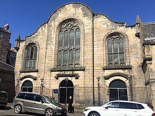
Lady Yester's Kirk was a parish church of the Church of Scotland and one of the burgh churches of Edinburgh. Founded in 1647, it served the south-eastern part of Edinburgh's Old Town until its union with Greyfriars Kirk in 1938.

<span class="mw-page-title-main">White Horse Close</span>

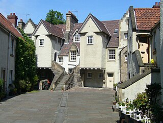
White Horse Close, or "Whitehorse Close", is an enclosed courtyard off the Canongate at the foot of the Royal Mile at the eastern end of the Old Town of Edinburgh, Scotland. It was formerly known as "Ord's Close", after Laurence Ord, the putative builder of the 17th-century inn at its northern end. Because of several conversions to its buildings in the past, the close has been described as "so blatantly fake that it can be acquitted of any intention to deceive". Professor Charles McKean has characterised it as "heritage rather than history".

<span class="mw-page-title-main">Great Fire of Edinburgh</span> City fire in City of Edinburgh, Scotland, UK

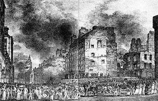
The Great Fire of Edinburgh was one of the most destructive fires in the history of Edinburgh. It started on Monday, 15 November 1824, and lasted for five days, with two major phases.

<span class="mw-page-title-main">Robert Wilson (architect)</span> Scottish architect (1834-1901)

Robert Wilson was architect for the Edinburgh Board of Education and responsible for a high percentage of the city's schools. He is also noteworthy for involvement in several institutions aimed at improving the life of the poor and destitute in the city.

<span class="mw-page-title-main">Walter Merlioun</span> Scottish master mason

Walter Merlioun, was a Scottish master mason based in Edinburgh.

<span class="mw-page-title-main">Kirk o' Field</span> Church in Edinburgh, Scotland

The Collegiate Church of St Mary in the Fields was a pre-Reformation collegiate church in Edinburgh, Scotland. Likely founded in the 13th century and secularised at the Reformation, the church's site is now covered by Old College.

References

  1. Sanderson, Elizabeth C. (23 September 2004), Matthew, H. C. G.; Harrison, B. (eds.), "Ramsay, Katherine (1720s–1808), milliner and shopkeeper" , The Oxford Dictionary of National Biography, Oxford University Press, doi:10.1093/ref:odnb/65566 , retrieved 17 December 2022