List of inhabited islands of Croatia

Last updated
Map of the Croatian islands in the Adriatic Sea Croatia.jpg
Map of the Croatian islands in the Adriatic Sea

In the Croatian part of the Adriatic Sea, there are 718 islands, 389 islets and 78 reefs, [1] making the Croatian archipelago the largest in the Adriatic Sea and the second largest in the Mediterranean Sea, after the Greek archipelago. [2]

Contents

Of the 718 islands, only 47 are inhabited in the sense that at least one person resides on that island. [3] Some sources indicate that Croatia has 67 inhabited islands, [4] counting those that have a settlement, [1] but 20 of those have lost all of their permanent population as a result of the population decline occurring throughout the Croatian islands due to insufficient economic activity. [5]

The Adriatic islands have been populated at least since the time of Ancient Greece. For example, Hvar was already populated between 3500 BC and 2500 BC [6] and Dionysius I of Syracuse founded a colony on Hvar and Vis in the 4th century BC. [7] The combined island population reached its peak in 1921, at 173,503 inhabitants, and went into steady decline in the following decades, dropping to pre-1850s level by 1981. [4] The depopulation trend was reversed only in the 1990s, with the 2001 census registering a population of 122,418, up from 110,953 in 1991. [1]

The main industries on the islands are agriculture, fishing and tourism. The islands' agriculture is primarily devoted to viticulture and olive growing. The local economy is relatively underdeveloped while the cost of living is 10 to 30% higher than on the mainland, [4] so the Croatian government provides various kinds of support and protection through its Islands Act (Croatian : Zakon o otocima) to stimulate the economy of the islands, including charging no tolls on bridges, and providing discounted or free ferry tickets for islanders. [8]

Islands

The harbour of Hvar town, on the island of Hvar Hvar grad.JPG
The harbour of Hvar town, on the island of Hvar
A shoreline of the island of Brac MURVICA BEACH.JPG
A shoreline of the island of Brač
The Kornati archipelago Kornati 2.JPG
The Kornati archipelago
A forest and lake on the island of Mljet Zalazak.jpg
A forest and lake on the island of Mljet
Historic town center of Rab, on the island of Rab Rab1.jpg
Historic town center of Rab, on the island of Rab
A vineyard on the island of Vis Vis vineyard.JPG
A vineyard on the island of Vis
Summer on the island of Krapanj Krapanj sunset2.jpg
Summer on the island of Krapanj
A wind farm on the island of Pag Wind farm Ravna 1, Pag.jpg
A wind farm on the island of Pag
Population density legend
  0 to 10/km2 (0.000 to 0.040/acre)
10 to 50/km2 (0.040 to 0.202/acre)
50 to 100/km2 (0.20 to 0.40/acre)
100 to 150/km2 (0.40 to 0.61/acre)
>150/km2 (0.61/acre)
Data on the populated islands of Croatia
# [note 1] Island County Population [3]
(as of 31 Mar 2011)
Area [3] Highest point [3] Population
density
1 Krk Primorje-Gorski Kotar 19,383405.78 km2 (100,270 acres)568 m (1,864 ft)47.8/km2 (0.193/acre)
2 Korčula Dubrovnik-Neretva 15,522276.03 km2 (68,210 acres)569 m (1,867 ft)56.2/km2 (0.227/acre)
3 Brač Split-Dalmatia 13,956394.57 km2 (97,500 acres)780 m (2,560 ft)35.4/km2 (0.143/acre)
4 Hvar Split-Dalmatia 11,077299.66 km2 (74,050 acres)628 m (2,060 ft)37.0/km2 (0.150/acre)
5 Rab Primorje-Gorski Kotar 9,32890.84 km2 (22,450 acres)410 m (1,350 ft)102.7/km2 (0.416/acre)
6 Pag Lika-Senj and Zadar 9,059284.56 km2 (70,320 acres)349 m (1,145 ft)31.9/km2 (0.129/acre)
7 Lošinj Primorje-Gorski Kotar 7,58774.68 km2 (18,450 acres)589 m (1,932 ft)101.6/km2 (0.411/acre)
8 Ugljan Zadar 6,04950.21 km2 (12,410 acres)286 m (938 ft)120.5/km2 (0.488/acre)
9 Čiovo Split-Dalmatia 5,90828.80 km2 (7,120 acres)217 m (712 ft)205.1/km2 (0.830/acre)
10 Murter Šibenik-Knin 4,89518.60 km2 (4,600 acres)125 m (410 ft)263.2/km2 (1.065/acre)
11 Vis Split-Dalmatia 3,44590.26 km2 (22,300 acres)587 m (1,926 ft)38.2/km2 (0.155/acre)
12 Cres Primorje-Gorski Kotar 3,079405.78 km2 (100,270 acres)639 m (2,096 ft)7.6/km2 (0.031/acre)
13 Vir Zadar 3,00022.38 km2 (5,530 acres)112 m (367 ft)134.0/km2 (0.542/acre)
14 Pašman Zadar 2,84563.34 km2 (15,650 acres)272 m (892 ft)44.9/km2 (0.182/acre)
15 Šolta Split-Dalmatia 1,70058.98 km2 (14,570 acres)236 m (774 ft)28.8/km2 (0.117/acre)
16 Dugi Otok Zadar 1,655114.44 km2 (28,280 acres)337 m (1,106 ft)14.5/km2 (0.059/acre)
17 Mljet Dubrovnik-Neretva 1,088100.41 km2 (24,810 acres)513 m (1,683 ft)10.8/km2 (0.044/acre)
18 Lastovo Dubrovnik-Neretva 79246.87 km2 (11,580 acres)415 m (1,362 ft)16.9/km2 (0.068/acre)
19 Zadar 61517.59 km2 (4,350 acres)168 m (551 ft)35.0/km2 (0.142/acre)
20 Šipan Dubrovnik-Neretva 41915.81 km2 (3,910 acres)224 m (735 ft)26.5/km2 (0.107/acre)
21 Prvić Šibenik-Knin 4032.37 km2 (590 acres)75 m (246 ft)170.0/km2 (0.688/acre)
22 Silba Zadar 29214.98 km2 (3,700 acres)83 m (272 ft)19.5/km2 (0.079/acre)
23 Zlarin Šibenik-Knin 2848.19 km2 (2,020 acres)169 m (554 ft)34.7/km2 (0.140/acre)
24 Vrgada Zadar 2493.7 km2 (910 acres) [9] 115 m (377 ft) [9] 67.3/km2 (0.272/acre)
25 Lopud Dubrovnik-Neretva 2494.63 km2 (1,140 acres) [10] 216 m (709 ft) [10] 53.8/km2 (0.218/acre)
26 Molat Zadar 19722.82 km2 (5,640 acres)148 m (486 ft)8.6/km2 (0.035/acre)
27 Kaprije Šibenik-Knin 1896.97 km2 (1,720 acres)132 m (433 ft)27.1/km2 (0.110/acre)
28 Ist Zadar 1829.7 km2 (2,400 acres) [11] 174 m (571 ft) [11] 18.8/km2 (0.076/acre)
29 Krapanj Šibenik-Knin 1700.36 km2 (89 acres) [12] 1.5 m (4.9 ft) [12] 472.2/km2 (1.911/acre)
30 Koločep Dubrovnik-Neretva 1632.4 km2 (590 acres) [13] 125 m (410 ft) [13] 67.9/km2 (0.275/acre)
31 Susak Primorje-Gorski Kotar 1513.8 km2 (940 acres) [14] 98 m (322 ft) [14] 39.7/km2 (0.161/acre)
32 Drvenik Veli Split-Dalmatia 15012.07 km2 (2,980 acres)178 m (584 ft)10.8/km2 (0.044/acre)
33 Olib Zadar 14026.09 km2 (6,450 acres)74 m (243 ft)5.4/km2 (0.022/acre)
34 Rava Zadar 1173.6 km2 (890 acres) [15] 98 m (322 ft) [15] 32.5/km2 (0.132/acre)
35 Žirje Šibenik-Knin 10315.06 km2 (3,720 acres)134 m (440 ft)6.8/km2 (0.028/acre)
36 Unije Primorje-Gorski Kotar 8816.92 km2 (4,180 acres)132 m (433 ft)5.2/km2 (0.021/acre)
37 Drvenik Mali Split-Dalmatia 873.3 km2 (820 acres) [16] 79 m (259 ft) [16] 26.4/km2 (0.107/acre)
38 Ilovik Primorje-Gorski Kotar 855.2 km2 (1,300 acres) [17] 92 m (302 ft) [17] 16.3/km2 (0.066/acre)
39 Premuda Zadar 649.25 km2 (2,290 acres)88 m (289 ft)6.9/km2 (0.028/acre)
40 Sestrunj Zadar 4815.03 km2 (3,710 acres)185 m (607 ft)3.2/km2 (0.013/acre)
41 Zverinac Zadar 434.2 km2 (1,000 acres) [18] 111 m (364 ft) [18] 10.2/km2 (0.041/acre)
42 Rivanj Zadar 314.4 km2 (1,100 acres) [19] 112 m (367 ft) [19] 7.0/km2 (0.028/acre)
43 Ošljak Zadar 290.3 km2 (74 acres) [20] 90 m (300 ft) [20] 96.7/km2 (0.391/acre)
44 Kornat Šibenik-Knin 1932.30 km2 (7,980 acres)237 m (778 ft)0.6/km2 (0.0024/acre)
45 Biševo Split-Dalmatia 155.8 km2 (1,400 acres) [21] 239 m (784 ft) [21] 2.6/km2 (0.011/acre)
46 Vele Srakane Primorje-Gorski Kotar 31.15 km2 (280 acres) [22] 59 m (194 ft) [22] 2.6/km2 (0.011/acre)
47 Male Srakane Primorje-Gorski Kotar 20.61 km2 (150 acres) [23] 40 m (130 ft) [24] 3.3/km2 (0.013/acre)

See also

Notes

  1. The numbers in the first column of the table indicate each island's rank according to total population.

Related Research Articles

<span class="mw-page-title-main">Rab (island)</span> Island in Croatia

Rab [ɾâːb] is an island in the northern Dalmatia region in Croatia, located just off the northern Croatian coast in the Adriatic Sea.

<span class="mw-page-title-main">Hvar</span> Island in Croatia

Hvar is a Croatian island in the Adriatic Sea, located off the Dalmatian coast, lying between the islands of Brač, Vis and Korčula. Approximately 68 kilometres (42.25 mi) long, with a high east–west ridge of Mesozoic limestone and dolomite, the island of Hvar is unusual in the area for having a large fertile coastal plain, and fresh water springs. Its hillsides are covered in pine forests, with vineyards, olive groves, fruit orchards and lavender fields in the agricultural areas. The climate is characterized by mild winters, and warm summers with many hours of sunshine. The island has 10,678 residents according to the 2021 census, making it the 4th most populated of the Croatian islands.

<span class="mw-page-title-main">Lošinj</span> Croatian island in the northern Adriatic Sea

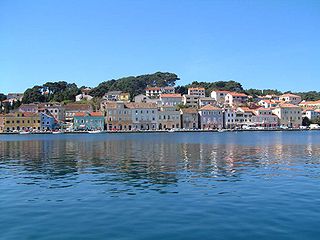
Lošinj is a Croatian island in the northern Adriatic Sea, in the Kvarner Gulf. It is almost due south of the city of Rijeka and part of the Primorje-Gorski Kotar County.

<span class="mw-page-title-main">Dugi Otok</span> Long island in the Adriatic sea, part of Croatia

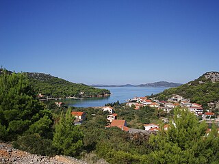
Dugi Otok is the seventh largest island in the Adriatic Sea, part of Croatia. It is located off the Dalmatian coast, west of Zadar. It is the largest and westernmost of the Zadarian Islands, and derives its name from its distinctive shape: it is 44.5 km long by 4.8 km wide, with an area of 114 square kilometres (44 sq mi). Its elevation reaches 300 m; and many of its higher portions contain stands of Maritime Pine.

<span class="mw-page-title-main">Croatian Littoral</span> Geographical region of Croatia

Croatian Littoral is a historical name for the region of Croatia comprising mostly the coastal areas between traditional Dalmatia to the south, Mountainous Croatia to the north, Istria and the Kvarner Gulf of the Adriatic Sea to the west. The term "Croatian Littoral" developed in the 18th and 19th centuries, reflecting the complex development of Croatia in historical and geographical terms.

<span class="mw-page-title-main">Vrgada</span>

Vrgada is an island off the coast of Croatia in the Adriatic Sea. It is located halfway between Zadar and Šibenik, in the archipelago northwest of Murter and south of Biograd na moru, 2.5 nautical miles (4.6 km) from the mainland. It has area of 3.7 square kilometres. and population of 249. The only settlement on the island is also named Vrgada and is surrounded with pine forest. Main industries are agriculture and fishing. On northeast coast, there are several small coves.

<span class="mw-page-title-main">Kaprije</span> Island of Croatia

Kaprije is an island in the Croatian part of the Adriatic Sea. It is situated in Šibenik archipelago. It has area of 7.11 km2 (2.75 sq mi) and population of 189, in the eponymous single settlement on the island. The island is composed of hills divided by transversal and longitudinal valleys where grass and sparse pine forests grow. Grapes and olives are cultivated there. The main industries are agriculture, fishing and tourism. Automobiles are not allowed on the island.

<span class="mw-page-title-main">Drvenik Veli</span> Island of Croatia

Drvenik Veli is an island in Croatian part of Adriatic Sea. It is situated in the middle of the Dalmatian archipelago, northwest of Šolta, 1.8 kilometres from the mainland. Its area is 12.07 square kilometres (4.66 sq mi). The highest peak is 178 metres high. The only settlement on the island is the near-eponymous village of Drvenik Veliki with a population of 150.

<span class="mw-page-title-main">Žirje, Croatia</span> Place in Šibenik-Knin County, Croatia

Žirje is an island and a settlement in the Croatian part of the Adriatic Sea. It is situated in the Šibenik archipelago, about 22 kilometres southwest of Šibenik, which makes it the most remote permanently inhabited island in the Šibenik archipelago. Its area is 15.08 km2, and it has a population of 103. Its population is steadily decreasing.

<span class="mw-page-title-main">Rava (island)</span> Island in Croatia

Rava is an island in the Croatian part of the Adriatic Sea. It is situated in the Zadar Archipelago, between Iž and Dugi Otok, 16 nautical miles (30 km) from Zadar. Its area is 3.6 km2, and it has a population of 117. The only settlements on the island are Vela Rava and Mala Rava. The coast of the island is very indented with 13 bays and 15.45 kilometres of coastline. The island is composed of dolomite. The primary industries are agriculture and fishing.

<span class="mw-page-title-main">Drvenik Mali</span> Island of Croatia

Drvenik Mali (also called Ploča by local population; is an island in Croatian part of Adriatic Sea. It is situated in middle-Dalmatian archipelago, west of Drvenik Veliki, 8 nautical miles from Trogir. Its area is 3.43 square kilometres. The only settlement on the island is the eponymous village with a population of 87. The coast is well indented and sea around the island is shallow, thus convenient for fishing. The highest peak is 79 metres high. Main industries are agriculture, fishing and tourism.

<span class="mw-page-title-main">Sestrunj</span>

Sestrunj is an island in the Croatian part of the Adriatic Sea. It is situated in Zadar Archipelago, between Ugljan, Rivanj and Dugi Otok. Its area is 15.1 square kilometres, and it has population of 48. The only settlement is also called Sestrunj and is located in the island's interior. The island is partially covered with maquis shrubland and low forests. Remains of an Illyrian fort are situated on the island. The island's main industries are agriculture and fishing.

<span class="mw-page-title-main">Biševo</span> Adriatic Sea island of Croatia

Biševo is an island in the Adriatic Sea in Croatia. It is situated in the middle of the Dalmatian archipelago, five kilometers southwest of the Island of Vis. Its area is 5.8 km2 (2.2 sq mi) and it has a population of 15.

<span class="mw-page-title-main">Vele Srakane</span>

Vele Srakane is an island in the Croatian part of Adriatic Sea. It is situated between Lošinj, Unije and Susak, just north of Male Srakane. Its area is 1.15 km2, and as of 2021, it had a population of 4, down from 8 in 2001. Administratively, it is part of the town of Mali Lošinj. Highest peak is Vela straža, 59 meters high. As of 2012 there are no cars, no shops and no running water on the island. Electricity, however, is available. There is no harbour suitable for sheltering on the island, just two concrete piers unsuitable for longer containment, and the coast contains numerous reefs. This leads the islanders to ground their boats rather than anchor them. The island has been inhabited since prehistory. On Vela Straža, there are remnants of this prehistoric settlement.

<span class="mw-page-title-main">Mrduja</span>

Mrduja is an uninhabited island in the Croatian region of Dalmatia. It is located in the Adriatic Sea, within the Split Gates between the islands of Brač and Šolta, about 400 m from Cape Zaglav near Milna. The island is nearer to Brač than to Šolta: a legend goes that the inhabitants of Brač and those of Šolta wrangled over whom the island belonged to so they used a rope in an attempt to pull it from one side of the Split Channel to the other. The people of Brač won the tug of war.

Šćedro is an island in the Adriatic Sea with an area of 8.36 km2, 2.7 kilometres (1.7 mi) off the south coast of the island of Hvar, Croatia, opposite the settlement of Zavala. The name comes from štedri, meaning charitable in old Slavonic, because the island offers two deep, well-protected coves. The Latin name of Šćedro was Tauris from which derived the Italian Tauricola or Torcola.

Jakljan is an uninhabited islet in Croatia, part of the Elaphiti Islands archipelago off the coast of southern Dalmatia. It is located northwest of Dubrovnik and west of the island of Šipan. Its area is 3.4 km2 and its coastline is 14.6 km long. A children's resort and recreational center is located on the island.

<span class="mw-page-title-main">Ošljak (island)</span> Island in Dalmatia, Croatia

Ošljak is a Croatian island in the Adriatic Sea. Its total area is 0.3 km2 and it lies just off the Dalmatian coast between Zadar and the island of Ugljan. According to the 2011 Census, the island's single village, located on the western shore and facing the towns of Kali and Preko on Ugljan, has a resident population of 29 inhabitants, and its highest point, called Lazaret, peaks at 90 m (300 ft). Ošljak used to be called Calugerà, after the noble Calogerà family that had owned the island and built its summer residence and gardens there. On the island is the church of St. Mary from the 6th century.

References

  1. 1 2 3 Croatian Bureau of Statistics (2009). "Geographical and meteorological data" (PDF). Statistical Yearbook for 2009. Croatian Bureau of Statistics. p. 44. Archived (PDF) from the original on 2017-01-03. Retrieved 2011-10-09.
  2. Faričić, Josip (23 February 2006). "Hrvatski pseudo-otoci". geografija.hr (in Croatian). Archived from the original on 10 July 2012. Retrieved 2009-02-26.
  3. 1 2 3 4 Ostroški, Ljiljana, ed. (December 2015). Statistički ljetopis Republike Hrvatske 2015 [Statistical Yearbook of the Republic of Croatia 2015](PDF). Statistical Yearbook of the Republic of Croatia (in Croatian and English). Vol. 47. Zagreb: Croatian Bureau of Statistics. p. 47. ISSN   1333-3305 . Retrieved 27 December 2015.
  4. 1 2 3 Ministry of Development and Reconstruction (February 1997). "National island development programme" (PDF). Ministry of the Sea, Transport and Infrastructure. Archived from the original (PDF) on 2011-08-07. Retrieved 2011-06-29.
  5. Treglav, Bojan (1 September 2006). "Za otoke milijardu kuna godišnje!" (PDF). Vjesnik (in Croatian). pp. 2–3. Archived from the original (PDF) on 20 March 2009. Retrieved 2006-10-02.
  6. "Povijest Hvara". hvar.hr (in Croatian). City of Hvar. Archived from the original on 2016-10-28. Retrieved 2016-10-27.
  7. Hazel, John (2000). Who's who in the Greek world. Routledge. p. 86. ISBN   0-415-12497-2.
  8. "The Islands Act (Refined Text)" (PDF). Ministry of the Sea, Transport and Infrastructure. 8 March 2006. Archived from the original (PDF) on 7 August 2011. Retrieved 2009-03-20.
  9. 1 2 "Vrgada" (in Croatian). peljar.cvs.hr. Archived from the original on 2016-03-03. Retrieved 2006-10-02.
  10. 1 2 "Otok Lopud, Dubrovnik" (in Croatian). Archived from the original on 2016-03-03. Retrieved 2006-10-02.
  11. 1 2 "Ist" (in Croatian). peljar.cvs.hr. Archived from the original on 2016-03-08. Retrieved 2006-10-02.
  12. 1 2 "The Brodarica - Krapanj Tourist Board". Archived from the original on 2006-09-08. Retrieved 2006-10-02.
  13. 1 2 "Koločep" (in Croatian). peljar.cvs.hr. Archived from the original on 2016-03-03. Retrieved 2006-10-02.
  14. 1 2 "Susak" (in Croatian). peljar.cvs.hr. Archived from the original on 2016-03-03. Retrieved 2006-10-02.
  15. 1 2 "Rava" (in Croatian). peljar.cvs.hr. Archived from the original on 2016-03-03. Retrieved 2006-10-02.
  16. 1 2 "Drvenik Mali" (in Croatian). peljar.cvs.hr. Archived from the original on 2016-03-04. Retrieved 2006-10-02.
  17. 1 2 "Ilovik" (in Croatian). peljar.cvs.hr. Archived from the original on 2016-03-04. Retrieved 2006-10-02.
  18. 1 2 "Zverinac" (in Croatian). peljar.cvs.hr. Archived from the original on 2016-03-03. Retrieved 2006-10-02.
  19. 1 2 "Rivanj" (in Croatian). peljar.cvs.hr. Archived from the original on 2016-03-07. Retrieved 2006-10-02.
  20. 1 2 "Ošljak" (in Croatian). peljar.cvs.hr. Archived from the original on 2012-03-30. Retrieved 2011-10-09.
  21. 1 2 "Biševo" (in Croatian). peljar.cvs.hr. Archived from the original on 2016-03-04. Retrieved 2006-10-02.
  22. 1 2 "Vele Srakane" (in Croatian). peljar.cvs.hr. Archived from the original on 2016-03-04. Retrieved 2006-10-02.
  23. Duplančić Leder, Tea; Ujević, Tin; Čala, Mendi (June 2004). "Coastline lengths and areas of islands in the Croatian part of the Adriatic Sea determined from the topographic maps at the scale of 1 : 25 000" (PDF). Geoadria. Zadar. 9 (1): 5–32. doi: 10.15291/geoadria.127 . Archived from the original on 2020-03-10. Retrieved 2019-11-19.
  24. "Cave Srakane". DCS Lošinj. Archived from the original on 2011-07-21. Retrieved 2010-02-10.