The Aral Sea was an endorheic lake lying between Kazakhstan in the north and Uzbekistan in the south which began shrinking in the 1960s and had largely dried up by the 2010s. The name roughly translates as "Sea of Islands", referring to over 1,100 islands that had dotted its waters. In the Mongolic and Turkic languages, aral means "island, archipelago". The Aral Sea drainage basin encompasses Uzbekistan and parts of Tajikistan, Turkmenistan, Kyrgyzstan, Kazakhstan, Afghanistan, and Iran.

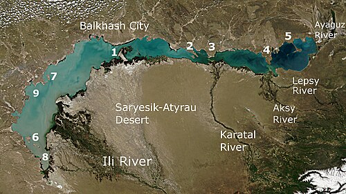
Lake Balkhash is a lake in southeastern Kazakhstan, one of the largest lakes in Asia and the 15th largest in the world. It is located in the eastern part of Central Asia and sits in the Balkhash-Alakol Basin, an endorheic (closed) basin. The basin drains seven rivers, the primary of which is the Ili, bringing most of the riparian inflow; others, such as the Karatal, bring surface and subsurface flow. The Ili is fed by precipitation, largely vernal snowmelt, from the mountains of China's Xinjiang region.

The Ili is a river situated in Northwest China and Southeastern Kazakhstan. It flows from the Ili Kazakh Autonomous Prefecture of the Xinjiang Uighur Autonomous Region to the Almaty Region in Kazakhstan.

Dike Kokaral is a 12 km long dam across a narrow stretch of the former Aral Sea, splitting off the North Aral Sea from the area that once contained the much larger South Aral Sea. The dike is conserving the dwindling waters of the Syr Darya river and maintaining the damaged ecology of the North Aral Sea, at the expense of sealing the fate of the larger South Aral. Work was completed in August 2005, with help from the World Bank. Dike Kokaral is named after the Kokaral peninsula, which would connect it to the other shore of the Aral Sea and separate the northern from the southern seas.

England comprises most of the central and southern two-thirds of the island of Great Britain, in addition to a number of small islands of which the largest is the Isle of Wight. England is bordered to the north by Scotland and to the west by Wales. It is closer to continental Europe than any other part of mainland Britain, divided from France only by a 33 km (21 mi) sea gap, the English Channel. The 50 km (31 mi) Channel Tunnel, near Folkestone, directly links England to mainland Europe. The English/French border is halfway along the tunnel.

Bismil is a district of Diyarbakır Province of Turkey. The population is 117,674 and most of the people are Kurds.

Barsa-Kelmes is a former island, the largest in the Aral Sea. Its area was 133 km2 in the 1980s, but as the sea became more shallow it steadily grew, until in the 1990s it ceased to be an island. Its highest altitude is 113 m.
Barsa-Kelmes Nature Reserve is a wildlife refuge on the former island of Barsa-Kelmes in Kyzylorda Region of Kazakhstan, in Central Asia.
The 45th parallel north is a circle of latitude that is 45 degrees north of Earth's equator. It crosses Europe, Asia, the Pacific Ocean, North America, and the Atlantic Ocean. The 45th parallel north is often called the halfway point between the equator and the North Pole, but the true halfway point is 16.0 km (9.9 mi) north of it because Earth is an oblate spheroid; that is, it bulges at the equator and is flattened at the poles.

Mangyshlak or Mangghyshlaq Peninsula is a large peninsula located in western Kazakhstan. It borders on the Caspian Sea in the west and with the Buzachi Peninsula, a marshy sub-feature of the main peninsula, in the northeast. The Tyuleniy Archipelago lies off the northern shores of the peninsula.

The Tyuleniy Archipelago, is an island group in the north-eastern Caspian Sea off the Mangyshlak Bay west of the Mangyshlak Peninsula and about 13 kilometres northwest of the Tupkaragan Peninsula, 27 kilometres north of Bautino. Perhaps the most substantial group of islands in the Caspian, they were first accurately mapped by Fedor Ivanovich Soimonov who led the 1719 Caspian Expedition, studying the Caspian Sea from 1719 to 1727.
Spirkin Oseredok Island is a low, flat island in the Caspian Sea. It is located east of the mouths of the Volga.

Durneva Island or Dūrnev Araldary is a coastal island near the entrance of the Dead Kultuk of the eastern Caspian Sea. It is located north of the Buzachi Peninsula and 41.6 km north of Turum.

Below is the list of Kazakhstan related articles.

The borders of the oceans are the limits of Earth's oceanic waters. The definition and number of oceans can vary depending on the adopted criteria. The principal divisions of the five oceans are the Pacific Ocean, Atlantic Ocean, Indian Ocean, Southern (Antarctic) Ocean, and Arctic Ocean. Smaller regions of the oceans are called seas, gulfs, bays, straits, and other terms. Geologically, an ocean is an area of oceanic crust covered by water.
The Buzachi Peninsula is a peninsula located in western Kazakhstan. It borders on the Mangyshlak Bay of the Caspian Sea in the west and with the Mangyshlak Peninsula in the southwest. The Dead Kultuk lies to the northeast and the narrow Kaydak Inlet forms its eastern limit. Durneva Island lies to the north and the Tyuleniy Archipelago lies off the western shores of the peninsula.
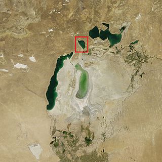
Barsakelmes Lake is a portion of water located between the Northern and Western Seas of the former unified Aral Sea. It is the last remainder of the Eastern basin of the former South Aral Sea.