Hiking is a long, vigorous walk, usually on trails or footpaths in the countryside. Walking for pleasure developed in Europe during the eighteenth century. Religious pilgrimages have existed much longer but they involve walking long distances for a spiritual purpose associated with specific religions.

The Trans Canada Trail, officially named The Great Trail between September 2016 and June 2021, is a cross-Canada system of greenways, waterways, and roadways that stretches from the Atlantic to the Pacific to the Arctic oceans. The trail extends over 24,000 km (15,000 mi); it is now the longest recreational, multi-use trail network in the world. The idea for the trail began in 1992, shortly after the Canada 125 celebrations. Since then it has been supported by donations from individuals, corporations, foundations, and all levels of government.

The GR footpaths are a network of long-distance walking trails in Europe, mostly in France, Belgium, the Netherlands, and Spain. They go by the following names: French: sentier de grande randonnée, West Flemish: Groteroutepad, Dutch: Langeafstandwandelpad, Spanish: sendero de gran recorrido, Portuguese: percurso pedestre de grande rota – generally meaning "long trail" or more literally "great route". The trails in France alone cover approximately 60,000 kilometres (37,000 mi). Trails are blazed with characteristic marks consisting of a white stripe above a red stripe. These appear regularly along the route, especially at places such as forks or crossroads.

Karakuwa was a town located in Motoyoshi District, in the extreme northeast of Miyagi Prefecture, bordering Kesennuma to the north-west and Rikuzentakata, part of Iwate Prefecture, to the north, and with Kesennuma Bay including Oshima island to the west, Hirota Bay to the north-east, and the Pacific Ocean to the south and east.

The Long Path is a 357-mile (575 km) long-distance hiking trail beginning in New York City, at the West 175th Street subway station near the George Washington Bridge and ending at Altamont, New York, in the Albany area. While not yet a continuous trail, relying on road walks in some areas, it nevertheless takes in many of the popular hiking attractions west of the Hudson River, such as the New Jersey Palisades, Harriman State Park, the Shawangunk Ridge and the Catskill Mountains. It offers hikers a diversity of environments to pass through, from suburbia and sea-level salt marshes along the Hudson to wilderness and boreal forest on Catskill summits 4,000 feet (1,220 m) in elevation.

Alta Via 1 is a 125-kilometre-long high-level public footpath which runs through the eastern Dolomites in Italy. It is also known as the Dolomite High Route 1. It passes through some of the finest scenery in the Dolomites. The path runs south from Pragser Wildsee, near Toblach, to Belluno. Prags can be accessed by bus, and Belluno has both train and bus services.

Mount Monroe is a 5,372-foot-high (1,637 m) mountain peak southwest of Mount Washington in the Presidential Range of the White Mountains in New Hampshire, United States. It is named for American President James Monroe and is the fourth highest mountain on the 4000 footers list for New Hampshire. The Appalachian Trail skirts its summit, which is the next highest peak on or near the trail north of Mount Rogers in Virginia. The Lakes of the Clouds, and its AMC hut, lie nestled at the col between Mount Monroe and neighboring Mount Washington.

GR 10 is a French GR footpath, or hiking trail, that runs the length of the Pyrenees Mountains. It roughly parallels the French–Spanish border on the French side. Those attempting the entire trail often choose to walk it from west to east, from Hendaye on the Bay of Biscay to Banyuls-sur-Mer on the Mediterranean Sea, but it can also be traversed east to west.

The East Coast Trail (ECT) is a long-distance coastal footpath located in the Canadian province of Newfoundland and Labrador. It is a developed trail over 336 kilometres (209 mi) long, creation of which began in 1994. It is made up of 25 linked wilderness paths and passes through more than 30 communities. It was named one of the best adventure destinations by National Geographic in 2012 and is extended and improved yearly.

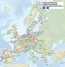
The E1 European long-distance path, or just E1 path, is one of the European long-distance paths designated by the European Ramblers' Association. It has a total length of some 7,000 kilometres (4,300 mi). It begins in Norway at Nordkapp, and crosses the Kattegat between Sweden and Denmark by ferry. It passes through Denmark, Germany, and Switzerland to finish at Capo Passero, Italy. This path was extended southwards to Sicily, in Italy, in 2018.
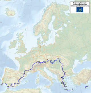
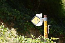
The E4 European long distance path or E4 path is one of the European long-distance paths. Starting at Tarifa Andalusia, located at the southernmost end of the Iberian Peninsula, across the Strait of Gibraltar facing Morocco, it continues through Spain, France, Switzerland, Germany, Austria, Hungary, Romania, Bulgaria and Greece to end in Cyprus. It also visits the Greek island of Crete.

The Tōkai Nature Trail is a long-distance walkway that traverses 11 prefectures and covers 1,697 kilometres (1,054 mi), running from Meiji no Mori Takao Quasi-National Park in Tokyo to Meiji no Mori Minō Quasi-National Park in Osaka Prefecture. Hiking the entire trail usually takes 40 to 50 days.
The Kantō Fureai Trail, alternately called the Capital Region Nature Trail, is a collection of hiking trails starting and ending at “Umenoki Daira” located along National Route 20 at the foothills of Mount Takao in Hachiōji, Tokyo, Japan. It circumnavigates the entire Kantō Region through Mount Takao, Okutama, Chichibu, Mount Myōgi, Mount Taihei, Mount Tsukuba, Kasumigaura, Kujūkuri Beach, Bōsō, Miura Peninsula, and Tanzawa, stretching about 1,800 km. The 160 routes are laid out to cover natural scenery and pastoral landscapes, as well as cultural and historical sites. Each course, lasting roughly 10 km, links two points accessible by public transportation but does not necessarily connect to the next route.

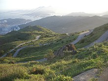
A long-distance trail is a longer recreational trail mainly through rural areas used for hiking, backpacking, cycling, horse riding or cross-country skiing. They exist on all continents except Antarctica.

The Great Himalaya Trail is a route across the Himalayas from east to west. The original concept was to establish a single long distance trekking trail from the east end to the west end of Nepal that includes a total of roughly 1,700 kilometres (1,100 mi) of path. There is a proposed trail of more than 4,500 kilometres (2,800 mi) stretching the length of the Greater Himalaya range from Nanga Parbat in Pakistan to Namche Barwa in Tibet thus passing through, India, Nepal, Bhutan and Tibet. Although an actual continuous route is currently only a concept, if completed it would be the longest and highest alpine hiking track in the world.

Jeju Olle Trail (Korean: 제주올레길) is a long-distance footpath on Jeju Island, an island off the south-west coast of South Korea. The route follows the coastline and consists of 21 connected numbered main routes, 6 sub-routes, and a short spur that connects to Jeju International Airport. On average, the routes are 16 km in length and in total amount to 437 km. The exact length and locations change over time as trails are modified or re-routed. Jeju Olle Trail was founded by ex-journalist Suh Myung-suk.

Kausar Nag or Kausarnag, is a high-altitude oligotrophic lake located at an elevation of 3,500 metres (11,500 ft) above sea level. Kausar Nag is located in the Pir Panjal mountain range in Kulgam district of Jammu and Kashmir, India. The lake is roughly 3 km (2 mi) long and .75 km (0 mi) at the widest point. The lake is the primary source of the Veshaw River, a tributary of Jhelum. This lake is considered sacred in Hinduism.
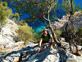
The Selvaggio Blu is a trekking route in the territory of the district of Baunei (Sardinia). It was conceived in 1987 by Mario Verin, and Peppino Cicalò (architect), President of the Nuoro section of the Italian Alpine Club. The itinerary extends for over 40 kilometers from the touristic port of Santa Maria Navarrese (Baunei) to the beach of Cala Sisine (Baunei). It takes on average 4 days to complete.

The sentier de Grande Randonnée 8, or GR 8 for short, is a long distance hiking trail on the French Atlantic coast. It is part of the Grande Randonnée network and runs from Saint-Brevin-les-Pins on the south of the Loire estuary, opposite the large port city of Saint-Nazaire and currently terminates at Sare in the Atlantic Pyrenees.

Alta via 2 is a high route located in the Italian Dolomites between Brixen (Bressanone) in the north and Croce d’Aune near Feltre in the south.