List of mountain passes of India

Last updated

This is a list of mountain passes of India. [1]

NameStateHeight (ft/m)Between/ connecting
Aghil Pass Ladakh 16,333 ft (4,978 m)In Gilgit Baltistan, passes with Xinjiang from northwest to southeast are Mintaka Pass near India-Xinjiang-Afghanistan tri-junction, Parpik Pass, Khunjerab Pass, then India-held Aghil Pass north of K2. Then in Depsang Plains in Ladakh, passes with Aksai Chin from northwest to southeast are Karakoram Pass (Qara Tagh La) and Lanak La.
Auden's Col Uttarakhand 17,552 ft (5,350 m)Gangotri III (21,590 ft) and Jogin I (21,210 ft) in Gangotri Group.
Banihal Pass Jammu and Kashmir 9,291 ft (2,832 m) Jammu & Kashmir
Bara-lacha-la Himachal Pradesh 16,400 ft (5,000 m)On Leh-Manali Highway, near Himachal-Ladakh border.
Bilafond La Ladakh 17,881 ft (5,450 m) Siachen Glacier
Bomdila Arunachal Pradesh 7,273 ft (2,217 m) Tawang & Assam
Changla Pass Ladakh 17,585 ft (5,360 m) Leh & Changthang
Chankan Pass Arunachal Pradesh 7,874 ft (2,400 m)Passes in southeastern Arunachal (Anjaw district) between India and Myanmar, from north to south are Dhipu Pass (Dipher Pass) east of Kibithu near India-Tibet-Myanmar tri-point border, Kumjawng Pass east of Krosam, Chankan Pass] east of Vijaynagar, Lekhapani Pass south of Namdapha National Park & east of Miao, Hpungan Pass, and Pangsau Pass south of Nampong on Stillwell Road.
Chanshal Pass Himachal Pradesh 14,830 ft (4,520 m)Dodra Kwar and Chirgaon (Rohru) in Shimla district.
Dehra Compass Ladakh 17,881 ft (5,450 m)Inside Aksai Chin.
Debsa Pass Himachal Pradesh 17,520 ft (5,340 m) Kullu and Spiti districts.
Dihang Pass Arunachal Pradesh 16,965 ft (5,171 m)Immediate south of Fishtail-II in Dibang Valley district.
Diphu Pass (Dipher Pass) Arunachal Pradesh 15,049 ft (4,587 m)Passes in southeastern Arunachal (Anjaw district) between India and Myanmar, from north to south are Dhipu Pass (Dipher Pass) east of Kibithu near India-Tibet-Myanmar tri-point border, Kumjawng Pass east of Krosam, Chankan Pass east of Vijaynagar, Lekhapani Pass south of Namdapha National Park & east of Miao, Hpungan Pass, and Pangsau Pass south of Nampong on Stillwell Road.
Dongkhala Sikkim 12,000 ft (3,700 m)Connects to Tibet. Within northeast Sikkim north of originating glacier of Lachung River and 100 km straight-line northwest of disputed Doklam in Bhutan.
Fotu La Ladakh 13,451 ft (4,100 m)On Srinagar-Leh highway between Staktse towards Kargil and Lamayuru towards Leh.
Goecha La Sikkim 16,207 ft (4,940 m)In Westcentral Sikkim within southern end of Khangchendzonga National Park, near India–Nepal border.
Gyong La Jammu and Kashmir 18,655 ft (5,686 m)Between NJ9842 and Bilafond La on AGPL in Siachen Glacier area.
Haldighati Pass Rajasthan 1,227.03 ft (374.00 m)Between Kumbhalgarh Fort and Udaipur.
Hpungan Pass Arunachal Pradesh 10,078 ft (3,072 m)Passes in southeastern Arunachal (Anjaw district) between India and Myanmar, from north to south are Dhipu Pass (Dipher Pass) east of Kibithu near India-Tibet-Myanmar tri-point border, Kumjawng Pass east of Krosam, Chankan Pass east of Vijaynagar, Lekhapani Pass south of Namdapha National Park & east of Miao, Hpungan Pass, and Pangsau Pass south of Nampong on Stillwell Road.
Imis La Ladakh 17,355 ft (5,290 m) Saddle on India-Tibet border between southeast Ladakh to Tibet on tri-junction of Ladakh-Tibet-Himachal. South of Chumar.
Indrahar Pass Himachal Pradesh 14,473 ft (4,411 m)near Dharamshala in westcentral Himachal on border between Kangra and Chamba districts.
Jalori Pass Himachal Pradesh10,280 ft (3,130 m)North of Shimla, half way between Shimla and Manali.
Jelep La Sikkim 14,300 ft (4,400 m)On India-China border, half way between Shillong in India and Doklam in Bhutan.
Kalindi Pass Uttarakhand 19,521 ft (5,950 m)Heavily glaciated out-of-the-way off-road pass northeast of Guptakashi and southwest of Kedarnath.
Karakoram Pass (Qara Tagh La) Ladakh 18,176 ft (5,540 m)North of Daulat Beg Oldi, connects northcentral Depsang Plains in Ladakh with Xinjiang. In Gilgit Baltistan, passes with Xinjiang from northwest to southeast are Mintaka Pass near India-Xinjiang-Afghanistan tri-junction, Parpik Pass, Khunjerab Pass, then India-held Aghil Pass north of K2. Then in Depsang Plains in Ladakh, passes with Aksai Chin from northwest to southeast are [Karakoram Pass (Qara Tagh La) and Lanak La.
Khardung La Ladakh 18,380 ft (5,600 m) Leh & Nubra, just east of Parpik Pass.
Khunjerab Pass Ladakh 17,582 ft (5,359 m)In Gilgit Baltistan, passes with Xinjiang from northwest to southeast are Mintaka Pass near India-Xinjiang-Afghanistan tri-junction, Parpik Pass, Khunjerab Pass, then India-held Aghil Pass north of K2. Then in Depsang Plains in Ladakh, passes with Xinjiang northwest to southeast are Karakoram Pass (Qara Tagh La) and Lanak La.
Kongka Pass Ladakh 16,965 ft (5,171 m)East of Gogra, on India-China LAC in Chang Chenmo Valley adjacent to the disputed Aksai Chin region.
Kumjawng Pass Arunachal Pradesh9,609 ft (2,929 m)Passes in southeastern Arunachal (Anjaw district) between India and Myanmar, from north to south are Dhipu Pass (Dipher Pass) east of Kibithu near India-Tibet-Myanmar tri-point border, Kumjawng Pass east of Krosam, Chankan Pass east of Vijaynagar, Lekhapani Pass south of Namdapha National Park & east of Miao, Hpungan Pass, and Pangsau Pass south of Nampong on Stillwell Road.
Kaldang Kildang La Ladakh 13,425 ft (4,092 m)East of Kargil, half way between Batalik and Mulbekh.
Kunzum Pass Himachal Pradesh 14,931 ft (4,551 m)Between Batal & Losar - both west of Kaza, connects Lahaul & Spiti valleys.
Lamkhaga Pass Himachal Pradesh 17,336 ft (5,284 m)
Lanak Pass Ladakh 17,933 ft (5,466 m)In Gilgit Baltistan, passes with Xinjiang from northwest to southeast are Mintaka Pass near India-Xinjiang-Afghanistan tri-junction, Parpik Pass, Khunjerab Pass, then India-held Aghil Pass north of K2. Then in Depsang Plains in Ladakh, passes with Aksai Chin from northwest to southeast are Karakoram Pass (Qara Tagh La) and Lanak La.
Lekhapani Pass Arunachal Pradesh 13,123 ft (4,000 m)Passes in southeastern Arunachal (Anjaw district) between India and Myanmar, from north to south are Dhipu Pass (Dipher Pass) east of Kibithu near India-Tibet-Myanmar tri-point border, Kumjawng Pass east of Krosam, Chankan Pass east of Vijaynagar, Lekhapani Pass south of Namdapha National Park & east of Miao, Hpungan Pass, and Pangsau Pass south of Nampong on Stillwell Road.
Lipulekh Pass Uttarakhand 17,500 ft (5,300 m)
Lungalacha La Ladakh 16,600 ft (5,100 m)
Mana Pass Uttarakhand 18,192 ft (5,545 m)
Mangsha Dhura Uttarakhand
Marsimik La Ladakh 18,314 ft (5,582 m)
Mayodia Pass Arunachal Pradesh 8,711 ft (2,655 m) [2]
Mintaka Pass Ladakh In Gilgit Baltistan, passes with Xinjiang from northwest to southeast are Mintaka Pass near India-Xinjiang-Afghanistan tri-junction, Parpik Pass, Khunjerab Pass, then India-held Aghil Pass north of K2. Then in Depsang Plains in Ladakh, passes with Aksai Chin from northwest to southeast are Karakoram Pass (Qara Tagh La) and Lanak La.
Muling La Uttarakhand 18,599 ft (5,669 m)Connects Uttarakhand to Tibet.
Nama Pass Uttarakhand

17,100 ft (5,200 m)

(Nanda Devi Biosphere Reserve)
Namika La Ladakh 12,139 ft (3,700 m)
Nathu La Sikkim 14,140 ft (4,310 m) Sikkim & Tibet
Niti Pass Uttarakhand
Palakkad Gap Kerala 750 ft (230 m) Kerala & Tamil Nadu
Pangsau Pass Arunachal Pradesh Passes in southeastern Arunachal (Anjaw district) between India and Myanmar, from north to south are Dhipu Pass (Dipher Pass) east of Kibithu near India-Tibet-Myanmar tri-point border, Kumjawng Pass east of Krosam, Chankan Pass east of Vijaynagar, Lekhapani Pass south of Namdapha National Park & east of Miao, Hpungan Pass, and [Pangsau Pass south of Nampong on Stillwell Road.
Parpik Pass Ladakh In Gilgit Baltistan, passes with Xinjiang from northwest to southeast are Mintaka Pass near India-Xinjiang-Afghanistan tri-junction, Parpik Pass, Khunjerab Pass, then India-held Aghil Pass north of K2. Then in Depsang Plains in Ladakh, passes with Aksai Chin from northwest to southeast are Karakoram Pass (Qara Tagh La) and Lanak La.
Pensi La Ladakh
Pir-Panjal Pass Jammu and Kashmir
Rezang La Ladakh
Rohtang Pass Himachal Pradesh 13,051 ft (3,978 m) Manali & Lahaul
Sasser Pass Ladakh 17,753 ft (5,411 m) Nubra & Siachen Glacier
Sela Pass Arunachal Pradesh 13,700 ft (4,200 m) Dirang & Tawang
Sengottai Kerala 690 ft (210 m) Travancore & Tamil Nadu
Shashi La Ladakh 13,989 ft (4,264 m)
Shingo La Ladakh
Shipki La Himachal Pradesh 12,900 ft (3,900 m)
Sia La Ladakh 18,337 ft (5,589 m) Siachen Glacier
Sin La Uttarakhand

18,028 ft (5,495 m)

Spangur Gap Ladakh
Tanglang La (Thang La) Ladakh 17,583 ft (5,359 m)
Thamarassery Kerala 1,700 ft (520 m) Malabar & Mysore
Traill's Pass Uttarakhand 17,100 ft (5,200 m)
Umling La Ladakh 19,300 ft (5,900 m)
Yonggyap Pass Arunachal Pradesh
Zojila Pass Ladakh 12,400 ft (3,800 m) Kashmir & Ladakh

See also

Related Research Articles

<span class="mw-page-title-main">Hindu Kush</span> Mountain range near the border of Afghanistan and Pakistan

The Hindu Kush is an 800-kilometre-long (500 mi) mountain range on the Iranian Plateau in Central and South Asia to the west of the Himalayas. It stretches from central and eastern Afghanistan into northwestern Pakistan and far southeastern Tajikistan. The range forms the western section of the Hindu Kush Himalayan Region (HKH); to the north, near its northeastern end, the Hindu Kush buttresses the Pamir Mountains near the point where the borders of China, Pakistan and Afghanistan meet, after which it runs southwest through Pakistan and into Afghanistan near their border.

<span class="mw-page-title-main">Karakoram</span> Major mountain range spanning the borders between India Pakistan and China

The Karakoram is a mountain range in the Kashmir region spanning the border of Pakistan, China, and India, with the northwestern extremity of the range extending to Afghanistan and Tajikistan. Most of the Karakoram mountain range falls under the jurisdiction of Gilgit-Baltistan, which is administered by Pakistan. Its highest peak, K2, is located in Gilgit-Baltistan. It begins in the Wakhan Corridor (Afghanistan) in the west, encompasses the majority of Gilgit-Baltistan, and extends into Ladakh and Aksai Chin.

<span class="mw-page-title-main">Mountain pass</span> Route through a mountain range or over a ridge

A mountain pass is a navigable route through a mountain range or over a ridge. Since mountain ranges can present formidable barriers to travel, passes have played a key role in trade, war, and both human and animal migration throughout history. At lower elevations it may be called a hill pass. A mountain pass is typically formed between two volcanic peaks or created by erosion from water or wind.

<span class="mw-page-title-main">Mount Kailash</span> Religious mountain in Tibet Autonomous Region

Mount Kailash is a mountain in Ngari Prefecture, Tibet Autonomous Region of China. It lies in the Kailash Range of the Transhimalaya, in the western part of the Tibetan Plateau. The peak of Mount Kailash is located at an elevation of 6,638 m (21,778 ft), north of the western trijunction of the border between China, India and Nepal.

<span class="mw-page-title-main">Trans-Karakoram Tract</span> Chinese-administered area in the northern half of Kashmir near the Shaksgam River

The Trans-Karakoram Tract, also known as the Shaksgam Tract, is a disputed area of approximately 5,200 km2 (2,000 sq mi) north of the Karakoram watershed, including the Shaksgam valley. The tract is administered by China as part of its Taxkorgan and Yecheng counties in the Xinjiang Uyghur Autonomous Region. Although the Shaksgam tract was under the control of Pakistan since 1947, in the 1963 Sino-Pakistan Agreement, Pakistan recognized Chinese sovereignty over the Shaksgam tract, and a border based on actual ground positions was recognized as the international border by China and Pakistan. The Shaksgam Tract, along with the entire Kashmir region, is claimed by India.

<span class="mw-page-title-main">Chang La</span> Mountain pass in Ladakh, India

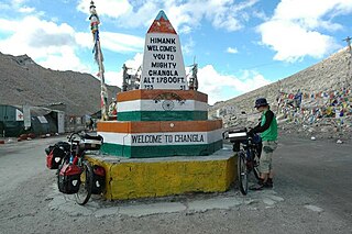
Chang La is a high mountain pass in Ladakh at an elevation of 5,391.3024 m or 17,688.000 ft in the Ladakh Range between Leh and the Shyok River valley. The Chang La, on Leh to Pangong Lake road, lies on the Leh-Karu-Sakti-Zingral-Chang La-Durbuk-Tangtse-Pangong Lake motorable road. Karu, which lies on Leh-Manali NH-3, connects Chang La and Pangong Lake to Leh and the rest of India. In September 2021, BRO opened another alternate motorable asphalt road between Zingral and Tangtse via Ke La pass and Taruk.

<span class="mw-page-title-main">Karakoram Pass</span> Mountain pass between India and China

The Karakoram Pass is a 5,540 m or 18,176 ft mountain pass between India and China in the Karakoram Range. It is the highest pass on the ancient caravan route between Leh in Ladakh and Yarkand in the Tarim Basin. 'Karakoram' literally means 'Black Gravel' in Mongolic.

<span class="mw-page-title-main">Saltoro Mountains</span> Subrange of the Karakoram located on the southwestern side of the Siachen Glacier in Kashmir

The Saltoro Mountains form a subrange within the Karakoram Range and are situated in the southeastern part of the Karakoram. They lie on the southwest side of the Siachen Glacier, which is one of the two longest glaciers in the world outside the polar regions. The name "Saltoro" is also associated with the Saltoro Valley, located west of this range and descending on the Pakistani side of the Saltoro Range, which generally follows the Actual Ground Position Line (AGPL).

<span class="mw-page-title-main">Lungalacha La</span> Mountain pass in Ladakh

Lachulung La, or Lāchālūng La or Lungalacha La, is a paved motorable mountain pass in Ladakh in India just north of border with Himachal Pradesh. It is located on the NH3 Leh–Manali Highway, 54 km (34 mi) north of Sarchu and 24 km (15 mi) west of Pang. Rail-cum-road tunnel is being constructed under this pass to cater for the traffic for existing NH3 & under-construction Bhanupli–Leh line, Bara-lacha la and Taglang La are other tunnels being constructed on this route.

<span class="mw-page-title-main">Taglang La</span> Mountain pass in Ladakh

Taglang La or Tanglang La, elevation 5,328 metres (17,480 ft), is a high altitude mountain pass in the Indian union territory of Ladakh. It is located on the NH3 Leh–Manali Highway. Rail-cum-road tunnels are being constructed under the Taglang La, Lungalacha La and Bara-lacha la to cater for the traffic from existing NH3 & under-construction Bhanupli–Leh line.

<span class="mw-page-title-main">Bilafond La</span> Mountain pass, Pakistan

Bilafond La (meaning "Pass of the Butterflies" in Balti language, also known as the Saltoro Pass, is a mountain pass situated on Saltoro Ridge, sitting immediately west of the vast Siachen Glacier, some 40 km directly north of map point NJ 980420 which defined the end of the 1972 Line of Control between Pakistan and India as part of the Simla Agreement. Bilafond La is on the ancient Silk Route linking the Indian Subcontinent and China.

<span class="mw-page-title-main">Sia La</span> Mountain pass in Ladakh

Sia La is a mountain pass situated on Saltoro Ridge, in Ladakh, India, some 60 km (37 mi) north-northwest of map point NJ9842 which defined the end of the 1972 Line of Control between India and Pakistan as part of the Simla Agreement. Sia La sits near the Chinese border and immediately northwest of the upper part of the vast Siachen Glacier, connecting that glacier to the Pakistani-controlled Kondus Glacier and valley to the west.

<span class="mw-page-title-main">Khyber Pass</span> Historically significant mountain pass in present-day Pakistan

The Khyber Pass is a mountain pass in the Khyber Pakhtunkhwa province of Pakistan, on the border with the Nangarhar Province of Afghanistan. It connects the town of Landi Kotal to the Valley of Peshawar at Jamrud by traversing part of the White Mountains. Since it was part of the ancient Silk Road, it has been a vital trade route between Central Asia and the Indian subcontinent and a strategic military choke point for various states that controlled it. The Khyber Pass is considered one of the most famous mountain passes in the world.

Indira Col West is a mountain pass at 5,988 metres (19,646 ft)) altitude on the Indira Ridge of Siachen Muztagh in Karakoram Range. It is on the border between Indian-controlled Siachen Glacier and the Chinese-controlled Trans-Karakoram Tract, close to the tripoint of India, Pakistan, and China. The India-Pakistan Actual Ground Position Line (AGPL) in the Siachen area ends near the pass. It is possible to ascend the pass from both the north and south sides controlled by China and India respectively.

<span class="mw-page-title-main">National Highway 1 (India)</span> National highway in India

National Highway 1 in India runs between the union territories of Jammu & Kashmir and Ladakh. It comprises parts of old NH1A and NH1D. The number 1 indicates, under the new numbering system, that it is the northernmost East-West highway in India.

<span class="mw-page-title-main">National Highway 3 (India)</span> National Highway in India

National Highway 3, or NH 3, is a national highway in India. It starts from Atari adjacent to India-Pakistan border and near Amritsar and terminates at Leh in Ladakh, via Manali in Himachal Pradesh.

<span class="mw-page-title-main">Umling La</span> Mountain pass in Ladakh, India

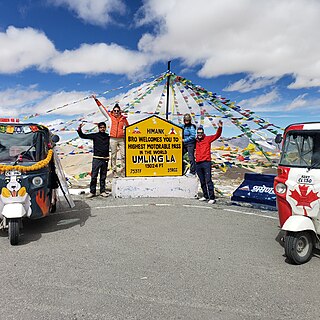
Umling La or Umlung La is the highest paved road and mountain pass in the world, located in Ladakh, India on the ridgeline between Koyul Lungpa and the Indus River near Demchok. At an elevation of 5,882.64 metres (19,300.0 ft), it forms the source for the Umlung stream that drains into the Indus and a tributary of the Kiungdul river that drains into Koyul Lungpa.

References

  1. Ramanan, Vrinda J. (21 December 2017). "Doorway of the gods: Himalaya crosses five countries". The Hindu.
  2. "Official website of District Administration - Places of interest".