List of mountains in Nepal

Last updated

Nepal contains most of the Himalayas, the highest mountain range in the world. Eight of the fourteen eight-thousanders are located in the country, either in whole or shared across a border with China or India. Nepal has the highest mountain in the world, Mount Everest at an astonishing height of 8848m as well as 1,310 peaks over 6,000 m height.

Contents

Mountains

Mountain/PeakmetresfeetSectionNotesCoordinates
Mount Everest 8,848.8629,032 Khumbu Mahalangur   Earth's highest from sea level 27°59′17″N86°55′30″E / 27.98806°N 86.92500°E / 27.98806; 86.92500 (Mount Everest (8848.86 m))
Kanchenjunga 8,58628,169Northern Kanchenjunga  3rd highest on Earth 27°42′0.00″N88°7′59.99″E / 27.7000000°N 88.1333306°E / 27.7000000; 88.1333306 (Kanchenjunga (8586 m))
Lhotse 8,51627,940Everest Group  4th highest 27°57′42″N86°56′0″E / 27.96167°N 86.93333°E / 27.96167; 86.93333 (Lhotse (8516 m))
Makalu 8,48527,838Makalu Mahalangur  5th highest 27°53′21″N87°5′19″E / 27.88917°N 87.08861°E / 27.88917; 87.08861 (Makalu (8485 m))
Cho Oyu 8,20126,906Khumbu Mahalangur  6th highest 28°5′39″N86°39′39″E / 28.09417°N 86.66083°E / 28.09417; 86.66083 (Cho Oyu (8188 m))
Dhaulagiri I 8,16726,795Dhaulagiri  7th highest 28°41′48″N83°29′24″E / 28.69667°N 83.49000°E / 28.69667; 83.49000 (Dhaulagiri (8167 m))
Manaslu 8,16326,781 Mansiri   8th highest 28°33′0″N84°33′35″E / 28.55000°N 84.55972°E / 28.55000; 84.55972 (Manaslu (8163 m))
Annapurna I 8,09126,545Annapurna  10th highest 28°35′46″N83°49′26″E / 28.59611°N 83.82389°E / 28.59611; 83.82389 (Annapurna I (8091 m))
Annapurna I Middle Peak 8,05126,414Annapurna   28°36′N83°50′E / 28.600°N 83.833°E / 28.600; 83.833 (Annapurna I Middle (8051 m))
Gyachung Kang 7,95226,089Khumbu Mahalangur  between Everest and Cho Oyu 28°5′53″N86°44′32″E / 28.09806°N 86.74222°E / 28.09806; 86.74222 (Gyachung Kang (7952 m))
Annapurna II 7,93726,040Annapurna   28°32′17.2″N84°8′6.0″E / 28.538111°N 84.135000°E / 28.538111; 84.135000 (Annapurna II (7937 m))
Himalchuli 7,89325,896Mansiri  18th highest 28°26′10″N84°38′22″E / 28.43611°N 84.63944°E / 28.43611; 84.63944 (Himalchuli (7893 m))
Ngadi Chuli 7,87125,823Mansiri  First ascent 1970 28°30′12″N84°33′59″E / 28.50333°N 84.56639°E / 28.50333; 84.56639 (Ngadi Chuli (7871 m))
Nuptse 7,86125,791Everest Group  319 metres prominence from Lhotse 27°57′59″N86°53′24″E / 27.96639°N 86.89000°E / 27.96639; 86.89000 (Nuptse (7861 m))
Dhaulagiri II 7,75125,430Dhaulagiri    28°45′48″N83°23′18″E / 28.76333°N 83.38833°E / 28.76333; 83.38833 (Dhaulagiri II (7751 m))
Jannu 7,71125,299Kumbhakarna Kangchenjunga   27°40′0″N88°2′0″E / 27.66667°N 88.03333°E / 27.66667; 88.03333 (Jannu (7711 m))
Dhaulagiri IV 7,66125,135Dhaulagiri    28°44′8.70″N83°18′53.21″E / 28.7357500°N 83.3147806°E / 28.7357500; 83.3147806 (Dhaulagiri IV (7661 m))
Dhaulagiri V 7,61824,993Dhaulagiri    28°44′2.47″N83°21′43.45″E / 28.7340194°N 83.3620694°E / 28.7340194; 83.3620694 (Dhaulagiri V (7618 m))
Annapurna III 7,55524,787Annapurna   28°35′7″N83°59′24″E / 28.58528°N 83.99000°E / 28.58528; 83.99000 (Annapurna III (7555 m))
Jongsong Peak 7,46224,482Janak  #57 in the world 27°52′53″N88°8′9″E / 27.88139°N 88.13583°E / 27.88139; 88.13583 (Jongsong Peak (7462 m))
Gangapurna 7,45524,459Annapurna   28°36′17″N83°57′51″E / 28.60472°N 83.96417°E / 28.60472; 83.96417 (Gangapurna (7455 m))
Yangra 7,42224,350 Ganesh    28°23′30″N85°7′38″E / 28.39167°N 85.12722°E / 28.39167; 85.12722 (Yangra (7422 m))
Kabru 7,41224,318Singalila Kangchenjunga   27°38′6″N88°7′6″E / 27.63500°N 88.11833°E / 27.63500; 88.11833 (Kabru (7412 m))
Churen Himal 7,38524,229Dhaulagiri    28°43′53.742″N83°12′36.396″E / 28.73159500°N 83.21011000°E / 28.73159500; 83.21011000 (Churen Himal (7371 m))
Kirat Chuli 7,36524,163Kangchenjunga   27°47′13″N88°11′40″E / 27.78694°N 88.19444°E / 27.78694; 88.19444 (Kirat Chuli (7365 m))
Nangpai Gosum 7,35024,114Khumbu Mahalangur  First ascent October 12, 1986. 28°4′20″N86°36′52″E / 28.07222°N 86.61444°E / 28.07222; 86.61444 (Nangpai Gosum (7350 m))
Gimmigela Chuli 7,35024,114   First ascent 1995 27°43′48″N88°9′0″E / 27.73000°N 88.15000°E / 27.73000; 88.15000 (Gimmigela Chuli (7350 m))
Chamlang 7,32124,019Barun Mahalangur  #79 in the world 27°46′33″N86°58′48″E / 27.77583°N 86.98000°E / 27.77583; 86.98000 (Chamlang (7319 m))
Dhaulagiri VI 7,26823,845Dhaulagiri   {{WikidataCoord}} – malformed coordinate data
Putha Hiunchuli 7,24623,773Dhaulagiri    28°44′51″N83°8′45″E / 28.74750°N 83.14583°E / 28.74750; 83.14583 (Putha Hiunchuli (7246 m))
Langtang Lirung 7,22723,711 Langtang   #99 in the world 28°15′22″N85°31′10″E / 28.25611°N 85.51944°E / 28.25611; 85.51944 (Langtang Lirung (7227 m))
Annapurna Dakshin 7,21923,684Annapurna   28°31′4.8″N83°48′21.6″E / 28.518000°N 83.806000°E / 28.518000; 83.806000 (Annapurna South (7219 m))
Langtang Ri 7,20523,638 Langtang   #106 in the world 28°23′N85°40′E / 28.383°N 85.667°E / 28.383; 85.667 (Langtang Ri (7205 m))
Chamar 7,18723,579 Sringi   First ascent 1953 28°33′19″N84°56′43″E / 28.55528°N 84.94528°E / 28.55528; 84.94528 (Chamar (7165 m))
Melungtse 7,18123,560Rolwaling  First ascent 1988 27°58′16″N86°26′15″E / 27.97111°N 86.43750°E / 27.97111; 86.43750 (Melungtse (7181 m))
Pumori 7,16123,494Khumbu Mahalangur  First ascent 1962 28°0′52.999″N86°49′41.002″E / 28.01472194°N 86.82805611°E / 28.01472194; 86.82805611 (Pumori (7161 m))
Nemjung Manang7,14023,425   First ascent 1983 28°44′6″N84°25′0″E / 28.73500°N 84.41667°E / 28.73500; 84.41667 (Nemjung (7140 m))
Gaurishankar 7,13423,406Rolwaling  First ascent 1979 27°57′12″N86°20′9″E / 27.95333°N 86.33583°E / 27.95333; 86.33583 (Gauri Sankar (7134 m))
Tilicho Peak 7,13423,406Annapurna  First ascent 1979 28°41′4″N83°48′16″E / 28.68444°N 83.80444°E / 28.68444; 83.80444 (Tilicho Peak (7134 m))
Api 7,13223,399Yoka Pahar Gurans   First ascent 1960 30°0′19″N80°55′47″E / 30.00528°N 80.92972°E / 30.00528; 80.92972 (Api (7132 m))
Baruntse 7,12923,389Barun Mahalangur  First ascent 1954 27°53′N86°59′E / 27.883°N 86.983°E / 27.883; 86.983 (Baruntse (7129 m))
Machapuchare 6,99322,943Annapurna  Sacred mountain, unclimbed 28°29′42″N83°56′57″E / 28.49500°N 83.94917°E / 28.49500; 83.94917 (Machhapuchhre (6997 m))
Kang Guru 6,98122,904Larkya or Peri  2005 avalanche kills 18 28°39′27″N84°18′5″E / 28.65750°N 84.30139°E / 28.65750; 84.30139 (Kang Guru (6981 m))
Dorje Lakpa 6,96622,854Langtang   28°10′26″N85°46′45″E / 28.17389°N 85.77917°E / 28.17389; 85.77917 (Dorje Lhakpa (6966 m))
Numbur 6,95822,828Rolwaling  First ascent 1981 27°45′16.006″N86°34′23.066″E / 27.75444611°N 86.57307389°E / 27.75444611; 86.57307389 (Numburchuili (6958 m))
Lugula Himal 6,88922,602 Gandaki Province   First ascent 2014 28°53′47.519″N84°15′35.734″E / 28.89653306°N 84.25992611°E / 28.89653306; 84.25992611 (Lugula Himal (6889 m))
Kanjiroba 6,88322,582 Kanjiroba Himal    29°23′N82°41′E / 29.383°N 82.683°E / 29.383; 82.683 (Kanjiroba (6883 m))
Chumbu 6,85922,503Khumbu Mahalangur  First ascent November 3, 2022 28°0′50.159″N86°47′18.290″E / 28.01393306°N 86.78841389°E / 28.01393306; 86.78841389 (Chumbu (6853 m))
Kubi Gangri 6,85922,503Himalayas   29°45′57.791″N82°45′5.868″E / 29.76605306°N 82.75163000°E / 29.76605306; 82.75163000 (Kubi Gangri (6859 m))
Jethi Bahurani 6,85022,474Himalayas   29°50′N81°1′E / 29.833°N 81.017°E / 29.833; 81.017 (Jethi Bahurani (6850 m))
Ama Dablam 6,81222,349Barun Mahalangur  "Mother and her necklace" 27°51′40″N86°51′41″E / 27.86111°N 86.86139°E / 27.86111; 86.86139 (Ama Dablam (6814 m))
Kangtega 6,78222,251Barun Mahalangur  First ascent 1963 27°47′0″N86°49′0″E / 27.78333°N 86.81667°E / 27.78333; 86.81667 (Kangtega (6783 m))
Cho Polu 6,73522,096Barun Mahalangur  First ascent 1999 27°55′9″N86°58′55″E / 27.91917°N 86.98194°E / 27.91917; 86.98194 (Cho Polu (6735 m))
Kang Nachugo 6,73522,096 Joe Puryear, David Gottlieb  First ascent 2008 27°54′21.730″N86°26′32.845″E / 27.90603611°N 86.44245694°E / 27.90603611; 86.44245694 (Kang Nachugo (6735 m))
Changla 6,72122,051Himalayas   30°7′N82°10′E / 30.117°N 82.167°E / 30.117; 82.167 (Changla (6563 m))
Lingtren 6,71422,028Khumbu Mahalangur  First ascent 1935 28°1′38.93″N86°51′18.90″E / 28.0274806°N 86.8552500°E / 28.0274806; 86.8552500 (Lingtren (6714 m))
Num Ri 6,67721,906Barun Mahalangur  First ascent 2002 27°53′40.99″N86°58′14.99″E / 27.8947194°N 86.9708306°E / 27.8947194; 86.9708306 (Num Ri (6677 m))
Khumbutse 6,64021,785Khumbu Mahalangur  First mountain west of Everest 28°1′13″N86°52′23″E / 28.02028°N 86.87306°E / 28.02028; 86.87306 (Khumbutse (6636 m))
Thamserku 6,62321,729Barun Mahalangur  First ascent 1964 27°47′25″N86°47′15″E / 27.79028°N 86.78750°E / 27.79028; 86.78750 (Thamserku (6623 m))
Pangboche 6,62021,719Kutang Himal  {{WikidataCoord}} – malformed coordinate data
Dragmarpo Ri 6,57821,581Langtang  Unclimbed 28°19′32.5″N85°39′41.0″E / 28.325694°N 85.661389°E / 28.325694; 85.661389 (Dragmarpo Ri (6578 m))
Taboche 6,54221,463Khumbu Mahalangur  First ascent 1974 27°53′48″N86°46′39″E / 27.89667°N 86.77750°E / 27.89667; 86.77750 (Taboche (6501 m))
Singu Chuli 6,50121,329Annapurna   Trekking peak 28°35′N83°54′E / 28.583°N 83.900°E / 28.583; 83.900 (Singu Chuli (6501 m))
Mera Peak 6,47621,247Himalayas  Trekking peak 27°42′0″N86°52′0″E / 27.70000°N 86.86667°E / 27.70000; 86.86667 (Mera Peak (6476 m))
Hiunchuli 6,44121,132Annapurna  Trekking peak (difficult) 28°31′N83°53′E / 28.517°N 83.883°E / 28.517; 83.883 (Hiunchuli (6441 m))
Cholatse 6,44021,129Khumbu Mahalangur  Connected to Taboche 27°55′5″N86°46′0″E / 27.91806°N 86.76667°E / 27.91806; 86.76667 (Cholatse (6440 m))
Kusum Kangguru 6,36720,889Barun Mahalangur  Trekking peak (difficult) 27°43′50″N86°47′27″E / 27.73056°N 86.79083°E / 27.73056; 86.79083 (Kusum Kanguru (6367 m))
Ombigaichan 6,34020,801Barun Mahalangur   27°51′10.138″N86°53′0.370″E / 27.85281611°N 86.88343611°E / 27.85281611; 86.88343611 (Ombigaichan (6340 m))
Om Parvat 6,19120,312Himalayas  Sacred summit 30°11′55.7″N81°2′4.9″E / 30.198806°N 81.034694°E / 30.198806; 81.034694 (Om Parvat (6191 m))
Kongde Ri 6,18720,299Barun Mahalangur  Trekking peak (difficult) 27°47′35.4955″N86°38′35.3242″E / 27.793193194°N 86.643145611°E / 27.793193194; 86.643145611 (Kongde Ri (6187 m))
Imja Tse 6,16020,210Khumbu Mahalangur  Also known as Island Peak. Popular trekking peak. 27°55′30.32″N86°56′15.47″E / 27.9250889°N 86.9376306°E / 27.9250889; 86.9376306 (Imja Tse (6189 m))
Lobuche 6,14520,161Khumbu Mahalangur  Trekking peak 27°57′34″N86°47′24″E / 27.95944°N 86.79000°E / 27.95944; 86.79000 (Lobuche (6145 m))
Pisang Peak 6,09119,984Annapurna  Trekking peak 28°38′49.96″N84°11′4.34″E / 28.6472111°N 84.1845389°E / 28.6472111; 84.1845389 (Pisang Peak (6091 m))
Nirekha 6,06919,911Khumbu Mahalangur  Trekking peak (difficult) 27°58′38.921″N86°45′45.731″E / 27.97747806°N 86.76270306°E / 27.97747806; 86.76270306 (Nirekha (6169 m))
Baden-Powell Peak 5,82519,111Jugal  Formerly known as Urkema Peak 28°10′3.25″N85°32′0.13″E / 28.1675694°N 85.5333694°E / 28.1675694; 85.5333694 (Baden-Powell Peak (5710 m))
Pokalde 5,80619,049Khumbu Mahalangur  Trekking peak (moderate) 27°55′30″N86°50′0″E / 27.92500°N 86.83333°E / 27.92500; 86.83333 (Pokalde (5806 m))
Mount Khumbila 5,76118,901Mahalangur  Unclimbed 27°51′2″N86°42′0″E / 27.85056°N 86.70000°E / 27.85056; 86.70000 (Mount Khumbila (5761 m))
Tharpu Chuli 5,66318,579Annapurna  Trekking peak 28°33′43.81″N83°53′22.81″E / 28.5621694°N 83.8896694°E / 28.5621694; 83.8896694 (Tharpu Chuli (5663 m))
Kala Patthar 5,54518,192Khumbu Mah  Popular hiking peak below Pumori 28°0′N86°50′E / 28.000°N 86.833°E / 28.000; 86.833 (Kala Patthar (5645 m))
Yala Peak 5,52018,110Langtang   28°13′43″N85°37′41″E / 28.22861°N 85.62806°E / 28.22861; 85.62806 (Yala Peak (5732 m))
Gokyo Ri 5,35717,575Himalayas  Popular hiking peak 27°57′40″N86°41′0″E / 27.96111°N 86.68333°E / 27.96111; 86.68333 (Gokyo Ri (5357 m))

Other ranges

North of the Greater Himalayas in western Nepal, ~6,100 metre Tibetan Border Ranges form the Ganges-Brahmaputra divide, which the international border generally follows. South of the Greater Himalayas, Nepal has a High Mountain region of ~4,000 metre summits, then the Middle Hills and Mahabharat Range with 1,500 to 3,000 metre summits. South of the Mahabharats, an outer range of foothills with ~1,000 metre summits is called the Siwaliks or Churiya Hills.

See also

Related Research Articles

<span class="mw-page-title-main">K2</span> 2nd-highest mountain on Earth

K2, at 8,611 metres (28,251 ft) above sea level, is the second-highest mountain on Earth, after Mount Everest at 8,849 metres (29,032 ft). It lies in the Karakoram range, partially in the Gilgit-Baltistan region of Pakistan-administered Kashmir and partially in the China-administered Trans-Karakoram Tract in the Taxkorgan Tajik Autonomous County of Xinjiang.

<span class="mw-page-title-main">Mount Everest</span> Earths highest mountain

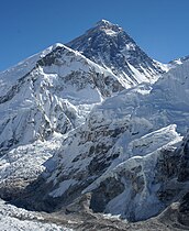
Mount Everest is Earth's highest mountain above sea level, located in the Mahalangur Himal sub-range of the Himalayas. The China–Nepal border runs across its summit point. Its elevation of 8,848.86 m was most recently established in 2020 by the Chinese and Nepali authorities.

The Seven Summits are the highest mountains on each of the seven traditional continents. On 30 April 1985, Richard Bass became the first climber to reach the summit of all seven.

<span class="mw-page-title-main">Presidential Range</span> Mountain range in the White Mountains of New Hampshire, US

The Presidential Range is a mountain range located in the White Mountains of the U.S. state of New Hampshire. Containing the highest peaks of the Whites, its most notable summits are named for American presidents, followed by prominent public figures of the 18th and 19th centuries. The Presidential Range is notorious for having some of the worst weather on Earth, mainly because of the unpredictability of high wind speeds and whiteout conditions on the higher summits. Because of the poor weather conditions, the Presidential Range is often used for mountaineering training for those who go on to climb some of the world's highest mountains, including K2 and Everest.

<span class="mw-page-title-main">Cho Oyu</span> 6th-highest mountain on Earth, located in Nepal and China

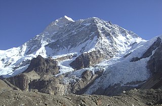
Cho Oyu is the sixth-highest mountain in the world at 8,188 metres (26,864 ft) above sea level. Cho Oyu means "Turquoise Goddess" in Tibetan. The mountain is the westernmost major peak of the Khumbu sub-section of the Mahalangur Himalaya 20 km west of Mount Everest. The mountain stands on the China Tibet–Nepal Koshi Pradesh border.

<span class="mw-page-title-main">Eight-thousander</span> Mountain peaks of over 8,000 m

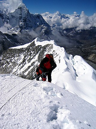
The eight-thousanders are the 14 mountains recognised by the International Mountaineering and Climbing Federation (UIAA) as being more than 8,000 metres (26,247 ft) in height above sea level, and sufficiently independent of neighbouring peaks. There is no precise definition of the criteria used to assess independence, and at times, the UIAA has considered whether the list should be expanded to 20 mountain peaks by including the major satellite peaks of eight-thousanders. All of the eight-thousanders are located in the Himalayan and Karakoram mountain ranges in Asia, and their summits lie in an altitude known as the death zone.

<span class="mw-page-title-main">Dhaulagiri</span> Eight-thousander and 7th-highest mountain on Earth, located in Nepal

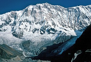
Dhaulagiri, located in Nepal, is the seventh highest mountain in the world at 8,167 metres (26,795 ft) above sea level, and the highest mountain within the borders of a single country. It was first climbed on 13 May 1960 by a Swiss-Austrian-Nepali expedition. Annapurna I is 34 km (21 mi) east of Dhaulagiri. The Kali Gandaki River flows between the two in the Kaligandaki Gorge, said to be the world's deepest. The town of Pokhara is south of the Annapurnas, an important regional center and the gateway for climbers and trekkers visiting both ranges as well as a tourist destination in its own right.

<span class="mw-page-title-main">Summit</span> Point on a surface with a higher elevation than all immediately adjacent points

A summit is a point on a surface that is higher in elevation than all points immediately adjacent to it. The topographic terms acme, apex, peak, and zenith are synonymous.

<span class="mw-page-title-main">Ultra-prominent peak</span> Mountain with prominence of 1,500 metres

An ultra-prominent peak, or ultra for short, is a mountain summit with a topographic prominence of 1,500 metres (4,900 ft) or more; it is also called a P1500. The prominence of a peak is the minimum height of climb to the summit on any route from a higher peak, or from sea level if there is no higher peak. There are approximately 1,524 such peaks on Earth. Some well-known peaks, such as the Matterhorn and Eiger, are not ultras because they are connected to higher mountains by high cols and thus do not achieve enough topographic prominence.

In the history of mountaineering, the world altitude record referred to the highest point on the Earth's surface which had been reached, regardless of whether that point was an actual summit. The world summit record referred to the highest mountain to have been successfully climbed. The terms are most commonly used in relation to the history of mountaineering in the Himalaya and Karakoram ranges, though modern evidence suggests that it was not until the 20th century that mountaineers in the Himalaya exceeded the heights which had been reached in the Andes. The altitude and summit records rose steadily during the early 20th century until 1953, when the ascent of Mount Everest made the concept obsolete.

References

    [1]

    1. "Top 10 Highest Mountains in Nepal | Top Nepali". 2 August 2023.