Related Research Articles
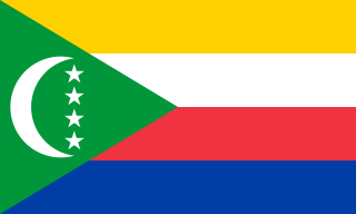
The Comoros, officially the Union of the Comoros, is an archipelagic country in the Indian Ocean, at the northern end of the Mozambique Channel off the eastern coast of Africa. It shares maritime borders with Madagascar and Mayotte to the southeast, Tanzania to the northwest, Mozambique to the west, and the Seychelles to the northeast. Its capital and largest city is Moroni. The religion of the majority of the population, and the official state religion, is Sunni Islam. As a member of the Arab League, it is the only country in the Arab world which is entirely in the Southern Hemisphere. It is also a member state of the African Union, the Organisation internationale de la Francophonie, the Organisation of Islamic Cooperation, and the Indian Ocean Commission. The country has three official languages: Comorian, French and Arabic.

The Glorieuses or Glorioso Islands are a group of French islands and rocks totaling 5 square kilometres. They are controlled by France as part of the Scattered Islands in the Indian Ocean in the French Southern and Antarctic Lands, a French overseas territory, but are also claimed by Comoros, Madagascar and formerly by Seychelles. They are geographically part of the Comoro Islands between the French overseas region of Mayotte and the nation of Madagascar.
Mayotte is an overseas department and region and single territorial collectivity of France officially named the Department of Mayotte. It is located in the northern part of the Mozambique Channel in the Indian Ocean off the coast of Southeastern Africa, between Northwestern Madagascar and Northeastern Mozambique. Mayotte consists of a main island, Grande-Terre, a smaller island, Petite-Terre, as well as several islets around these two. Mayotte is the most prosperous territory in the Mozambique Channel, making it a major destination for illegal immigration.

Anjouan is an autonomous high island in the Indian Ocean that forms part of the Union of the Comoros. Its chief town is Mutsamudu and, as of 2006, its population is around 277,500. The total area of the island is 424 square kilometers.
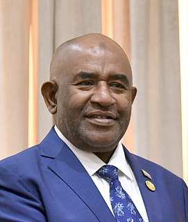
Azali Assoumani is a Comorian politician and military officer who has served as President of the Comoros since April 2019. He was also president from 2002 to 2006 and 2016 to February 2019. He became head of state after staging a coup d'état in 1999 and was elected president in 2002, 2016 and April 2019.

The Comoro Islands or Comoros form an archipelago of volcanic islands situated off the southeastern coast of Africa, to the east of Mozambique and northwest of Madagascar. The islands are politically divided between the Union of the Comoros, a sovereign country, and Mayotte, an Overseas Department of France.
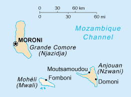
Mohéli[mɔ.e.li], also known as Mwali, is an autonomous island that forms part of the Union of the Comoros. It is the smallest of the three major islands in the country. It is located in the Indian Ocean off the coast of Africa and it is the smallest of the four major Comoro Islands. Its capital and largest city is Fomboni.
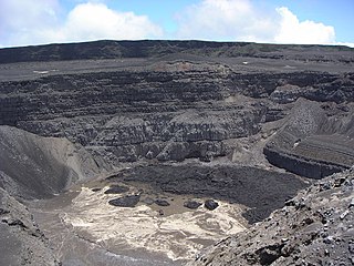
Mount Karthala or Karthola is an active volcano and the highest point of the Comoros at 2,361 m (7,746 ft) above sea level. It is the southernmost and larger of the two shield volcanoes forming Grande Comore island, the largest island in the nation of Comoros. The Karthala volcano is very active, having erupted more than 20 times since the 19th century. Frequent eruptions have shaped the volcano's 3 km by 4 km summit caldera, but the island has largely escaped broad destruction. Eruptions on April 17, 2005 and May 29, 2006 ended a period of quiet.

The Comoros national football team represents the Comoros in international football and is controlled by the Comoros Football Federation. It was formed in 1979, joined the Confederation of African Football (CAF) in 2003, and became a FIFA member in 2005. Comoros qualified for their first major tournament in 2021, after their 0–0 draw with Togo assured them of a place in the 2021 Africa Cup of Nations.
The Fédération de Football des Comores (FFC) is the governing body of football in the Comoros. It was founded in 1979, affiliated to FIFA in 2005 and to CAF in 2003. It organizes the national football league and the national team. The first official international played in Comoros was played on the 17 November 2007 against Madagascar for the qualification of 2010 FIFA World Cup and the African Cup of Nations 2010.
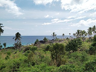
The Comoros forests is a terrestrial ecoregion which covers the Comoro Islands, which lie in the Mozambique Channel between Madagascar and East Africa. These include four main islands: Grande Comore, Anjouan and Mohéli, of the Union of the Comoros, and Mayotte, a department and region of France.

Mohéli National Park is a national park in the Comoros. It includes marine, coastal, and terrestrial areas on and around the island of Mohéli. The park has an area of 643.62 km2. Established as Mohéli Marine Park on 19 April 2001, it was first protected area in the Comoros. It was redesignated a national park in 2010. In 2015 the park was expanded to include about three-quarters of Mohéli's terrestrial area.

Pointes et plages de Saziley et Charifou is a protected area in Mayotte, a French island territory in the Comoro archipelago of the western Indian Ocean. It was established in 1997.

The Baie de Bouéni is a large bay in the south-west of the French island territory of Mayotte, in the Comoro Islands lying at the northern end of the Mozambique Channel between the East African country of Mozambique and Madagascar. It is about 5 km wide at its mouth, and 10 km in length. It was made a protected area in 2007.

The Mayotte Marine Natural Park is a marine park surrounding Mayotte, a French overseas region. Mayotte is part of the Comoro Islands archipelago, which lies within the Mozambique Channel in the western Indian Ocean. Established in 2010, the park covers the entirety of Mayotte's territorial waters and exclusive economic zone. It is contiguous with the Glorioso Islands Marine Natural Park, which was established two years later.
COVID-19 vaccination in Comoros is an ongoing immunisation campaign against severe acute respiratory syndrome coronavirus 2 (SARS-CoV-2), the virus that causes coronavirus disease 2019 (COVID-19), in response to the ongoing pandemic in the country.

The Forests of Mayotte National Nature Reserve is a protected area on Mayotte, an island overseas department of France in the Indian Ocean.

Shisiwani National Park is a national park along the Sima Peninsula in the eastern Comoros. It includes marine, coastal, and terrestrial areas along the western arm of the island of Anjouan. Its creation was announced in 2016 as part of a government effort to protect 25% of the Comoros by 2021. The park encompasses a saddle island and Ile de la selle off the tip of the peninsula and includes a significant coral reef and mangrove forest.

Coelacanth National Park is a national park off the main island of the Comoros. It includes seascape frequented by coelacanths along a thriving coral reef also visited by high concentrations of dolphins and whales. Its creation was announced in 2016 as part of a government effort to protect 25% of the Comoros by 2021.
References
- ↑ UNEP-WCMC (2021). Protected Area Profile for Comoros from the World Database of Protected Areas. Accessed 25 September 2021.