This article is about the list of regions of Baltic States by GDP.

Regions according to their gross domestic product in EUR. [1] [2] [3]
This article is about the list of regions of Baltic States by GDP.
Regions according to their gross domestic product in EUR. [1] [2] [3]

The province of Vercelli is a province in the Piedmont region of Italy. Its capital is Vercelli.
This is a list of first-level country subdivisions by nominal gross state product. This list shows top 100 largest subdivisions by GDP nominal and PPP. Those subdivisions which are the largest in their respective countries are shown in bold.

Kraków Metropolitan Area is a peculiar functional region including a big city - Kraków and neighbouring complex of settling units, connected with the metropolis by different interactive relations. Area including the city of Kraków and neighbouring powiats.
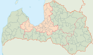
Riga Region, officially Riga Planning Region and shortened as RPR is one of five planning regions of Latvia, situated in the central part of Latvia, in and around the metropolis of Riga and along the shores of the Gulf of Riga. The state institution was founded on 12 October 2006, based on the creation of the region territory as prescribed by Regulations No. 133 of the Cabinet of Ministers as of 25 March 2003, the "Regulations on Territories of Planning Regions".

Kurzeme Region, officially Kurzeme Planning Region, is one of the five planning regions of Latvia, it is situated in the western part of Latvia, at the shores of the Baltic Sea and Gulf of Riga. The state institution was founded on 2 October 2006, based on the creation of the region territory as prescribed by Regulations No. 133 of the Cabinet of Ministers as of 25 March 2003, the "Regulations on Territories of Planning Regions". As of 2020, the region's population was 237,407.

The Šumadija and Western Serbia is one of the five statistical regions of Serbia. It is also a level-2 statistical region according to the Nomenclature of Territorial Units for Statistics (NUTS). It was formed in 2010. As of 2022 census, the regions has a total of 1,819,318 inhabitants.

The Southern and Eastern Serbia is one of five statistical regions of Serbia. It is also a level-2 statistical region according to the European NUTS. It was formed in 2010. As of 2022 census, the region has a total of 1,406,050 inhabitants.
This article contains economic statistics of the country Singapore. The GDP, GDP Per Capita, GNI Per Capita, Total Trade, Total Imports, Total Exports, Foreign Reserves, Current Account Balance, Average Exchange Rate, Operating Revenue and Total Expenditure are mentioned in the table below for years 1965 through 2018.

Zemgale Planning Region is a planning region of Latvia located within the south-center of the country. Established in 2002, the planning region contains 22 municipalities: 20 local governments and two major cities, the largest being Jelgava. As of 2020, the region's population was 228,409.
Latgale Planning Region also known as Latgale Region, is one of the five planning regions of Latvia, it is situated in the eastern part of Latvia. The state institution was founded on 2 October 2006, based on the creation of the region territory as prescribed by Regulations No. 133 of the Cabinet of Ministers as of 25 March 2003, the "Regulations on Territories of Planning Regions". As of 2020, the region's population was 281,116.

Vidzeme Region, officially Vidzeme Planning Region is one of the five planning regions of Latvia, it is situated in the northern part of Latvia. The state institution was founded on 2 October 2006, based on the creation of the region territory as prescribed by Regulations No. 133 of the Cabinet of Ministers as of 25 March 2003, the "Regulations on Territories of Planning Regions". As of 2020, the region's population was 211,309.

Riga Region, officially Riga Planning Region is one of the five planning regions of Latvia, it is situated in the central part of Latvia. The state institution was founded on 2 October 2006, based on the creation of the region territory as prescribed by Regulations No. 133 of the Cabinet of Ministers as of 25 March 2003, the "Regulations on Territories of Planning Regions". After the 2021 reform some Riga Region's lands were incorporated into Kurzeme and Vidzeme.

The Panevėžys urban area is the urban area of Panevėžys. The urban area covers two municipalities in the Panevėžys County, with an area of 60 km2
| History |  | |
|---|---|---|
| Geography | ||
| Politics | ||
| Economy | ||
| Sport | ||