
A number of rivers are known to have reversed the direction of their flow, either permanently or temporarily, in response to geological activity, weather events, climate change, tides, or direct human intervention.
A number of rivers are known to have reversed the direction of their flow, either permanently or temporarily, in response to geological activity, weather events, climate change, tides, or direct human intervention.
| River | Original outlet | Current outlet | Continent | Date of reversal | Cause of reversal | References |
|---|---|---|---|---|---|---|
| Amazon River | Pacific Ocean | Atlantic Ocean | South America | Cretaceous period | Formation of Andes Mountains | [1] |
| Wisconsin River | Great Lakes Basin | Mississippi River | North America | Pleistocene Epoch | Pre-Illinoian glaciers | [2] |
| River | Original outlet | Current outlet | Continent | Date of reversal | Cause of reversal | References |
|---|---|---|---|---|---|---|
| Chicago River | Lake Michigan | Mississippi River | North America | 1900 | Construction of Chicago Sanitary and Ship Canal | [1] |
All tidal sections of rivers reverse their flow with the tide about twice a day (or semidiurnally), by definition. The following are notable examples. [3]
| River | Outlet | Continent | References |
|---|---|---|---|
| Hudson River | Upper New York Bay | North America | [3] |
| Saint John River (Reversing Falls) | Bay of Fundy | North America | [4] |
| Salmon River | Bay of Fundy | North America | [5] |
| Channel of Vivari | Straits of Corfu | Europe | [6] |
| River | Outlet | Continent | Cause of reversal | References |
|---|---|---|---|---|
| Krupa River | Neretva River | Europe | High water levels of the Neretva River | [7] |
| Petexbatún River | Pasión River | Central America | Winter rain flooding of the Pasión River | [8] |
| Qiantang River | Hangzhou Bay | Asia | Tidal bore in Hangzhou Bay | [9] |
| Tonlé Sap River | Mekong River | Asia | Monsoon flooding of the Mekong River | [10] |
Hurricane storm surges often cause temporary reversals of coastal rivers. [1]
| River | Outlet | Continent | Date of reversal | Cause of reversal | References |
|---|---|---|---|---|---|
| Chicago River [lower-alpha 1] | Mississippi River | North America | 2017 and others [lower-alpha 2] | Storm surge | [11] |
| Mississippi River | Gulf of Mexico | North America | 1812 | Tectonic uplift caused by New Madrid earthquakes | [12] |
| 2005 | Storm surge from Hurricane Katrina | [1] | |||
| 2012 | Storm surge from Hurricane Isaac | [1] [13] | |||
| 2021 | Storm surge from Hurricane Ida | [14] |

Tides are the rise and fall of sea levels caused by the combined effects of the gravitational forces exerted by the Moon and are also caused by the Earth and Moon orbiting one another.

The Chicago River is a system of rivers and canals with a combined length of 156 miles (251 km) that runs through the city of Chicago, including its center. Though not especially long, the river is notable because it is one of the reasons for Chicago's geographic importance: the related Chicago Portage is a link between the Great Lakes and the Mississippi River Basin, and ultimately the Gulf of Mexico.

A flood is an overflow of water that submerges land that is usually dry. In the sense of "flowing water", the word may also be applied to the inflow of the tide. Floods are of significant concern in agriculture, civil engineering and public health. Human changes to the environment often increase the intensity and frequency of flooding. Examples for human changes are land use changes such as deforestation and removal of wetlands, changes in waterway course or flood controls such as with levees. Global environmental issues also influence causes of floods, namely climate change which causes an intensification of the water cycle and sea level rise. For example, climate change makes extreme weather events more frequent and stronger. This leads to more intense floods and increased flood risk.

The River Severn, at 220 miles (354 km) long, is the longest river in Great Britain. It is also the river with the most voluminous flow of water by far in all of England and Wales, with an average flow rate of 107 m3/s (3,800 cu ft/s) at Apperley, Gloucestershire. It rises in the Cambrian Mountains in mid Wales, at an altitude of 2,001 feet (610 m), on the Plynlimon massif, which lies close to the Ceredigion/Powys border near Llanidloes. The river then flows through Shropshire, Worcestershire and Gloucestershire. The county towns of Shrewsbury, Worcester and Gloucester lie on its course.

The Bay of Fundy is a bay between the Canadian provinces of New Brunswick and Nova Scotia, with a small portion touching the U.S. state of Maine. It is an arm of the Gulf of Maine. Its tidal range is the highest in the world. The name is probably a corruption of the French word fendu, meaning 'split'.

An estuary is a partially enclosed coastal body of brackish water with one or more rivers or streams flowing into it, and with a free connection to the open sea. Estuaries form a transition zone between river environments and maritime environments and are an example of an ecotone. Estuaries are subject both to marine influences such as tides, waves, and the influx of saline water, and to fluvial influences such as flows of freshwater and sediment. The mixing of seawater and freshwater provides high levels of nutrients both in the water column and in sediment, making estuaries among the most productive natural habitats in the world.

A storm surge, storm flood, tidal surge, or storm tide is a coastal flood or tsunami-like phenomenon of rising water commonly associated with low-pressure weather systems, such as cyclones. It is measured as the rise in water level above the normal tidal level, and does not include waves.

A tidal bore, often simply given as bore in context, is a tidal phenomenon in which the leading edge of the incoming tide forms a wave of water that travels up a river or narrow bay, reversing the direction of the river or bay's current. It is a strong tide that pushes up the river, against the current.
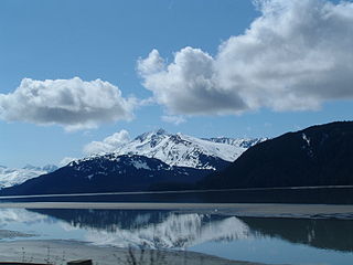
Turnagain Arm is a waterway into the northwestern part of the Gulf of Alaska. It is one of two narrow branches at the north end of Cook Inlet, the other being Knik Arm. Turnagain is subject to climate extremes and large tide ranges.
Slack tide or slack water is the short period in a body of tidal water when the water is completely unstressed, and there is no movement either way in the tidal stream. It occurs before the direction of the tidal stream reverses. Slack water can be estimated using a tidal atlas or the tidal diamond information on a nautical chart. The time of slack water, particularly in constricted waters, does not occur at high and low water, and in certain areas, such as Primera Angostura, the ebb may run for up to three hours after the water level has started to rise. Similarly, the flood may run for up to three hours after the water has started to fall. In 1884, Thornton Lecky illustrated the phenomenon with an inland basin of infinite size, connected to the sea by a narrow mouth. Since the level of the basin is always at mean sea level, the flood in the mouth starts at half tide, and its velocity is at its greatest at the time of high water, with the strongest ebb occurring conversely at low water.

Pointe à la Hache is a census-designated place (CDP) and unincorporated community in Plaquemines Parish, Louisiana, United States. Located on the east bank of the Mississippi River, the village has been the seat for Plaquemines Parish since the formation of the parish. As of the 2020 census, its population was 183, less than half its 1930 population. It suffered severe damage from Hurricane Katrina in 2005 and Tropical Storm Lee in 2011.

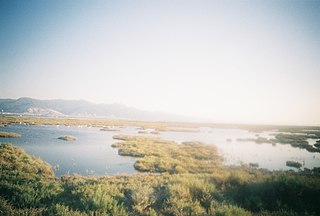
A tidal marsh is a marsh found along rivers, coasts and estuaries which floods and drains by the tidal movement of the adjacent estuary, sea or ocean. Tidal marshes experience many overlapping persistent cycles, including diurnal and semi-diurnal tides, day-night temperature fluctuations, spring-neap tides, seasonal vegetation growth and decay, upland runoff, decadal climate variations, and centennial to millennial trends in sea level and climate.

The Shubenacadie River is a river in Nova Scotia, Canada. It has a meander length of approximately 72 km from its source at Shubenacadie Grand Lake to its mouth at the historic seaport village of Maitland on Cobequid Bay, site of the building of the William D. Lawrence, the largest wooden ship ever built in Canada. In 2009, the I Backpack Canada blog named the Shubenacadie one of the top five whitewater rivers in Canada. The lower 30 km of the river is tidal and the river experiences a tidal bore twice daily, with some bores reaching up to 3 m in height at certain points along the river. Local tourism operators offer adventure seekers a chance to ride with the bore on high-horse power Zodiac Hurricanes. Tidal Bore Rafting was invented at the Tidal Bore Rafting Resort by H. Knoll. It is also a popular surfing spot for experienced Sea Kayakers.
A tidal river is a river whose flow and level are caused by tides. A section of a larger river affected by the tides is a tidal reach, but it may sometimes be considered a tidal river if it had been given a separate and another title name.

In geology, cross-bedding, also known as cross-stratification, is layering within a stratum and at an angle to the main bedding plane. The sedimentary structures which result are roughly horizontal units composed of inclined layers. The original depositional layering is tilted, such tilting not being the result of post-depositional deformation. Cross-beds or "sets" are the groups of inclined layers, which are known as cross-strata.

The geography of Arkansas varies widely. The state is covered by mountains, river valleys, forests, lakes, and bayous in addition to the cities of Arkansas. Hot Springs National Park features bubbling springs of hot water, formerly sought across the country for their healing properties. Crowley's Ridge is a geological anomaly rising above the surrounding lowlands of the Mississippi embayment.

A stream is a continuous body of surface water flowing within the bed and banks of a channel. Depending on its location or certain characteristics, a stream may be referred to by a variety of local or regional names. Long, large streams are usually called rivers, while smaller, less voluminous and more intermittent streams are known as streamlets, brooks or creeks.

A river is a natural flowing watercourse, usually a freshwater stream, flowing on the Earth's land surface or inside caves towards another waterbody at a lower elevation, such as an ocean, sea, bay, lake, wetland, or another river. In some cases, a river flows into the ground or becomes dry at the end of its course without reaching another body of water. Small rivers can be referred to by names such as creek, brook, and rivulet. There are no official definitions for these various generic terms for a watercourse as applied to geographic features, although in some countries or communities, a stream is customarily referred to by one of these names as determined by its size. Many names for small rivers are specific to geographic location; examples are "run" in some parts of the United States, "burn" in Scotland and Northeast England, and "beck" in Northern England. Sometimes a river is defined as being larger than a creek, but not always; in English the language is vague compared to some langauges like French, where a fleuve flows into the sea and a rivière is a tributary of another rivière or fleuve.

Coastal flooding occurs when dry and low-lying land is submerged (flooded) by seawater. The range of a coastal flooding is a result of the elevation of floodwater that penetrates the inland which is controlled by the topography of the coastal land exposed to flooding. The seawater can flood the land via several different paths: direct flooding, overtopping of a barrier, or breaching of a barrier. Coastal flooding is largely a natural event. Due to the effects of climate change and an increase in the population living in coastal areas, the damage caused by coastal flood events has intensified and more people are being affected.
Sedimentation enhancing strategies are environmental management projects aiming to restore and facilitate land-building processes in deltas. Sediment availability and deposition are important because deltas naturally subside and therefore need sediment accumulation to maintain their elevation, particularly considering increasing rates of sea-level rise. Sedimentation enhancing strategies aim to increase sedimentation on the delta plain primarily by restoring the exchange of water and sediments between rivers and low-lying delta plains. Sedimentation enhancing strategies can be applied to encourage land elevation gain to offset sea-level rise. Interest in sedimentation enhancing strategies has recently increased due to their ability to raise land elevation, which is important for the long-term sustainability of deltas.
| Large-scale features | |
|---|---|
| Alluvial rivers | |
| Bedrock river | |
| Bedforms | |
| Regional processes | |
| Mechanics | |