Related Research Articles
The geology of Wales is complex and varied; its study has been of considerable historical significance in the development of geology as a science. All geological periods from the Cryogenian to the Jurassic are represented at outcrop, whilst younger sedimentary rocks occur beneath the seas immediately off the Welsh coast. The effects of two mountain-building episodes have left their mark in the faulting and folding of much of the Palaeozoic rock sequence. Superficial deposits and landforms created during the present Quaternary period by water and ice are also plentiful and contribute to a remarkably diverse landscape of mountains, hills and coastal plains.
The Neath Disturbance is a geological structure which stretches across south Wales from Swansea Bay northeastwards as far as Hereford in western England. It consists of a series of both faults and associated folds which were active during the mountain-building period known as the Variscan orogeny. This line of weakness probably featured in the earlier Caledonian Orogeny and perhaps reflects a more ancient line of weakness in the basement rocks.
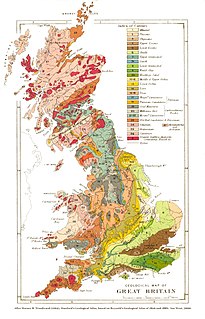
The geological structure of Great Britain is complex, resulting as it does from a long and varied geological history spanning more than two billion years. This piece of the Earth's crust has experienced several episodes of mountain building or 'orogenies', each of which has added further complexity to the picture.
The Bronnant Fault is a geological fault affecting the lower Palaeozoic rocks of the counties of Ceredigion and Pembrokeshire in West Wales. The feature is mapped over part of its length as the Bronnant Fault Zone and is closely associated with the Glandyfi Lineament, a similarly aligned zone of faulting and folding. The rocks of the Aberystwyth Grits Group dating from the Llandovery epoch of the Silurian period thicken markedly to the west of the fault suggesting it was active at the time of their deposition. North of Lledrod its alignment is affected by cross-cutting east–west faults, including the Ystwyth Fault Zone. Its alignment is sub-parallel to the coast of Cardigan Bay thus curving from a north–south alignment in the north through a northeast–southwest alignment until it merges with broadly east–west aligned faults in northeast Pembrokeshire.
The Machrihanish Coalfield is a coalfield on the Kintyre peninsula in southwest Scotland. It is one of the smallest British coalfields. With the exception of a thin coal beneath the Lyoncross Limestone in the overlying Upper Limestone Formation, all of the coal-bearing strata are found within the Limestone Coal Formation, a subdivision of the Clackmannan Group; all being strata of Namurian age. There are numerous seams of which the Main Coal is the principal one, being some 3 to 4m thick. A further, higher seam known as the Kilkivan Coal has also been worked. The full sequence is:

The Bristol Coalfield is a geologically complex coalfield in the west of England. Comprising the coal-bearing rocks arranged around the Coalpit Heath Syncline and Kingsdown Anticline, it extends beneath the eastern parts of the city of Bristol and northwards through southern Gloucestershire. The coalfield is sometimes referred to together with the Somerset Coalfield, which lies to its south, as the Bristol and Somerset Coalfield. There are also two outlying coal-mining areas, the Severn Coalfield and the Nailsea Basin which are described below.

The Sherwood Sandstone Group is a Triassic lithostratigraphic group which is widespread in Britain, especially in the English Midlands. The name is derived from Sherwood Forest in Nottinghamshire which is underlain by rocks of this age. It has economic importance as the reservoir of the Morecambe Bay gas field, the second largest gas field in the UK.
The Central Wales Lineament is a north–south aligned zone of geological faults and folds which runs for scores of miles through Wales and which gives rise to a number of landscape features. The lineament lies along the axis of the Central Wales Syncline, both following the generally northeast–southwest Caledonide trend though its central section is more north–south aligned.
The Cosheston Group is an early Devonian lithostratigraphic group in west Wales. The name is derived from the village of Cosheston in south Pembrokeshire. The Group comprises the Llanstadwell, Burton Cliff, Mill Bay, Lawrenny Cliff and New Shipping formations. The strata are exposed in the Milford Haven area of southern Pembrokeshire where several partial type sections are defined. The outcrop extends around the northern and southern shores of the Haven. It is bounded to the north by the Benton Fault between the villages of Rosemarket and Lawrenny, and extends east to New Shipping and west almost to the town of Milford Haven itself. The rocks of this group have also previously been known as the Cosheston Beds.

The Milford Haven Group is a late Silurian to early Devonian lithostratigraphic group in west Wales. The name is derived from the estuary and town of Milford Haven in south Pembrokeshire. The Group comprises calcareous marls with occasional sandstones along with conglomerates and breccias.
The geology of West Sussex in southeast England comprises a succession of sedimentary rocks of Cretaceous age overlain in the south by sediments of Palaeogene age. The sequence of strata from both periods consists of a variety of sandstones, mudstones, siltstones and limestones. These sediments were deposited within the Hampshire and Weald basins. Erosion subsequent to large scale but gentle folding associated with the Alpine Orogeny has resulted in the present outcrop pattern across the county, dominated by the north facing chalk scarp of the South Downs. The bedrock is overlain by a suite of Quaternary deposits of varied origin. Parts of both the bedrock and these superficial deposits have been worked for a variety of minerals for use in construction, industry and agriculture.

The Exmoor Group is a late Devonian to early Carboniferous lithostratigraphic group in southwest England whose outcrop extends from Croyde in north Devon east across Exmoor to Minehead in west Somerset. The group comprises the following formations the:
The geology of Northumberland in northeast England includes a mix of sedimentary, intrusive and extrusive igneous rocks from the Palaeozoic and Cenozoic eras. Devonian age volcanic rocks and a granite pluton form the Cheviot massif. The geology of the rest of the county is characterised largely by a thick sequence of sedimentary rocks of Carboniferous age. These are intruded by both Permian and Palaeogene dykes and sills and the whole is overlain by unconsolidated sediments from the last ice age and the post-glacial period. The Whin Sill makes a significant impact on Northumberland's character and the former working of the Northumberland Coalfield significantly influenced the development of the county's economy. The county's geology contributes to a series of significant landscape features around which the Northumberland National Park was designated.
This article describes the geology of the Broads, an area of East Anglia in eastern England characterised by rivers, marshes and shallow lakes (‘broads’). The Broads is designated as a protected landscape with ‘status equivalent to a national park’.
References
- ↑ Trewin, NH (ed) 2002. The Geology of Scotland, (4th edn) The Geological Society, London
- ↑ British Geological Survey, 1:50,000 scale geological map of Scotland sheet 129, British Geological Survey, Keyworth, Notts
- ↑ British Geological Survey 2007, Bedrock Geology UK North, 1:625,000 scale geological map, British Geological Survey, Keyworth, Notts
- ↑ British Geological Survey, British Regional Geology 2: Northern Highlands of Scotland, British Geological Survey, Nottingham
- ↑ British Geological Survey, special 1:50,000 sheet Assynt, British Geological Survey, Nottingham
- ↑ Goodenough, K.M. & Krabbendam, M. 2011 A Geological Excursion Guide to the North-west Highlands of Scotland, Edinburgh Geological Society , ISBN 978-1-905267-53-8
- ↑ British Geological Survey, British Regional Geology 7: Northern England, British Geological Survey, Nottingham
- ↑ British Geological Survey, 1:50,000 scale geological maps of England & Wales sheets 133 & 134, British Geological Survey, Keyworth, Notts
- ↑ British Geological Survey British Regional Geology 1: Orkney and Shetland, British Geological Survey, Nottingham