Related Research Articles
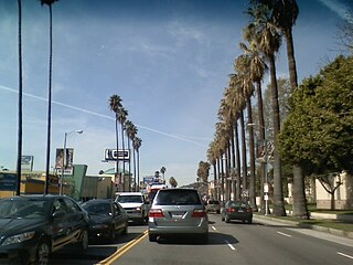
Sunset Boulevard is a boulevard in the central and western part of Los Angeles, California, United States, that stretches from the Pacific Coast Highway in Pacific Palisades east to Figueroa Street in Downtown Los Angeles. It is a major thoroughfare in the cities of Beverly Hills and West Hollywood, as well as several districts in Los Angeles.
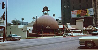
Brown Derby was a chain of restaurants in Los Angeles, California. The first and best known was shaped like a derby hat, an iconic image that became synonymous with the Golden Age of Hollywood. It was opened by Wilson Mizner in 1926. The chain was started by Robert H. Cobb and Herbert K. Somborn in the 1920s. The original Brown Derby restaurants had closed or had been converted to other uses by the 1980s, though a Disney-backed Brown Derby national franchising program revived the brand in the 21st century. It is often incorrectly thought that the Brown Derby was a single restaurant, and the Wilshire Boulevard and Hollywood branches are frequently confused.
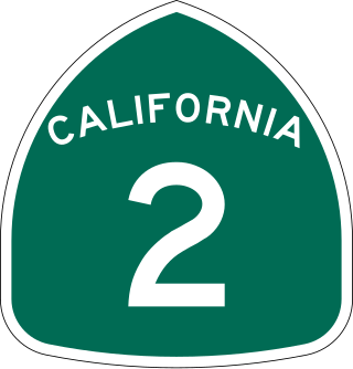
State Route 2 (SR 2) is a state highway in the U.S. state of California. It connects the Los Angeles Basin with the San Gabriel Mountains and the Victor Valley in the Mojave Desert. The highway's southwestern end is at the intersection of Centinela Avenue at the Santa Monica-Los Angeles border and its northeastern end is at SR 138 east of Wrightwood. The SR 2 is divided into four segments, and it briefly runs concurrently with U.S. Route 101 (US 101) and Interstate 210 (I-210). The southwestern section of SR 2 runs along a segment of the east–west Santa Monica Boulevard, an old routing of US 66, to US 101 in East Hollywood; the second section runs along segments of both the north–south Alvarado Street and Glendale Boulevard in Echo Park; the third section to I-210 in Glendale is known as the north–south Glendale Freeway; and the northeastern portion from I-210 in La Cañada Flintridge to SR 138 is designated as the Angeles Crest Highway.

Little Armenia is a neighborhood in Central Los Angeles, California. It is named after the Armenians who escaped genocide and made their way to Los Angeles during the early part of the 20th century.
Laurel Canyon is a mountainous neighborhood in the Hollywood Hills region of the Santa Monica Mountains, within the Hollywood Hills West district of Los Angeles, California. The main thoroughfare of Laurel Canyon Boulevard connects the neighborhood with the more urbanized parts of Los Angeles to the north and south, between Ventura Boulevard and Hollywood Boulevard.

Wilshire Boulevard (['wɪɫ.ʃɚ]) is a prominent 15.83 mi (25.48 km) boulevard in the Los Angeles area of Southern California, extending from Ocean Avenue in the city of Santa Monica east to Grand Avenue in the Financial District of downtown Los Angeles. One of the principal east–west arterial roads of Los Angeles, it is also one of the major city streets through the city of Beverly Hills. Wilshire Boulevard runs roughly parallel to Santa Monica Boulevard from Santa Monica to the west boundary of Beverly Hills. From the east boundary, it runs a block south of Sixth Street to its terminus.

Santa Monica Boulevard is a major west–east thoroughfare in Los Angeles County, California, United States. It runs from Ocean Avenue in Santa Monica near the Pacific Ocean to Sunset Boulevard at Sunset Junction in Los Angeles. It passes through Beverly Hills and West Hollywood. A portion of it is designated as California State Route 2, while the full avenue was Historic Route 66.

San Vicente Boulevard is a major northwest-southeast thoroughfare located in the western portion of the metropolitan area of Los Angeles, CA.

Highland Avenue is a north–south road in Los Angeles. It is a major thoroughfare that runs from Cahuenga Boulevard and the US 101 Freeway in Hollywood from the north end to Olympic Boulevard in Mid-City Los Angeles on the south end. Highland then is a small residential street from Olympic Boulevard south to Adams Boulevard. For through access, Highland swerves west into Edgewood Place which accesses La Brea Avenue.

Vermont Avenue is one of the longest running north–south streets in City of Los Angeles and Los Angeles County, California. With a length of 23.3 miles (37.5 km), is the third longest of the north–south thoroughfares in the region. For most of its length between its southern end in San Pedro and south of Downtown Los Angeles, it runs parallel to the west of the Harbor Freeway (I-110).

The Sawtelle Line was an interurban railway route primarily operated by the Pacific Electric Railway that ran between Downtown Los Angeles and Santa Monica, California. The line was established by the Pasadena and Pacific Railway between 1896 and 1901, with passenger service running until 1940.

The South Hollywood–Sherman Line was a suburban route of the Pacific Electric Railway. The line ran between Downtown Los Angeles and the suburb of Sherman. The line was named after Moses Sherman, who built the line and the Sherman street car yard on the line in West LA. The large 5.56-acre (2.25 ha) rail facility was on Santa Monica Boulevard just west of La Cienega Boulevard. The yard had a steam power house, a car barn and a shop building.

The Hollywood Line was a local streetcar line of the Pacific Electric Railway. It primarily operated between Downtown Los Angeles and Hollywood, with some trips as far away as Beverly Hills and West Los Angeles. It was the company's busiest route prior to the opening of the Hollywood Subway. Designated as route 32, the line operated from 1909 until 1954.

Emma Ferreira is an English contemporary artist, sculptor, photographer, entrepreneur and philanthropist. She lives and works in Los Angeles and maintains a studio in Culver City, California.
The Los Angeles Pacific Railroad (1896−1911) (LAP) was an electric public transit and freight railway system in Los Angeles County, California. At its peak it had 230 miles (370 km) of track extending from Downtown Los Angeles to the Westside, Santa Monica, and the South Bay towns along Santa Monica Bay.
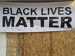
This is a list of protests that took place in Los Angeles County, California following the murder of George Floyd on May 25, 2020, in Minneapolis, Minnesota, while in police custody.
References
- ↑ Hilburn, Robert (March 21, 2007). "A tenacious troubadour". Los Angeles Times . Retrieved April 27, 2011.
- ↑ Swing (5) –Swing at Discogs (list of releases)