Related Research Articles

Sabah is a state of Malaysia located on the northern portion of Borneo, in the region of East Malaysia. Sabah has land borders with the Malaysian state of Sarawak to the southwest and Indonesia's North Kalimantan province to the south. The Federal Territory of Labuan is an island just off the Sabah coast. Sabah shares maritime borders with Vietnam to the west and the Philippines to the north and east. Kota Kinabalu is the state capital city, the economic centre of the state, and the seat of the Sabah state government. Other major towns in Sabah include Sandakan and Tawau. The 2015 census recorded a population of 3,543,500 in the state, and in 2019 it was estimated to have grown to over 3.9 million. Sabah has an equatorial climate with tropical rainforests and abundant animal and plant species. The state has long mountain ranges on the west side which forms part of the Crocker Range National Park. Kinabatangan River, the second longest river in Malaysia runs through Sabah, and Mount Kinabalu is the highest point of Sabah as well as of Malaysia.
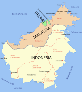
East Malaysia, also known as Sabah, Sarawak and Labuan or Malaysian Borneo, is the part of Malaysia on and near the island of Borneo, the world's third largest island. It consists of the Malaysian states of Sabah and Sarawak, as well as the Federal Territory of Labuan. Labuan is an island in a small archipelago near the coast of Sabah. East Malaysia lies to the east of Peninsular Malaysia, the part of the country on the Malay Peninsula. The two are separated by the South China Sea.
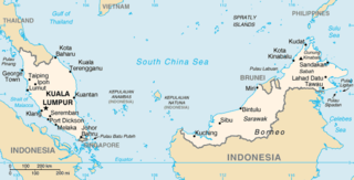
The geography of Malaysia includes both the physical and the human geography of Malaysia, a Southeast Asian country made up of two major landmasses separated by water—Peninsular Malaysia to the west and East Malaysia to the east—and numerous smaller islands that surround those landmasses. Peninsular Malaysia is on the southernmost part of the Malay Peninsula, south of Thailand, north of Singapore and east of the Indonesian island of Sumatra; East Malaysia comprises most of the northern part of Borneo island, and shares land borders with Brunei to the north and Indonesian Borneo to the south.

Kota Kinabalu, colloquially referred to as KK, is the state capital of Sabah, Malaysia. It is also the capital of the Kota Kinabalu District as well as the West Coast Division of Sabah. The city is located on the northwest coast of Borneo facing the South China Sea. The Tunku Abdul Rahman National Park lies to its west and Mount Kinabalu, which gave the city its name, is located to its east. Kota Kinabalu has a population of 452,058 according to the 2010 census; when the adjacent Penampang and Putatan districts are included, the metro area has a combined population of 628,725.
Lahad Datu is the capital of the Lahad Datu District in the Dent Peninsula on Tawau Division of Sabah, Malaysia. Its population was estimated to be around 27,887 in 2010. The town is surrounded by stretches of cocoa and palm oil plantations. It is also an important timber exporting port. The town has an airport for domestic flights.
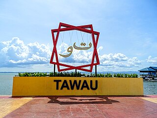
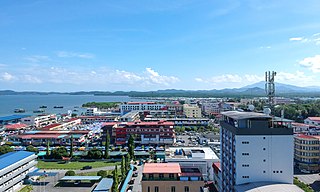
Tawau formerly known as Tawao, is the capital of the Tawau District in Sabah, Malaysia. It is the third-largest city in Sabah, after Kota Kinabalu and Sandakan. It is located on the Semporna Peninsula in the southeast coast of the state in the administrative centre of Tawau Division, which is bordered by the Sulu Sea to the east, the Celebes Sea to the south at Cowie Bay and shares a border with North Kalimantan, Indonesia. The town had an estimated population as of 2010, of 113,809, while the whole municipality area had a population of 397,673.
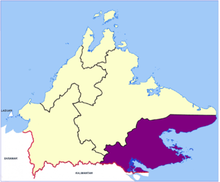
Tawau Division is one of the five administrative sub-divisions of Sabah, Malaysia. It occupies a total of 14,905 square kilometres or 20% of Sabah's territory. The main towns include the capital of Tawau, Lahad Datu, Kunak and Semporna. Tawau division has 26% of Sabah's total population, with the main indigenous groups consisting of the Bajau, Suluk, Ida'an, Tidong, Cocos, Murut, Lun Bawang/Lun Dayeh as well as a minority of mixed ethnic groups. Large numbers of both legal and illegal immigrants from Indonesia such as the Buginese and Torajans, from East Timor the Timorese, from the Philippines the Tausūg and Visayans as well South and West Asian immigrants such as Pakistanis, Indians and Arabs can be found in this area. As with the rest of Sabah, the division also has large numbers of ethnic Chinese.

Tawau Airport is an airport located 15 nautical miles north east of Tawau, Sabah, Malaysia. It is one of two airports in Sabah with immigration counters for international flights, the other being Kota Kinabalu International Airport. Tawau Airport serves the districts of Tawau, Kunak and Semporna and is the nearest airport to the diving islands of Sipadan, Mabul and Kapalai, all of which are located in the latter district.
Mount Danum is a mountain located at the Tawau Division of Sabah, Malaysia. With a height of 1,093 metres (3,586 ft), it is the highest peak in the Danum Valley Conservation Area.
Mount Bombalai is a volcanic cone mountain in the Tawau Division of Sabah, Malaysia. It reaches a height of approximately 531 metres (1,742 ft).

The history of Sabah can be traced back to about 23–30,000 years ago when evidence suggests the earliest human settlement in the region existed. The history is interwoven with the history of Brunei and the history of Malaysia, which Sabah was previously part of and is currently part of respectively. The earliest recorded history of Sabah being part of any organised civilisation began in the early 15th century during the thriving era of the Sultanate of Brunei. Prior to this, early inhabitants of the land lived in predominantly tribal societies, although such tribal societies had continued to exist until the 1900s. The eastern part of Sabah was ceded to the Sultan of Sulu by the Sultan of Brunei in 1658 for the former helping a victory over Brunei enemies, but many sources stated it had not been ceded at all. By the late 19th century, both territories previously owned by Sultan of Brunei and Sultan of Sulu was granted to British syndicate and later emerged as British North Borneo under the management of the North Borneo Chartered Company. Sabah became a protectorate of the United Kingdom in 1888 and subsequently became a Crown colony from 1946 until 1963, during which time it was known as Crown Colony of North Borneo. On 16 September 1963, Sabah merged with Malaya, Sarawak and Singapore to form Malaysia.
The Semporna Peninsula is a peninsula in southeastern of Sabah, Malaysia. It consists of coastal areas and numerous isolated hills and mountains rising to over 305 metres (1,001 ft). The Peninsula is also considered as a volcanic arc of the region with several volcanoes active during the Holocene period is located on the area.
The 2015 Sabah earthquake struck Ranau, Sabah, Malaysia with a moment magnitude of 6.0 on 5 June, which lasted for 30 seconds. The earthquake was the strongest to affect Malaysia since the 1976 Sabah earthquake.

The Batu Tinagat Lighthouse is a lighthouse on Batu Tinagat of Tawau Division in Sabah, Malaysia. It is located approximately 10 kilometres from the Tawau town centre.

The Tawau District is an administrative district in the Malaysian state of Sabah, part of the Tawau Division which also includes the districts of Kunak, Lahad Datu, Semporna and Tawau. The capital of the district is in Tawau Town.
Mount Maria is a volcanic cone mountain located at the Tawau Division of Sabah, Malaysia. It reaches a height of approximately 1,067 metres (3,501 ft).
Mount Magdalena is a volcanic cone mountain located at the Tawau Division of Sabah, Malaysia. It reaches a height of approximately 1,310 metres (4,298 ft).
Mount Lucia is a volcanic cone mountain located at the Tawau Division of Sabah, Malaysia. It reaches a height of approximately 1,201 metres (3,940 ft).
The COVID-19 pandemic was confirmed to have reached Sabah, Malaysia, in March 2020. As of 27 January 2021, there are 47,737 confirmed cases.
References
- ↑ Geological Survey Department. British Territories in Borneo (1968). Bulletin - Geological Survey Department, British Territories in Borneo. H.M. Stationery Office.
- ↑ G. A. Chatfield (1972). Sabah, a general geography. Eastern Universities Press.
- ↑ Shalina R. (31 October 2017). "Ministry exploring volcano tourism in Tawau". The Borneo Post. Archived from the original on 20 May 2019. Retrieved 2020-12-19.
In Sabah, Tawau's Bombalai volcano is currently a dormant volcano and, since it estimated to have erupted thousands of years ago, it can be regarded as an ancient crater. Bombalai cinder cone is only a half-an-hour jungle walk from the entrance of Tawau Hills National Park.
- ↑ Lagatah Toyos (15 July 2018). "World's new tallest tree in Tawau Hills Park". Daily Express. Archived from the original on 20 May 2019. Retrieved 2020-12-19.
There are three main peaks in the form of extinct volcanoes, which were last active about 27,000 years ago, namely Mt Magdalena, Mt Lucia and Mt Maria.