Alaska
| | This section is empty. You can help by adding to it. (February 2013) |
Landmarks officially designated by local city or county governments in the United States.
| | This section is empty. You can help by adding to it. (February 2013) |
| | This section is empty. You can help by adding to it. (February 2013) |
| | This section is empty. You can help by adding to it. (February 2013) |
| | This section is empty. You can help by adding to it. (February 2013) |
| | This section is empty. You can help by adding to it. (February 2013) |
| | This section is empty. You can help by adding to it. (February 2013) |
| | This section is empty. You can help by adding to it. (February 2013) |
| | This section is empty. You can help by adding to it. (February 2013) |
| | This section is empty. You can help by adding to it. (February 2013) |
| | This section is empty. You can help by adding to it. (February 2013) |
| | This section is empty. You can help by adding to it. (February 2013) |
| | This section is empty. You can help by adding to it. (February 2013) |
| | This section is empty. You can help by adding to it. (February 2013) |
| | This section is empty. You can help by adding to it. (February 2013) |
| | This section is empty. You can help by adding to it. (February 2013) |
| | This section is empty. You can help by adding to it. (February 2013) |
| | This section is empty. You can help by adding to it. (February 2013) |
| | This section is empty. You can help by adding to it. (February 2013) |
| | This section is empty. You can help by adding to it. (February 2013) |
| | This section is empty. You can help by adding to it. (February 2013) |
| | This section is empty. You can help by adding to it. (February 2013) |
| | This section is empty. You can help by adding to it. (February 2013) |
| | This section is empty. You can help by adding to it. (February 2013) |
| | This section is empty. You can help by adding to it. (February 2013) |
| | This section is empty. You can help by adding to it. (February 2013) |
| | This section is empty. You can help by adding to it. (February 2013) |
| | This section is empty. You can help by adding to it. (February 2013) |
| | This section is empty. You can help by adding to it. (February 2013) |
| | This section is empty. You can help by adding to it. (February 2013) |
| | This section is empty. You can help by adding to it. (February 2013) |
| | This section is empty. You can help by adding to it. (February 2013) |
| | This section is empty. You can help by adding to it. (February 2013) |
Federal designations
State Registries

Southern California is a geographic and cultural region that generally comprises the southern portion of the U.S. state of California. It includes the Los Angeles metropolitan area and also the Inland Empire. The region generally contains ten of California's 58 counties: Imperial, Kern, Los Angeles, Orange, Riverside, San Bernardino, San Diego, Santa Barbara, San Luis Obispo and Ventura counties.

A California Historical Landmark (CHL) is a building, structure, site, or place in the U.S. state of California that has been determined to have statewide historical landmark significance.

Buildings, sites, districts, and objects in California listed on the National Register of Historic Places:

Santa Susana Pass State Historic Park is a California State Park of 670.68 acres (2.7141 km2) located in the city of Los Angeles, in Los Angeles County on the boundary between Ventura and Los Angeles counties, between the communities of Chatsworth and Simi Valley. Geologically, the park is located where the Simi Hills meet the Santa Susana Mountains. Here in the western part of the Transverse Ranges, the land is dominated by high, narrow ridges and deep canyons covered with an abundant variety of plant life. The park offers panoramic views of the rugged natural landscape as a striking contrast to the developed communities nearby. The park is also rich in archaeological, historical, and cultural significance.

The Old Santa Susana Stage Road, or Santa Susana Wagon Road, is a route taken by early travelers between the San Fernando Valley and Simi Valley near Chatsworth, California, via the Santa Susana Pass. The main route climbs through what is now the Santa Susana Pass State Historic Park, with a branch in Chatsworth Park South.

Los Angeles Historic-Cultural Monuments are sites which have been designated by the Los Angeles, California, Cultural Heritage Commission as worthy of preservation based on architectural, historic and cultural criteria.
The City of Ventura Historic Landmarks and Districts consist of buildings, sites, and neighborhoods designated by the City of Ventura, California, as historic landmarks and districts.
The Ventura County Historic Landmarks & Points of Interest consist of buildings, sites, and neighborhoods designated by Ventura County Cultural Heritage Board as historic landmarks and points of interest in Ventura County, California. The county board of supervisors created the Cultural Heritage Board in 1966 and in August 1968, two sites were designated: the Faulkner House near Santa Paula; and the Edwards Adobe in Saticoy. The scope was established to include the entire county: both cities and the unincorporated areas. The cities of Fillmore, Oxnard, Port Hueneme, Simi Valley, and Thousand Oaks have the county Cultural Heritage Board advise them and those designations are listed here. The cities of Moorpark, Ojai, Santa Paula, and Ventura established their own separate historic designation systems with the City of Ventura Historic Landmarks and Districts developing into an extensive list. The Port Hueneme Historical Society Museum houses historical artifacts, photographs and information on the history of the Hueneme area. The museum is in the Hueneme Bank Building.
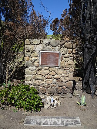
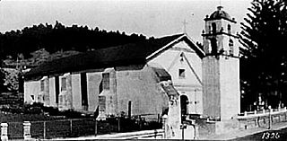
The Santa Gertrudis Asistencia, also known as the Santa Gertrudis Chapel, was an asistencia ("sub-mission") to the Mission San Buenaventura, part of the system of Spanish missions in Las Californias—Alta California. Built at an unknown date between 1792 and 1809, it was located approximately five miles from the main mission, inland and upstream along the Ventura River. The site was buried in 1968 by the construction of California State Route 33. Prior to the freeway's construction, archaeologists excavated and studied the site. A number of foundation stones were moved and used to create the Santa Gertrudis Asistencia Monument which was designated in 1970 as Ventura County Historic Landmark No. 11.

The Glendale Register of Historic Resources and Historic Districts consist of buildings, structures, bridges, statues, trees, and other objects designated by the City of Glendale, California, as significant historic resources or historic districts.