List of landmarks
Individual landmarks [4]
| Historic Property Name | Image | Address | Built | Style | Designation date | NRHP date |
|---|---|---|---|---|---|---|
| Adath Jeshurun Synagogue |  | 3400 Dupont Avenue South 44°56′28″N93°17′37″W / 44.94111°N 93.29361°W | 1927 | Classical Revival | 1998 | N/A |
| Anson Brooks Mansion | 2445 Park Avenue 44°57′27.2″N93°15′52″W / 44.957556°N 93.26444°W | 1907 | Venetian Gothic | 2015 | N/A | |
| Advance Thresher/Emerson-Newton Co. |  | 700–08 3rd Street South 44°58′36.5″N93°15′32″W / 44.976806°N 93.25889°W | 1901–1904 | Chicago Commercial | 1977 | 1977 |
| Architects and Engineers Building |  | 1200–08 2nd Avenue South 44°58′15″N93°16′26″W / 44.97083°N 93.27389°W | 1920 | Renaissance Revival | 1980 | 1984 |
| Augsburg Old Main |  | 731 21st Avenue South 44°57′56.5″N93°14′31″W / 44.965694°N 93.24194°W | 1901 | Renaissance Revival | 1984 | 1983 |
| Avalon Theater |  | 1500 Lake Street East 44°56′55″N93°15′13″W / 44.94861°N 93.25361°W | 1924/1937 | Streamline Moderne | 1990 | N/A |
| Charles T. Backus House | 212 West 36th Street 44°56′16.5″N93°16′55.7″W / 44.937917°N 93.282139°W | 1915 | Prairie School | 1987 | N/A | |
| Baker-Emerson House | 2215 Dupont Avenue North 45°0′7.2″N93°17′35″W / 45.002000°N 93.29306°W | 1883 | Queen Anne/Eastlake | 1995 | N/A | |
| Band Box Diner |  | 729 10th Street South 44°58′8.5″N93°15′48.5″W / 44.969028°N 93.263472°W | Vernacular/Programmatic | 2000 | N/A | |
| Bardwell–Ferrant House |  | 2500 Portland Avenue South 44°57′25.7″N93°16′5″W / 44.957139°N 93.26806°W | 1883/1890 | Queen Anne, Moorish | 1983 | 1984 |
| Basilica of St. Mary |  | 88 North 17th Street 44°58′23″N93°17′11″W / 44.97306°N 93.28639°W | 1907–13 | Classical Revival/Baroque Revival | 1986 | 1975 |
| Harington Beard House | 5100 Nicollet Avenue South 44°54′37″N93°16′42.5″W / 44.91028°N 93.278472°W | 1888 | Shingle | 1995 | N/A | |
| Bennett-McBride House |  | 3116 3rd Avenue South 44°56′45.8″N93°16′23″W / 44.946056°N 93.27306°W | 1891 | Queen Anne | 1976 | N/A |
| Charles C. Bovey House | 400 Clifton Avenue 44°58′0.5″N93°17′6″W / 44.966806°N 93.28500°W | 1916 | Colonial Revival | 1986 | N/A | |
| Fredrika Bremer Intermediate School |  | 1214 Lowry Avenue North 45°0′49″N93°17′42″W / 45.01361°N 93.29500°W | 1888 | Romanesque Revival | 1985 | 1978 |
| Frank and Karen Brooberg Residence | 727 East 24th Street 44°57′32″N93°15′48.5″W / 44.95889°N 93.263472°W | 1905 | Classical Revival | 1998 | N/A | |
| Butler Brothers Company Building |  | 518 1st Avenue North and 100/116 6th Street North 44°58′48″N93°16′29″W / 44.98000°N 93.27472°W | 1906–1908 | Chicago Commercial, Sullivanesque, and Gothic influences | 1973 | 1971 |
| Calvary Baptist Church |  | 2608 Blaisdell Avenue South 44°57′19″N93°16′48″W / 44.95528°N 93.28000°W | 1889 | Romanesque Revival | 1995 | 2021 |
| Camden Park State Bank | 705 42nd Avenue North 45°1′53″N93°17′18″W / 45.03139°N 93.28833°W | 1910, 1920 | Vernacular Neoclassical | 2015 | N/A | |
| Elbert L. Carpenter House |  | 314 Clifton Avenue 44°57′59″N93°17′2.7″W / 44.96639°N 93.284083°W | 1906 | Georgian Revival | 1978 | 1977 |
| Eugene J. Carpenter House |  | 300 Clifton Avenue 44°57′58.5″N93°17′0″W / 44.966250°N 93.28333°W | 1906 | Georgian Revival | 1978 | 1977 |
| Case-Lang House |  | 1508 Dupont Avenue North 44°59′40.2″N93°17′32.5″W / 44.994500°N 93.292361°W | 1865–85 | Greek Revival/Italianate | 1983 | N/A |
| Donald Cattanach House | 1031 13th Avenue S.E. 44°59′19.6″N93°14′1″W / 44.988778°N 93.23361°W | Cottage | 1985 | N/A | ||
| Chadwick Cottages |  | 2617 West 40th Street 44°55′49″N93°18′50.2″W / 44.93028°N 93.313944°W | 1902 | Cottage | 1983 | 1984 |
| Laura Chase Residence | 3045 5th Avenue South 44°56′48.8″N93°16′7.5″W / 44.946889°N 93.268750°W | 1904 | Shingle | 2012 | N/A | |
| Christ Church Lutheran |  | 3244 34th Avenue South 44°56′37″N93°13′24″W / 44.94361°N 93.22333°W | 1949 | Modern/International | 1978 | 2001 |
| Amos B. Coe House |  | 1700 3rd Avenue South 44°57′58″N93°16′23″W / 44.96611°N 93.27306°W | 1884, 1886 | Queen Anne | 1983 | 1984 |
| Como-Harriet Streetcar Line |  | 42nd Street West at Queen Avenue South 44°55′40″N93°18′34.5″W / 44.92778°N 93.309583°W | 1887/1908 | 1986 | 1977 | |
| Concrete Block House - 2611 3rd St N | 2611 Third Street North 45°0′23.1″N93°17′1.5″W / 45.006417°N 93.283750°W | 1885 | 1984 | N/A | ||
| Concrete Block House - 2617 3rd St N | 2617 Third Street North 45°0′23.4″N93°17′1.5″W / 45.006500°N 93.283750°W | 1885 | 1984 | N/A | ||
| Concrete Block House - 2619 3rd St N | 2619 Third Street North 45°0′23.7″N93°17′1.5″W / 45.006583°N 93.283750°W | 1885 | 1984 | N/A | ||
| Concrete Block House - 2705 3rd St N | 2705 Third Street North 45°0′26.8″N93°17′1.5″W / 45.007444°N 93.283750°W | 1885 | 1984 | N/A | ||
| Concrete Block House - 2729 3rd St N | 2729 Third Street North | 1885 | Demolished in 1996 | 1984 | N/A | |
| Concrete Block House - 2831 3rd St N | 2831 Third Street North 45°0′33.8″N93°17′1.5″W / 45.009389°N 93.283750°W | 1885 | 1984 | N/A | ||
| Concrete Block House - 2826 4th St N |  | 2826 Fourth Street North 45°0′33.4″N93°17′4.5″W / 45.009278°N 93.284583°W | 1885 | 1984 | N/A | |
| Concrete Block House - 2828 4th St N |  | 2828 Fourth Street North 45°0′33.8″N93°17′4.5″W / 45.009389°N 93.284583°W | 1885 | 1984 | N/A | |
| Concrete Block Rowhouses |  | 300–314½ 26th Avenue North 45°0′22″N93°17′2″W / 45.00611°N 93.28389°W | 1885 | 1984 | N/A | |
| Cream of Wheat Building |  | 730 Stinson Boulevard NE 44°59′53″N93°13′41″W / 44.99806°N 93.22806°W | 1928 | Moderne | 2005 | N/A |
| Crowell Block | 2957 Lyndale Avenue South 44°56′54.7″N93°17′16″W / 44.948528°N 93.28778°W | 1888 | Richardsonian Romanesque | 1985 | N/A | |
| B.O. Cutter House |  | 400 10th Avenue S.E. 44°58′58.3″N93°14′27″W / 44.982861°N 93.24083°W | Carpenter Gothic | 1976 | N/A | |
| Dania Hall |  | 427 Cedar Avenue | 1886 | Burned and demolished in 2000 | 1976 | 1974, de-listed in 2000 |
| F.E. Day House | 1900 Colfax Avenue South 44°57′51.5″N93°17′31.5″W / 44.964306°N 93.292083°W | Colonial Revival | 2009 | N/A | ||
| Deinard Residence | 1729 Morgan Avenue South 44°58′0.7″N93°18′15.3″W / 44.966861°N 93.304250°W | 1924 | Tudor Revival | 2014 | N/A | |
| Despatch Laundry Building | 2611 1st Avenue South 44°57′18.3″N93°16′35″W / 44.955083°N 93.27639°W | 1929 | Moorish Revival | 1984 | N/A | |
| Dunn Mansion |  | 337 Oak Grove Street 44°58′1.5″N93°17′4.5″W / 44.967083°N 93.284583°W | 1893 | Richardsonian Romanesque | 2011 | N/A |
| Farmers and Mechanics Savings Bank | 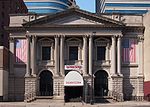 | 115 4th Street South 44°58′43.5″N93°16′4″W / 44.978750°N 93.26778°W | 1891–92, 1908 | Beaux-Arts Classical | 1980 | 1984 |
| Fire Station #13 |  | 4201 Cedar Avenue 44°55′36.3″N93°14′49″W / 44.926750°N 93.24694°W | 1923 | Craftsman/Bungalow | 2003 | 2003 |
| Fire Station #19 |  | 2001 University Avenue S.E. 44°58′33.5″N93°13′36.5″W / 44.975972°N 93.226806°W | 1893 | 1982 | 1982 | |
| Fire Station #28 |  | 2724 West 43rd Street 44°55′29″N93°18′50″W / 44.92472°N 93.31389°W | 1914 | 20th Century Period Revival | 1995 | 1993 |
| First Church of Christ Scientist | 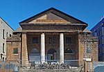 | 614–20 East 15th Street 44°58′6″N93°16′0″W / 44.96833°N 93.26667°W | Doric order | 1986 | 1986 | |
| Florence Court |  | 1022 University Avenue S.E. 44°58′51″N93°14′33″W / 44.98083°N 93.24250°W | 1886 | Queen Anne | 1983 | N/A |
| Flour Exchange Building |  | 310 4th Avenue South 44°58′42″N93°15′50″W / 44.97833°N 93.26389°W | 1892, 1909 | Chicago Commercial | 1980 | 1977 |
| Forum Cafeteria |  | 36–40 7th Street South 44°58′40.5″N93°16′26″W / 44.977917°N 93.27389°W | 1929 | Art Deco, Modern | 1975 | N/A (removed in 1987) |
| Foshay Tower | 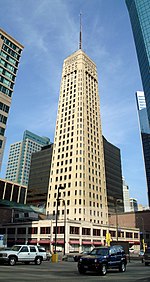 | 821–37 Marquette Avenue 44°58′28″N93°16′18″W / 44.97444°N 93.27167°W | 1927–29 | Art Deco | 1984 | 1978 |
| Fournier House |  | 3505 Sheridan Avenue North 45°1′8″N93°18′45″W / 45.01889°N 93.31250°W | 1910 | Bungalow/Craftsman | 1995 | 1995 |
| Fowler Methodist and Episcopal Church |  | 2011 Dupont Avenue South 44°57′45″N93°17′34″W / 44.96250°N 93.29278°W | 1894/1906 | Romanesque Revival | 1986 | 1976 |
| Franklin Avenue Bridge |  | Franklin Avenue at the Mississippi River 44°57′49″N93°13′23″W / 44.96361°N 93.22306°W | 1919–1923 | 1985 | 1978 | |
| Franklin Library |  | 1314 Franklin Avenue East 44°57′47″N93°15′21″W / 44.96306°N 93.25583°W | 1914 | Renaissance Revival | 1997 | 2000 |
| Benjamin and Cora Franklin House | 2405 West 22nd Street 44°57′36″N93°18′39″W / 44.96000°N 93.31083°W | 1915 | Prairie Style | 1996 | N/A | |
| Aaron and Naomi Friedell House | 2700 Chowen Avenue South 44°57′12″N93°19′31″W / 44.95333°N 93.32528°W | 1940 | Streamlined Moderne | 1996 | N/A | |
| Garlick-Magney House | 5329 Washburn Avenue South 44°54′22″N93°19′2″W / 44.90611°N 93.31722°W | 1922 | Medieval Cottage | 1987 | N/A | |
| Gethsemane Episcopal Church |  | 901 4th Avenue South 44°58′20.5″N93°16′6″W / 44.972361°N 93.26833°W | 1883–84 | Gothic Revival | 1983 | 1984 |
| Gluek Building |  | 14 6th Street North 44°58′46″N93°16′26.5″W / 44.97944°N 93.274028°W | 1902 | Renaissance Revival | 1984 | N/A |
| John G. Gluek House and Carriage House |  | 2447 Bryant Avenue South 44°57′27.3″N93°17′25″W / 44.957583°N 93.29028°W | 1902 | Georgian Revival/Queen Anne | 1987 | 1990 |
| Grain Exchange Building |  | 400–412 4th Street South 44°58′40″N93°15′50″W / 44.97778°N 93.26389°W | 1900–1902, 1909, 1928 | Chicago Commercial/Renaissance Revival | 1977 | 1977 |
| Granada Theater |  | 3022 Hennepin Avenue 44°56′51.3″N93°17′55″W / 44.947583°N 93.29861°W | 1927 | Exotic Revival | 1991 | N/A |
| Green DeLaittre Warehouse | 500 North 3rd Street 44°59′8″N93°16′33″W / 44.98556°N 93.27583°W | 2010 | 1989 as contributing resource to Minneapolis Warehouse Historic District | |||
| Frank M. Groves House | 4885 East Lake Harriet Parkway 44°54′54″N93°18′26.3″W / 44.91500°N 93.307306°W | 1928 | Mediterranean Villa | 1987 | N/A | |
| Jacob Hafstad House |  | 159 Arthur Avenue S.E. 44°58′0″N93°12′59″W / 44.96667°N 93.21639°W | 1894 | Queen Anne/Eastlake | 1983 | 2015 as contributing resource to Prospect Park Residential Historic District |
| Handicraft Guild Building |  | 89–91 10th Street South 44°58′24.5″N93°16′26″W / 44.973472°N 93.27389°W | Arts & Crafts | 1998 | N/A | |
| Charles M. Harrington House |  | 2540 Park Avenue South 44°57′21.5″N93°15′57″W / 44.955972°N 93.26583°W | 1902 | Renaissance Revival | 1988 | N/A |
| Hennepin Theatre |  | 910 Hennepin Avenue 44°58′35″N93°16′39″W / 44.97639°N 93.27750°W | 1920–21 | Beaux-Arts | 1986 | 1996 |
| Edwin H. Hewitt House |  | 126 Franklin Avenue East 44°57′46.5″N93°16′30″W / 44.962917°N 93.27500°W | 1906 | Tudor Revival | 1986 | 1978 |
| Samuel J. Hewson House | 2008 Pillsbury Avenue 44°57′44.4″N93°16′54″W / 44.962333°N 93.28167°W | 1905 | Colonial Revival | 2011 | N/A | |
| William H. Hinkle House |  | 619–621 South 10th Street 44°58′11.5″N93°15′57″W / 44.969861°N 93.26583°W | 1886–7 | 1998 | 1984 | |
| Hollywood Theater |  | 2815 Johnson Street N.E. 45°1′9″N93°14′13″W / 45.01917°N 93.23694°W | 1935 | Art Deco | 1990 | 2014 |
| Hosmer Library | 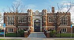 | 347 East 36th Street 44°56′15″N93°16′14″W / 44.93750°N 93.27056°W | 1916 | Tudor Revival | 1997 | 1990 |
| I.O.O.F Hennepin Lodge No. 4 |  | 404 West Broadway 44°59′58″N93°17′7″W / 44.99944°N 93.28528°W | 1897 | 2016 | N/A | |
| Harry W. Jones House |  | 5101 Nicollet Avenue South 44°54′37″N93°16′40″W / 44.91028°N 93.27778°W | 1887 | Shingle; Norman Chateau | 1986 | 1976 |
| Joyce Memorial Methodist Church | 1219 West 31st Street 44°56′47″N93°17′43″W / 44.94639°N 93.29528°W | 1907 | California Mission Revival | 2020 | N/A | |
| V.M.S. Kaufmann House | 20 Park Lane 44°57′22″N93°19′11″W / 44.95611°N 93.31972°W | 1935–36 | International | 1987 | N/A | |
| Kenwood Water Tower |  | 1724 Kenwood Parkway 44°58′3″N93°18′24″W / 44.96750°N 93.30667°W | 1910 | Gothic Revival | 1980 | N/A |
| Charles Frederick Keyes House | 2225 East Lake of the Isles Parkway 44°57′36″N93°18′4″W / 44.96000°N 93.30111°W | 1904 | Craftsman/Queen Anne transitional | 1998 | N/A | |
| Kinnard-Haines Press Company | 826 44th Avenue North 45°2′8.2″N93°17′28.4″W / 45.035611°N 93.291222°W | 1902 | Commercial Utilitarian | 1995 | N/A | |
| Henry E. Ladd House | 131 Oak Grove Street 44°57′58″N93°16′51.5″W / 44.96611°N 93.280972°W | Richardsonian Romanesque | 2011 | N/A | ||
| Lake Harriet Park Picnic Pavilion, and Women's and Men's Rest Buildings |  | 4525 Upton Avenue South 44°55′41.5″N93°18′28″W / 44.928194°N 93.30778°W | 1891 (Rest Buildings)/ 1904 (Picnic Pavilion) | Shingle/Bavarian | 1980 | N/A |
| Lakewood Memorial Chapel |  | 3600 Hennepin Avenue 44°56′10″N93°17′57″W / 44.93611°N 93.29917°W | Byzantine | 1984 | 1983 | |
| Layman's Cemetery |  | 2925 Cedar Avenue 44°56′59″N93°14′41″W / 44.94972°N 93.24472°W | 1853 | 2006 | 2002 | |
| Arthur and Edith Lee House |  | 4600 Columbus Avenue South 44°55′10.5″N93°15′51″W / 44.919583°N 93.26417°W | 1923 | Vernacular | 2016 | 2014 |
| Harry F. Legg House |  | 1601 Park Avenue South 44°58′1.2″N93°15′53″W / 44.967000°N 93.26472°W | 1887 | Queen Anne | 1984 | 1976 |
| P.W. Lein Duplex | 444–446 Madison Street N.E. 44°59′40.5″N93°15′14″W / 44.994583°N 93.25389°W | 1888 | Italianate | 1985 | N/A | |
| John Lind House |  | 1775 Colfax Avenue South 44°57′58″N93°17′29.5″W / 44.96611°N 93.291528°W | 1905–1907 | Georgian Revival | 1985 | N/A |
| Linden Hills Library |  | 2900 West 43rd Street 44°55′30″N93°18′59″W / 44.92500°N 93.31639°W | 1931 | Tudor Revival | 1997 | 2000 |
| Linden Hills Methodist and Episcopal Church |  | 3118 West 49th Street 44°54′52″N93°19′11.5″W / 44.91444°N 93.319861°W | 1907 | Tudor Revival, Craftsman | 1987 | N/A |
| Little Sisters of the Poor Home for the Aged | 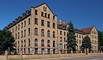 | 215 Broadway Street N.E. 44°59′56.5″N93°15′55″W / 44.999028°N 93.26528°W | 1895; 1905; 1914 | Romanesque Revival | 1979 | 1978 |
| John Lohmar House | 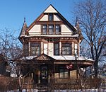 | 1514 Dupont Avenue North 44°59′41.3″N93°17′32″W / 44.994806°N 93.29222°W | 1898 | Queen Anne | 1983 | 1987 |
| Frank B. Long House |  | 25 Groveland Terrace 44°58′3″N93°17′25.5″W / 44.96750°N 93.290417°W | 1894 | Romanesque Revival | 1984 | N/A |
| Loring Theater |  | 1407 Nicollet Avenue South 44°58′7.2″N93°16′39″W / 44.968667°N 93.27750°W | 1920 | Classical Revival | 1990 | N/A |
| Lumber Exchange Building |  | 423–25 Hennepin Avenue 44°58′47″N93°16′19″W / 44.97972°N 93.27194°W | 1885–90 | Richardsonian Romanesque | 1983 | 1983 |
| Charles B. Lyon House |  | 425 Oak Grove Street 44°58′3.5″N93°17′10″W / 44.967639°N 93.28611°W | 1890 | Shingle | 2011 | N/A |
| Daniel B. Lyon House |  | 419 Oak Grove Street 44°58′3″N93°17′9″W / 44.96750°N 93.28583°W | 1892 | Neoclassical | 2011 | N/A |
| MacPhail School of Music |  | 1128 La Salle Avenue South 44°58′23″N93°16′40″W / 44.97306°N 93.27778°W | 1923 | Gothic Revival | 2001 | N/A |
| Madison School | 501 East 15th Street 44°58′4″N93°16′7″W / 44.96778°N 93.26861°W | 1983 | N/A | |||
| Charles J. Martin House |  | 1300 Mount Curve Avenue 44°58′4″N93°17′45.5″W / 44.96778°N 93.295972°W | 1903 | Renaissance Revival | 1986 | 1978 |
| Masonic Temple |  | 524–30 Hennepin Avenue 44°58′45″N93°16′26″W / 44.97917°N 93.27389°W | 1888–90 | Richardsonian Romanesque | 1980 | 1975 |
| Maternity Hospital | 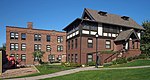 | 300 Queen Avenue North 44°58′49″N93°18′32″W / 44.98028°N 93.30889°W | 1909–11, 1916 | Utilitarian (hospital), Elizabethan (cottage), Bungalow | 1986 | 1980 |
| Mayhew Rowhouses | 614–626 9th Street South 44°58′16.6″N93°15′53″W / 44.971278°N 93.26472°W | 1886 | Richardsonian Romanesque and Queen Anne | 2022 (1988 as contributing resource to Ninth Street South Historic District) | N/A | |
| McKnight Mansion |  | 2200 Park Avenue 44°57′38.4″N93°15′57″W / 44.960667°N 93.26583°W | 1892 | Richardsonian Romanesque | 2016 | N/A |
| Melrose Flats | 13–23 5th Street N.E. 44°59′23″N93°15′13″W / 44.98972°N 93.25361°W | 1890–92 | Chicago Commercial | 1985 | N/A | |
| Louis Menage Cottage | 1808 4th Avenue South 44°57′53.3″N93°16′14″W / 44.964806°N 93.27056°W | 1878 | Gothic Revival | 1983 | N/A | |
| Mikro Kodesh Synagogue |  | 1000 Oliver Avenue North 44°59′17″N93°18′24″W / 44.98806°N 93.30667°W | 1926 | Exotic Revival | 1998 | N/A |
| Milwaukee Road Depot and Freight House |  | 300 Washington Avenue South 44°58′48″N93°15′48″W / 44.98000°N 93.26333°W | 1897–99 | Renaissance Revival | 1979 | 1978 |
| Minneapolis Armory |  | 500–530 6th Street South 44°58′30″N93°15′49″W / 44.97500°N 93.26361°W | 1935–1936 | PWA Moderne | 2017 | 1985 |
| Minneapolis Brewing and Malting Company |  | 1220–1224 Marshall Street 44°59′59″N93°16′13″W / 44.99972°N 93.27028°W | 1891 | Richardsonian Romanesque | ||
| Minneapolis City Hall/The Municipal Building |  | 315 4th Street South 44°58′39″N93°15′55″W / 44.97750°N 93.26528°W | 1889–1905 | Richardsonian Romanesque | 1977 | 1974 |
| Minnesota Spokesman Recorder Building | 3744 4th Avenue South 44°56′4.7″N93°16′13.5″W / 44.934639°N 93.270417°W | 1958 | Modern | 2015 | N/A | |
| Montefiore Cemetery and Chapel |  | 4153 3rd Avenue South 44°55′38″N93°16′18″W / 44.92722°N 93.27167°W | 1890 | Richardsonian Romanesque | 2000 | N/A |
| Moorish Mansion Apartments | 3028 James Avenue South 44°56′50.4″N93°18′13″W / 44.947333°N 93.30361°W | 1929 | Exotic Revival – Moorish Revival | 1985 | N/A | |
| Elisha Morse House |  | 2325-27 Pillsbury Avenue South 44°57′33.5″N93°16′51.5″W / 44.959306°N 93.280972°W | 1870 | Italianate | 1974 | 1995 |
| Henry Neils House |  | 2801 Burnham Boulevard 44°57′29″N93°19′4″W / 44.95806°N 93.31778°W | 1950–1951 | Usonian Style | 1986 | 2004 |
| New Century Mill |  | 545 Oak Street Southeast | 1900 | Burned and demolished in 1990 | 1984 | 1980, de-listed in 1993 |
| George R. Newell House |  | 1818 La Salle Avenue South 44°57′53.2″N93°16′47.5″W / 44.964778°N 93.279861°W | 1888 | Richardsonian Romanesque | 1985 | 1977 |
| John Nordstrom Store | 2110 24th Avenue South 44°57′41.6″N93°14′17″W / 44.961556°N 93.23806°W | 1883 | Italianate, "Boom Town" | 1983 | N/A | |
| North Branch Library |  | 1834 Emerson Avenue North 44°59′55″N93°17′38″W / 44.99861°N 93.29389°W | 1893/1914 | Medieval Revival | 1984 | 1977 |
| North Side Station | 2418 Washington Avenue North 45°0′17″N93°16′53″W / 45.00472°N 93.28139°W | 1914 | Vernacular Industrial with Neoclassical influences | 42156 | N/A | |
| Northern Implement Company |  | 616 3rd Street South 44°58′38″N93°15′35″W / 44.97722°N 93.25972°W | 1910 | Chicago Commercial | 1977 | 1977 |
| Northwestern Knitting Co. (Munsingwear) |  | 718 Glenwood Avenue/275 Market Street 44°58′49″N93°17′20″W / 44.98028°N 93.28889°W | 1910–1915 | Classical Revival | 1984 | 1983 |
| William S. Nott House | 15 Groveland Terrace 44°58′1.5″N93°17′23.3″W / 44.967083°N 93.289806°W | 1893–94 | Romanesque Revival | 1984 | N/A | |
| Oakland Apartments |  | 213 9th Street South 44°58′24″N93°16′14.4″W / 44.97333°N 93.270667°W | 1889 | Richardsonian Romanesque | 2019 | N/A |
| Ogden Apartment Hotel |  | 66–68 12th Street South 44°58′22″N93°16′39″W / 44.97278°N 93.27750°W | 1992 | 1992 | ||
| Old East Lake Library |  | 2916 Lake Street East 44°56′55″N93°13′44.5″W / 44.94861°N 93.229028°W | Utilitarian | 1997 | N/A | |
| Old Walker Library |  | 2901 Hennepin Avenue 44°56′59.5″N93°17′52.5″W / 44.949861°N 93.297917°W | 1911 | Beaux-Arts | 1997 | 2000 |
| Floyd B. Olson House |  | 1914 West 49th Street 44°54′51.8″N93°18′15″W / 44.914389°N 93.30417°W | 1922 | Bungalow | 1986 | 1974 |
| Dr. Oscar Owre House |  | 2625 Newton Avenue South 44°57′27.7″N93°18′22″W / 44.957694°N 93.30611°W | 1912 | Prairie School | 1983 | 1984 |
| Pantages Theater |  | 708 Hennepin Avenue 44°58′41″N93°16′32″W / 44.97806°N 93.27556°W | 1916 | Beaux-Arts (auditorium), Modern (lobby) | 1997 | N/A |
| Charles and Grace Parker House |  | 4829 Colfax Avenue South 44°54′54.3″N93°17′30″W / 44.915083°N 93.29167°W | 1913 | Prairie School | 1996 | 1992 |
| Pierson-Wold House |  | 1779 Emerson Avenue South 44°57′57.1″N93°17′38.5″W / 44.965861°N 93.294028°W | 1892 | Colonial Revival | 2008 | N/A |
| Pilgrim Rest Baptist Church | 5100 James Avenue North 45°2′52″N93°18′5″W / 45.04778°N 93.30139°W | Unknown (moved onsite in 1968) | Vernacular with Gothic Revival influences | 2017 | N/A | |
| Prospect Park Water Tower |  | 55 Malcolm Avenue S.E. 44°58′7″N93°12′46″W / 44.96861°N 93.21278°W | 1914 | 20th Century Revivals | 1984 | 1997 |
| William Gray Purcell House |  | 2328 Lake Place 44°57′33.3″N93°18′3″W / 44.959250°N 93.30083°W | 1913 | Prairie School | 1974 | |
| Elizabeth C. Quinlan House |  | 1711 Emerson Avenue South 44°58′0.8″N93°17′38.6″W / 44.966889°N 93.294056°W | 1925 | Italian Renaissance Revival | 2010 | 2012 |
| Rand Tower |  | 527–529 Marquette Avenue 44°58′39″N93°16′11″W / 44.97750°N 93.26972°W | 1929 | Moderne | 1994 | 1994 |
| Rappaport House | 636 Elwood Avenue North 44°59′8″N93°17′58″W / 44.98556°N 93.29944°W | 1912 | Vernacular with Colonial Revival, Prairie, and Craftsman influences | 2011 | N/A | |
| Roosevelt Library |  | 4026 28th Avenue South 44°55′46.5″N93°13′57″W / 44.929583°N 93.23250°W | 1927 | Tudor Revival | 1997 | N/A |
| Sears, Roebuck and Co. Mail Order Warehouse and Retail Store |  | 2843 Elliot Avenue South 44°56′57″N93°15′39″W / 44.94917°N 93.26083°W | 1927 | Moderne | 2005 | 2005 |
| Second Church of Christ Scientist Tower |  | 1115 2nd Avenue South 44°58′17″N93°16′22″W / 44.97139°N 93.27278°W | 1930 | Moderne | 1986 | N/A |
| Anne C. and Frank B. Semple House | 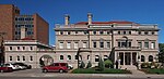 | 100–04 Franklin Avenue West 44°57′47″N93°16′47″W / 44.96306°N 93.27972°W | 1901 | Renaissance Revival | 2006 | 1998 |
| Sharei Zedeck Synagogue |  | 1119 Morgan Avenue North 44°59′22″N93°18′17.5″W / 44.98944°N 93.304861°W | 1936 | Utilitarian | 1998 | N/A |
| Shoreham Yards Roundhouse | 2800 Central Avenue | 1887–1919 Demolished 2019 | Commercial Railroad | 2000 | N/A | |
| Shubert Theater | 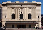 | 22 7th Street North 44°58′46″N93°16′24″W / 44.97944°N 93.27333°W | 1910 | Beaux-Arts | 1990 | 1995 |
| H. Alden Smith House | 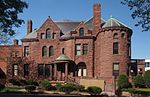 | 1400–10 Harmon Place 44°58′21″N93°16′56.5″W / 44.97250°N 93.282361°W | 1886 | Richardsonian Romanesque | 1980 | 1976 |
| Lena O. Smith House |  | 3905 5th Avenue South 44°55′55.6″N93°16′7″W / 44.932111°N 93.26861°W | 1912 | Classical Revival | 1996 | 1991 |
| John P. and Nelle Snyder Mansion | 2118 Blaisdell Avenue 44°57′40″N93°16′48″W / 44.96111°N 93.28000°W | 1913 | 2016 [5] | N/A | ||
| Soo Line Building |  | 105 5th Street South 44°58′41″N93°16′9″W / 44.97806°N 93.26917°W | 1914–15 | Renaissance Revival | 1996 | N/A |
| St. James AME Church |  | 3600 Snelling Avenue 44°56′15″N93°13′43″W / 44.93750°N 93.22861°W | 1958–1959 | Vernacular with Mid-Century Modern Influences | 2018 | N/A |
| State Theater |  | 805 Hennepin Avenue 44°58′36.7″N93°16′34″W / 44.976861°N 93.27611°W | 1920–21 | Renaissance Revival | 1986 | N/A |
| Stewart Memorial Church |  | 116 East 32nd Street 44°56′43″N93°16′32″W / 44.94528°N 93.27556°W | 1909 | Prairie Style | 1984 | 1978 |
| Sumner Library |  | 611 Emerson Avenue North 44°59′5″N93°17′40.5″W / 44.98472°N 93.294583°W | 1915 | Tudor Revival | 1997 | 2000 |
| Swinford Townhouses/Apartments |  | 1213–21, 1225 Hawthorne Avenue 44°58′31″N93°16′54″W / 44.97528°N 93.28167°W | 1886 (Townhomes)/ 1897 (Apartments) | Romanesque Revival (Townhomes)/Richardsonian Romanesque (Apartments) | 1980 | 1990 |
| Thomas Lowry Memorial |  | 2330 Hennepin Avenue South 44°57′34.5″N93°17′39″W / 44.959583°N 93.29417°W | 1915 | 2015 | N/A | |
| Town Talk Diner |  | 2707½ East Lake Street 44°56′53.5″N93°13′58″W / 44.948194°N 93.23278°W | 1946 | Streamline Moderne | 2013 | N/A |
| Swan Turnblad House |  | 2600 Park Avenue South 44°57′19″N93°15′57″W / 44.95528°N 93.26583°W | 1903–10 | French Chateau | 1974 | 1970 |
| Uptown Theater |  | 2900 Hennepin Avenue 44°56′56.5″N93°17′55″W / 44.949028°N 93.29861°W | 1939 | Streamlined Moderne | 1990 | N/A |
| George W. Van Dusen Mansion |  | 1900 LaSalle Avenue South 44°57′50.3″N93°16′47″W / 44.963972°N 93.27972°W | 1891 | Richardsonian Romanesque | 1995 | 1995 |
| Viehman House |  | 2006 Laurel Avenue West 44°58′27.5″N93°18′18.5″W / 44.974306°N 93.305139°W | 1888 | Queen Anne | 2012 | N/A |
| Lyman E. Wakefield House | 4700 Fremont Avenue South 44°55′3.3″N93°17′46.5″W / 44.917583°N 93.296250°W | 1912 | Prairie School | 1987 | N/A | |
| Benjamin B. Walling House | 4850 West Lake Harriet Parkway 44°54′56.5″N93°18′39.5″W / 44.915694°N 93.310972°W | 1930 | Tudor Revival | 1987 | 1983 | |
| Washburn Park Water Tower |  | 401 Prospect Avenue 44°54′38.7″N93°17′3.5″W / 44.910750°N 93.284306°W | 1931–1932 | Medieval Revival | 1980 | 1983 |
| Wesley Methodist Church |  | 101 Grant Street East 44°58′10.5″N93°16′34″W / 44.969583°N 93.27611°W | 1891 | Richardsonian Romanesque | 1984 | 1984 |
| West Fifteenth Street Rowhouses |  | 115–29 West 15th Street 44°58′3.3″N93°16′49″W / 44.967583°N 93.28028°W | 1886 | 1985 | N/A | |
| White Castle #8 |  | 3252 Lyndale Avenue South 44°56′35″N93°17′18.4″W / 44.94306°N 93.288444°W | 1936 | Vernacular - Programmatic | 1984 | 1986 |
| John A. Widstrom Tenement |  | 617–21 19th Avenue South 44°58′1.5″N93°14′43.5″W / 44.967083°N 93.245417°W | 1886 | Italianate | 1985 | N/A |
| Malcolm Willey House |  | 255 Bedford Street S.E. 44°57′38″N93°12′31″W / 44.96056°N 93.20861°W | 1934 | Prairie School | 1984 | 1984 |
| C. Winston House | 1324 Mount Curve Avenue 44°58′3.3″N93°17′50″W / 44.967583°N 93.29722°W | 1910 | Prairie School | 1987 | N/A | |
| Theodore Wirth House |  | 3954 Bryant Avenue South 44°55′52″N93°17′30″W / 44.93111°N 93.29167°W | 1910 | Colonial Revival | 1998 | 2002 |
| Woman's Club of Minneapolis |  | 410 Oak Grove Street 44°58′4″N93°17′5″W / 44.96778°N 93.28472°W | 1927 | Renaissance Revival | 1998 | 2022 |
| YMCA Central Building |  | 36 9th Street South 44°58′33″N93°16′32″W / 44.97583°N 93.27556°W | 1917–19 | Gothic Revival | 1996 | 1995 |
| Young-Quinlan Department Store |  | 901–915 Nicollet Mall 44°58′29″N93°16′26″W / 44.97472°N 93.27389°W | 1926 | Chicago Commercial, Renaissance Revival details | 1988 | N/A |
Historic Districts
National Historic Districts
Local Historic Districts
- C.A. Smith Lumber Historic District
- Church of the Incarnation Historic District
- Dinkytown Commercial Historic District
- Fifth Street Southeast Historic District
- Golden Valley Road Apartments Historic District
- Harmon Place Historic District
- Lowry Hill East Residential Historic District
- Minneapolis Warehouse Historic District
- Ninth Street South Historic District
- Tilsenbilt Homes Historic District
- University of Minnesota Greek Letter Chapter House Historic District
- Victory Memorial Drive Historic District


