Milwaukee Avenue Historic District

Last updated

Milwaukee Avenue Historic District
Milwaukee Ave Minneapolis 2.jpg
Four houses within the Milwaukee Avenue Historic District
USA Minnesota location map.svg
Red pog.svg
Usa edcp location map.svg
Red pog.svg
Location Minneapolis, Minnesota
Coordinates 44°57′39″N93°14′24″W / 44.96083°N 93.24000°W / 44.96083; -93.24000
Built1885
ArchitectRagan, William
Architectural styleCommon Man's Architecture [1]
NRHP reference No. 74001021 [2]
Added to NRHPMay 2, 1974

The Milwaukee Avenue Historic District is a historic district in the Seward neighborhood of Minneapolis. The district comprises two city blocks of small homes on quarter-sized lots. These houses were built between 1884 and 1890 by William Ragan, a Minneapolis real estate speculator. Built for lower-income residents, the houses had deteriorated in condition by the end of World War II, and by the 1970s, were planned for demolition. A group of residents and concerned citizens fought to save the houses, eventually leading to their inclusion on the National Register of Historic Places and the federal protection and rehabilitation that comes with the designation. Today, the houses sit along a bike- and pedestrian-friendly mall on which motor traffic is prohibited. [3]

Contents

Early history

Residents of Milwaukee Avenue in the early decades of the 20th century Early Milwaukee Avenue.JPG
Residents of Milwaukee Avenue in the early decades of the 20th century

During the late 19th century, the population of Minneapolis was growing rapidly, increasing 351 percent from 1880 to 1890. With the number of people moving into the city, lower-cost housing was needed for immigrants who were new to Minnesota. The street had originally been platted as an alley between 22nd and 23rd Avenues South, but William Ragan developed it as a street and labeled it 22½ Avenue. The houses were situated close together on narrow lots, with very narrow side yards and no front yards. This almost gives the impression of rowhouses. Most of the houses were built with brick veneer on timber frames, and they have uniform-sized roof slopes, modified flat arch windows, and open front porches. [1]

The street kept its '½' until 1906, when petitioners asked the Minneapolis City Council to change the street's name to Woodland Avenue because they said the '½' made them feel like they lived in an alley. [4] For an unknown reason, the street's name was not changed to Woodland Avenue, but to Milwaukee Avenue. The Avenue's proximity to the Milwaukee Short Line Railroad has been suggested as a cause. [4]

Deterioration and restoration

A Milwaukee Avenue house being restored Milwaukee Avenue Restoration.JPG
A Milwaukee Avenue house being restored

By the time World War II was over, the houses on Milwaukee Avenue were falling into disrepair. They had been neglected throughout the Great Depression and wartime. [4] In 1959, the City of Minneapolis presented a plan for the Seward neighborhood, which listed the houses on Milwaukee Avenue in 'deteriorated' condition, meaning they had no indoor plumbing or were severely battered. [5]

In many other neighborhoods, the city had renewed and thus gentrified areas without public hearings, because residents of those neighborhoods were low-income renters. [6] In Milwaukee Avenue's case, however, the residents were of medium income, and seasoned protesters, since many had protested the Vietnam War. By 1970, the City of Minneapolis planned to raze the Milwaukee Avenue houses using funds from the Housing and Urban Development (HUD) program. [7]

The residents of Milwaukee Avenue and the surrounding Seward neighborhood formed the Seward West Project Area Committee (PAC) in order to try to save the Milwaukee Avenue homes. They argued that the houses had significant historic value and needed to be preserved. The City argued that the houses were legally nonconforming, and rehabilitating them would cost more than just building new houses. [8]

The City furthered its plan of renewing the area and took no heed of the PAC. In response, the PAC secretly submitted an application to the National Register of Historic Places for the Milwaukee Avenue district. It was approved on May 2, 1974, by Secretary of the Interior Rogers CB Morton. This meant that the city could not alter or destroy the houses using federal funds without a public hearing. [9]

Nine of Milwaukee Avenue's houses had to be destroyed due to their decrepit conditions and a tenth was moved elsewhere. In the spaces where these houses once stood, townhomes were built, mirroring the style of the original houses. The rest of the houses got new indoor plumbing, new basements, improved woodwork and porches added on. [10] Additionally, a pedestrian mall was built down the center of Milwaukee Avenue to replace a one-way street. The Avenue is now bike and pedestrian friendly, and cars are prohibited. [7]

Milwaukee Avenue today

Milwaukee Avenue in winter Modern Milwaukee Avenue.jpg
Milwaukee Avenue in winter

Milwaukee Avenue still stands today. In 2007, to celebrate the 30th anniversary of Milwaukee Avenue's rehabilitation, self-guided walking tours of eight of the houses were offered to the public. [11]

The houses were featured on local CBS station WCCO-TV's Finding Minnesota series in 2005. [12] The two-minute video segment about the avenue featured interviews with a resident of Milwaukee Avenue, as well as Bob Roscoe, an activist who led the fight to save Milwaukee Avenue. [12]

Related Research Articles

<span class="mw-page-title-main">Richfield, Minnesota</span> City in Minnesota, United States

Richfield is a city in Hennepin County, Minnesota. An inner-ring suburb of Minneapolis, Richfield is bordered by Minneapolis to the north, Minneapolis–Saint Paul International Airport and Fort Snelling to the east, Bloomington to the south, and Edina to the west. The population was 36,994 at the 2020 census.

<span class="mw-page-title-main">Minneapolis City Hall</span> United States historic place

Minneapolis City Hall and Hennepin County Courthouse, designed by Long and Kees in 1888, is the main building used by the city government of Minneapolis, as well as by Hennepin County, in the U.S. state of Minnesota. The structure has served as mainly local government offices since it was built, and today the building is 60 percent occupied by the city and 40 percent occupied by the County. The building is jointly owned by the city and county and managed by the Municipal Building Commission. The Commission consists of the chair of the County Board, the mayor of the City of Minneapolis, a member of the County Board and a member of the Minneapolis City Council. The County Board chair serves as the president of the Commission and the mayor serves as the vice president. The building bears a striking resemblance to the city hall buildings in Cincinnati and Toronto. The City Hall and Courthouse was added to the National Register of Historic Places in 1974.

<span class="mw-page-title-main">Prospect Park, Minneapolis</span> Neighborhood in Hennepin, Minnesota, United States

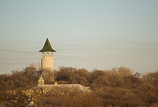
Prospect Park is a historic neighborhood within the University community of the U.S. city of Minneapolis, Minnesota. The area is bounded by the Mississippi River to the south, the City of Saint Paul, Minnesota to the east, the Burlington Northern railroad yard to the north, and the Stadium Village commercial district of the University of Minnesota to the west. The neighborhood is composed of several districts which include the East River Road area. The 1913 Prospect Park Water Tower is a landmark and neighborhood icon.

<span class="mw-page-title-main">Whittier, Minneapolis</span> Neighborhood in Hennepin, Minnesota, United States

Whittier is a neighborhood within the Powderhorn community in the U.S. city of Minneapolis, Minnesota, bounded by Franklin Avenue on the north, Interstate 35W on the east, Lake Street on the south, and Lyndale Avenue on the west. It is known for its many diverse restaurants, coffee shops and Asian markets, especially along Nicollet Avenue. The neighborhood is home to the Minneapolis Institute of Art, the Minneapolis College of Art and Design, and the Children's Theatre Company.

<span class="mw-page-title-main">Neighborhoods of Minneapolis</span> Official communities and neighborhood of Minneapolis

The U.S. city of Minneapolis is officially defined by the Minneapolis City Council as divided into eleven communities, each containing multiple official neighborhoods. Informally, there are city areas with colloquial labels. Residents may also group themselves by their city street suffixes, North, Northeast, South, Southeast, and Southwest.

<span class="mw-page-title-main">Nicollet Island</span> Island on the Mississippi River in central Minneapolis, Minnesota, USA

Nicollet Island is an island in the Mississippi River just north of Saint Anthony Falls in central Minneapolis, Minnesota. According to the United States Census Bureau the island has a land area of 194,407 square metres (0.075 sq mi) and a 2000 census population of 144 persons. The island makes up a large part of the city-designated Nicollet Island/East Bank neighborhood. The island is named for cartographer Joseph Nicollet, who mapped the Upper Mississippi in the 1830s.

<span class="mw-page-title-main">Lake Street (Minneapolis)</span>

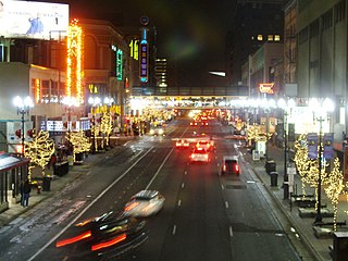
Lake Street is a major east-west thoroughfare between 29th and 31st streets in Minneapolis, Minnesota United States. From its western most end at the city's limits, Lake Street reaches the Chain of Lakes, passing over a small channel linking Bde Maka Ska and Lake of the Isles, and at its eastern most end it reaches the Mississippi River. In May 2020, the Lake Street corridor suffered extensive damage during local unrest over the murder of George Floyd. In August of the same year, city officials designated East Lake Street as one of seven cultural districts to promote racial equity, preserve cultural identity, and promote economic growth.

<span class="mw-page-title-main">Midtown Greenway</span> Shared-use path in Minneapolis, USA

The Midtown Greenway is a 5.7-mile (9.2 km) rail trail in Minneapolis, Minnesota that follows the path of an abandoned route of the Milwaukee Road railway. It is considered under segregated cycle facilities.

<span class="mw-page-title-main">Hennepin Avenue</span>

Hennepin Avenue is a major street in Minneapolis, Minnesota, United States. It runs from Lakewood Cemetery, north through the Uptown District of Southwest Minneapolis, through the Virginia Triangle, the former "Bottleneck" area west of Loring Park. It then goes through the North Loop in the city center, to Northeast Minneapolis and the city's eastern boundary, where it becomes Larpenteur Avenue as it enters Lauderdale in Ramsey County at Highway 280. Hennepin Avenue is a Minneapolis city street south/west of Washington Avenue, and is designated as Hennepin County Road 52 from Washington Avenue to the county line.

<span class="mw-page-title-main">Northeast, Minneapolis</span> Community of Minneapolis

Northeast is a defined community in the U.S. city of Minneapolis that is composed of 13 smaller neighborhoods whose street addresses end in "NE". Unofficially it also includes the neighborhoods of the University community which have "NE" addresses, and the entirety of the Old Saint Anthony business district, which sits on the dividing line of "NE" and "SE" addresses. In the wider community, this business district, which is the oldest settlement in the city, is often identified as the heart of Northeast, in part because it lies across the Mississippi River from Downtown Minneapolis. Northeast is sometimes referred to as "Nordeast", reflecting the history of northern and eastern European immigrants and their language influence.

<span class="mw-page-title-main">Interstate 335 (Minnesota)</span> Highway in Minnesota

Interstate 335 (I-335) is a canceled auxiliary Interstate route in Minneapolis, Minnesota. It was planned to cross Northeast Minneapolis from I-35W south of Broadway to I-94 in North Minneapolis. Land was acquired and some demolition had proceeded when the road was defeated by local opposition.

<span class="mw-page-title-main">St. Anthony West, Minneapolis</span> Neighborhood in Hennepin, Minnesota, United States

Saint Anthony West is a neighborhood in the Northeast community of Minneapolis.

<span class="mw-page-title-main">Mayo Clinic Square</span>

<span class="mw-page-title-main">Gateway District (Minneapolis)</span> Human settlement in Minneapolis, Minnesota, US

The Gateway District of Minneapolis is centered at the convergence of Hennepin Avenue, Nicollet Avenue, and Washington Avenue. Its borders are not officially designated or recognized, but are visible as the Mississippi River to the northeast, Cedar Lake Trail and the railroad tracks to the northwest, Fifth Avenue South to the southeast. and Fourth Street South to the southwest. The district includes a significant part of the Downtown West neighborhood and abuts the North Loop.

<span class="mw-page-title-main">History of Minneapolis</span> History of a US City

Minneapolis is the largest city by population in the U.S. state of Minnesota, and the county seat of Hennepin County. The origin and growth of the city was spurred by the proximity of Fort Snelling, the first major United States military presence in the area, and by its location on Saint Anthony Falls, which provided power for sawmills and flour mills.

<span class="mw-page-title-main">Neighborhoods in Saint Paul, Minnesota</span>

Saint Paul, Minnesota, consists of 17 officially defined city districts or neighborhoods.

Cedar Avenue is a roadway that runs from Minneapolis to Northfield in the U.S. state of Minnesota. The roadway is known as Minnesota State Highway 77 in the busiest portion of the route, from Minneapolis to Apple Valley. The portions north and south of this are county roads, Hennepin County 152 and Dakota County 23, respectively. Its northern terminus in Minneapolis is at Washington Avenue in Cedar-Riverside, though its alignment is briefly interrupted by an interchange at Hiawatha Avenue to the south.

<span class="mw-page-title-main">Summit-University, Saint Paul</span> Neighborhood in Ramsey, Minnesota, United States

Summit-University is a neighborhood in Saint Paul, Minnesota, United States, that stretches roughly from University Avenue in the north, Lexington Parkway to the west, Summit Avenue to the south and to the east along John Ireland Boulevard, Kellogg Boulevard and Marion Street. Summit-University, Selby-Dale, St. Anthony Hill, Cathedral Hill, Woodland Park, Crocus Hill, Ramsey Hill, Hill District, Historic Hill District, Uni-Dale, North Quadrant, and Central Village all refer to parts of the neighborhood that is broadly known as Summit-University.

<span class="mw-page-title-main">Little Earth Trail</span> Shared-use path in Minneapolis

Little Earth Trail is an approximately 1-mile (1.6 km), multi-use bicycle path in Minneapolis, Minnesota, United States, that links several neighborhoods, parks, businesses, and trails in the Phillips community. The trail begins at its northern end near the intersection of East Franklin Avenue and 16th Avenue South and eventually follows the west side of Hiawatha Avenue to the Midtown Greenway and Martin Olav Sabo Bridge. Named after the nearby Little Earth community, the shared-use pathway provides transportation and recreation opportunities, and is a frequent location of activism on social justice issues in Minneapolis.

<span class="mw-page-title-main">38th Street (Minneapolis)</span> Street in Minneapolis

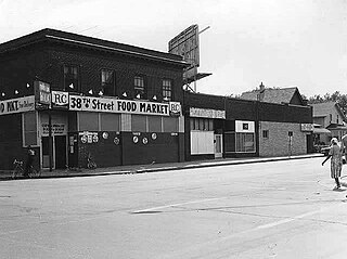
38th Street is a major east-west roadway in the U.S. city of Minneapolis and an officially designated cultural district in the Powderhorn community. The area developed into a residential zone when the Chicago Avenue street car line was extended to East 38th Street in 1880. Since the 1930s, the area has featured many Black-owned businesses, and the surrounding neighborhoods have had distinct histories from other neighborhoods in Minneapolis due to racial settlement patterns that concentrated Black residents there.

References

  1. 1 2 "Milwaukee Avenue Historic District". Minneapolis Heritage Preservation Commission. Retrieved April 1, 2008.
  2. "National Register Information System". National Register of Historic Places . National Park Service. January 23, 2007.
  3. A People's History of the Seward Neighborhood edited by Wendy Epstein, Marilyn Matheny and Rick Musser, (Minneapolis: Nodin Press, 2018) pp. 199-216.
  4. 1 2 3 Richtman, Jerilee N. (Summer 1980). "Milwaukee Avenue Restoration" (PDF). Hennepin County History. Vol. 39, no. 2. pp. 3–16. Archived from the original (PDF) on July 23, 2011.
  5. Minneapolis City Planning Commission (1959). Comprehensive Planning for the Seward Neighborhood. Minneapolis: City of Minneapolis.
  6. Nathanson, Iric (May 15, 1998). "Citizens Determining Neighborhood: the Redevelopment of Seward". Hennepin History. Vol. 57, no. 2. pp. 4–30. ISSN   1062-1067 . Retrieved November 27, 2018.
  7. 1 2 "History". Milwaukee Avenue Homeowners Association. Retrieved June 15, 2008.
  8. "Meeting between Housing & Redevelopment, City Planning and Building Inspections". Minneapolis: Minneapolis Housing and Redevelopment Authority. February 8, 1973.{{cite journal}}: Cite journal requires |journal= (help)
  9. Blankman, Peter (May 14, 1974). "48 homes in renewal area now 'historic'". Minneapolis Star.
  10. "Milwaukee Avenue Historic Restoration Criteria". Minneapolis: Minneapolis Historic Preservation Commission. March 26, 1976.{{cite journal}}: Cite journal requires |journal= (help)
  11. Palmer, Kim (February 19, 2007). "Historic community hosts first home tour". Star Tribune.
  12. 1 2 Tracy, Ben (July 15, 2005). "Finding Minnesota: A Peaceful City Retreat". WCCO-TV . Retrieved June 15, 2008.[ dead link ]

Further reading

Photos