National Register of Historic Places listings in Carver County, Minnesota
Last updated
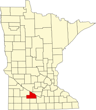
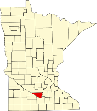
Location of Carver County in Minnesota
This is a list of the National Register of Historic Places listings in Carver County, Minnesota. It is intended to be a complete list of the properties and districts on the National Register of Historic Places in Carver County, Minnesota, United States. The locations of National Register properties and districts for which the latitude and longitude coordinates are included below, may be seen in an online map.
There are 34 properties and districts listed on the National Register in the county. Many structures are built of local Chaska brick, which has a distinctive cream color. A supplementary list includes four additional sites that were formerly listed on the National Register.
Circa-1900 lodging house, the best preserved building associated with Waconia's late-19th/early-20th-century resort industry and the only surviving building designed by primary Coney Island of the West promoter Emile Amblard.[5]
A saloon's livery stable built circa 1875, a rare and well-preserved relic of Chaska's early businesses.[6] Now houses the Chaska Historical Society.[7]
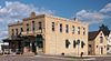
Well-preserved core of a Minnesota River town with about 100 contributing properties mostly built 1855–1880; Carver County's greatest concentration of historically and architecturally significant buildings.[8]
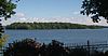
31-acre (13ha) island with the ruins of hotels, cottages, and parks; one of Minnesota's most popular early resort destinations from the 1880s to the 1920s.[11]
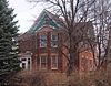
Circa-1870 house of Frederick E. DuToit (1844–1922), newspaper publisher, politician, and a second-generation member of an influential family credited with much of Chaska's commercial growth.[13]
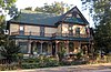
Well-preserved Queen Anne house built circa 1900, the most architecturally significant building in a city that did not usually represent specific architectural styles.[14]
Well-preserved house built circa 1870 by a hotel proprietor also long involved in local politics, one of Chaska's earliest businessmen and public officials.[15]
160-acre (65ha) farmstead with an 1876 house, where German immigrant Wendelin Grimm (1818–1890) developed the first alfalfa that could withstand North American winters.[16] Now a Three Rivers Park District educational facility.[17]
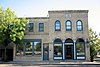
1907 building housing a hardware store that became a consumer cooperative in 1919, illustrating a significant movement in Minnesota that led to advances in agriculture, commerce, milling, and mining, and set the stage for the development of labor unions.[20]
Farmhouse built circa 1895 of Chaska brick, a representative of a major local industry that produced distinctive cream-colored bricks that saw wide commercial and utilitarian use but only appear in houses in the immediate area.[21]
1871 newspaper office and the adjacent building it later expanded into, the long-serving home of the Chaska Herald published by the locally influential DuToit family.[22]
Well-preserved religious complex of Carver County's first Swedish American settlement, later known as East Union, with an 1865 caretaker's cottage, 1866 church, 1874 parsonage, park, cemetery, and a parish hall out of which grew Gustavus Adolphus College.[23]
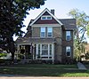
1905 house and carriage house of John Knotz, a long-serving doctor employed by the railroads, and his wife Rosa Partoll Knotz, an early local women's rights advocate who served three terms as Cologne's mayor in the 1920s.[24]
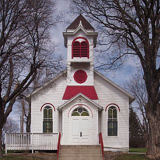
1878 church, a well-preserved example of rural vernacular religious architecture, marking a transition between the spartan frame designs of Carver County's earliest churches and its elaborate later churches of brick.[25]
Circa-1870 house with well-preserved design features, owned successively by the Faber family (responsible for many of Chaska's commercial endeavors) and prominent local doctor E.H. Lewis.[26]
Circa-1875 house inhabited by an owner of a mill that operated 1884–1967, a prominent architectural presence on Waconia's main street and a symbol of its important milling industry.[27]
Circa-1875 cigar factory and adjacent owner's house, a prominent architectural presence on Waconia's main street and the best-preserved buildings associated with its early industries.[28]
Locally prominent house built circa 1880 by town founder and civic leader Paul Mohrbacher, who maintained a lifelong involvement in Cologne's commerce and industry.[29]
Farmstead with five structures associated with Swedish immigrant Andrew Peterson (1818–1898), whose 43-year diary posthumously became a major inspiration for The Emigrants novels by author Vilhelm Moberg in the 1940s and 50s.[31]
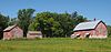
Farmstead significant for retaining structures that illustrate the typical development of Carver County farms, with three 1856 log buildings from the subsistence agriculture period, an 1870s farmhouse expansion due to growing fortunes, and a 1909 barn from a shift to livestock and dairy farming.[32]
1888 saloon/hotel (expanded with living quarters in the 1890s) and adjacent livery stable, some of Chaska's best surviving examples of early commercial architecture and 1880s commercial/residential buildings.[33]
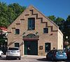
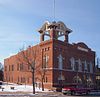
1909 multipurpose municipal building that housed Waconia's government offices, fire department, library, senior center, and meeting hall; noted as a center of community activity and for its locally unique architecture.[34]
Concentration of well-preserved structures ranging from Native American burial mounds to commercial, industrial, residential, and religious buildings, reflecting Chaska's past from prehistory to 1920.[35]
Religious complex of Carver County's first Swedish American settlement, with an 1868 church and freestanding 1905 parish hall featuring elements of rural Swedish parochial architecture.[37]
Circa-1890 saloon with attached living quarters, Norwood's oldest and best preserved drinking establishment and a prominent feature of its downtown.[38]
1909 city hall, the best preserved example of Carver County's monumental early municipal buildings and a prominent Young America landmark long host to its city government.[39] Now a private residence.[40]
Buildings of a brewery established in 1866, nominated as the last standing example of early Chaska's significant brewing industry. Fell into disrepair and demolished in 1989.[43][45]
This list is of the properties and historic districts which are designated on the National Register of Historic Places or that were formerly so designated, in Hennepin County, Minnesota; there are 190 entries as of April 2023. A significant number of these properties are a result of the establishment of Fort Snelling, the development of water power at Saint Anthony Falls, and the thriving city of Minneapolis that developed around the falls. Many historic sites outside the Minneapolis city limits are associated with pioneers who established missions, farms, and schools in areas that are now suburbs in that metropolitan area.
This is a list of the National Register of Historic Places listings in Goodhue County, Minnesota. It is intended to be a complete list of the properties and districts on the National Register of Historic Places in Goodhue County, Minnesota, United States. The locations of National Register properties and districts for which the latitude and longitude coordinates are included below, may be seen in an online map.
This is a list of the National Register of Historic Places listings in Anoka County, Minnesota. It is intended to be a complete list of the properties and districts on the National Register of Historic Places in Anoka County, Minnesota, United States. The locations of National Register properties and districts for which the latitude and longitude coordinates are included below, may be seen in an online map.
This is a list of the National Register of Historic Places listings in Brown County, Minnesota. It is intended to be a complete list of the properties and districts on the National Register of Historic Places in Brown County, Minnesota, United States. The locations of National Register properties and districts for which the latitude and longitude coordinates are included below, may be seen in an online map.
This is a list of the National Register of Historic Places listings in Nicollet County, Minnesota. It is intended to be a complete list of the properties and districts on the National Register of Historic Places in Nicollet County, Minnesota, United States. The locations of National Register properties and districts for which the latitude and longitude coordinates are included below, may be seen in an online map.
This is a list of the National Register of Historic Places listings in Olmsted County, Minnesota. It is intended to be a complete list of the properties and districts on the National Register of Historic Places in Olmsted County, Minnesota, United States. The locations of National Register properties and districts for which the latitude and longitude coordinates are included below, may be seen in an online map.
This is a list of the National Register of Historic Places listings in Fillmore County, Minnesota. It is intended to be a complete list of the properties and districts on the National Register of Historic Places in Fillmore County, Minnesota, United States. The locations of National Register properties and districts for which the latitude and longitude coordinates are included below, may be seen in an online map.
This is a list of the National Register of Historic Places listings in Le Sueur County, Minnesota. It is intended to be a complete list of the properties and districts on the National Register of Historic Places in Le Sueur County, Minnesota, United States. The locations of National Register properties and districts for which the latitude and longitude coordinates are included below, may be seen in an online map.
This is a list of the National Register of Historic Places listings in Washington County, Minnesota. It is intended to be a complete list of the properties and districts on the National Register of Historic Places in Washington County, Minnesota, United States. The locations of National Register properties and districts for which the latitude and longitude coordinates are included below, may be seen in an online map.
This is a list of the National Register of Historic Places listings in Rock County, Minnesota. It is intended to be a complete list of the properties and districts on the National Register of Historic Places in Rock County, Minnesota, United States. The locations of National Register properties and districts for which the latitude and longitude coordinates are included below, may be seen in an online map.
This is a list of the National Register of Historic Places listings in Douglas County, Minnesota. It is intended to be a complete list of the properties and districts on the National Register of Historic Places in Douglas County, Minnesota, United States. The locations of National Register properties and districts for which the latitude and longitude coordinates are included below, may be seen in an online map.
This is a list of the National Register of Historic Places listings in Steele County, Minnesota. It is intended to be a complete list of the properties and districts on the National Register of Historic Places in Steele County, Minnesota, United States. The locations of National Register properties and districts for which the latitude and longitude coordinates are included below, may be seen in an online map.
This is a list of the National Register of Historic Places listings in Chippewa County, Minnesota. It is intended to be a complete list of the properties and districts on the National Register of Historic Places in Chippewa County, Minnesota, United States. The locations of National Register properties and districts for which the latitude and longitude coordinates are included below, may be seen in an online map.
This is a list of the National Register of Historic Places listings in Swift County, Minnesota. It is intended to be a complete list of the properties and districts on the National Register of Historic Places in Swift County, Minnesota, United States. The locations of National Register properties and districts for which the latitude and longitude coordinates are included below, may be seen in an online map.
This is a list of the National Register of Historic Places listings in Dodge County, Minnesota. It is intended to be a complete list of the properties and districts on the National Register of Historic Places in Dodge County, Minnesota, United States. The locations of National Register properties and districts for which the latitude and longitude coordinates are included below, may be seen in an online map.
The Winter Saloon, also known as Harm's Bar, is a historic structure in Norwood Young America, Minnesota, United States. The building was placed on the National Register of Historic Places (NRHP) on January 4, 1980.
Norwood Methodist Episcopal Church, also known as the Church in the Maples, is a historic church in Norwood Young America, Minnesota, United States. The building is in the Romanesque style, which was popular for public buildings in Minnesota but uncommon in Carver County. It has semicircular door and window openings, a wheel window in the belfry, quatrefoil window sash decorations, and broad and smooth walls.
Carver Historic District is a historic district in Carver, Minnesota, United States. It was listed on the National Register of Historic Places in 1980 for having state-level significance in the themes of architecture, commerce, exploration/settlement, industry, and transportation. The district encompasses about 100 contributing properties mostly built from 1855 to 1880. It was nominated for being the well-preserved core of a Minnesota River town, and Carver County's greatest concentration of historically and architecturally significant buildings.
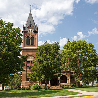
The Swift County Courthouse is the seat of government for Swift County, Minnesota, United States, located in the city of Benson. It has been in continual use since its dedication in 1898. The building was designed in Richardsonian Romanesque style by the architectural firm of Buechner & Jacobson. The courthouse was listed on the National Register of Historic Places in 1977 for having local significance in the themes of architecture and politics/government. It was nominated for its longstanding service as the center of Swift County government and for exemplifying the influence of Richardsonian Romanesque style on late-19th-century public buildings.
Appleton City Hall is a historic municipal building in Appleton, Minnesota, United States. It was built in 1895 as one of the few monumental 19th-century buildings in rural western Minnesota. It initially housed Appleton's government offices, fire department, and jail on the ground floor and an auditorium on the upper floor. The city hall was listed on the National Register of Historic Places in 1977 for having local significance in the themes of architecture and politics/government. It was nominated for supposedly being an example of Richardsonian Romanesque architecture and for its long service as a local government and community center. However other sources describe the building's style less specifically as Romanesque Revival, and its municipal services relocated to other facilities in 1976.
1 2 Numbers represent an alphabetical ordering by significant words. Various colorings, defined here, differentiate National Historic Landmarks and historic districts from other NRHP buildings, structures, sites or objects.
↑ The eight-digit number below each date is the number assigned to each location in the National Register Information System database, which can be viewed by clicking the number.
This page is based on this Wikipedia article Text is available under the CC BY-SA 4.0 license; additional terms may apply. Images, videos and audio are available under their respective licenses.