The Stone Arch Bridge is a former railroad bridge crossing the Mississippi River at Saint Anthony Falls in downtown Minneapolis, Minnesota. It is the only arched bridge made of stone on the entire Mississippi River. It is the second oldest bridge on the river next to Eads Bridge. The bridge was built to connect the railway system to the new Union Depot, which at that time was planned to be built between Hennepin Avenue and Nicollet Avenue. The bridge was completed in 1883, costing $650,000 at the time. 117 Portland Avenue is the general address of the historic complex.
Prospect Park is a historic neighborhood within the University community of the U.S. city of Minneapolis, Minnesota. The area is bounded by the Mississippi River to the south, the City of Saint Paul, Minnesota to the east, the Burlington Northern railroad yard to the north, and the Stadium Village commercial district of the University of Minnesota to the west. The neighborhood is composed of several districts which include the East River Road area. The 1913 Prospect Park Water Tower is a landmark and neighborhood icon.

The U.S. city of Minneapolis is officially defined by the Minneapolis City Council as divided into eleven communities, each containing multiple official neighborhoods. Informally, there are city areas with colloquial labels. Residents may also group themselves by their city street suffixes, North, Northeast, South, Southeast, and Southwest.

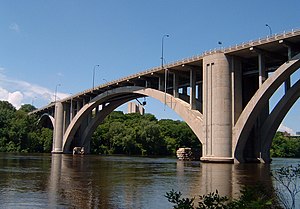
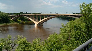
The Third Avenue Bridge is a landmark structure of the city of Minneapolis, Minnesota, United States, originally known as the St. Anthony Falls Bridge. It carries road traffic across the Mississippi River and upper fringes of Saint Anthony Falls. The multi-arched bridge meets with Third Avenue in downtown Minneapolis at its south end, but curves as it crosses the river, and connects with Central Avenue on its north end. The shallow "S" curve in the bridge was built to avoid fractures in the limestone bedrock that supports the bridge piers. The road is also designated Minnesota State Highway 65. Construction began in 1914, and it opened four years later in 1918. The bridge, which uses Melan arches of an open spandrel design, has been modified since that time. The 2,223-foot crossing was designed by city engineer Frederick W. Cappelen, who also created plans for other similar bridges in Minneapolis such as the Franklin Avenue Bridge. It cost US$862,254.00 at the time of construction.

The 10th Avenue Bridge crosses the Mississippi River near downtown Minneapolis, Minnesota and also in proximity to the University of Minnesota. The bridge historically was called the Cedar Avenue Bridge from days prior to the construction of the I-35W bridge when it connected to Cedar Ave. The bridge connects 10th Avenue Southeast, on the east side of the Mississippi River to 19th Avenue South, on the west side. The Seven Corners area of the Cedar-Riverside, Minneapolis neighborhood is at the south end of the bridge. The downstream end of the lower Saint Anthony Falls lock and dam extends under the bridge. The historic Southeast Steam Plant is also nearby.
Kristoffer Olsen Oustad was a Norwegian-American engineer who designed major structures in the United States. Often working together with three other Norwegian-American engineers he designed bridges and other buildings.

Saint Anthony Main refers to an area of buildings with multiple owners located on Main Street across from Saint Anthony Falls in the Nicollet Island/East Bank, Minneapolis section of Southeast, Minneapolis in the U.S. state of Minnesota. Commonly the area is associated with Northeast, Minneapolis as it is actually northeast of downtown on the east side of the Mississippi River. It opened as a festival marketplace in the 1980s.
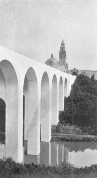
The Cabrillo Bridge in San Diego, California is a historic bridge providing pedestrian and light automotive access between Balboa Park and the Uptown area of San Diego. It was built for the 1915 Panama–California Exposition. The bridge was nominated for the National Register of Historic Places in 1976 and was named a Local Historic Civil Engineering Landmark by the American Society of Civil Engineers in 1986.

The Intercity Bridge, more commonly known as the Ford Parkway Bridge, is a reinforced concrete arch bridge that spans the Mississippi River between Minneapolis, Minnesota and St. Paul, Minnesota, United States. It connects 46th Street in Minneapolis with Ford Parkway in Saint Paul. The bridge is historically significant as one of the largest reinforced concrete bridges ever built in Minnesota. It was built in 1925-1927 by James O. Heyworth, Inc. and was designed by Martin Sigvart Grytbak. The Intercity Bridge was listed on the National Register of Historic Places in 1989. It is notable as one of the monumental concrete rib-arch bridges spanning the high river bluffs along the Mississippi River, along with the Franklin Avenue Bridge, the Third Avenue Bridge, the 10th Avenue Bridge, and the Robert Street Bridge.
The Lake Street–Marshall Avenue Bridge is a reinforced concrete arch bridge that spans the Mississippi River between Minneapolis, Minnesota and St. Paul, Minnesota. It is oriented east-west and connects Lake Street in Minneapolis to Marshall Avenue in St. Paul. St. Paul residents often refer to it as the Marshall Avenue Bridge. The bridge was designed by Howard, Needles, Tammen, and Bergendoff.

The Plymouth Avenue Bridge is a segmental bridge that spans the Mississippi River in Minneapolis. It was built in 1983 and was designed by Van Doren-Hazard-Stallings. The construction of this bridge was unique, for it was the first segmental concrete girder bridge built in Minnesota. This method of design uses a "form traveler" that shapes the concrete as it is built out from the piers. This avoided the use of falsework and avoided impeding river traffic. The concrete is also engineered to be salt-resistant by the use of post-tensioning. Tubes run through the concrete structure carrying strands of cable. With tension on the cables, the structure is designed to be under compression. This prevents cracks and hinders the intrusion of salt water. Since then, other bridges in Minnesota have used this construction method, including the I-35W Saint Anthony Falls Bridge in Minneapolis, the Wabasha Street Bridge in downtown St. Paul, and the Wakota Bridge in South St. Paul.

The I-35W Mississippi River bridge was an eight-lane, steel truss arch bridge that carried Interstate 35W across the Mississippi River one-half mile downstream from the Saint Anthony Falls in Minneapolis, Minnesota, United States. The bridge opened in 1967 and was Minnesota's third busiest, carrying 140,000 vehicles daily. It experienced a catastrophic failure during the evening rush hour on August 1, 2007, killing 13 people and injuring 145. The NTSB cited a design flaw as the likely cause of the collapse, noting that an excessively thin gusset plate ripped along a line of rivets, and that additional weight on the bridge at the time contributed to the catastrophic failure.

Bohemian Flats Park is a park in Minneapolis, Minnesota, United States on the west bank of the Mississippi River near the Washington Avenue Bridge and next to the University of Minnesota campus. The area, once known as Little Bohemia, was the site of a shanty town as Minneapolis was incorporated in 1867. European immigrants seeking employment in the city or at the mills at the nearby St. Anthony Falls settled there. The former housing structures and historic buildings no longer remain. The park is managed by the Minneapolis Park and Recreation Board as part of the Mississippi Gorge Regional Park, and it lies within the Mississippi National River Recreation Area.

The Washburn Park Water Tower is a landmark in the Tangle town neighborhood of south Minneapolis, Minnesota, built in 1931. It is located on top of one of the highest points of south Minneapolis. The tower is considered an unofficial "beacon" for incoming planes landing at Minneapolis-Saint Paul International Airport; however, it is not as visible to passers-by at the base of the hill due to the large homes and tall oak trees scattered on the hillside.

The Hampden County Memorial Bridge is a reinforced-concrete arch bridge that spans the Connecticut River between Springfield, Massachusetts and West Springfield, Massachusetts, constructed in 1922. The bridge is owned by Massachusetts Highway Department and is located on Massachusetts Route 147. It spans 209 feet (64 m) and rises 29.71 feet (9.06 m) above the river.
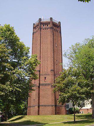
The Kenwood Park Water Tower is an octagonal brick and stone water tower in the Kenwood neighborhood of Minneapolis, Minnesota, United States. It was built in 1910 and designed by Frederick William Cappelen, the city of Minneapolis engineer at the time. The tower is 110 feet tall, making it the tallest structure in Kenwood. The tower has not been used to store water since 1954. The tower was built to alleviate water pressure and storage problems in the Lowry Hill area. Although the tower is not the work of a master architect or representative of a specific architectural style, its design is distinctive. It is ornamented with projecting ribs, narrow rectangular windows, and Lombard bands, suggesting a medieval fortress. The tower serves as a distinct visual focus within the neighborhood.

This list is of the properties and historic districts which are designated on the National Register of Historic Places or that were formerly so designated, in Hennepin County, Minnesota; there are 190 entries as of April 2023. A significant number of these properties are a result of the establishment of Fort Snelling, the development of water power at Saint Anthony Falls, and the thriving city of Minneapolis that developed around the falls. Many historic sites outside the Minneapolis city limits are associated with pioneers who established missions, farms, and schools in areas that are now suburbs in that metropolitan area.

Frederick William Cappelen was a Norwegian-born architect and civil engineer who held the office of Minneapolis City Engineer.
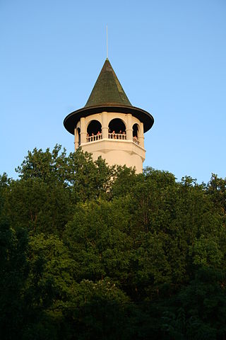
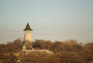
The Prospect Park Water Tower, sometimes referred to as the Witch's Hat Water Tower, is a historic water tower in the Prospect Park neighborhood of Minneapolis, Minnesota, United States. It was built in 1913 on Tower Hill Park, a hilltop park established in 1906. The water tower has become the neighborhood's architectural mascot for its singular design by Frederick William Cappelen. The tower is rumored to be the inspiration for Bob Dylan's song "All Along the Watchtower," as the tower was clearly visible from Dylan's home in nearby Dinkytown.

The Greenfield Bridge, officially known as the Beechwood Boulevard (Greenfield) Bridge II, is a steel arch bridge located in Pittsburgh, Pennsylvania, United States. The bridge connects the neighborhoods of Greenfield and Squirrel Hill across the valley known as Four Mile Run which separates them. The bridge also spans the Parkway East (I-376), which runs along the bottom of the valley.