
The Foshay Tower, now the W Minneapolis – The Foshay hotel, is a skyscraper in Minneapolis, Minnesota. Modeled after the Washington Monument, the building was completed in 1929, months before the stock market crash in October of that year. It has 32 floors and stands 447 feet (136 m) high, plus an antenna mast that extends the total height of the structure to 607 feet (185 m). The building, which was added to the National Register of Historic Places in 1978, is an example of Art Deco architecture. Its address is 821 Marquette Avenue, although it is set well back from the street and is actually closer to 9th Street than Marquette.
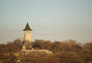
Prospect Park is a historic neighborhood within the University community of the U.S. city of Minneapolis, Minnesota. The area is bounded by the Mississippi River to the south, the City of Saint Paul, Minnesota to the east, the Burlington Northern railroad yard to the north, and the Stadium Village commercial district of the University of Minnesota to the west. The neighborhood is composed of several districts which include the East River Road area. The 1913 Prospect Park Water Tower is a landmark and neighborhood icon.

The U.S. city of Minneapolis is officially defined by the Minneapolis City Council as divided into eleven communities, each containing multiple official neighborhoods. Informally, there are city areas with colloquial labels. Residents may also group themselves by their city street suffixes, North, Northeast, South, Southeast, and Southwest.

University Avenue is a street that runs through both Minneapolis and Saint Paul, Minnesota. It begins near the Minnesota State Capitol in Saint Paul and extends westward into neighboring Minneapolis, where it passes the University of Minnesota, and then turns north to pass through several suburbs before its main portion ends in Blaine, Minnesota, although there are stretches of road designated as University Avenue that are north of the Blaine terminus, the final stretch ending near Andree, Minnesota. For many years, the road carried U.S. Highway 12 and U.S. Highway 52, and University Avenue is still a significant thoroughfare in the area.

The Franklin Avenue Bridge, officially the F.W. Cappelen Memorial Bridge, carries Franklin Avenue over the Mississippi River in Minneapolis, Minnesota. It was designed by Frederick William Cappelen, assisted by Kristoffer Olsen Oustad, both of whom were among four important Norwegian-American engineers working in the region at the time. The reinforced-concrete open-spandrel arched structure was completed in 1923. The bridge's overall length is 1054.7 feet, with a central span of 400 feet. It was added to the National Register of Historic Places in 1978 along with several other area bridges as part of a multiple-property submission. At the time of its completion, the bridge's central span was the longest concrete arch in the world.

The 10th Avenue Bridge crosses the Mississippi River near downtown Minneapolis, Minnesota and also in proximity to the University of Minnesota. The bridge historically was called the Cedar Avenue Bridge from days prior to the construction of the I-35W bridge when it connected to Cedar Ave. The bridge connects 10th Avenue Southeast, on the east side of the Mississippi River to 19th Avenue South, on the west side. The Seven Corners area of the Cedar-Riverside, Minneapolis neighborhood is at the south end of the bridge. The downstream end of the lower Saint Anthony Falls lock and dam extends under the bridge. The historic Southeast Steam Plant is also nearby.

Westminster Presbyterian Church is a Presbyterian Church located in downtown Minneapolis, Minnesota. Its current location is the third location in downtown in over 140 years. The building is listed on the National Register of Historic Places.

The Washburn Park Water Tower is a landmark in the Tangle town neighborhood of south Minneapolis, Minnesota, built in 1931. It is located on top of one of the highest points of south Minneapolis. The tower is considered an unofficial "beacon" for incoming planes landing at Minneapolis-Saint Paul International Airport; however, it is not as visible to passers-by at the base of the hill due to the large homes and tall oak trees scattered on the hillside.
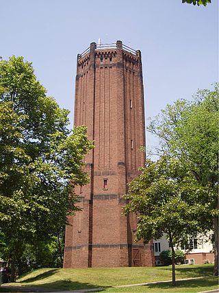
The Kenwood Park Water Tower is an octagonal brick and stone water tower in the Kenwood neighborhood of Minneapolis, Minnesota, United States. It was built in 1910 and designed by Frederick William Cappelen, the city of Minneapolis engineer at the time. The tower is 110 feet tall, making it the tallest structure in Kenwood. The tower has not been used to store water since 1954. The tower was built to alleviate water pressure and storage problems in the Lowry Hill area. Although the tower is not the work of a master architect or representative of a specific architectural style, its design is distinctive. It is ornamented with projecting ribs, narrow rectangular windows, and Lombard bands, suggesting a medieval fortress. The tower serves as a distinct visual focus within the neighborhood.

Clarence Wesley "Cap" Wigington (1883-1967) was an American architect who grew up in Omaha, Nebraska. After winning three first prizes in charcoal, pencil, and pen and ink at an art competition during the Trans-Mississippi Exposition in 1899, Wigington went on to become a renowned architect across the Midwestern United States, at a time when African-American architects were few. Wigington was the nation's first black municipal architect, serving 34 years as senior designer for the City of Saint Paul, Minnesota's architectural office when the city had an ambitious building program. Sixty of his buildings still stand in St. Paul, with several recognized on the National Register of Historic Places. Wigington's architectural legacy is one of the most significant bodies of work by an African-American architect.

The Highland Park Water Tower is a water tower in the Highland Park area of Saint Paul, Minnesota, United States. It was designed by Clarence W. Wigington, the nation's first African-American municipal architect. The tower was listed on the National Register of Historic Places in 1986. It was completed in 1928 at a cost of $69,483.

This list is of the properties and historic districts which are designated on the National Register of Historic Places or that were formerly so designated, in Hennepin County, Minnesota; there are 190 entries as of April 2023. A significant number of these properties are a result of the establishment of Fort Snelling, the development of water power at Saint Anthony Falls, and the thriving city of Minneapolis that developed around the falls. Many historic sites outside the Minneapolis city limits are associated with pioneers who established missions, farms, and schools in areas that are now suburbs in that metropolitan area.

Merchants National Bank is a bank building in Winona, Minnesota, United States, designed in the Prairie School architectural style. It was built in 1912 and features elaborate terracotta and stained-glass ornamentation. It was listed on the National Register of Historic Places in 1974 for having state-level significance in the themes of architecture and commerce. It was nominated for being the "largest and probably best example" of the 18 Midwestern banks designed by Purcell, Feick & Elmslie, a significant influence on early-20th-century American architecture. It is also a contributing property to the Winona Commercial Historic District.
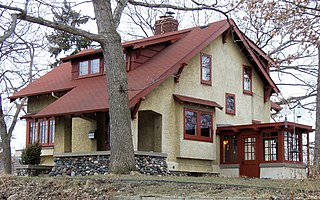
The Lawrence A. and Mary Fournier House is a historic bungalow in the Cleveland neighborhood of Minneapolis, built in 1910. It was designed by architect Lawrence Fournier as a home for himself and his family. It blends early Prairie School-style elements with American Craftsman architecture. It was also one of the first houses built in North Minneapolis.
Frederick William Cappelen was a Norwegian-born architect and civil engineer who held the office of Minneapolis City Engineer.

This is a list of the National Register of Historic Places listings in Becker County, Minnesota. It is intended to be a complete list of the properties and districts on the National Register of Historic Places in Becker County, Minnesota, United States. The locations of National Register properties and districts for which the latitude and longitude coordinates are included below may be seen in an online map.

Mill City Museum is a Minnesota Historical Society museum in Minneapolis. It opened in 2003 built in the ruins of the Washburn "A" Mill next to Mill Ruins Park on the banks of the Mississippi River. The museum focuses on the founding and growth of Minneapolis, especially flour milling and the other industries that used hydropower from Saint Anthony Falls.

The Comstock House is a historic house museum in Moorhead, Minnesota, United States. It was built for Solomon Comstock and his family from 1882 to 1883 in a mix of Queen Anne and Eastlake style. Comstock (1842–1933) was one of Moorhead's first settlers and an influential figure in business, politics, civics, and education in the growing city and state.

The Duluth Armory is a former armory and event venue in the East Hillside neighborhood of Duluth, Minnesota, United States. It was built in 1915 for the National Guard and naval militia, and expanded in 1941. From the beginning the National Guard also rented out the drill hall as an event venue, as it provided a larger and more flexible space than any other local venue until the construction of the Duluth Arena-Auditorium in 1966.

Charles Sumner Sedgwick was an American architect based in Minneapolis, Minnesota.


