Prospect Park, Minneapolis

Last updated

Prospect Park
East Minneapolis
Prospect park witchs hat fall.jpg
Prospect Park viewed from Stadium Village, with the conspicuous Prospect Park Water Tower
Nickname(s): 
The Angle, Tower Hill
MinneapolisProspectParkNeighborhood.PNG
Location of Prospect Park neighborhood within the U.S. city of Minneapolis
Coordinates: 44°58′08″N93°12′45″W / 44.96889°N 93.21250°W / 44.96889; -93.21250
Country United States
State Minnesota
County Hennepin
City Minneapolis
Community University
Founded and Platted1885
Founded byLouis Menage
Named for Prospect Park (Brooklyn)
City Council Ward2
Government
  Councilmember Robin Wonsley
Area
[1]
  Total1.241 sq mi (3.21 km2)
Elevation
951 ft (284 m)
Population
 (2020) [2]
  Total11,354
  Density9,100/sq mi (3,500/km2)
Time zone UTC-6 (CST)
  Summer (DST) UTC-5 (CDT)
Postal code
55414
Area code 612
Website http://www.pperr.org/
Prospect Park Residential Historic District
USA Minnesota location map.svg
Red pog.svg
Usa edcp location map.svg
Red pog.svg
LocationRoughly bounded by University & Williams Avenues SE, Emerald Street SE, and Interstate 94, Minneapolis, Minnesota
Coordinates 44°57′58″N93°12′46″W / 44.96611°N 93.21278°W / 44.96611; -93.21278
Area138 acres (56 ha)
Built1884–1968
ArchitectSamuel Harlan Baker, Joseph H. Gilmore, et al.
NRHP reference No. 15000213 [3]
Designated HDMay 12, 2015
Historical population
CensusPop.Note
1980 4,964
1990 5,0742.2%
2000 6,32624.7%
2010 7,45717.9%
2020 11,35452.3%

Prospect Park is a historic neighborhood within the University community of the U.S. city of Minneapolis, Minnesota. The area is bounded by the Mississippi River to the south, the City of Saint Paul, Minnesota to the east, the Burlington Northern railroad yard to the north, and the Stadium Village commercial district of the University of Minnesota to the west. The neighborhood is composed of several districts which include the East River Road area. The 1913 Prospect Park Water Tower is a landmark and neighborhood icon.

Contents

An urban village once served by streetcar, Prospect Park is now a combination of multiple districts and uses. People live in single-family homes on Tower Hill, as well as apartment housing in the western districts. Estate homes of the early to mid 20th century line East River Road. University Avenue houses a mix of retail and restaurant businesses from the Stadium Village area.

The entire 138-acre (56 ha) core of the neighborhood was listed on the National Register of Historic Places in 2015 as the Prospect Park Residential Historic District for its significance in the theme of social history. It was nominated for its cohesive community spirit, developed—despite the neighborhood's hilly terrain and diverse housing stock—through such innovations as Minneapolis's first community association. [4]

History

In 1874 real estate tycoon Louis F. Menage began plotting new subdivisions along Minneapolis's southern boundaries. [5] Menage petitioned the City Council to accept his Prospect Park plats in 1884. Construction lasted into the 1910s as topography and geographic isolation made building difficult. [6] Houses were designed in the popular architectural styles of the period, especially the Queen Anne and the Colonial Revival styles. [6] The Minneapolis Board of Education constructed the Sidney Pratt Elementary School in 1898. [7]

Thomas Lowry's interurban commuter train served the neighborhood with its stop at Malcolm Avenue [7] until eventually the intercity line between Saint Paul and Minneapolis along University Avenue was opened. The Franklin Avenue Bridge also eventually carried a line.

1909 Racial Conflict

“Race War Started in Prospect Park.” Minneapolis Star Tribune, October 22, 1909. In 1908, a black couple, Madison and Amy Woods Jackson moved into their new brick home in Minneapolis’s Prospect Park neighborhood. They had three young daughters: Marvel, Helen and Zelma.

At the advice of his friend and fellow Pullman Porter Madison Jackson, William H. Simpson had decided to establish a home in the same middle-class neighborhood. Both Jackson and Simpson were African American. Neighbors grumbled when Jackson had moved his family into the all white neighborhood.

On October 21, 1909, a crowd of over one hundred residents marched to the Jackson residence, where Simpson was staying to oversee the construction of his new house. There, they delivered an unequivocal message to Simpson: Members of his race were not welcome in Prospect Park. [8]

Tower Hill

Tower Hill (established 1906), which is the site of the Prospect Park Water Tower, is often cited as the city's highest point [9] and a placard denotes the highest elevation at 951 feet (289.86 m), but a spot at 974 feet (296.88 m) in or near Deming Heights Park in Northeast Minneapolis is corroborated by Google Earth as the highest ground. The Tower, designed by Frederick William Cappelen, is listed on the National Register of Historic Places.

SEMI District

The SouthEast Industrial Area (SEMI) in the north contains light manufacturing, rail yards and remnant grain silos. Many plans for redeveloping the land have been created, including proposals from the nearby University of Minnesota. [10] Starting in the early 2000s, Wall Companies purchased land in the surrounding SEMI District with plans of creating a technology and research campus, with the goal of attracting businesses that wanted proximity to the University of Minnesota. After failing to bring this idea to fruition, a different proposal to create a food hall out of the neighboring Harris Machinery Building, taking advantage of the nearby Green Line and U of M Transitway was implemented. [11] The food hall, named Malcom Yards, was opened to the public in August 2021. [12]

A prominent structure in the SEMI is the ADM-Delmer #4 grain elevator locally known for its United Crushers graffiti on its side. [13] It was originally constructed as a part of the ADM-Delmer facility, named after its owner the Archer-Daniels-Miller company, which started construction in 1925 and ended in 1931. The site was made up of 4 grain elevators. After its abandonment, elevators #2 and #3 where demolished. [10] During the early 2000's, the local graffiti crew United Crushers tagged the southern wall of the elevator.[ citation needed ]

Demographics

The neighborhood is demographically diverse. Tower Hill extending south to the river contains families and retired empty-nesters. The Glendale Housing project southeast of 27th Avenue SE and University Avenue SE contains 700 families with the average household income slightly above $9,000 and 32% of residents living at or below the poverty level. [14] On the former industrial areas of the west and north are newer student housing apartment buildings for both undergraduate and graduate students.

Race

Ethnicity

Government

Prospect Park is entirely within Minneapolis's Ward 2, currently represented by Robin Wonsley on the Minneapolis City Council. The neighborhood association, PPERRIA, founded in 1901, is the oldest neighborhood association in the city of Minneapolis.

Arts and culture

The neighborhood has an annual "Ice Cream Social," a get-together for the neighborhood with food, music and other entertainment. It is the one time of year when the interior of the Prospect Park Water Tower is opened to the public, allowing for a panoramic view of Minneapolis from the top.

Near the south end of the neighborhood on Bedford Street is the Malcolm Willey House, designed by Frank Lloyd Wright and named after a University administrator. The historic significance of the house played a large part in preventing its destruction when Interstate 94 was built in the 1950s. The current goal of the neighborhood is to establish an "urban-village" feel that is, a somewhat self-contained feel in the context of a larger city. Prospect Park also has a few surviving houses from the 19th century. [7]

The neighborhood is home to two community centers, Pratt Elementary School and Luxton Park.

See also

Related Research Articles

<span class="mw-page-title-main">Seward, Minneapolis</span> Neighborhood of Minneapolis

The Seward neighborhood in Minneapolis, Minnesota, United States, is geographically southeast of downtown, consisting of the land bordered by the Hiawatha Avenue industrial district to the west, Minneapolis Midtown Greenway to the south, the Mississippi River to the east, and Interstate 94 to the north. Seward's bordering neighborhoods are Cooper to the southeast, Longfellow to the south, East Phillips to the southwest, Ventura Village to the west, Cedar-Riverside to the north, and Prospect Park/East River Road across the Mississippi River to the east. It is one of the neighborhoods that is part of the larger Longfellow community. Seward was named after former New York senator, governor, and US Secretary of State William H. Seward.

<span class="mw-page-title-main">North Loop, Minneapolis</span> Neighborhood in Hennepin, Minnesota, United States

The North Loop is a neighborhood in the Central community of Minneapolis.

<span class="mw-page-title-main">Holland, Minneapolis</span> Neighborhood in Hennepin, Minnesota, United States

Holland is a neighborhood in the Northeast community in Minneapolis.

<span class="mw-page-title-main">Neighborhoods of Minneapolis</span> Official communities and neighborhood of Minneapolis

The U.S. city of Minneapolis is officially defined by the Minneapolis City Council as divided into eleven communities, each containing multiple official neighborhoods. Informally, there are city areas with colloquial labels. Residents may also group themselves by their city street suffixes, North, Northeast, South, Southeast, and Southwest.

<span class="mw-page-title-main">Nicollet Island</span> Island on the Mississippi River in central Minneapolis, Minnesota, USA

Nicollet Island is an island in the Mississippi River just north of Saint Anthony Falls in central Minneapolis, Minnesota. According to the United States Census Bureau the island has a land area of 194,407 square metres (0.075 sq mi) and a 2000 census population of 144 persons. The island makes up a large part of the city-designated Nicollet Island/East Bank neighborhood. The island is named for cartographer Joseph Nicollet, who mapped the Upper Mississippi in the 1830s.

<span class="mw-page-title-main">10th Avenue Bridge</span> Bridge in Minneapolis, Minnesota

The 10th Avenue Bridge crosses the Mississippi River near downtown Minneapolis, Minnesota and also in proximity to the University of Minnesota. The bridge historically was called the Cedar Avenue Bridge from days prior to the construction of the I-35W bridge when it connected to Cedar Ave. The bridge connects 10th Avenue Southeast, on the east side of the Mississippi River to 19th Avenue South, on the west side. The Seven Corners area of the Cedar-Riverside, Minneapolis neighborhood is at the south end of the bridge. The downstream end of the lower Saint Anthony Falls lock and dam extends under the bridge. The historic Southeast Steam Plant is also nearby.

<span class="mw-page-title-main">Riverside Plaza</span> United States historic place

Riverside Plaza is a modernist and brutalist apartment complex designed by Ralph Rapson that opened in Minneapolis, Minnesota in 1973. Situated on the edge of downtown Minneapolis in the Cedar-Riverside neighborhood, and next to both the University of Minnesota's West Bank and Augsburg University, the site contains the 39-story McKnight Building, the tallest structure outside of the city's central business district. Initially known as Cedar Square West, the complex was renamed when an investor group bought it out of receivership in 1988.

<span class="mw-page-title-main">Elliot Park, Minneapolis</span> Neighborhood in Hennepin, Minnesota, United States

Elliot Park is a neighborhood within the larger Central community in Minneapolis. It was the home of some of Minneapolis's wealthiest citizens in Minneapolis's early years. As the city grew and encompassed the neighborhood, most of the wealthy citizens left to build in more secluded neighborhoods like Lowry Hill and Kenwood. A few historic mansions and buildings from Minneapolis's early years can be found in some parts of Elliot Park.

<span class="mw-page-title-main">Longfellow, Minneapolis</span> Community of Minneapolis

Longfellow is a defined community in Minneapolis, Minnesota which includes five smaller neighborhoods inside of it: Seward, Cooper, Hiawatha, Howe and Longfellow. The community is a mix of agri-industrial properties along the old Northern Pacific Railway, expansive parkland surrounding the famous Minnehaha Falls, and smaller residential areas.

<span class="mw-page-title-main">Stevens Square, Minneapolis</span> Neighborhoods of Minneapolis in Hennepin, Minnesota, United States

Stevens Square is the southernmost neighborhood of the Central community in Minneapolis. Although one of the densest neighborhoods in Minneapolis today, the land was originally occupied by a few large mansions. Today, the area is composed mostly of old brownstone apartment buildings or mansions that have been subdivided into apartments, giving the neighborhood a heavy population density within its small geographical area; a short and wide neighborhood, it is nearly a mile long but only three blocks tall. Much of the neighborhood is a National Historic District, and five of the apartments were listed on the National Register of Historic Places in 1993.

<span class="mw-page-title-main">Northeast, Minneapolis</span> Community of Minneapolis

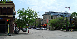
Northeast is a defined community in the U.S. city of Minneapolis that is composed of 13 smaller neighborhoods whose street addresses end in "NE". Unofficially it also includes the neighborhoods of the University community which have "NE" addresses, and the entirety of the Old Saint Anthony business district, which sits on the dividing line of "NE" and "SE" addresses. In the wider community, this business district, which is the oldest settlement in the city, is often identified as the heart of Northeast, in part because it lies across the Mississippi River from Downtown Minneapolis. Northeast is sometimes referred to as "Nordeast", reflecting the history of northern and eastern European immigrants and their language influence.

<span class="mw-page-title-main">St. Anthony Falls Historic District</span> United States historic place

The following are all the contributing resources to the Saint Anthony Falls Historic District in Minneapolis, Minnesota, United States. The District is listed on the National Register of Historic Places, thus these properties are on the NRHP. The "period of significance" of the District was 1858–1941. The district's archaeological record is considered to be one of the most-endangered historic sites in Minnesota.

<span class="mw-page-title-main">Neighborhoods in Saint Paul, Minnesota</span> Group of Minnesota cities

Saint Paul, Minnesota, consists of 17 officially defined city districts or neighborhoods.

<span class="mw-page-title-main">National Register of Historic Places listings in Hennepin County, Minnesota</span>

This list is of the properties and historic districts which are designated on the National Register of Historic Places or that were formerly so designated, in Hennepin County, Minnesota; there are 190 entries as of April 2023. A significant number of these properties are a result of the establishment of Fort Snelling, the development of water power at Saint Anthony Falls, and the thriving city of Minneapolis that developed around the falls. Many historic sites outside the Minneapolis city limits are associated with pioneers who established missions, farms, and schools in areas that are now suburbs in that metropolitan area.

<span class="mw-page-title-main">Milwaukee Avenue Historic District</span> Historic district in Minnesota, United States

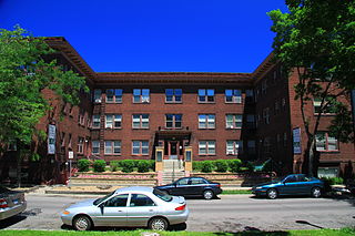
The Milwaukee Avenue Historic District is a historic district in the Seward neighborhood of Minneapolis. The district comprises two city blocks of small homes on quarter-sized lots. These houses were built between 1884 and 1890 by William Ragan, a Minneapolis real estate speculator. Built for lower-income residents, the houses had deteriorated in condition by the end of World War II, and by the 1970s, were planned for demolition. A group of residents and concerned citizens fought to save the houses, eventually leading to their inclusion on the National Register of Historic Places and the federal protection and rehabilitation that comes with the designation. Today, the houses sit along a bike- and pedestrian-friendly mall on which motor traffic is prohibited.

<span class="mw-page-title-main">Prospect Park Water Tower</span> Historic water tower

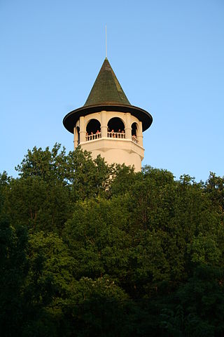
The Prospect Park Water Tower, sometimes referred to as the Witch's Hat Water Tower, is a historic water tower in the Prospect Park neighborhood of Minneapolis, Minnesota, United States. It was built in 1913 on Tower Hill Park, a hilltop park established in 1906. The water tower has become the neighborhood's architectural mascot for its singular design by Frederick William Cappelen. The tower is rumored to be the inspiration for Bob Dylan's song "All Along the Watchtower," as the tower was clearly visible from Dylan's home in nearby Dinkytown.

<span class="mw-page-title-main">Union Park, Saint Paul</span> Neighborhood in Ramsey, Minnesota, United States

Union Park is a neighborhood in Saint Paul in the U.S. state of Minnesota. Created as a merger of several historic neighborhoods including Merriam Park, Snelling-Hamline, Parts of Midway, Densoyer Park, and Lexington-Hamline, it is bordered by University Avenue on the north, Lexington Parkway on the east, Summit Avenue on the south, and the Mississippi National River and Recreation Area on the west. Despite the merger, many of the historic neighborhoods hold onto their original identity, especially in Lexington-Hamline and Merriam Park.

<span class="mw-page-title-main">Charles Sumner Sedgwick</span> American architect

Charles Sumner Sedgwick was an American architect based in Minneapolis, Minnesota.

<span class="mw-page-title-main">Min Hi Line</span> Proposed linear park and shared-use path in Minneapolis

Min Hi Line is a proposed linear park and shared-use path that would eventually re-purpose an active rail and agri-industrial corridor in the Longfellow community of Minneapolis, Minnesota, United States. Modeled after successful projects like the Atlanta Beltline and New York High Line, it would feature an approximately 3-mile (4.8 km), shared-use pathway that traverses housing, retail, commercial buildings, gardens, playgrounds, and public art installments. Two pilot projects completed in 2018 and 2019 connect the Min Hi Line corridor to trail systems at its northern and southern ends.

<span class="mw-page-title-main">38th Street (Minneapolis)</span> Street in Minneapolis

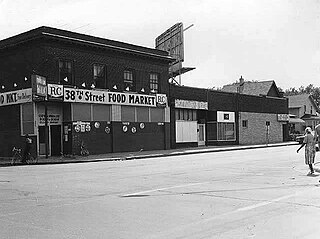
38th Street is a major east-west roadway in the U.S. city of Minneapolis and an officially designated cultural district in the Powderhorn community. The area developed into a residential zone when the Chicago Avenue street car line was extended to East 38th Street in 1880. Since the 1930s, the area has featured many Black-owned businesses, and the surrounding neighborhoods have had distinct histories from other neighborhoods in Minneapolis due to racial settlement patterns that concentrated Black residents there.

References

  1. "Prospect Park neighborhood in Minneapolis, Minnesota (MN), 55414 detailed profile". City-Data. 2011. Retrieved November 12, 2013.
  2. "Prospect Park-East River Road neighborhood data". Minnesota Compass. Retrieved April 2, 2023.
  3. "National Register Information System". National Register of Historic Places . National Park Service. July 9, 2010.
  4. Roise, Charlene; Stephanie K. Atwood; Marjorie Pearson (August 2014). "National Register of Historic Places Registration Form: Prospect Park Residential Historic District" (PDF). National Park Service. Archived from the original (PDF) on April 11, 2016. Retrieved June 25, 2016.{{cite journal}}: Cite journal requires |journal= (help)
  5. Richard Broderick (May 20, 2005). "Erased from Memory". Rake Magazine. Retrieved September 23, 2008.
  6. 1 2 Prepared by Marjorie Pearson; Senior Historian (October 2001). "Prospect Park, Minneapolis: A Historical Survey" (PDF). Hess, Roise and Company. Retrieved October 6, 2008.
  7. 1 2 3 Kahn, Bill (1998). "Sidney Pratt School Centennial". Prospect Park East River Road neighborhood of Minneapolis. Retrieved October 7, 2008.
  8. Star Tribune - Prospect Park 22 Oct 1909|https://www.newspapers.com/article/star-tribune-star-tribune-prospect-par/9708882/
  9. "Minnesota Preservation Planner IX (2)" (PDF). Minnesota Historical Society. Spring 1998. Archived from the original (PDF) on June 15, 2007. Retrieved March 21, 2007. and Bonham, Tim (June 10, 2001). "email". Archived from the original on September 27, 2007. Retrieved January 12, 2007. and "Elevations and Distances in the United States". U.S. Department of the Interior — U.S. Geological Survey. April 29, 2005. Retrieved April 11, 2007.
  10. 1 2 University District Alliance Urban Design Framework Phase III: Transforming the SEMI into a New Innovation District (PDF). University of Minnesota College of Design. 2013. Archived from the original (PDF) on July 13, 2017.
  11. Callaghan, Peter (February 2, 2017). "As Minneapolis booms, can the city preserve places where people actually make stuff?". MinnPost. Retrieved August 24, 2023.
  12. Van Den Einde, Hanna. "The Market at Malcolm Yards set to open on Aug. 5". The Minnesota Daily. Retrieved August 24, 2023.
  13. "About the Prospect North area of Prospect Park Neighborhood Minneapolis". prospectparkmpls.org. Retrieved August 24, 2023.
  14. Council of Large Public Housing Authorities (October 2004). "Modernization in Minneapolis Glendale Family Development: Early Childhood Family Development Center" . Retrieved October 7, 2008.
  15. Bureau, US Census (April 26, 2022). "2020 Census Results". Census.gov. Retrieved September 1, 2022.