William Smith King was a Republican U.S. Representative for Minnesota from March 4, 1875, to March 3, 1877. He was a journalist and businessman. He is best known for allegations of political corruption during this congressional term. The House of Representatives did not specify his offense, but decided it was constitutionally unable to punish him for actions that took place before he entered Congress. He did not run for reelection.

Minneapolis is officially defined by its city council as divided into 83 neighborhoods. The neighborhoods are historically grouped into 11 communities. Informally, there are city areas with colloquial labels. Residents may also group themselves by their city street suffixes, North, Northeast, South, Southeast, and Southwest.

Lowry Hill East, also known as the Wedge because of its wedge-like shape, is a neighborhood in southwest Minneapolis, Minnesota, United States, part of the Calhoun Isles community. Lowry Hill East developed in the 1880s along a horse-drawn streetcar line built by Thomas Lowry. The interior of the neighborhood is residential, with large early 20th century homes and multi-unit apartment buildings, while the border streets are lined with bars, restaurants, grocery stores, coffeeshops, and other small businesses. Most housing is renter-occupied.

The Diamond Lake neighborhood is in the Nokomis community in Minneapolis. It is bounded by Diamond Lake Road and 55th Street on the north, Cedar Avenue on the east, 62nd Street on the south, and Interstate 35W on the west. It has approximately 2233 households within its boundaries. The Diamond Lake neighborhood, together with Hale and Page, forms the HPDL.

The Cooper neighborhood resides along the west shore of the Mississippi River in south Minneapolis. It is bound by 34th St. E. on the south, 38th Ave. S. on the west, 27th St. E. on the north, and the river gorge to the east. Bordering neighborhoods are Seward to the north, Longfellow to the west, and Howe to the south. St. Paul's Merriam Park neighborhood is just across the Mississippi River to the east.

South Uptown is a residential neighborhood of Minneapolis, Minnesota. In 2018, the neighborhood voted to change its name to South Uptown from its former name CARAG. Other potential names for the neighborhood included "Bryant Park" and "Bryant Square". The Minneapolis City Council approved the name change in November 2018.
The Windom neighborhood is located in the Southwest community of Minneapolis. Its borders are Diamond Lake Road and West 54th Street to the north, Interstate 35W to the east, West 62nd Street to the south, and Lyndale Avenue South and Highway 121 to the west. Windom is a part of Ward 11, currently represented by Minneapolis City Council member Emily Koski.
The Southwest community consists of the following neighborhoods: Linden Hills, East Harriet, Kingfield, Fulton, Lynnhurst, Tangletown, Armatage, Kenny, and Windom. This portion of Minneapolis contains many parks and trails along Lake Harriet and Minnehaha Creek.
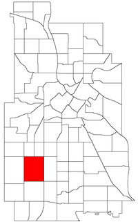
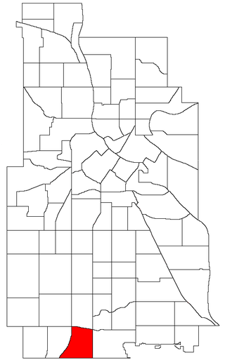
Armatage is a neighborhood in the Southwest community in Minneapolis. In the city's southwest corner, the neighborhood is bounded on the north by 54th Street West, on the east by Logan Avenue South, on the south by Highway 62, and on the west by the city limits at Xerxes Avenue South. Armatage is a part of Ward 13, currently represented by Minneapolis City Council member Linea Palmisano.

Field is a neighborhood in the Nokomis community in south Minneapolis, Minnesota. The neighborhood is bordered by East 46th Street on the north, Chicago Avenue on the east, Minnehaha Parkway on the south, and Interstate 35W on the west. Field shares a neighborhood organization with the Regina and Northrop neighborhoods.

Bancroft is a neighborhood within the Powderhorn community in Minneapolis, Minnesota, United States. Its boundaries are East 38th Street to the north, Chicago Avenue to the west, East 42nd Street to the south and Cedar Avenue to the east. It is entirely located within Minneapolis City Council Ward 8, represented by Andrea Jenkins.

Lyndale is a neighborhood within the Powderhorn community in south Minneapolis, Minnesota, United States. Its boundaries are Lake Street to the north, Interstate 35W to the east, 36th Street to the south and Lyndale Avenue South to the west.

Tangletown is a neighborhood in the Southwest community of Minneapolis. The neighborhood was officially known as Fuller until 1996 when it was changed to the present name, which reflects the winding streets in the neighborhood that do not conform to the regular street grid of South Minneapolis. The neighborhood boundaries are 46th Street to the north, Interstate 35W to the east, Diamond Lake Road to the south, and Lyndale Avenue South to the west. Tangletown is a part of Ward 11, currently represented by Minneapolis City Council member Emily Koski.
Kenny is a neighborhood in the Southwest community in Minneapolis. Its boundaries are West 54th Street to the north, Lyndale Avenue South and Highway 121 to the east, West 62nd Street to the south, and Logan Avenue South to the west. Kenny is a part of Ward 13, currently represented by Minneapolis City Council member Linea Palmisano.

Page is a neighborhood in the Nokomis community in Minneapolis. Its boundaries are the Minnehaha Creek to the north, Chicago Avenue to the east, Diamond Lake Road and East 55th Street to the south, and Interstate 35W to the west. Page shares a neighborhood organization with the Hale and Diamond Lake neighborhoods.
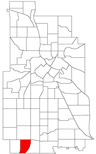
Wenonah is a neighborhood on the southeast side of Minneapolis, Minnesota. Its boundaries are 54th Street to the north, 34th Avenue to the east, the Minneapolis-Saint Paul International Airport to the south, and Cedar Avenue to the west. The neighborhood contains a portion of Lake Nokomis. It shares a neighborhood organization with the Keewaydin, Minnehaha, and Morris Park neighborhoods, which are collectively referred to as Nokomis East and are served by the Nokomis East Neighborhood Association (NENA).

Lynnhurst is a neighborhood in the Southwest community in Minneapolis, Minnesota. Its boundaries are 46th Street to the north, Lyndale Avenue to the east, 54th Street to the south, and Penn Avenue to the west. It is located along the southeastern shore of Lake Harriet. Outflows from the lake run through a parkway for several city blocks to reach Minnehaha Creek.

King Field is a neighborhood in the Southwest community in Minneapolis, Minnesota. Its boundaries are 36th Street to the north, Interstate 35W to the east, 46th Street to the south, and Lyndale Avenue to the west. King Field, within the King Field neighborhood is a park named after Martin Luther King Jr.

Powderhorn is a defined community in Minneapolis, that consists of eight neighborhoods. The greater Powderhorn community is named after Powderhorn Park.

Corcoran is a neighborhood within the Powderhorn community in Minneapolis, Minnesota, United States. The neighborhood is bordered by Longfellow and Howe neighborhoods to the east, Phillips to the north, Powderhorn Park to the west and Standish to the south. Its official boundaries are East Lake Street to the north, Hiawatha Avenue to the east, East 36th Street to the south, and Cedar Avenue to the west. It is entirely located within Minneapolis City Council Ward 9, represented by Jason Chavez.