Dinkytown is a commercial district within the Marcy-Holmes neighborhood in Minneapolis, Minnesota. Centered at 14th Avenue Southeast and 4th Street Southeast, the district contains several city blocks occupied by various small businesses, restaurants, bars, and apartment buildings that house mostly University of Minnesota students. Dinkytown is along the North side of the University of Minnesota Twin Cities East Bank campus.

The Seward neighborhood in Minneapolis, Minnesota, United States, is geographically southeast of downtown, consisting of the land bordered by the Hiawatha Avenue industrial district to the west, Minneapolis Midtown Greenway to the south, the Mississippi River to the east, and Interstate 94 to the north. Seward's bordering neighborhoods are Cooper to the southeast, Longfellow to the south, East Phillips to the southwest, Ventura Village to the west, Cedar-Riverside to the north, and Prospect Park/East River Road across the Mississippi River to the east. It is one of the neighborhoods that is part of the larger Longfellow community. Seward was named after former New York senator, governor, and US Secretary of State William H. Seward.

Minneapolis is officially defined by its city council as divided into 83 neighborhoods. The neighborhoods are historically grouped into 11 communities. Informally, there are city areas with colloquial labels. Residents may also group themselves by their city street suffixes, North, Northeast, South, Southeast, and Southwest.

Lowry Hill is a neighborhood within the Calhoun-Isles community in Minneapolis, Minnesota. The neighborhood is regarded as being one of the city’s most upscale and wealthy neighborhoods. It was historically the home of Minneapolis’s most prominent milling and lumber families.

South Uptown is a residential neighborhood of Minneapolis, Minnesota. In 2018, the neighborhood voted to change its name to South Uptown from its former name CARAG. Other potential names for the neighborhood included "Bryant Park" and "Bryant Square". The Minneapolis City Council approved the name change in November 2018.

Howe is a neighborhood within the larger Longfellow community in Minneapolis. It is bordered by the Cooper and Longfellow neighborhoods to the north, Corcoran and Standish to the west, Hiawatha to the south, and the Mississippi River to the east. The neighborhood and its elementary school are named for Julia Ward Howe.

Hiawatha is a neighborhood within the larger Longfellow community in Minneapolis. It is bordered by Howe to the north, the Mississippi River to the east, Minnehaha Park and Minnehaha neighborhood to the south, and Ericsson and Standish to the west. The Hiawatha neighborhood is bordered by 40th Street to the north, the Mississippi River to the east, 54th Street East to the south, and Hiawatha Avenue to the west.
Armatage is a neighborhood in the Southwest community in Minneapolis. In the city's southwest corner, the neighborhood is bounded on the north by 54th Street West, on the east by Logan Avenue South, on the south by Highway 62, and on the west by the city limits at Xerxes Avenue South. Armatage is a part of Ward 13, currently represented by Minneapolis City Council member Linea Palmisano.

Stadium Village is an area of Minneapolis, Minnesota near the East Bank campus of the University of Minnesota. While not an official neighborhood of Minneapolis, the area is an important commercial district that serves university students with many bars and restaurants. There are plans to incorporate it into an official neighborhood of Minneapolis along with the surrounding area. It is part of Southeast Minneapolis, that part of Minneapolis on the East Bank of the Mississippi River and south of Hennepin Avenue

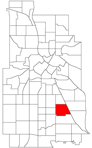
University is a community in Minneapolis. It is composed of seven smaller neighborhoods. It also contains the University of Minnesota campus. Most of the community is commonly referred to as Southeast Minneapolis due street names with a SE suffix.
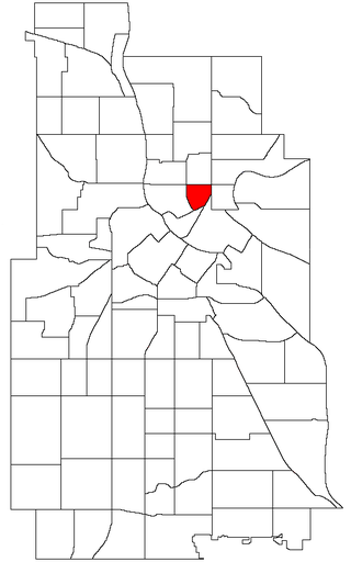
Nicollet Island/East Bank is a neighborhood in the University community of Minneapolis. It is a part of Minneapolis City Council Ward 3, represented by Michael Rainville.

Downtown West is an official neighborhood in Minneapolis, part of the larger Central community. It is the heart of downtown Minneapolis, containing the bulk of high-rise office buildings in the city, and is what comes to mind when most Minneapolitans think of "downtown".

Downtown East is an official neighborhood in Minneapolis, Minnesota, United States. Within Downtown East is the Mill District, which contains former industrial buildings left over from the days when Minneapolis was the flour milling capital of the world. Many of these old mills and factories are being converted to housing, bringing a residential population to a neighborhood that beforehand didn't have many residents. Because of this, the Mill District in Downtown East is one of the fastest growing areas of the city.
Ventura Village is a neighborhood within the Phillips community in Minneapolis. Its boundaries are Interstate 35W to the west, Interstate 94 to the north, and Hiawatha Avenue to the east. The southern boundary runs along East 22nd Street from I-35W to Chicago Avenue, along East 24th Street from Chicago Avenue to 17th Avenue South, and then back up to 22nd Street from 17th Avenue to Hiawatha Avenue. Franklin Avenue, which runs east–west, acts as the main commercial artery in the neighborhood.

Como is a neighborhood within the University community of Minneapolis. It is sometimes referred to as Southeast Como, due to many of its streets ending in SE, and possibly to differentiate it from the Como neighborhood in neighboring Saint Paul. Its boundaries are East Hennepin Avenue to the north, 33rd Avenue Southeast to the east, the Southeast Industrial Area to the south, and Interstate 35W to the west.
Standish is a neighborhood within the Powderhorn community in Minneapolis, Minnesota, United States named after Captain Miles Standish. Its boundaries are East 36th Street to the north, Hiawatha Avenue to the east, East 42nd and 43rd Streets to the south, and Cedar Avenue to the west.
Sumner-Glenwood is a neighborhood in the Near North community of Minneapolis. The neighborhood is roughly contained by 15 city blocks bordered to the north by 11th Avenue North, to the south by Glenwood Avenue, to the east by Interstate 94, and to the west by both Girard Terrace and Emerson Avenue North. The neighborhood includes the Heritage Park mixed-use area.

Morris Park is a neighborhood in the Nokomis community in Minneapolis, Minnesota. Its boundaries are 54th Street to the north, 46th Avenue to the east, the Twin Cities Air Force Base to the south, and 34th Avenue to the west. It shares a neighborhood organization with the Keewaydin, Minnehaha, and Wenonah neighborhoods, which are collectively referred to as Nokomis East and served by the Nokomis East Neighborhood Association (NENA).
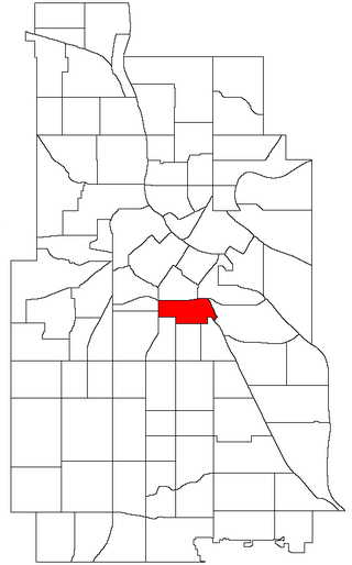
University is a neighborhood within the greater University community in Minneapolis, Minnesota. It is almost completely occupied by the Minneapolis campus of the University of Minnesota, hence the name. It is located entirely within Minneapolis City Council Ward 2, represented by Robin Wonsley.
St. Anthony East is a neighborhood of the Northeast community in Minneapolis.